Depicting Geographic Knowledge: Mariners’ Drawings from Salem, Massachusetts
PATRICIA JOHNSTON
THE ATLAS of the French Pacific explorer La Pérouse was one of the most popular books in Salem at the turn of the nineteenth century. Its title page illustrates contemporary ideas about the vital role that words, images, and objects played in conveying knowledge about the far reaches of the globe (fig. 1). In the 1797 image a winged figure holding an armillary sphere, likely a personification of the wind that drove La Pérouse’s sails, leads the classically draped figure of Navigation toward a large, unscrolled map. Navigation holds a paddle adorned with the image of a dolphin, as it was commonly portrayed on eighteenth-century decorative arts, with a flat rounded bill and split tail. The sea mammal, which in Greek mythology helped sailors by guiding their boats, symbolizes marine power. Circling around the map is a series of putti, some of whom hold the tools of navigation. Counterclockwise from the top, these include a sextant, telescope, hourglass, anchor, and a telltale compass. A large quadrant, a precursor of the sextant, is partially obscured by the map.
Though the map is clearly labeled at the top as the route of La Pérouse, it is somewhat difficult to read because the south is oriented toward the incoming figure on the right rather than toward the viewer. In contrast, the map’s labels are oriented toward the readers; thus the land and sea names are upside down when the map is studied to trace the explorer’s route. In a process perhaps analogous to the experience of Salem’s Federal-period citizens, the resulting initial confusion forces the reader to stop and study before new information can be integrated into existing conceptions of the charted world (fig. 2).
While the figure on the right introduces readers to the world, two on the left record it. At the bottom left, a figure with brushes and palette on the ground to her left sketches the peoples that La Pérouse encountered on his mission; the figure above her looks toward these same subjects with her pen poised to write about them (fig. 3). On his departure from France in 1785 La Pérouse was instructed to “observe the genius, character, manners, customs, bodily constitution, language, government and number of inhabitants.” These directions specified an interest in anthropological observation more intensive than comparable instructions to earlier European expeditions. La Pérouse was also directed to follow Captain Cook’s lead and continue to make botanical and zoological discoveries, to collect “natural curiosities, both of land and sea” that were “to be arranged in order; and a descriptive catalogue of each kind to be drawn up.”1
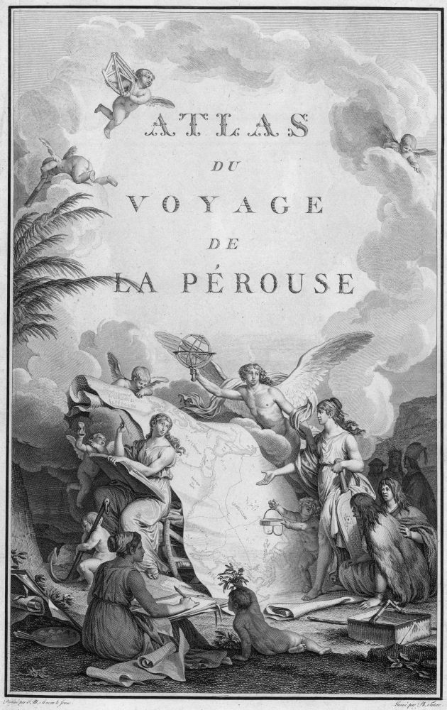
Fig. 1. Title Page to Atlas du Voyage de La Pérouse. Paris: L’Imprimerie de la Republique, 1797. Designed by J. M. Moreau le Jeune; engraved by Ph. Triere and L. Aubert. Courtesy of David Rumsey Map Collection.
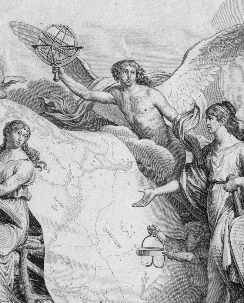
Fig. 2. Detail of Title Page to Atlas du Voyage de La Pérouse.
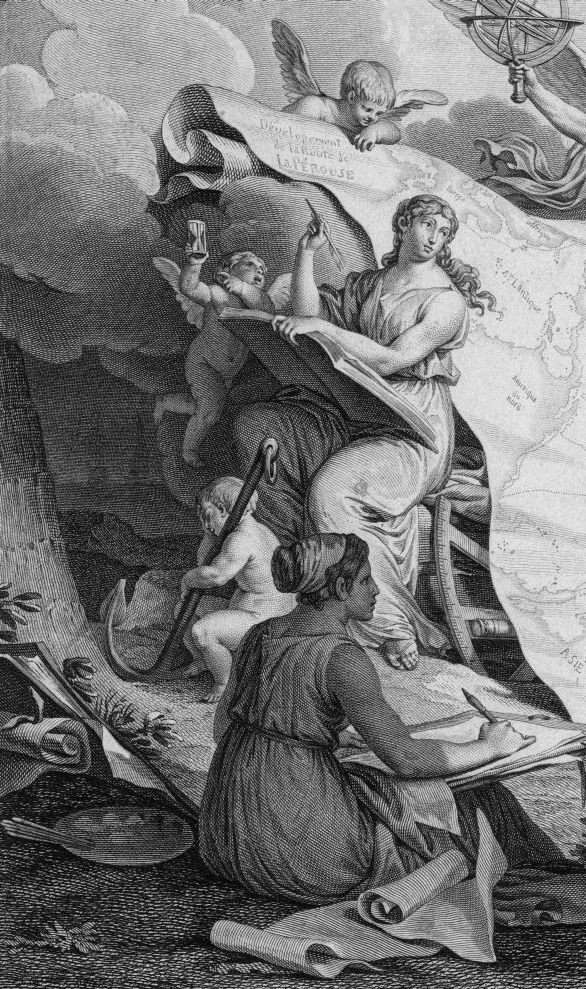
Fig. 3. Detail of Title Page to Atlas du Voyage de La Pérouse.
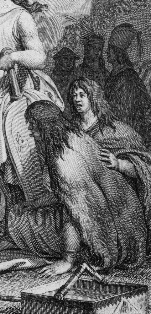
Fig. 4. Detail of Title Page to Atlas du Voyage de La Pérouse.
The indigenous peoples that La Pérouse encountered are represented in striking contrast to the idealized Grecian beauties, perhaps arguing for the superiority of Europe and thus justification of exploitation (fig. 4). In the case of the two fur-clothed figures, who wear clothing similar to those of Alaskan natives pictured in later parts of the book, there is an obvious attempt to represent them as crude and animalistic; the illustrator emphasizes unique cultural practices, such as the labret implanted in the lips, that would be shocking to European readers. The three native figures in the background have more distinctive costuming, with headdresses that suggest Aleutian and Asian identities. At the bottom center, another putto holds up a botanical specimen. The native peoples and plants refer to the research goals of La Pérouse’s expedition. In essence, the title page of the atlas is an allegory of the acts of gathering and studying botanical and ethnographic information via text and image.
La Pérouse’s atlas was read by the intellectual and maritime elite in Salem, likely because it reinforced their belief in the value of studying the wider world. The atlas illustrated the importance of recording geographical and cultural information, just as Salem’s merchants and mariners were developing new American trade routes. British colonial regulations had limited American ships to the Atlantic Basin. Building new legal global trade after the Revolution required geographical information, such as the location and depth of harbors, channels, and shoals, and cultural knowledge, such as indigenous customs and currencies.
By 1800 Salem was a thriving seaport of 9400 people nestled along a shallow, protected harbor halfway between the bustling state capital of Boston and the small fishing village of Gloucester at the tip of Cape Ann. Vessels preparing for, or returning from, international voyages lined Salem’s nearly thirty wharfs. Tea, coffee, spices, wines, textiles, shoes, and ceramics packed its harbor stores. The Salem fleet traded from the Baltic to the Mediterranean, and from the Indian Ocean to the Pacific—truly a global reach. By 1800 international trade had transformed Salem into the sixth largest city in the new United States, after Boston, New York, Philadelphia, Baltimore, and Charleston.2
Salem’s merchants and mariners shared a remarkable visual culture of prints and drawings that provided specific knowledge of distant parts of the world at a level of detail that made them more competitive in the emerging Asian and Pacific trade. Part of this visual culture consisted of printed images—often expensive, luxurious illustrations for voyage narratives, such as those engraved for the La Pérouse atlas, which were typically imported from London or printed in the larger American cities.3 Another part of this visual culture was made up of unique images; these maps and sketches were drawn by mariners and incorporated into ships’ logs and other navigational documents. Both print and manuscript representations were significant in building the rich archive available in the town. Many Salem sea captains and traders felt an obligation to contribute to the archive, using the language of drawing to share information they gathered on their voyages.
Modes and venues for sharing geographic knowledge have existed for many centuries; for instance, manuscript maps circulated in the middle ages. In the colonial period, Americans shared knowledge primarily through kinship networks, fraternal organizations, and fledgling libraries. During the Early Republic, these venues for the circulation of information and ideas became more formalized. By 1800 Salem had flourishing networks for sharing information. Subscription libraries such as Salem’s Social Library acquired and circulated published materials to members, while fraternal organizations such as the East India Marine Society promoted exchanges of personal seafaring and trading experiences. These institutions strengthened ties among the community’s elite and provided them with a competitive edge in trade. Access to global geographic information—combined with navigational skill, business sense, and a measure of good luck—could lead to great wealth and prestige. This commercial success, built on international trade, reinforced a change in American identity from colonial subjects on the margin of empire to international trading partners in a thriving global marketplace.
The Social Library
Following patterns established in other American seaports, Salem quickly built institutions to provide the knowledge necessary for success in the expanded international economy.4 Founded in 1761, Salem’s Social Library grew out of an earlier intellectual men’s gathering called the Monday Night Club. The Social Library counted among its members many of Salem’s merchants and sea captains, along with doctors, lawyers, and ministers—and sometimes their widows and daughters, who could inherit shares. The original collection of the Social Library conformed to typical American eighteenth-century reading patterns: doses of Greek and Roman history, philosophical and theological treatises, and the new literary form of the novel. However, as might be expected in a seaport, the holdings also had a strong international focus with a large selection of published chronicles of sea voyages.5 The prominent physician Edward Augustus Holyoke donated a Book of Mapps. The original library also held the Koran Tales, the Life of Mahomet, Piratical States of Barbary, and the Life of Czar.6
In the Early Republic the continuing Social Library was a significant resource for global information in town, though as a private library access was restricted to the families of those who could afford to purchase a share. The library closed during the Revolution, and its archives show little activity through the 1780s, a period of economic depression in Salem. The phenomenal growth of shipping and disposable income in the 1790s, when Salem traders opened new paths to the East Indies, was matched by lively interest in the library. After a long lull, the library admitted eleven new members in 1796. Each year afterward, several members joined until 1810, when the Social Library merged with the Philosophical Library (whose members were largely ministers and its collections comprised primarily of science, philosophy, and theology texts) to form the present Salem Athenaeum.7 New members of the Social Library circa 1800 included physicians, lawyers, shopkeepers and pharmacists, as well as some of the town’s leading shipowners and sea captains.
The Salem Athenaeum archives hold extraordinary resources in the form of two charge books that record the books that Social Library members took home. The first one begins with the library’s establishment in 1761. The second begins with the influx of new members in 1796. Arranged by shareholder, these charge books allow study of both the popularity of specific books and the taste of individual readers.8 The acquisitions and circulation patterns reveal how widely read were Salem’s citizens and how wide-ranging their knowledge of the world.
The most in-demand books were voyage narratives. The publication of Cook’s Voyages set off a publishing trend on both sides of the Atlantic that was reflected in Salem’s libraries. It seemed that readers could not get enough illustrated natural history and travel adventure literature; tales by Anson, Volney, Park, Coxe, La Pérouse, Bruce, Shaw, Anacharsis, Ulloa, and Niebuhr were always checked out.
Two examples of members’ reading lists, one a merchant and one a sea captain, suggest the reading patterns of the elite. William Gray—shipowner, merchant, and one of the wealthiest men in Salem—preferred travels, histories, and nature studies. Much of his reading focused on the Middle East: Shaw’s travels to the Barbary Coast, Cyrus’s travels to Persia, Dallaway’s Constantinople, and the Life of Mahomet. Gray was equally interested in Europe; he checked out Nugent’s Grand Tour and Robertson’s History of Scotland, as well as compilations of comedies and tragedies. Like most other members of the Social Library, Gray did not seem concerned that information might be outdated. With equal regard, members checked out the new books and the original 1761 collection (which included books such as the Life of Mohamet, written decades before the library was founded).
Benjamin Hodges, who sailed to China in 1788–90 as captain of Gray’s ship, the William and Henry, had a reading list heavy on history, literature, and aesthetics. Typical of most library patrons, he examined Park’s travels to Africa, Moore’s travels to Italy and France, Bourgoanne’s travels in Spain, and Wilson’s account of the Pelew Islands. Though Hodges might be intrigued by such firsthand narratives, the books he took out had little to do with the destinations to which he actually sailed: China, Russia, India, the Caribbean, and others. Of these he had firsthand experience, and his charge records show no evidence of research or reading about these places. It might be however, that the Social Library was not Hodges’s key repository for research for his own travels. He was a founding member of the East India Marine Society, and thus had access to their more specialized library and owned a number of books himself, although it is impossible to say which, because the titles of his personal library were not listed in his estate inventory.
Other libraries in Salem followed much the same pattern. The Library of Arts and Sciences, another private subscription institution founded in 1802, was heavy on expedition narratives, with holdings such as the twenty-volume collection of Mavor’s Voyages, as well as history, theology, philosophy, and aesthetics. While some selections, such as Roman History or the Encyclopedia Britannica might have been found anywhere in the United States, some, such as Gentoo [Hindu] Laws, were unusual holdings but appropriate for an international seaport.9 Libraries continued to be founded in Salem; by 1830 there were seventeen specialized libraries in the city.
One of the most popular reading emporiums was run by John Dabney, a newspaper publisher who in 1786 started the Salem Mercury, then published the Salem Gazette. In his newspapers, Dabney advertised the great variety of holdings for sale or rent: “divinity, history, biography, travels, voyages, memoirs, miscellanies, novels and poetry.” While some holdings overlapped those of the other libraries in town, the titles here tilted more toward entertainment. Visitors could chose selections such as Henry Fielding’s Amelia, or the Distressed Wife, the Arabian Nights Entertainments, or other popular literature.10
Private collections augmented Salem’s libraries. In a town that had both money and culture, some personal libraries became quite extensive. Ministers, of course, collected books. Reverend Thomas Barnard had 600 volumes, which he frequently lent out.11 Reverend Bentley collected over 4000 books during his thirty years in Salem. Wealthy merchants also bought books; Elias Hasket Derby, for example, bought a London collection of 700 books that came on the market, practically sight unseen. Books from these personal libraries circulated among friends and family.
East India Marine Society: Books and Charts
The East India Marine Society, founded in 1799, was the most significant organization in Salem for sharing global knowledge. Marine societies, common in seaports, typically emphasized charitable activities. The EIMS was a more select marine society, with an elite membership limited to sea captains and supercargoes (that is, the head traders) who had rounded either the Cape of Good Hope or Cape Horn to engage in Asian commerce.12 Global knowledge was traded at its regular meetings and dinners, and also through its map, book, and object collections. Unique among such organizations, members were required to collect objects for its museum and to keep voyage logs for its library.13 The EIMS collection of books and voyage logs provided the members with information, and thus a competitive edge, not available otherwise. Members could view visual records of the wider world in the illustrations of published voyage narratives, or in images drawn by their brother mariners for their own voyage logs.
Though large selections of published sea chronicles also filled other Salem libraries, the East India Marine Society library was designed to do more: it targeted acquisitions tightly rather than comprehensively. The book committee, authorized to use the dues to buy any published “Books of History of Voyages and Travels and of Navigation” that might be useful to members, focused on very expensive volumes that even their well-off members chose not to purchase for their personal collections. While no early catalogue of the books has survived, the minutes of the meetings mention some specific acquisitions, and the number of volumes seems to have reached about 250 by 1830. As would be expected, the library held an elaborate multi-volume edition of Cook’s Voyages, which was checked out by Captains Gardner, Pickman, and others. Most members, however, probably owned their own editions, even if they were less elegantly illustrated.14
One of the first purchases for the EIMS library was the large 1799 London edition of La Pérouse’s voyages, with deluxe engravings copied after the earlier French edition. The EIMS’s luxe edition of La Pérouse was continually checked out—to mathematician Nathaniel Bowditch, then Captains Devereux, Lambert, and Prince.15 La Pérouse was one of the most popular authors in Salem, perhaps because he traveled to less well-known parts of the Pacific, such as the northwest coast and south sea islands, which Salem mariners targeted as the next areas of opportunity.16
In 1801 the East India Marine Society decided to purchase the heavily illustrated volume of Vancouver’s voyages. Vancouver also traveled to Pacific territories unknown to Salem voyagers. They paid book dealer John West the enormous sum of $39.12 for the three quarto volumes of text and a fourth folio of maps and engravings, then incurred the further expense of $8.25 for West to bind the volumes.17 No doubt Salem mariners were so eager to study La Pérouse and Vancouver because they planned to initiate trans-Pacific routes to replace the traditional Salem route to India and China by way of the Cape of Good Hope.
The EIMS also purchased fifteen of John Churchman’s variation charts for $52.50.18 Churchman’s variations were a series of sea charts of the Mid-Atlantic coast that were very useful for the frequent runs that distributed imported Asian goods to the American cities to the south. Churchman’s variations were among the library’s most valued items; individual charts were continually checked out by Captains Taylor, Sage, Orne, George Hodges, and Benjamin Crowninshield in preparation for their journeys.19
Voyage Logs and the Topographical
Perhaps most importantly, the EIMS library collected unique information valuable for international navigation and trade. The bylaws required that all members returning from voyages present their journals to the library committee, and beginning in 1801, the Society even provided blank printed journals for seafarers. As Inspector of Journals, Nathaniel Bowditch, author of the pathbreaking New American Practical Navigator, arranged and wrote a table of contents for the voyage logs, then had them bound. The blank logs provided form fields to systemize the requested information, yet left blank pages for flexibility in individual contributions. Following established maritime traditions of voyage logs, the book was labeled with the name of the ship’s master and the person keeping the journal (who might be the master, supercargo, or first mate), and the destination. The writer recorded each day’s longitude and latitude, and the “general state of the weather, winds, currents, bearings of capes, islands, &c. with their estimated distances and, any other remarks that may be useful to navigators.”
These journals were sometimes illustrated. Salem mariners’ drawings reflect the conventions of European naval illustration and charting, popular drawing manuals, and engraved voyage illustrations. They were following a long history of drawing as a language for communicating knowledge about the world. Mapping and some landscape representations were practiced in the ancient world. As early as the fourteenth century, meticulous botanical studies were drawn for Italian textbooks. Global exploration in the sixteenth century encouraged the development of images of panoramic views.20
In the eighteenth century, topographical studies provided both informational and aesthetic value.21 Artistic representation was an integral part of eighteenth-century expeditionary voyages; Captain Cook, for example, brought artists on each of his three voyages. Military officers in training at the Royal Naval College and men preparing to join the British East India Company received artistic training, particularly in drawing and watercolor, before they were deployed abroad.22 Drawing coastal outlines and perspective views for future ventures was perhaps an even more important visual task than recording scientific and cultural information, and voyage narratives such as Cook and La Pérouse often had an equal or greater number of charts than illustrations. Although much of the literature on the history of drawing in the eighteenth century has emphasized its role as a polite art, practiced by women, it was also a very practical and valuable masculine art, with military, scientific, and commercial applications.23
Salem mariners recognized the limits of published information and the dangers that could befall them in unfamiliar waters and ports. They also recognized the value of their experience for others. Luther Dana displayed such self-awareness when he served as the ship’s master and journal keeper of the Recovery on its voyage from Salem to Mocha, a port city on the coast of the Red Sea in Yemen, which was renowned for its chocolate flavored coffee. Referring to a compass that consistently gave him erroneous readings, Dana wrote that he, “The Journalist,” omitted the readings to avoid misleading others. Dana commented throughout the log that the charts he had were incorrect. He recorded no information about people or customs, rather his prose attempted to capture his views of the coast so that others could replicate his journey with greater ease. Passing “Cape Guardufoi” [Cape Guardafui] on the horn of Africa in present-day Somalia, Dana noted “This land is remarkable for appearing like two white Peaks, one with a block Top.” It reminded him of “a large rigged vessel.” He observed that at first it appears as five islands, but as one gets closer he can see they are joined as one. Perhaps Dana simply described landmarks rather than comment on them because he saw little charm in the landscape: a place “without the least appearance of verdure.”24
Dana’s drawing style parallels his prose style: it is informational. In his drawing of Cape Babel Mandel, his concern is to provide enough detail that future mariners can recognize they have reached the landmark, and know what to do to get from there to Mocha. In a sketch that he titled Appearance of Cape Babel Mandel as you come from the Westd, Dana labels five distinct landmarks with the letters A through E (fig. 5), and places a compass underneath. Dana’s drawing of the coastline spreads across the full length of the page. The sea is simply suggested: it is the void between bases of the horizontally aligned landmasses. Yet the implied sea passages between the land are as much the point of the drawing as the land forms. The key beneath the first land form on the left labels A as an island, but it is the empty area B that is more significant—the famous “Streights of Babel Mandel,” which voyagers must enter to reach their destination of Mocha. C labels Cape Babel Mandel itself, and D demonstrates the primary point of the drawing. This empty area to the left of the Cape could be treacherous: “At a Distance or in the dark thick weather a Stranger would likely to suppose this to be the Streights.” The sea at the letter E, where a landmass seeming to be an island is connected to the mainland by an isthmus, is another possible deception that “might Easily be taken for the Entrance.”
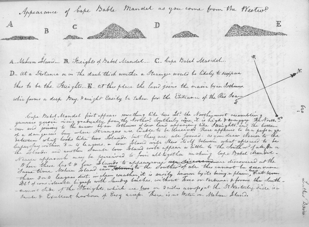
Fig. 5. Luther Dana, Appearance of Cape Babel Mandel as you come from the Westd. Log of the Recovery, Salem to Mocha, 1800–1801. East India Marine Society papers MH-88, Volume 1, p. 620. Courtesy of the Phillips Library at the Peabody Essex Museum, Salem, Massachusetts.
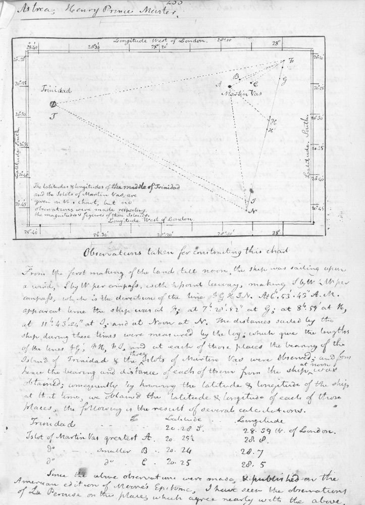
Fig. 6. Nathaniel Bowditch. Longitude and Latitude of Trinidad. Log of the Astrea, Salem to Lisbon, Madeira, and Manilla, 1796–1797. East India Marine Society papers, MH-88, Volume 1, p. 255. Courtesy of the Phillips Library at the Peabody Essex Museum.
Dana’s drawing and its labeling warn his fellow seamen to be on the lookout for this critical juncture since they might easily be confused and drawn off course here. Since the sea is suggested rather than represented, it projects a calm presence between solid landmasses. But Dana’s words belie the idyllic scene: “Cape Babel Mandel first appears something like two Isld the Northernmost resembling gunners quoin rising gradually from the Northwrd. Southerly where it is high and craggy,” it has a “dangerous bay where Strangers are likely to be deceived.”
Despite this geographic focus in Dana’s drawing, his visual vocabulary borrows from the fine arts. He uses delicate hatches that are arranged into lines that curve and change direction to suggest volumes and shifting planes on the hilly coast. This drawing style, and the convention of alphabetic labeling, are drawn from the long history of engraving, an art he was familiar with from illustrated voyage narratives.
Indeed, many of the illustrations in voyage logs were even more mathematical and less artistic in character. Nathaniel Bowditch, as journal keeper of the ship Astrea commanded by Henry Prince included a chart he made to plot the longitude and latitude of Trinidad (fig. 6).25 Bowditch’s visual language is comprised of numbers and triangles; his goal safer, more efficient navigation. It is based on standard conventions for sea charts, which he sought to make more reliable.
Drawings of harbors were very much tied to print traditions. William Haswell’s drawings of the port of Manila illustrate the standard conventions of how mariners used different types of topographical charts and views to synthesize crucial information. In one example, Haswell presents a Plan of the Bay of Manila in the Isle of Lucona, a sea chart of the harbor that echoes the standard conventions (fig. 7). In a decorative cartouche, he clearly labels it a copy, even as he signs it. The image is based on a survey of the harbor by Señor Don Malaspina. It includes the symbols necessary for decoding it: a scale, a compass, numbers indicating harbor depths, and the names of notable features. In both Bowditch’s visual computation and Haswell’s more accessible chart, the sea is enlivened with both visual description and data; the land is a void, terra incognita to the seafarer.
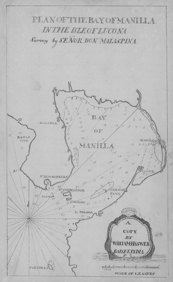
Fig. 7. William Haswell. Plan of the Bay of Manilla in the Isle of Lucona. Logs of the Elizabeth, Charlotta, and Pallas, 1801–1803. Courtesy of the Phillips Library at the Peabody Essex Museum.
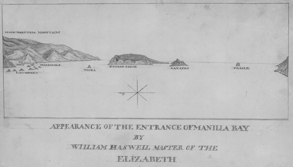
Fig. 8. William Haswell. Appearance of the Entrance of Manilla Bay. Logs of the Elizabeth, Charlotta, and Pallas, 1801–1803. Courtesy of the Phillips Library at the Peabody Essex Museum.
Mariners sometimes used this information in conjunction with their own personal observations as the basis of landscape drawings to depict harbors as they were perceived during arrival by sea. In another image, Haswell provides an experiential image of the more informational hydrographic survey, an acknowledgement that mariners needed both, and perhaps referencing the long tradition of drawing coastal profiles (fig. 8). Haswell neatly labeled the Appearance of the Entrance of Manilla Bay in both its title and the names of the mountains and islands, the key landscape features seen on entering the bay. In images such as this, documentary goals combine with artistic landscape ambitions. Haswell’s pencil traces the light hitting the front of mountains and the islands rising out of the sea. Shadows emphasize their three-dimensionality. A single line separates the sea from the sky and the landforms are aligned on a single horizontal axis. A simple unlabeled compass placed in the center orients the viewer. The result is a drawing that captures the distinctive topography of Manila harbor. Only essential information is represented and a complex view is reduced to easily understandable information.
Like most mariners, Haswell came from a seafaring family. His father and grandfather had served in the Royal Navy; his brother Robert Haswell was a mate on the Columbia, which left from Boston to become the first American ship to circumnavigate the world, and his half-sister Susannah (Haswell) Rowson was the author of Charlotte Temple and founder of a school for girls in Boston.26 Both William and his brother Robert were talented draftsmen, but it is not clear where they acquired their training. They received an early education in Boston, but the Tory family was forced to move to England during the American Revolution.
Like his brother, William Haswell shipped out of Boston. He sailed to Batavia on the barque Lydia, keeping the voyage logs as first mate. In Batavia he became master of the snow Elizabeth, sailing to Manila and Guam and back to Manila. There he joined the Charlotta to Calcutta, and returned to Salem on the Pallas under its master John Dallings. Haswell’s career path was unusual for a Salem mariner of the period. Unlike most seamen, Haswell apparently looked for new employment at each major destination. He kept his logs with him, for despite the different ship’s owners and masters that he worked for, his four logs were bound together in Salem, his final destination. Dallings was a member of the East India Marine Society, and thus under obligation to donate his voyage records. Haswell might have been pleased to see his work of the past two and one-half years enter a library and museum, for the three earlier logs are bound with the required one.
Haswell, with his long family ties to the sea, was undoubtedly steeped in the conventions of maritime representation. Like other mariners in the Atlantic basin, Salem seafarers were intimately familiar with the English Pilot, a series of books that were continually in print from the first editions in 1671 until the early nineteenth century.27 This series disseminated visual conventions for geographic representation. Each of the five parts of the English Pilot was devoted to a different region. Originally compiled by John Seller, royal hydrographer, the first book focused on Europe and was illustrated with 29 double-page plates. In words echoed on the first page of the Salem voyage logs, the title page of the English Pilot explained its goals: “Describing the sea-coasts, capes, head-lands, bays, roads, harbours, rivers and ports together with the soundings, sands, rocks and dangers in the southern navigation upon the coasts of England, Holland, France, Ireland, Spain, Portugal, to the straits-mouth, and so off to the Western Islands. Shewing the courses and distances from one place to another: the setting of the tydes and currents: the ebbing and flowing of the sea.” The title page of the second book, on the Mediterranean, emphasized the Pilot’s visual resources and its eyewitness authority: “furnished with new and exact charts, draughts, and descriptions, gathered from the experience and information of divers able and judicious navigators.” The third book was intended to ease “oriental navigation”; the fourth book, exploration of the Americas; and the fifth book, Africa.28 Like the later founders of the EIMS, the compilers of the English Pilot recognized the value of their enterprise to their nation: “Published for the benefit of our country-men.”
The maps and drawings in the many volumes and editions of the English Pilot standardized conventions of geographic representation that had been developing for over a century and presented the most current state of knowledge. But they were not perfect guides. Salem mariners carried their Pilots with them, using them for reference, and correcting them where they fell short.
The need for this was clear; despite expert sailing skills and centuries of charting the seas and coasts, geographic knowledge was still incomplete and this hindered trade. Salem mariners were continually frustrated. Dudley Pickman, the journal keeper of the ship Anna, frequently corrected a latitude or longitude on a published map, and warned that maps of Tappanooley on Sumatra could not be taken at face value: “The English E. I. [East India] Pilot shews a plan of this Bay, which however is totally inaccurate & affords no Idea of the Place.”29 On his voyage to Sumatra, George Nichols complained that “my Port of Destination Mucat not being describ’d in any of my Books, and its Latitude given by Several Persons not corresponding nearer than 12 miles embarras’d me very much & was oblig’d to proceed with great Caution.” This was despite his access to the most current knowledge: “The Charts which I have are English and the latest extant State the Coast about Mucat is very badly laid down & the winds & Weather not better described in the E. I. [East India] Directory. After several days of anxiety and Fatigue, came to anchor at Mucat May 14th 1802.”30 Lack of information could be distressing, and even dangerous. By sharing their newfound information, American mariners gained a safer, more competitive edge over the British.
And information was currency. The directions in the blank logbooks handed out to ship’s masters requested specific information in the directions printed on the first page: “an account of the coin, weights and measures . . . with the imports, exports, and manner of transacting business . . . Whatever is singular in the manners, customs, dress, ornaments, &c. of any people.” A number of the EIMS members followed these suggestions and wrote detailed discussions of local currency and valuations. James Deveraux, who commanded the ship Franklin from Salem to Batavia and Japan and back to Salem, provided fascinating directions on how to negotiate the complex Japanese requirements for trade, including impersonating Dutch traders by flying a Dutch flag.31 George Nichols shared his disappointment in market conditions in Manila, noting the great quantity of European goods depressed prices for American goods.32 On sailing to India, Nichols advised it was not worth trying to trade at Columbo or Pondicherry where he had little luck because of recent political changes, but to continue on to Madras, a more lucrative port.33 Luther Dana warned of the dangers of trading in Sumatra, where one should seek permission of the local rajah. Dana observed, “I should not feel Safe in a vessel doing Business at any of the out ports without a Sufficient number of hands & arms on board to defend her in case of any difficulty or attempt to surprise. A strong and vigilant watch is at all times required.”34 It is clear that these journals were not simply private memoirs; journal keepers expected their fellow ships’ masters to read their words. When captains were venturing to new ports, they provided detailed descriptions. When they were following well-worn paths, they barely mentioned their experiences. About his stop on the way to India, Nichols was concise: “the manner of doing business in Madeira is so generally known, it is unnecessary to say any thing respecting it.”35
Manners and Customs
Following eighteenth century practice of observing “the genius, character, manners, customs, bodily constitution, language, government and number of inhabitants,” as the instructions to La Pérouse put it, some Salem captains recorded keen observations of their trading partners. Nichols described the physical aspects of people he met as he tried to locate new ports to open up trade with Salem vessels. He found the population of Columbo large, and “the people are of Midling Stature and in general darker complexion than the Natives of any other place I have been at in India, but their features and dress are not Materially different from the Jentoos in Bombay.”36 Dudley Pickman noted in Madras, “The natives are of different castes or religions. The Gentoos do not shave the upper lip and wear a mark on the forehead resembling sealing wax generally a single perpendicular line. The Malabar caste shave the upper lip and daub over the forehead with something resembling blue paint. The Moormen cast have no mark.”37
These descriptions were frequently mixed with commentary that shows that American traders perceived strong cultural differences between their own culture, which they saw as based on hard work and rational religion, and that of the people they encountered. In reading their words, however, it is important to keep in mind their comments referred to the class of working men in each port, not the elites with whom they did business. In Madras, Nichols found people “much like the other Natives of India in being indolent and Inofensive.” Regarding the customs of the people, “I can only observe that they possess a great Deal of Superstition with Regard to their Religion &c.”38 Nichols echoed this observation on his voyage to Sumatra the next year: “They are Naturally a very lazy Indolent people, dirty in their Persons & scarcely any uniformity in their dress; on their heads they wear a handkerchief, done up a little like a Turban, and about their loins several yards of cloth which reaches a little below their knees, which is their only dress.”39 Luther Dana reported on Sumatra, “There is no such thing as hiring the Malays or Accheenese to labour they are too lazy and Indolent to handle their own pepper unless obliged too.”40 On trading in Manila, Bowditch noted “The natives are about as honest as their neighbours the Chinese; they stole several things from us, but by the goodness of the police, we recovered most of them.”41 Nichols complained “it is not prudent to intrust any of them with business of importance, without looking much after them, as it is the natural dispositions of the Natives of India to defraud at all opportunities.”42
Despite the pervasive impression, the mariners must have recognized that many people were required to work hard. They recognized, for example, that while they and their elite trading partners lived in relative luxury—as Dudley Pickman observed, “Every gentleman keeps his palanquin”—this must have been very difficult on those who served them.43 The palanquin clearly fascinated American traders. Many journalists remarked on it in their voyage logs. Five sea captains acquired one in 1803, and donated it to the East India Marine Society Museum on their return to Salem to use in the parades preceding their annual meeting.44 William Haswell provided a drawing of a Palanquin and Bearers to illustrate the intriguing sight of a palanquin in use in India. Four laborers, with a distinctive topknot hairstyle and dressed only in a piece of cloth wrapped around their loins, carry the handles of the elaborate conveyance on their shoulders (fig. 9). Surely such backbreaking labor by the very poor must have challenged their ideas of the natives’ work ethic. In Haswell’s drawing, we see that visual culture was used to convey cultural as well as geographic information to other mariners. Haswell chose as his subject one of the most unusual, and thus frequently described, sights of contact with India, and uses it to convey potentially useful information about customs, caste, and class.
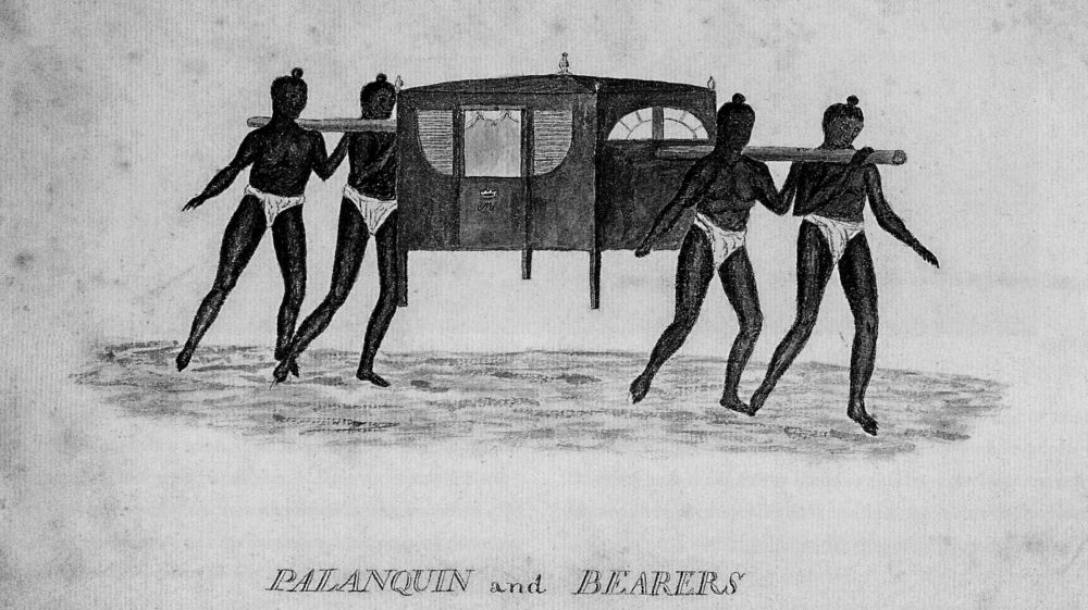
Fig. 9. William Haswell. Palanquin and Bearers. Logs of the Elizabeth, Charlotta, and Pallas, 1801–1803. Courtesy of the Phillips Library at the Peabody Essex Museum, Salem, Massachusetts.
Religion was perhaps the primary cultural characteristic the Salem voyagers saw as distancing themselves from the people they met. The Americans were fairly sophisticated about the distinctions between the religious practices of their various trading partners, even if ultimately they characterized all non-Protestant practices with the same pejorative adjectives. In India, they were aware of Hindu practices (which they called Jentoo or Gentoo). On Sumatra, Nichols observed “They are of the Mahometan Religion, but not very Superstitious, excepting in the food of which they are very much.”45 William A. Rogers noted that just north of the Malabar Coast he “Passed Mangalore, seaport of some importance . . . Inhabited by Gentoos and Mahomeddans. The Gentoos on their festivals carry their idols in triumph in a wagon, to the wheels of which are affixed crooked iron hooks, on these they throw themselves and are crushed to pieces.”46
And there was always a good measure of anti-Catholicism. Bowditch observed, “There are great numbers of Chinese at Manilla, but they are all obliged to become catholics.”47 George Nichols thought that if Madeira were “Inhabited by any other People than Portuguese it would produce, exclusive of the Wine, every Necessary of Life, instead of which they are dependent upon other Nations for almost every thing they want. I think this might be remidied by banishing the greater part of the many Priests & Friars, who serve only to oppress the Inhabitants & encourage Indolence.”48
In most instances, trade went smoothly. In Sumatra, Dana reported “in these excursions we always met with the utmost attention & civility from the Inhab,” which he attributed to American manners and honesty: “Probably that if we had treated them as Europeans in general are disposed to treat the meaner Casts of the Inhabitants of India we should not have had these priviledges & many others.”49 Dana showed unusual sensitivity to his trading partners’ perspectives: “Sometimes traders get into a quarrel with the natives by the frauds used in their dealings with them. The natives do not easily forget it but embrace the first opportunity of doing themselves justice.”50
The illustrations and written descriptions in the otherwise prosaic ships’ logs provided a way to share cultural as well as geographical information as Salem mariners developed Asian and Pacific trade. Personal global experience helped develop American commercial networks.
Language of the Picturesque
Describing landscape was an everyday activity for ships’ journal keepers. On the open seas they were required to record the weather, the currents, and the stars that helped them plot their location. As they approached land they described in words and images the coastal features. Most of the time, their images primarily reflected geographic and topographic traditions. But the late eighteenth century was also the time when picturesque traditions of landscape representation became widespread in the Anglo-American world. Salem mariners were well aware of representation in both topographic and picturesque traditions and incorporated aspects of both into their drawings.
A brief look at merchants’ and mariners’ reading on aesthetics, as revealed by their charge records at Salem’s Social Library provides insights into their artistic knowledge and level of sophistication.51 Many members read Edmund Burke’s philosophical treatise on the fine arts in the Sublime and the Beautiful, or Robert Dossie’s analysis of the commercial potential for applied arts in Handmaid to the Arts.52 Fresnoy’s Art of Painting circulated, as did Nugent’s Grand Tour.53 Both of these provided Salem readers with education in classical and Renaissance arts. However, the most popular book on the arts in Salem was William Hogarth’s Analysis of Beauty with its companion folio of plates, which was checked out by sea captains Jacob Ashton, William Cabot, and James King among others.54 Rather than a history of arts or compilation of significant architectural sites, Analysis of Beauty provided a method of understanding the formal qualities of art and appreciating visual experience. Books on aesthetics and applied arts were held at other Salem libraries as well. Thus Salem mariners had many opportunities to become familiar with modes of representing landscapes.
Sometimes the aesthetic sophistication of a voyage’s log keeper can be seen in his writing. Captain Benjamin Hodges, for example, kept track of the weather on his voyage to China as master of the William and Henry. Most entries are routine: “fair,” “pleasant,” “hot.” Some are more elaborate, but still primarily descriptive, as the day the ship was loaded and ready and stalled in Salem harbor waiting for an auspicious beginning:
Coald & much snow the Wind Northe
Lying at Anchor in Misery Harbour
at 6 AM Weighed Anchor & came to Sea
the Wind NNW a large swell from ENE
& very Coald55
But rare entries described the weather in more curious and aesthetic terms. As he approached Sumatra, Hodges noted: “Light winds & squally weather the water much discolloured but no bottom--- Middle part light breezes & Calm Lay by the Night, the Sea covered with Luminary Particles which in Washing decks covered them in a Romantick maner, on examination we found them to be small pieces of (Gilly) round the size of small bird shot.”56
Sometimes the men commented on the beauty of the landscape, including their native land. Leaving Salem harbor for a Boston departure to Bombay, William Rogers recorded: “I had an opportunity of witnessing the beauty of the scenery for which the entrance of the port is so justly celebrated. It was a most delightful morning and nothing could have interrupted the enjoyment of the view which would have enriched the imagination of a Vernet.”57 Later, appreciating the beauty of Ceylon and the coast of India, Rogers “took sketches as I passed along.”58 George Nichols was also impressed with Ceylon: “in sailing this Coast, the land had a beautiful appearance, being very level & quite covered with Coconut Trees.”59 Nichols was delighted by Madeira:
The best Season for visiting the Island is in the Summer when the weather is always warm and pleasant & the Isld under a State of Cultivation. I never was more pleased with any place although it was in the Winter Season all the Time of my being there. from the Roads you have one of the finest prospects imaginable; the great number of handsome Seats rising one above another almost to the summit of the highest mountains (which are frequently lost in the clouds) together with the beautiful verdure which appeared upon every part.60
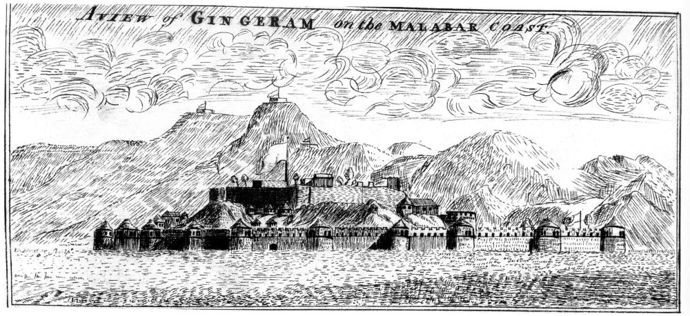
Fig. 10. Benjamin Carpenter, A View of Gingeram on the Malabar Coast. Log of the Hercules, Salem to Calcutta, 1792–1793. Courtesy of the Phillips Library at the Peabody Essex Museum, Salem, Massachusetts.
“One of the finest prospects.” With this phrase Nichols reveals his familiarity with the language of landscape aesthetics and the picturesque.
The illustrations that Benjamin Carpenter drew in his journals demonstrate familiarity with picturesque conventions of landscape. A small drawing that he labeled A View of Gingeram on the Malabar Coast illustrates the journal Carpenter kept in 1792–93, when he went to Calcutta as commander of the ship Hercules (fig. 10). Born in 1751, Carpenter was a career merchant mariner who engaged in sea trade from before the Revolution. He was among the first captains to go to Asia after direct trade began in 1784; and, since he also served in the role of supercargo on other voyages, he had a sharp eye for commercial possibilities in addition to maritime skills.61
Carpenter’s Gingeram is a phonetic transcription of Janjira. The island fortress Janjira was legendary for remaining unconquered—first repelling rival Asians, then later attempts by the Portuguese, Dutch, French, and English. Said to originate in the fourteenth century, it was fortified and shaped into its present form in the seventeenth century. The structure towers ninety feet above the sea, with thick stone walls rising more than forty feet directly out of the sea at high tide. There are nineteen rounded bastions heavily armed with cannon, connected by a rhythmic line of dark windows piercing a crenulated horizontal battlement. The fort’s interior held a palace, mosque, and deep well for access to fresh water.
Though the island is sited about a mile out to sea, there is little in Carpenter’s drawing to suggest that the fort is surrounded by water. The space is compressed and the fort reads as connected to the hilly shore rather than isolated by the sea. The landscape is constructed from a highly decorative series of lines; these hatchings change direction as needed to suggest sunlight and shadow on the planes of the architecture and landscape elements. Bursts of circles that make up the clouds animate the sky and lighten the ominous mood of the fort standing guard over the bay.
Carpenter’s drawing style seems to embrace picturesque ideas of balance. He plays against each other the light and the dark, the organic and the geometric, the moving and the still. The stylistic approach of the drawing seems to echo the linear treatment Carpenter would have seen in the engravings that accompanied the many illustrated voyage narratives that circulated in Salem. While some fine engravings, such as the La Pérouse title page (fig. 1) are built from barely discernible lines and stipples that read as tonal areas, other engravings retain the prominence of their linear components. Though Carpenter seems not to have had the classical training nor belonged to subscription libraries as other sea captains did, he would have had exposure to aesthetic and classical ideas through his very active participation in the civic life of Salem. Along with Hodges and many other sea captains, he was a member of the Essex Freemasons, a member of the Salem Marine Society, and a founding member of the East India Marine Society to which he donated several significant items. His landscape drawings, executed in a style easily readable because its visual language derived from widely accessible engraved illustrations, made his first-person accounts more vivid for his brother mariners.
As the title page of La Pérouse’s atlas illustrates, geographic and cultural representations in both words and images transmitted global knowledge—which was essential for trade and wealth in seaports such as Salem. Access to this knowledge became a bond that formed and united an elite class of merchants and mariners. Visual culture played a significant role in circulating this information, in both print and manuscript. Visual culture was essential to the transmission of information along personal networks, which were established various ways—through kinship, business relationships, membership in social or professional organizations, or other venues that were gradually becoming more institutionalized in the Early Republic. Salem’s mariners both collected and created visual representations, and shared them along these dense and interconnected networks for their mutual benefit and that of American commerce.
* * * * *
I thank Martha McNamara, Georgia Barnhill, Jessica Lanier, Emily Murphy, Joanne Lukitsh, and Josilyn DeMarco for their comments on earlier versions of this essay. I am also very appreciative of the research librarians who suggested sources and located specific editions of books known to have circulated in Salem, particularly Jean Marie Procious and Gus Sousa of the Salem Athenaeum, and Barbara Kampus, Kathy Flynn, Irene Axelrod, Andrew French, and other librarians of the Phillips Library of the Peabody Essex Museum. I also thank members of the Salem State University Academic Writers Group: Peter Walker, Elizabeth Kenney, Avi Chomsky, Nancy Schultz, and Elizabeth Blood.