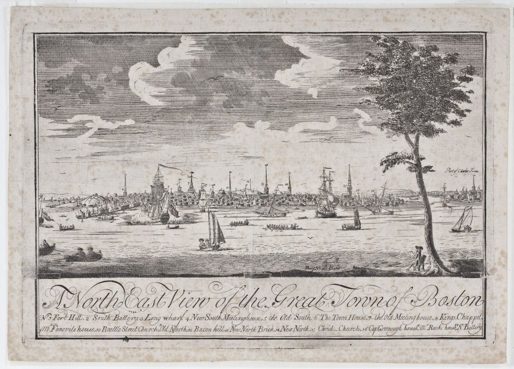
Fig. 1. Attributed to William Burgis, A North East View of the Great Town of Boston. London, ca. 1723. Photograph Courtesy of the Peabody Essex Museum, Salem, Mass. Object ID #1163.
Navigation, Vision, and Empire: Eighteenth-Century Engraved Views of Boston in a British Atlantic Context
KEVIN MULLER
IN THE WINTER and spring of 1722–23, an enticing series of advertisements appeared in the Boston-based New England Courant. Addressed to the gentlemen of the town, these notices informed readers of plans afoot to publish a view of Boston taken from the vantage point of Noddles Island, that is, from a position to the northeast looking back across the harbor towards the town.1 The proposed engraving would be based on a drawing by William Burgis, a relative newcomer to Boston, who at various times in his life identified himself as a draftsman, painter, and innkeeper.2 His drawing, the advertisements explained, was available for inspection at William Price’s Map and Print Shop. Those who found it to their liking were directed to Thomas Selby’s Crown Coffee House, located a few short blocks from Price’s establishment, where subscriptions for its publication were being taken and, incidentally, where Burgis was then lodging. Upon completion, the print would be available for purchase at Price’s shop. Soliciting subscriptions for a print was typical for the time, even in London where a much larger print market existed, because it helped those producing a print judge whether enough public interest existed to warrant the expense of publishing it.3 In the case of the Boston view, the cost would have had to cover the expense of Burgis’s handwork, and of sending Burgis’s drawing to London to be engraved, as was noted in the advertisements.
Evidently enough gentlemen did subscribe, because in December of 1723, an advertisement announced that the print was available for purchase at Price’s shop (fig. 1)4 The medium-sized engraving (measuring 9½ inches by 12¾ inches) offers a sweeping prospect of Boston from Fort Hill on the left to Charlestown on the right. The spires of the town’s important buildings are silhouetted against the horizon, each numbered and identified in the print’s legend, as are the masts of several sailing ships. These ships, along with other, smaller vessels, either ply the placid waters of the harbor or rest at anchor. Under a tree in the foreground, an artist, perhaps Burgis himself, sits sketching. Compositionally, Burgis organized the scene according to the familiar conventions of picturesque landscapes by seventeenth-century French painters such as Claude Lorrain and Gaspard Poussin, with a low horizon line, clear back-, middle- and foregrounds, the use of repoussoir (the tree to the right that helps establish a sense of spatial recession) and foreground staffage (the small figure sketching).
The team of Burgis, Price, and Selby must have had high hopes for this print, because it was among the first views of Boston ever engraved. However, they soon came to realize their subscribers wanted a decidedly different view. In the same notice advertising the sale of the completed northeast view, plans for a second print were announced.5 This view would depict Boston from the southeast, perhaps from Governors, Bird, or Castle Island (although no specific location was noted). Once again Burgis made a drawing, it was displayed at Price’s shop, Selby took subscriptions, and the print was engraved in London.6 In August of 1725, Price advertised that this second Boston view was now available for purchase at his shop.7
Like its predecessor, this “New and Correct Prospect”—as it was identified in the advertisements—offered a view of Boston from across the waters of Boston Bay, taking in the broad sweep of the opposing shore. As per the printsellers’ indication, however, the viewpoint is now shifted to the south so that Long Wharf is centered in the composition and Charlestown no longer pictured (fig. 2). Also like the first print, this second image includes specific architectural landmarks that are numbered and identified in a legend, although many more structures are now included. The second print is also much larger than the first, measuring an impressive 24½ by 52½ inches, so large that it needed to be printed with three separate plates. But where the second view diverges most noticeably from the first is in its composition. This scene is not organized according to the landscape conventions of the picturesque. Gone are the first print’s low vantage point, framing foliage, orderly recession of space, and scale-establishing foreground figure. Instead, the second view is seen from an elevated position hovering somewhere out and above the waters of Boston harbor, an effect Burgis achieved by eliminating landmasses from the foreground, positioning the horizon nearer to the top of the frame, and dramatically foreshortening Long Wharf, so that it thrusts precipitously down and to the right. Also different from the first view are the second’s inconsistencies in scale and perspective, which suggests it to be a composite scene, created from at least two distinct vantage points.
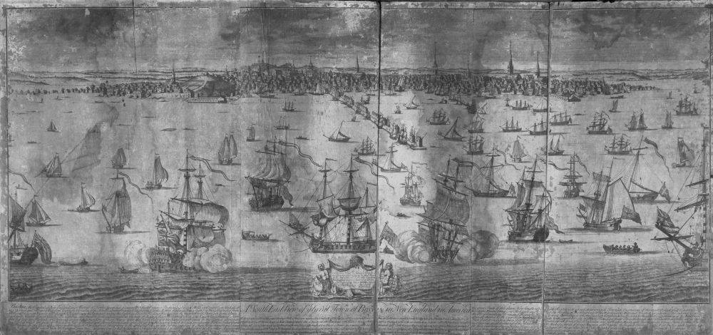
Fig. 2. John Harris after William Burgis, A South East view of ye Great Town of Boston in New England in America, London, 1725. I. N. Phelps Stokes Collection, Miriam and Ira D. Wallach Division of Art, Prints and Photographs, The New York Library, Astor, Lenox and Tilden Foundations, New York, N.Y.
Of the two views produced by Burgis, Price, and Selby, the earlier version was neither reprinted nor repeated by later colonial artists. Moreover, its present-day rarity—only one copy is known to exist—suggests few were ever printed.8 By contrast, the second, larger view was evidently more popular; it was reissued, with updates, in 1736 and 1743, and later colonial artists are known to have used Burgis’s new compositional approach, depicting the town from a similarly elevated vantage point.9 James Turner’s simple engraving for the headpiece of The American Magazine and Historical Chronicle presents the town with Burgis’s bird’s-eye view (fig. 3), and Paul Revere, in his 1770 engraving (fig. 4), likewise places the viewer high in the air, looking out towards the town and down onto Long Wharf, where British troops can be seen disembarking. Only in the decades following the American Revolution did artists change their point of view and their aesthetic, returning to picturesque landscapes seen from eye level. However, these post-revolutionary artists now used an inland vantage point, planting their viewer firmly on American soil.10 Thus the elevated view from a point east of Boston was meaningful for Bostonians during those years they defined themselves in relationship to—and loyal to—lands in the east. In other words, Burgis’s southeast view was meaningful to Bostonians when Bostonians were British.
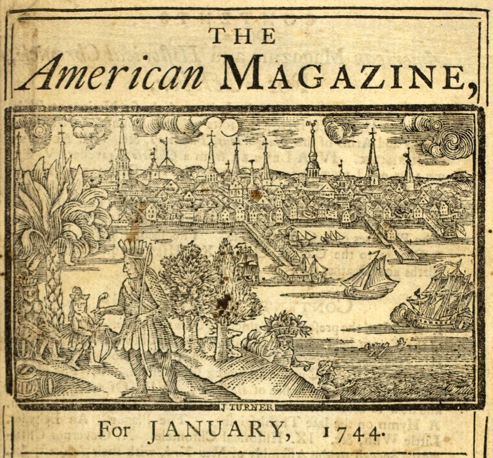
Fig. 3. Headpiece engraved by James Turner from The American Magazine and Historical Chronicle, Boston, 1744. Courtesy, American Antiquarian Society, Worcester, Mass.
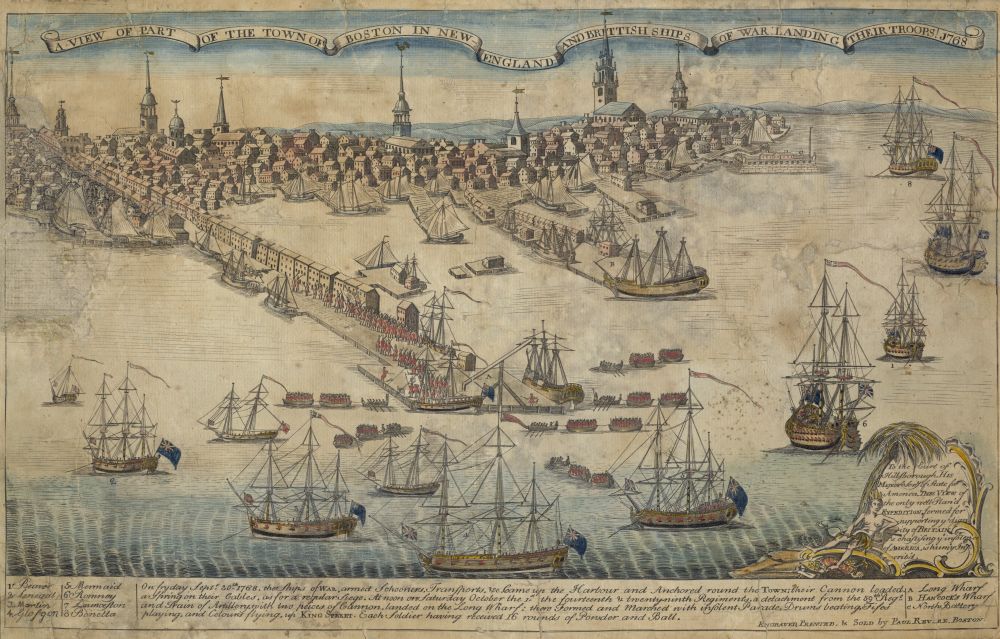
Fig. 4. Paul Revere. A View of Part of the Town of Boston in New-England and Brittish Ships of War Landing Their Troops! Boston, 1770 Courtesy, American Antiquarian Society.
To date, scholars have rightly interpreted this print as a document of early Boston’s changing urban topography, as an expression of civic pride, and as a visual manifestation of a mercantilist ideology.11 What has been left unanswered by these approaches, however, are questions surrounding the circumstances of the print’s production, how those circumstances shed light on the print’s intended audiences, and finally, how the print served to forge a sense of local and transatlantic identity. Based on where the print was advertised and sold, we can conclude its primary audience was Boston’s merchants. How this fact affected Burgis as he shaped his southeast view has not been analyzed, to the detriment of our understanding of this print. I argue that, in targeting merchants, Burgis designed his document to speak explicitly to them, first by fitting it to their particular skills of gleaning data from pictorial sources, and second by fitting it to a merchant’s particular worldview. As to the first point, regarding the unique visual literacy of merchants, Burgis’s composition actually mirrored the mechanics of a specific type of pictorial document, one familiar to merchants: sea charts. Early modern sea charts represented a visual culture of and for merchants (among others) and a close analysis of Burgis’s composition reveals the logic of such charts underlie the southeast view’s elevated viewpoint. As to the second point, regarding the merchants’ worldview, I argue that the print’s high, southeast perspective—that of a disembodied eye approaching Boston from a point east of its harbor—encoded a certain east-west duality that would have been evident to merchants. This dual subjectivity allowed merchants, more than others, to locate Boston, and by extension themselves, within the larger maritime geography of the British Atlantic. Even more, it allowed merchants to see themselves as both subjects and creators of the British Empire. Although this dual subjectivity was not originally available to all viewers, I argue that, eventually, the format of the southeast view came to stand for all of colonial-era Bostonians’ collective view of themselves, because in the end, it could accommodate the subject positions of different viewers who, though perhaps not merchants themselves, shared a similar understanding of the mechanisms of empire.
The advertisements Burgis, Price, and Selby placed in the New England Courant, specifically solicited subscriptions from the town’s “gentlemen.” Where Burgis’s drawing was put on display for examination, where subscriptions were taken, and where the print was sold, suggest that the category of “gentlemen” the publishing team sought consisted primarily of the town’s merchants. The New England Courant was a Boston-based publication that included local and overseas news and listed vessels arriving into and departing from Boston Harbor.12 Price’s print shop, where Burgis’s drawings were displayed, was located on King Street near the Townhouse, a focal point for merchant activities (the Townhouse is the structure above the lower case “a” in fig. 5)13 Merchants met at the Townhouse daily to share the latest local, regional, and international news and negotiate financial instruments. Price’s nearby shop was part of the merchants’ information network, a place where they could purchase maps and sea charts, both of great importance to maritime commerce.14 Thomas Selby’s coffeehouse, where subscriptions were taken, was located further down King street, at the foot of Long Wharf, and was also a haunt of local merchants, where Selby’s food and drink helped lubricate the agreements they struck with seacaptains, shipowners, and each other.15 It was at Selby’s that merchants could have spoken to Burgis directly when they subscribed to the first print, and it was there we can imagine they encouraged him to do a second view, one representing the town and its harbor from their own perspective.
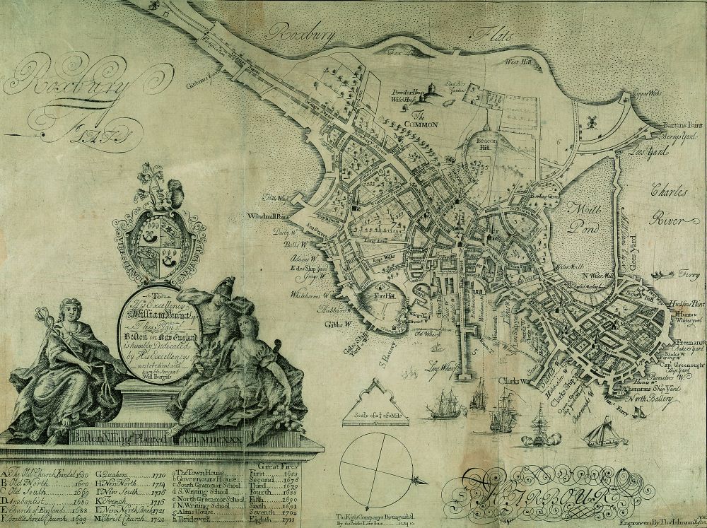
Fig. 5. William Burgis. To His Excellency William Burnet, Esqr., this plan of Boston in New England. [Boston: Sold at the Crown Coffee House, 1728]. Detail. Boston Athenaeum, Boston, Mass.
Burgis, Price, and Selby were right to target Boston’s merchants as their primary audience. Merchants possessed the capital needed to subscribe to the southeast view, and they possessed a desire for the information it presented. As historian Phyllis Hunter has shown, starting in the late seventeenth century merchants began to displace Puritans from positions of authority in New England port towns, and with them brought an ethos of capitalism.16 While the success of individual merchants depended on a number of personal factors, the collective rise of merchants in the eighteenth century throughout the British Atlantic stemmed also from the very nature of the British Empire.17 Today, the term “British Empire” invokes thoughts of colonial territories ruled by and subordinate to a central authority located in London, but this framework really only characterizes the British Empire of the nineteenth century. During the late seventeenth and for much of the eighteenth century, Britons living in North American colonies and elsewhere in British-controlled areas understood themselves as citizens of an empire defined more by commerce and trade than by the authority of the Crown or Parliament in London. Moreover, the empire in which they lived was primarily Atlantic in its geographic scope. Key figures in the creation and maintenance of this commercial empire were merchants. Essentially middlemen who organized trade between ports spread out across the Atlantic, merchants not only employed a range of producers, processors, and transporters, they more importantly satisfied consumers’—and their own—growing demand for the most recent and fashionable goods.
As Hunter also shows, starting in the late seventeenth century, New England merchants began to supplant Puritan values with a culture of gentility.18 Given the growing consumption of objects that signified gentility, especially among Boston’s elite, Burgis, Price, and Selby were right to create their first view of Boston according to picturesque conventions. In the 1720s, the picturesque aesthetic was coming into vogue as a signifier of a genteel sensibility, as elites in England began to appreciate and prefer landscapes rendered according to the picturesque conventions found in the paintings of Lorrain and Poussin.19 Perhaps Burgis, Price, and Selby believed the time was right for a picturesque view of Boston made to appeal to local gentlemen who took their cultural cues from their Georgian counterparts in England. That Boston merchants ultimately rejected the picturesque northeast view in favor of the pictorially challenging view from the southeast, and that the latter had such longevity up until the time of the American Revolution, suggests that even as colonial merchants aspired to gentility, and surrounded themselves with the markers of it, they also desired a visual culture that spoke their language—a language associated with their own success in Boston—and one that, importantly, enabled them to claim their place within the local hierarchy, as well as that of the burgeoning British Empire.
This unique visual language is the distinguishing feature of the southeast view, and is that which most dramatically differentiates it from its predecessor. How it spoke directly to merchants was in its reliance on the visual mechanics of early modern sea charts. Like these sea charts, the southeast view represents Boston from more than one vantage point. Indeed, whether the print is hung on a wall like a painting or laid on a table like a map, the viewer cannot but help find his or her focus pulled in two different directions: out towards the town and down onto the vessels that fill the harbor below. These two viewing positions roughly correspond to what we today commonly call plan view and elevation view. In the former, an image functions like a map, representing the contours of its subject from above, from a bird’s-eye view looking downward. In an elevation view, by contrast, an object is represented as if seen from ground level so as to reveal its height, width, and profile. Plan and elevation views are familiar to anyone who studies architectural renderings of buildings, for buildings must be presented in both formats to be fully comprehended in two dimensions. But plan and elevation views of buildings are presented separately, while in early modern sea charts, the contours of coastlines seen from above, and their elevations as seen from shipdeck, are often presented simultaneously. In the southeast view, Boston and its surrounding environs are represented more or less in elevation view, from a lowered position, allowing the unique features of both the townscape and the surrounding landscape, such as the church steeples and hills, to appear more or less in profile. Yet the shoreline and the wharves are represented from a much elevated vantage point, as in plan view. As a result, the distinct skyline profile of 1725 Boston is clearly visible, but so are the undulations of the shoreline and the position and relative sizes of the town’s various wharves—features that could only be accurately discerned from above. All can be readily comprehended in Burgis’s southeast view. Such is the logic of the sea chart, combining in a single document the world seen both by a ship’s captain and by the gull hovering high above his head. Because the southeast view combines these two distinct viewing positions into a single image, however, we see neither a true elevation of the distant landscape nor a complete plan of the harbor, and as a result, the beholder’s viewing position continually oscillates between looking out and looking down.
For modern viewers, this viewing experience may seem awkward, even illogical, but it was quite familiar to eighteenth-century merchants, because of their use of sea charts and their knowledge of the processes of navigation. While merchants were themselves mostly land-based, many had been taught the fundamentals of navigation by tutors, and many sailed aboard family-owned vessels as a form of apprenticeship.20 Some even captained vessels themselves.21 Thus they knew from firsthand experience that successful navigation at sea requires two distinct kinds of visual information: the plan and elevation views of the coasts to which they traveled.22 By mentally combining overhead views of the contours of landmasses with eye-level views of what one should expect to see from the deck of one’s vessel, a mariner could reasonably establish where at sea he was located.23
Early modern sea charts were a unique form of navigational visual culture that combined both plan and elevation views into a single image. Collections of sea charts, known as sea atlases, were first published in great number by the Dutch, starting in the sixteenth century.24 However, as Englishmen took to the seas in ever greater numbers over the course of the seventeenth century, English publishers, most notably John Seller, began to provide such dual-focused charts for his seagoing countrymen in English language sea atlases.25 For example, John Seller’s 1675 Atlas Maritimus included a chart for the Cape of Good Hope that combines plan and elevation (fig. 6). The bottom two-thirds of the chart presents the coastline as seen from above, as in plan view, yet upon careful examination one sees the coast contours are actually outlined with hills and mountains as they would be seen from out at sea. The top third of the chart is a detailed view of the topographical features that surround Table Bay as seen on approach from the sea, thus in elevation view, yet the vantage point is elevated in order to show the viewer the shape of the harbor and important anchorage sites in relation to these topographical features. By combining plan and elevation views, Seller’s chart thus enabled a mariner to know the specific land formations that would be visible as he sailed along this portion of the African coast and into Table Bay. Not all charts included multiple views; those that did usually represented coastlines the shape of which were not self-evident when viewed from sea level and thus were difficult to navigate. However, by combining both plan and elevation information together, sea charts could be used reliably for navigating such shores, allowing sea captains to situate their vessel in relation to particular bays and harbors. He could also understand his position within a larger geography, one either implied by the scope of an entire atlas that covered a specific region or, more practically, one implied by the context of the voyage. For example, upon viewing the chart of Table Bay, the mariner could position himself along the African coast and/or at a point in a longer voyage, perhaps one from England to India.
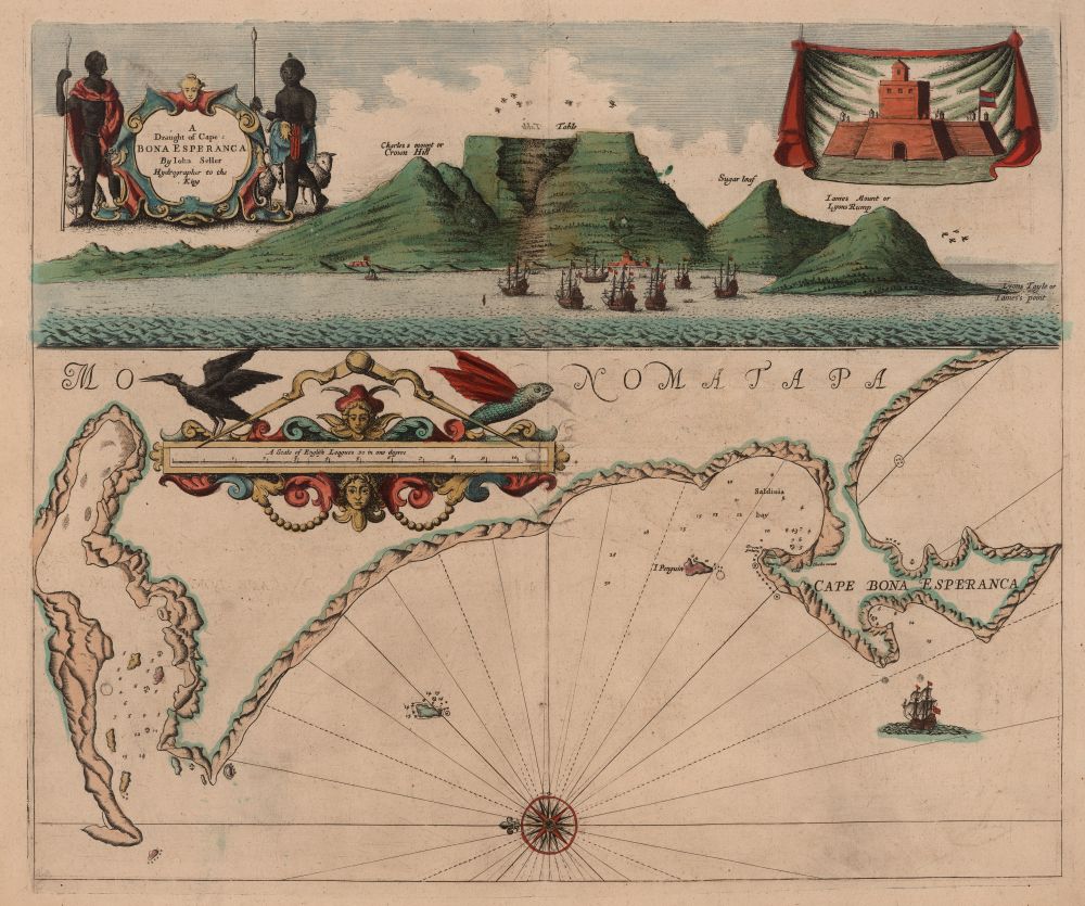
Fig. 6. “Chart of Cape Esperanza” from John Seller’s Atlas Maritimus. London, 1675. Courtesy of the John Carter Brown Library at Brown University, Providence, R.I.
Although the images in early modern sea charts were functionally useful, they are no longer part of our visual culture. The charts and images published in Seller’s atlases were plagued with inaccuracies, so much so that in the eighteenth century the English Admiralty took to sponsoring the creation of more accurate documents, which in turn required more precise surveys of coastal regions and a more accurate method of indicating coastal features.26 As a result, by the late eighteenth century, Seller’s type of sea chart more or less disappears, in large part because a regular system for rendering topographical features, most notably contour lines, had been developed. Mariners could now examine a chart that was executed entirely in plan view and create an accurate navigational elevation in his mind’s eye from wherever his location offshore. However, for much of the seventeenth and eighteenth centuries, dual-focus sea charts were among the primary visual tools available for planning and sailing voyages to unknown coasts and harbors. Land-based scholars tend to overlook the substantial importance of sea charts, perhaps because the advent of radar and global positioning satellite systems have led us to forget their use. But they were the key tool of seventeenth- and eighteenth-century navigation, and therefore of commerce, and thus they were of real familiarity to Burgis’s audience of merchants.
It would appear that when the merchants of Boston encouraged Burgis to create a second view of their town, they did so because they wanted an image that would allow them to see themselves and Boston from their own perspective, which is to say, from a navigational perspective. Indeed, the southeast view can be read in ways similar to Seller’s chart of the Cape of Good Hope. In elevation, the hills and townscape identify a landfall in profile that is recognizable precisely because Boston was like none other. In plan, the anchorage spots and shoreline facilities are visible, especially Long Wharf. With its space organized like a sea chart, the southeast view encouraged its merchant-viewers to locate Boston within a larger set of transatlantic coordinates, one of a network of ports and harbors scattered around the Atlantic, a geography merchants knew well from studying maps and charts and directing sea captains in their employ to particular destinations.27 In fact, the Burgis, Price, and Selby print explicitly reinforces a conceptualization of Boston within a broader imperial geography, as its text asserts by noting that the town is located “in the Latitude of 42 and 24 [degrees] North, and 71 Degrees West from London; the variation of the Needle about 9 degrees West.” In other words, according to this print Boston existed only in relation to the fixed coordinates of London.
Burgis’s use of a high, hovering, and disembodied eye gazing upon Boston town from a point east has another significance, however. Consider for a moment a merchant-viewer scrutinizing the print at Price’s print shop. This merchant would have had the uncanny experience of looking back on himself, as his vision was directed along the receding Long Wharf and back to the Townhouse, the print’s focal point and precisely where he was presently standing. At this moment, our merchant was simultaneously the observer and the observed. Like the print’s double vantage points of looking out and looking down, this dualistic viewing position is also somewhat unstable, as this viewer could not help but oscillate between the two positions of watching and being watched. However, this duality and instability was important for the merchant-viewer, because it ultimately corresponded to his roles as simultaneously both subject and creator of the British Empire.
In seeing himself as observed, the merchant-viewer adopted the viewing position of the imperial administrators who oversaw the colonies from a distance and regulated the workings of the empire through laws and statutes that affected the merchant’s everyday life. The most important of these were The Acts of Trade and Navigation.28 These series of laws and statutes were implemented by Parliament in the second half of the seventeenth century and were designed to standardize transoceanic trade in lands under British sovereignty, as well as those simply under British control. They effectively made possible the maritime empire in which Boston’s merchants operated because they put into place a relatively level playing field for all British citizens engaged in trade, regardless of where they lived, their religion, or their ethnic affiliation (although location, kin, and religious ties could be advantageous). The system known as mercantilism subsequently developed, whereby colonies shipped raw materials, in British-owned vessels, manned with mostly British crews, to Britain in exchange for manufactured commodities. Little direct trade was permitted with the foreign powers; instead, all raw materials and finished goods had to first pass through British ports. In addition to trade between Britain and her colonies, an extensive lateral trade developed, most notably between New England and the West Indies, but also between different ports located around the Atlantic. Because handsome profits could also be made by smuggling—a vocation at which many Boston and New England merchants excelled—Parliament and the Crown placed customs officials and other officers in major ports to keep an unwavering eye on the activities of merchants.29
The merchant-viewer of Burgis’s print would have been reminded of this administrative presence, this ever-gazing eye, by the clustering of British men-of-war in the print’s foreground. These large ships can be identified by their three-masted rigs, flags, pennants, gun portals, and elaborate hull decorations.30 The center ship, identified in the print’s text as the “station ship,” is a type of naval vessel commonly found anchored in colonial ports for defensive and administrative purposes.31 But in addition to defense, this naval presence also served to deter smuggling, which, lucrative though it may have been for New England merchants, did not serve the good of the empire. Indeed, as a result of the viewer’s elevated vantage point, the naval ships in the print’s foreground show the intimidation meant by their placement, forming as they do a kind of gate to the harbor, regulating the passage of merchant ships as they sail to and from the town.
If the elevated viewing position of the print enabled merchants to see Boston, and themselves, as subject to an imperial administrative surveillance, this viewing position also, and perhaps more importantly, allowed merchants to see themselves as playing an important role in the creation of this empire. They could look upon the town as a product of their own creation and values, the result of hard work and prosperity that had enabled them to physically shape the town’s urban topography.32 While most of Boston’s smaller domestic and commercial structures are rendered generically, some forty-seven specific structures associated with merchants are accurately delineated, numbered, and described in the legend below.33 For example, amidst the jumble of houses hugging the distant hilltops, several well-to-do merchant’s homes are pictured, including that of Andrew Faneuil.34 Equally prominent along the town’s skyline are structures associated with a range of Christian faiths, including the Quaker Meeting House, the Anabaptist Meeting House, and the Anglican King’s Chapel. These too speak to the power of Boston’s merchant’s class, whose ethos of capitalism transcended religious difference, thereby cultivating religious diversity.35 In fact, the construction of many of these houses of worship had been financed by local merchants.
The same is true of the many commercial structures made visible by Burgis’s lifted perspective. Many of these carefully rendered buildings had been funded, directly and indirectly, by merchants, helping to make Boston a prosperous port town. The shipyards, too, pictured along the shoreline, were essential for the success of Boston’s commercial life. Here local merchants commissioned shipwrights to build vessels according to specifications based on needed cargo carrying capacity and intended ports of call.36 The print’s text underscores the success of Boston’s shipbuilding industry, explaining that in the year 1723 over 700 ships had been built in the town’s shipyards.37 The most prominent and unique commercial structure pictured is Long Wharf. Measuring an impressive 1800 feet long (nearly one-third of a mile), Long Wharf was used to dock ships of great burden and draft so their cargos could be transferred directly to and from their holds and into one of the over fifty warehouses built along the wharf’s length.38 Completed in 1710, its construction had, perhaps predictably, been financed by Boston’s merchants, who also owned the warehouses located on it and, we can imagine, many of the ships tied alongside. As the print’s text also notes, in the year 1723 an impressive 1000 ships annually cleared its harbor (that’s more than three each day) destined for England and the West Indies laden with cargos of forest, sea, and agricultural products.39 Returning vessels brought desired manufactured goods and (hopefully) profit for the merchants who organized the voyage, which had enabled them to build the city in their image. Thus, Long Wharf, and the other wharves projecting from the shoreline, facilitated the prosperity of Boston.
Merchant-viewers of the southeast print would have also looked upon the many vessels pictured in the harbor with interest, which explains the care Burgis took in their rendering. Boston was home to a variety of sailing craft, because its merchants shuttled mixed cargoes to different ports around the Atlantic, each port possessing different harbor conditions and facilities.40 Due to these challenges, a diverse fleet was necessary in order to knit the empire together through maritime trade. Boston merchants would have easily recognized the types of vessels depicted by Burgis, for example the small, single-masted sloops pictured throughout the harbor.41 Because merchants often commissioned ships from local shipwrights according to requirements determined by intended cargo and potential ports of call, they were highly sensitive to their design, construction, and function.42 They could easily have inferred the kind of voyages the vessels pictured in the harbor would be undertaking. They would have known that the sloops were ideally suited for coasting, that is, for navigating within the sight of land, because their fore-and-aft rigging, which has sails set in line with the keel of the boat, meant they could be confidently skippered along landmasses where the wind direction shifts regularly as a result of irregular landforms and offshore breezes.43 As a result, sloops typically voyaged from Boston north to Maine and south to the West Indies.44 They would have inferred similar information upon seeing the three-masted, square-sterned frigate to the right of the men-of-war (and elsewhere in the print). Frigates, unlike sloops, carried sails on spars, which are set perpendicular to the keel and thus sail best with a strong and consistent wind blowing from astern. For this reason they were typically sent on long-distance transatlantic routes, such as Boston to London or Bristol and back again.45 As a result of knowing the kinds of voyages different vessels were designed to make, Boston’s merchants looking at the southeast view could imaginatively connect the town to other ports in the Atlantic through the journey of specific ships, and thus see in the print the activities that ultimately created the British Empire.
If in the 1720s the primary audience for the southeast view was the town’s merchants, within two decades this format came to stand in for a more inclusive, collective portrait of the city and its inhabitants. In 1743, James Turner engraved the headpiece of The American Magazine and Historical Chronicle (fig. 3), an image that depicts Boston from an elevated vantage similar to that found in the Burgis, Price, and Selby print. This locally published magazine included within its pages a range of essays and articles on literature, science, politics, and the arts, interspersed with verses of poetry, all intended to make the publication appealing to a diversity of readers other than merchants.46 How was it possible that a view originally meant to encode the point of view of the town’s merchants came to appeal to a greater percentage of its citizens? The answer lies in the fact that the activities of Boston’s merchants brought together a range of producers and consumers who could share in their worldview and enjoy the nature of the empire they had helped create.47 Acting as middlemen, merchants purchased raw materials—furs, grains, fish, and lumber—from local New England suppliers. These commodities were then shipped, perhaps in a locally-built vessel, manned with a New England crew, to distant ports where they would be sold. A new cargo, possibly including agricultural commodities (sugar or molasses from the West Indies) and/or manufactured goods (Irish linen, Chinese porcelain, or furniture from London), was loaded onboard and the ship returned to Boston. These items were then purchased by local individuals who either processed particular commodities (for example, molasses was distilled into rum) or who simply sold the manufactured items (such as a porcelain tea set) directly to New England consumers. Thus, from start to end, the merchants of Boston required the assistance of many others, including producers, processors, handlers, and consumers of all kinds, who in turn stood to benefit from their activities. These minor, but in no way less significant players in the wheels of colonial commerce, could ultimately embrace an image that represented Boston as a prospering maritime empire because they too benefited as a result of merchant successes. As long as Bostonians saw themselves as citizens of a maritime empire, they could subscribe to this view of themselves and their town.
That the southeast view and its subsequent derivatives remained meaningful to Bostonians as long as they saw themselves as citizens of the British Empire suggests that this format was one that spoke to an imperial, rather than a national identity. Indeed, as we have seen, the format of these images drew on the visual culture and processes of early modern navigation, allowing merchants and then others to see Boston and themselves within large geographic and imperial frameworks that were ultimately maritime in nature. Given that merchants operated throughout the empire according to more or less the same procedures, and that maritime commerce structured the interaction between individuals and communities dispersed around the British Atlantic, it is perhaps not surprising that we find the same pictorial conventions used to depict other British port towns in the eighteenth century, for example, a 1712 engraving of Plymouth (fig. 7) and a 1719–21 print of New York (fig. 8), the latter also by William Burgis. These prints, and others like them, have generally been interpreted as part of a linear development of topographical views, a European landscape genre that has its origins in the fifteenth century and culminates with the nineteenth-century diorama.48 However, when seen in the geographic context of the British Empire, we find a surge in the publication of such prints starting at the end of the seventeenth century, and then an abrupt end to that surge at the end of the 1700s, about the same time that Britain’s empire shifts away from a maritime structure. While topographic in nature, I contend that these prints were meaningful for the inhabitants of these towns at this particular time in history for the same reasons that the Burgis, Price, and Selby southeast view was relevant to Bostonians for much of the eighteenth century. They allowed viewers to see themselves and their community within a maritime, imperial framework and did so precisely because the imagery of these prints was also predicated on the common-shared visual culture associated with early modern navigation.
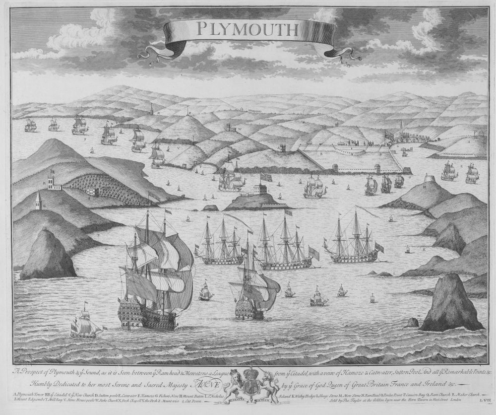
Fig. 7. Johannes Kip. “Plymouth,” plate 57 from volume two, part one of Nouveau Theatre de la Grande Bretagne. London: David Mortier, 1716. Yale Center for British Art, Paul Mellon Collection, New Haven, Conn.
Atlantic navigation remained important for all these individuals and communities well into the nineteenth century; however this pictorial format could not convincingly encode a maritime imperial framework once London became the imperial center of the British Empire. For Bostonians, that process began in the late 1760s and included the event depicted by Paul Revere in his aforementioned engraving (fig. 4). In 1768, the royal governor of Massachusetts requested that royal navy ships and soldiers be sent from England to Boston in order to reestablish the rule of law among the town’s citizens, who, as he saw it, refused to follow the instructions and orders of royal customs officials charged with enforcing the laws of trade.49 Two years later, Revere rendered the town and its harbor according to the familiar, dual-focused perspective established decades earlier in Burgis’s southeast view. However, instead of filling the fore- and middle-grounds of his print with merchants vessels, Revere replaced them with men-of-war, troop transports, and soldiers disembarking. If the merchant vessels included in earlier prints had enabled the citizens of Boston to understand themselves as both creators and subjects of the British Empire, this overwhelming presence of royal authority signaled that Boston’s place in the empire had changed. Bostonians now saw themselves as subjects, and as such could be punished like disobedient children for their transgressions by an imperial authority located across the Atlantic in London. When seen within the context of the pictorial tradition established by Burgis, representing merchants and the entire community of Boston as possessing agency and self-determination, the implications of this substitution must have been immediately clear to Bostonians, especially those who shared Revere’s politics. The events of the American Revolution ultimately shattered the imperial framework for Britain’s North American colonists, and in turn the pictorial paradigm established by the Burgis, Price, and Selby southeast view became meaningless. In the following decades, a new nationalist discourse emerged, one that coincided with renewed interest in the picturesque and emerging ones of the sublime, all of which encouraged Americans to turn to other pictorial strategies by which to render their landscape, and by extension, their own identity.
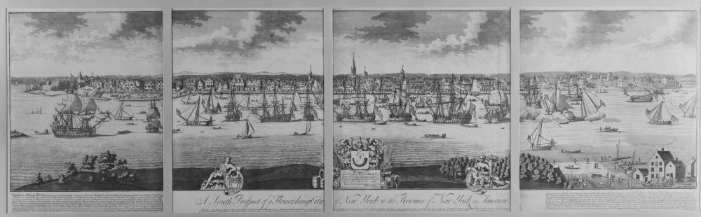
Fig. 8. John Harris after William Burgis, A South Prospect of ye flourishing city of New York in the Province of New York in America. London, ca. 1719. Print Collection, Miriam and Ira D. Wallach Division of Art, Prints and Photographs, The New York Public Library, Astor, Lenox and Tilden Foundations.
* * * * *
I would like to thank Georgia Barnhill, Martha McNamara, Eric Kimball, and especially Diane Zuliani for their helpful and constructive advice. This essay is part of a book-length study tentatively entitled Envisioned Communities: Colonies, Empires, and Visual Culture in the British Atlantic, 1600–1776.