Buildings, Landscapes, and the Representation of Authority on the Eastern Frontier
KEVIN D. MURPHY
IN HIS SEMINAL CONTRIBUTION to the New England Begins catalogue from 1982, Robert Blair St. George starts his article, “‘Set Thine House in Order’: The Domestication of the Yeomanry in Seventeenth-Century New England,” with the rumination that “Perhaps the historian’s persistent lack of attention to space is rooted in an unhealthy positivism. Space, after all, implies to the modern mind a kind of phenomenological absence.” St. George goes on to argue against such a conception of space and to suggest that indeed the very organization of the yeoman’s property—comprising his house, farmyard, and outbuildings—was “crucial both to his economic livelihood and to his psychological stability.”1 At the time of St. George’s writing, the extent and significance of the so-called “spatial turn” in cultural studies could scarcely have been imagined. Some of the texts that have been key to postmodern reconsiderations of the nature of space and its implications in social and political transformations had only just been published or had yet to appear, at least in English, and had yet to exert what would become their important influence on such fields as geography, social and political history, architectural history, and others.
Later in the 1980s, however, the writings of Henri Lefebvre, Michel Foucault and other North American and Continental theorists would profoundly alter the ways in which space was conceptualized.2 Space went from being generally thought of as an empty stage on which meaningful action might take place to being considered as something at once produced by knowledge and mobilized in relation to social struggles and other contests. Correspondingly, the system of perspective, in use since the Renaissance, could no longer be thought of as a neutral technique for representing three-dimensional space on a flat surface, but instead had to be considered as historically and geographically contingent, and its implications for the construction of an ideal, immobilized viewer had to be taken into account. Moreover, the ways in which buildings and landscape elements positioned viewers in relation to the objects of their “gazes” were increasingly considered in light of a general skepticism about the politics of sight, that is to say, as a consequence of a new attentiveness to the power relations embedded in the act of looking itself.3 These intellectual developments of the last twenty-five years make it possible to pursue St. George’s suggestion, made in New England Begins (and as he himself has done subsequently), to consider how space, rather than acting as a neutral ground devoid of political importance, was instead constructed through social interactions and became a site for self-fashioning as well as for social and political positioning.
While St. George transformed our understanding of the landscape of seventeenth-century New England, his insights can apply to other places and times where the spatial turn offers some interpretative models that might be applied to familiar objects, in this case, the eastern frontier of northern New England during the Early Republic, and particularly the District of Maine prior to its separation from Massachusetts in 1820. Specifically, I would like to consider how the shaping of the natural and built environments, as well as some early representations of that process, were intended to fix social relations in a period of considerable struggle. Further, I would like to evaluate—to the extent possible given the character of the historical record—how efficacious such attempts to use landscape, architecture, and representation for political purposes truly were.
In Maine at the turn of the nineteenth century, two sites provided particularly rich opportunities for staging power relations in architecture and landscape designs: the settled towns of southern coastal Maine that were extensively rebuilt in the period to give them more definite centers, and the frontier settlements just then being established. In both contexts, elite men and women used their economic and cultural resources to give physical expression to their self-perceptions as superior in their communities. In doing so, they brought to bear two architectural and landscape models: the townhouse and the country seat as both had been developed in more southern sections of New England. Personal and trade associations between Maine settlers and their Massachusetts counterparts provided one means for the transmission of design concepts to the frontier. Builders’ guides—both American editions of English volumes of the 1760s and 1770s, as well as slightly later works by American authors—also contributed to the transfer of ideas from more established New England towns and cities to the District of Maine.4
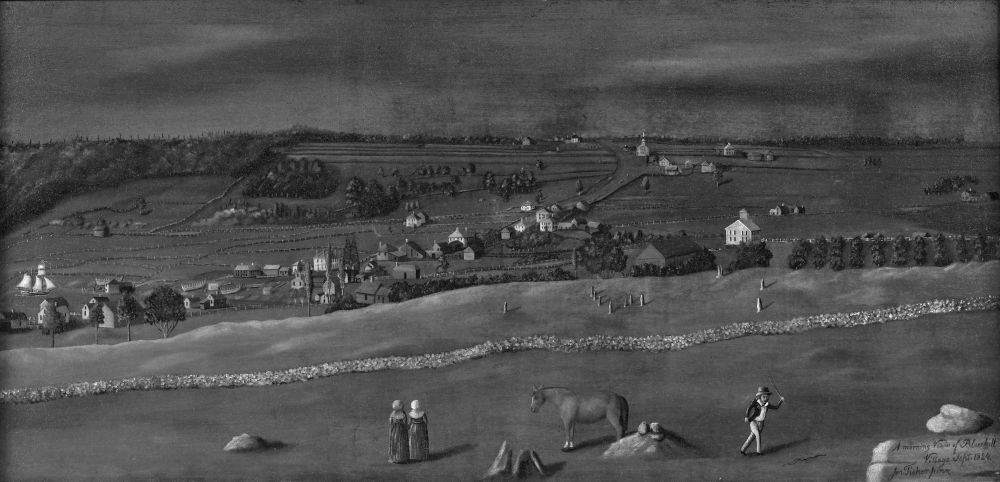
Fig. 1. Jonathan Fisher, A Morning View of Bluehill Village, September 1824, oil on canvas, 25⅛˝ x 52¼˝, 1824–25. Farnsworth Art Museum, Rockland, Me. Museum purchase, 1965.1465.134.
The town of Blue Hill was one community on the eastern frontier that was built up in the Early National period along the lines of nucleated villages in Massachusetts, and it is depicted in Jonathan Fisher’s large painting entitled “A Morning View of Bluehill Village, September 1824” (fig. 1). Fisher (1768–1847) was originally from Dedham, Massachusetts, and was the son of a Revolutionary War widow who had funded his Harvard education largely through weaving and with the assistance of fairly wealthy relatives. Fisher’s education at Harvard was fortuitous since the college was in the late eighteenth century the primary center for the study of perspective.5 a subject in which the budding minister excelled and of which he made use when he was settled in Blue Hill as the town’s first permanent Congregational minister in 1796.6 Early in his tenure at Blue Hill, Fisher produced elaborate drawings for his own house and other architectural projects and began to establish himself as a professional designer. His representational skills enabled him to position himself as a cultural and religious authority in the new town, where white settlers had only arrived in the mid-1760s. In 1814, Fisher added a massive two-story block to his earlier story-and-a-half house (fig. 2), again with the aid of elaborate drawings, and even a model (now lost). Although the new house took years to finish on the interior, on the exterior it proclaimed its designer/builder’s conversancy with the classical tradition through the detailing around the front door and with the wide frieze below the roof.7
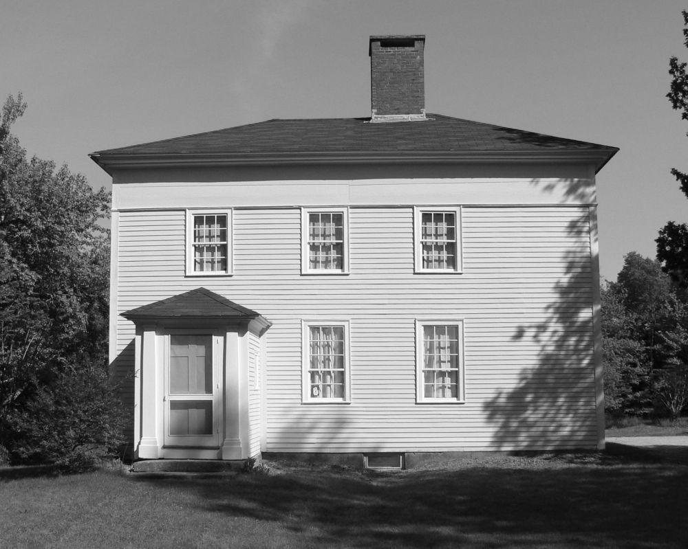
Fig. 2. Jonathan Fisher House, Blue Hill, Maine, showing 1814 addition. Tad Goodale photo.
A decade after its completion, Fisher would depict his enlarged house in one of the very few surviving landscape paintings in oil on canvas from Maine dating to before 1830. On September 15, 1824 Jonathan Fisher recorded in his diary that he had that day carried his camera obscura to a hill on the outskirts of Blue Hill, his home on Maine’s Penobscot Bay, and “sketched the outlines of a view of the village.” He spent the next evening enlarging the design, working from the original drawing, and in the following days stretched and primed the canvas. Meanwhile, getting down the view of the village in a drawing continued to occupy Fisher: in mid-October he was making a stiff paperboard surface “to lay paper on when sketching a landscape” and working and re-working the drawing itself.8 At the very end of October (the 28th) he “went over the pencil marks with the pen.” Transferring the image to canvas, however, had to wait until the following spring when on the nineteenth of May, 1825, Fisher announced to his diary: “Finished my view of Bluehill village.”9
The result of this project, which stretched over some eight months, was Fisher’s best-known work.10 “A Morning View of Bluehill Village” is an image of the many transformations that had occurred in the town, and indeed throughout New England, in the years since 1796. The picture’s perennial appeal may derive in part from its close correspondence to a romanticized image of the prototypical New England village, developed in the nineteenth century. That prevalent stereotype of neat white houses grouped around a meetinghouse and village green bears little resemblance to actual colonial settlements. Such images do, however, correspond to the nucleated villages that emerged in the Early National period and were celebrated in literature and works of visual art, starting in the 1820s, the very moment that the social order the villages were supposed to make manifest was being challenged by historical change.11 Fisher’s painting serves just this ideological function of representing order and stability—indeed, almost timelessness—in the face of manifest challenges to the institutions and social groups in which he had participated since the 1790s. The artist’s insistent rendering of boundaries—wood fences and stone walls—seems an ill-fated attempt to contain a community that was growing, changing, and increasingly questioning the authority of the Congregational church and its minister. The picture inscribes Fisher’s conception of order onto the space of Blue Hill at the same time that it uses the system of perspective to create order in the representation itself.
During the decades leading up to the completion of Fisher’s Blue Hill picture, the town had been settled and Fisher had played important roles in founding many of its cultural, religious, social, and educational institutions, from the library to the singing school, from the Academy to the Sabbath School association. The same quarter century had also witnessed the larger transformation of Maine from a “District” of Massachusetts to an independent state in 1820. The area’s changed political status reflected its enormous population growth from 1760 when a variety of factors, including the exhaustion of land and timber further south in Massachusetts, had begun to push settlers into the Northern New England “hill country” south of the White Mountains and east of New Hampshire’s Lake Winnepesaukee.12
At the turn of the nineteenth century, the eastern shores of Penobscot Bay, where Blue Hill is located, were at the northern edge of the thinly-settled hill country. The town of Bucksport, at the head of the Penobscot River, was the gateway from the west to a spit of land—the Blue Hill peninsula—that runs some thirty-five miles southeast to Eggemoggin Reach, which separates the mainland from Deer Isle which lies on the other side. Situated on the peninsula, southeast of Bucksport, the town of Blue Hill, like the rest of the Penobscot Bay region, was almost entirely uninhabited by whites until the 1760s. After that time settlers were drawn there and even further “downeast” by the possibility of procuring available land. In addition to the land itself, this eastern frontier also held out the prospect of valuable natural resources, like fish and timber, to be exploited for profit, which constituted another draw for people from further south in New England.13
In the post-revolutionary period up to the moment of statehood in 1820, the District of Maine gained nearly a quarter million inhabitants, many of whom were farmers and others who participated in shipbuilding and maritime trade, both of which prospered in Maine, although after 1800 political and economic instability caused periodic disruptions to industry and commerce. The Embargo Act of 1807, the Non-Intercourse Act of 1809, and the War of 1812 all imposed limitations on American international trade, with varying degrees of severity, and all interrupted Maine shipbuilding and shipping in different ways, creating hardships for many in the recent coastal settlements. Blue Hill was among the Maine towns whose shipbuilding industry was threatened by the national government’s policies regarding international trade and that formally protested against the Embargo, with Jonathan Fisher sitting on the committee that drew up the resolution.14
Fisher, who commented rarely on political events in his diary, recorded salient information regarding the War of 1812 in a commonplace book, in which he copied a line from the Boston Weekly Messenger in 1813: “District of Maine, distressed for want of provisions,” probably because it resonated with his own experience. At about the same time, he noted that “Hunger prevails in some sections of our District. A woman and two children have died of it in Frankfort [a nearby town on the Penobscot River]. Our own bread allowance is but ½ of our usual supply, and, therefore, we eat with particular relish what we have.” Fisher also copied into his commonplace book newspaper articles on both the War of 1812 and on contemporary political events in Europe, particularly the Napoleonic wars. In his journal he made explicit the connection between his two favorite topics: “I believe [the War of 1812] to be unjust on our part and greatly impolitic, a war which, I fear will issue in the subjection of America to Bonaparte, the despot of Europe [. . .]” Later, Fisher exclaimed to his journal in 1815 that he was “In consternation through a report that our vessels are condemned and to be taken by the British to Halifax,”15 underscoring the centrality of maritime trade to the District of Maine. Fisher was undoubtedly troubled by the international conflict that disrupted the flow of settlers to the eastern frontier and the livelihoods of those who were already there, and he remained conservative in his politics. He was among those Maine residents whose opposition to Jefferson’s Embargo and whose horror at the seizure of the nearby town of Castine by the British in 1814 sealed his association with the Federalist party.16
Fisher’s painting of Blue Hill village constitutes a very persuasive argument for the parson’s centrality in the place to which he devoted most of his life, not the least of all because he uses perspective to represent metaphorically his social and religious authority in spatial terms. Taking up a position from which to sketch on the hill opposite his house, Fisher was able to construct a scene that put his own residence at its center. Indeed, in the painting his farm occupies a spot very near to—if not dead on—the vanishing point of the composition. The orthogonal lines of the perspective system Fisher employed all recede to that single vanishing point. The Jonathan Fisher house sits, in the painting, just to the right of the center of the horizon line, at the top of what is now known as Tenney’s Hill, at a higher point than even the spired meeting house. By setting up his camera obscura near Mr. Treworgy’s house, Fisher was able to compose his view of Blue Hill so that it would emphasize his own crucial position in the place, if not his panoptic view of the village and its inhabitants. The fact that Jonathan Fisher painted his town at the moment at which he did, at the point when it had accumulated the institutions and fine residences that made a place a “village” in the Federal period, suggests his awareness of the process of establishing a settlement. The painting also demonstrates the degree to which its artist considered himself central to that process.
While in the Blue Hill painting Fisher captured the experience of viewing the village, the 1814 addition to his house enhanced the prospect over the settlement at the head of the bay. Fisher’s first house had been oriented in the traditional way, facing south, and thus away from Blue Hill. The addition, however, shifted the orientation of the main façade to the road (at the west). Nevertheless, in the addition Fisher made far more of the view of the village since the new parlor at the front enjoyed an elevated prospect over the town to its north. The rows of apple trees in the orchard to the north of the house seemed to trace the sight lines from the parlor windows over the settlement at the head of Blue Hill Bay. In other words, the view from the north side of town toward his own house, which Fisher captured in the painting, was returned by the gaze of the house’s inhabitants over the village below.
The dynamics of viewing, as captured in Fisher’s painting of the new settlement of Blue Hill, a growing commercial juncture on the edge of the Atlantic, reflected the young Jonathan Fisher’s conception of himself as an important, if not the only, cultural and religious authority in the place. What distinguished Fisher from other settlers of the eastern frontier were precisely his cultural ambitions and the kit of intellectual and artistic tools he brought with him to Blue Hill. In a newly-established place, and at a politically and economically precarious moment, Fisher deployed an array of self-representations to position himself as a member of the local elite. Understanding how those projections of the self succeeded or failed to establish Fisher’s place in the community provides a window onto the larger question of how space was mobilized in contests for authority in early America.
A Morning View of Bluehill Village was the most succinct statement Jonathan Fisher ever provided of his view of the ideal Puritan settlement. In it, he makes order out of a landscape which—even if it wasn’t quite in a state of chaos—was nonetheless a place that was changing in every possible way during the eventful decades in which he was the parson there. In some respects, Fisher was resilient to change, for instance, when he capitalized on growing markets for the home products he sold to advance his family’s economic standing. In other ways, for example with respect to his Federalist politics and with regard to church discipline, he refused to soften his positions and ended up by driving members of his congregation away from the Church and failing to respond to political and religious transformations. Fisher could not, as the picture of Blue Hill illustrates, relinquish his image of the harmonious Puritan village. The new houses, the vessels under construction, the churches springing up in opposition to the Congregational meetinghouse, all of these elements of the growing, changing and prospering village are held in place in Fisher’s picture of Blue Hill thanks to his use of perspective; none of them to any great degree disrupts the fundamental order of the place. The painting is the visual fulfillment of Jonathan Fisher’s wish for how Blue Hill would develop, of how a traditional view of place could accommodate change.
Maine’s elite of the Early National period were well aware of the influence that material things could wield in a bid for authority on the local level. However, Jonathan Fisher was quite rare—with respect to those who deployed imagery for political, social, and religious purposes—in that he made landscape paintings. Other members of the elite had their portraits painted, built high-style houses and laid out elaborate grounds around them as ways of claiming status locally, both in Maine’s more established towns and on the frontier. In the older settlements, for instance in southern and coastal York County, such architectural and landscape statements were incorporated into village improvements of the Early National period. On the frontier, ambitious buildings and grounds produced jarring juxtapositions with the generally modest architecture that had been planted on the newly-cleared land.17
The great frontier houses enjoyed a relationship to the surrounding buildings that recalled the ways that grand eighteenth-century houses had related to their neighbors: “The eighteenth-century mansions,” writes Richard Bushman, “had risen like bright sentinels of culture above the surrounding rough, dark houses of the common people.” By the nineteenth century, Bushman suggests, the general level of refinement in houses of all ranks had increased. Mansions were thus, in many places, not the anomalies that great eighteenth-century houses had been, but simply larger versions of what people at different economic levels all aspired to, and to some degree attained.18 Bushman’s generalization may apply to the early nineteenth-century mansions of Maine’s more established port towns, Portland among them, but on the eastern frontier the eighteenth-century model seems to have persisted. There, in the absence of well-established settlements, the grand houses of the Early National period stood for exceptional wealth and cultural ambition well beyond the means of most settlers. Moreover, they show how the spaces of the frontier settlements became battlegrounds in contests over economic resources, as well as cultural, social, and political authority.
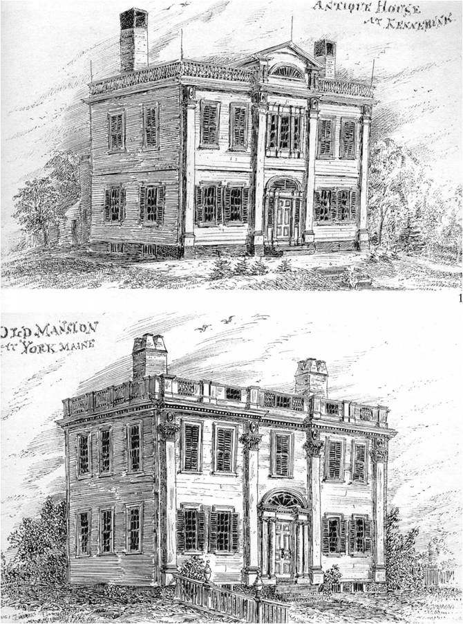
Fig. 3. Coventry Hall, York, Maine (1794–6) and the Judge Jonas Clark House, Kennebunk, Maine (addition, 1800–03), from William E. Barry, Pen Sketches of Old Houses (1874).
Of the many examples of ambitious village seats that might be understood as concretizations of status claims made in the long-standing communities of southern Maine during the Early National period, several houses designed and built by the housewright Thomas Eaton (active 1794–1831) in York County stand out. The first of these (in this case, only attributed to Eaton) is Coventry Hall (1794–6, fig. 3), the residence of Judge David Sewall and “York Village’s only elaborate, completely new mansion of the Federal era.”19 Architectural historian Richard M. Candee has compared Coventry Hall to the elaborate urban houses designed around the same time by Boston architect Charles Bulfinch (1763–1844) and Connecticut architect and author Asher Benjamin (1773–1845). In York, Eaton followed the lead of these city architects in interpreting for the New England context the Roman neoclassicism developed during the eighteenth century in Great Britain by the Adam brothers and other designers. Thus Coventry Hall possesses a five-bay façade with center entrance surmounted by a fanlight, a balustrade at the roof, and ionic pilasters that run from basement to roof cornice and divide the elevation into three parts, all Adamesque elements. These neoclassical features are constructed, however, of the locally-favored building material—wood—rather than the masonry used for ambitious houses by urban architects in Britain and North America.
Even though he was building in a village, Eaton drew more directly from designs for country seats than from townhouse plans. This tendency is seen in the forms of the house itself, but more significantly, in its placement on the landscape. Judge Sewall signaled his social position through the sheer scale of the house, with its stylishness that associated it with the recent residences of other wealthy New Englanders, and through the way his house was sited in relation to the village center. Coventry Hall sat just outside the village—which already in the Early Republic had the reputation of being an old, established place—on the northeast side. Situated on a slight rise, the house addressed the village across a terraced yard, surrounded by a fence with posts surmounted by urns. The orientation of the house was not to the road but instead to the southwest towards the village, which comprised a cluster of houses and public buildings, including the famed eighteenth-century gaol, which it faced more or less directly. A few years after the completion of Coventry Hall, a debtor’s cell would be added to the gaol and a new courthouse built nearby in recognition of the town’s status as the county seat, a role that it played until 1832. A visual connection was thus established between the house and the expanding village, and the position of Coventry Hall on a rise above the town center metaphorically represented the relationship Judge Sewall occupied with respect to the townspeople: he was in the top two percent of taxpayers in York County in 1816, hence somebody of substantial means,20 and he had a socially authoritative and prestigious occupation. The siting of Sewall’s elaborate residence made materially manifest his position of superiority with respect to the community in York Village; in other words, it spatialized his standing in relation to other townspeople who could scarcely have ignored his house, which was an important component of the group of new buildings that added to the significance of the town center.
It is certainly plausible to assume that the house’s formal qualities—its refined classical details, smooth wood façade and more—and its self-conscious siting with respect to the village center would have been understood by others to embody a claim for its owner’s importance and authority. Indeed, the multiple implications of having an elevated view had been understood since the mid-seventeenth century, and the topic of commanding views had been discussed in “country house painting, poetry and landscaping throughout the seventeenth and eighteenth centuries.” The command implied by the term “prospect,” “was as much social and political as spatial.”21 Thus, Judge Sewall’s gaze from his fine residence, across his fenced yard, and over the village would have been understood as a metaphor for his role as a legal overseer of the town and county and for his economic superiority in the community.
Similar to Coventry Hall in design and relationship to its site is the major addition made by another judge, Jonas Clark, to his house in Kennebunk between 1800 and 1803 (fig. 3). Local tradition that credits Eaton with the design is substantiated by formal similarities between the two buildings. The addition, which was like Jonathan Fisher’s 1814 project in that it really constituted the construction of a new house for which the existing one became an ell, resembles Coventry Hall in having a façade divided into three parts by pilasters, a fanlight over the door, and in this case a flat-head Palladian window above the door and a louvred fan in a projection above the center bay at the roof level. Just as does Judge Sewall’s house, Judge Clark’s sits on a rise outside the village, which affords it a prospect across a terraced lawn toward the center of town. And as Fisher’s addition did, so too Clark’s reconfigured the relationship between his house and the village that it faced instead of the road after the expansion. Eaton is known to have substantially remodeled and added a spire to Kennebunk’s meeting house in 1803–4, making it an even more prominent marker at the intersection of the north-south turnpike (now Route One) and Summer Street, which ran east from the village of Kennebunk to Kennebunk Landing (on the Kennebunk River where much shipbuilding took place in the nineteenth century) and then to Kennebunkport on the coast. Judge Clark’s house enjoyed an uninterrupted view toward the church and this major intersection. The siting of the house thus visually emphasized the owner’s prominent social and economic position at the same time that it gave Clark a fine prospect over the village, which was just then being monumentalized in consequence of its prosperity that had come from shipping and shipbuilding.22
Clark, who came to Kennebunk from Portland in the mid-1790s, was considered one of the major investors in shipbuilding during the period. He also ran a store with a partner and became a special justice in the Court of Common Pleas around 1800. Although it is difficult to attribute Clark’s professional success strictly to his house, it is the case that following the construction of the major addition to it, he was made a standing justice of the Court of Common Pleas (in 1808), collector of customs in 1810, and Judge of Probate in 1815.23 While his spatial position with respect to the rest of the community may not have guaranteed him unchallenged authority, it did make it absolutely impossible for others not to literally look up to him as they moved through the principal nodal point in the village.
Both of these judges’ houses stood out from their neighbors by virtue of scale and design sophistication. Despite drawing on the models of country seats, with their long prospects over fenced yards, these houses nonetheless belonged to established villages where there were other large residences and public buildings. Much more ostentatious standouts were built on the Maine frontier in the Early National period, including the house of Gen. Henry Knox (1750–1806) in Thomaston, known as Montpelier (fig. 4). Along with Coventry Hall, Candee considers Montpelier “one of the first high-style neoclassical seats in the District of Maine.”24 Like the judges’ houses in York and Kennebunk, Montpelier bears many similarities to elaborate residences of the period, and especially to those designed by Bulfinch, to whom the design of Montpelier has been attributed. Like others of Bulfinch’s houses, especially those constructed in semi-rural locations, Montpelier (built in 1794) featured an elliptical salon that provided access to elaborately laid-out grounds. As the Reverend Paul Coffin reported on Montpelier in 1796: “The General has a garden fenced ovally. Indeed circles and semi-circles in his fences &c., seem to be all the mode here.”25 These curved forms—appearing in the plans of rooms and gardens, as well as in decorative details in buildings and furnishings—were part of the vocabulary of stylish residences of the Early National period; ultimately, the forms were derived from British and Continental models. For Knox, George Washington’s Secretary of War, who had gained possession of the Waldo Patent—a tract of Maine land more than a half-million acres in size—through his wife Lucy Flucker whose Loyalist parents had controlled three-fifths of it before the Revolution and through a series of surreptitious post-revolutionary land purchases,26 an oval salon overlooking a fenced garden and the St. George River beyond contributed to his ambitious architectural and landscape statement on the frontier. Although it was to be built on a large scale and following a stylish plan, Montpelier—according to the contract Knox made with his Boston housewrights—was to be “plain without carving or other expensive ornament.”27 Its impressiveness was to have derived from sheer bulk and its visual association with Bulfinch’s grand domestic projects built closer to New England’s urban centers.
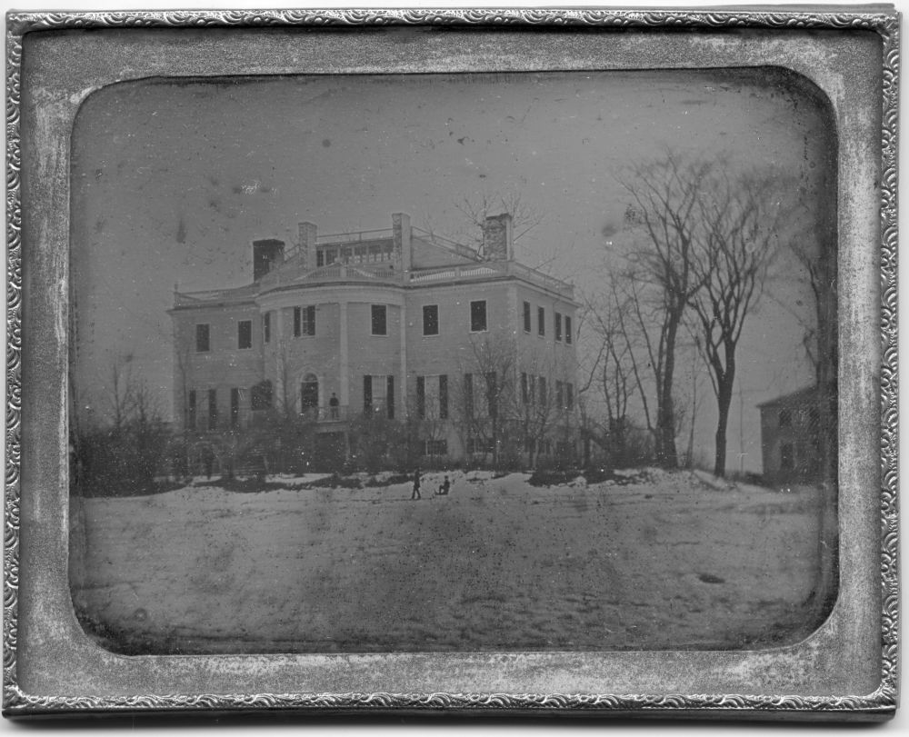
Fig. 4. Montpelier, Daguerreotype, c. 1865. Collections of Montpelier, the General Henry Knox Mansion, Thomaston, Me.
Like Blue Hill, Thomaston saw the construction of its first houses by white settlers in the 1760s. Thirty or so years later, when construction of Montpelier was begun, there were only two other houses there of two stories in height. Nineteenth-century historian Cyrus Eaton described the Thomaston area in 1796 as
. . . still a woody region, interspersed with straggling clearings, dotted here and there with small low, unpainted houses, many of them of logs and some few of hewn timber, distant from each other, along half made or newly laid out highways scarcely fit for wheel vehicles of any kind.28
In such a setting, the fashionable Montpelier stood out at the same time that it stood for Knox’s high expectations for his place in the community. Moreover, the house (although only used for part of the year, in the warmer months) was the place in which the Knox family staged their refinement and their cultural distance from the community around them. What the Reverend Coffin remembered from his visit to Montpelier in mid-August 1796 (besides the chilliness of the house) was his dinner with Lucy Flucker Knox, her daughters, and Mrs. William Bingham (the wife of Knox’s wealthy partner, William Bingham of Philadelphia) and her sister and daughter. “We had a merry dinner,” recalled Coffin, “the little Misses talking French in a gay mood. Mrs. Bingham was sensible, and had been in France, could talk of European politicks, and give the history of the family of the late King of France & c.”29 Following the general’s death in 1806, the family’s financial fortunes declined, but Lucy Flucker Knox maintained her sense of their genteel status. Her local reputation for aloofness outlived her by decades: even into the early twentieth century it could still be recalled that “Widow Knox, whose tastes in society were so exalted that she had never entered the house of anyone in Thomaston, always [sent] her coachman on any errand while she remained in her carriage.”30
As Alan Taylor has argued, Montpelier perfectly expressed the absurd grandiosity that characterized Knox’s economic exploitation of his Maine lands. He started numerous undercapitalized enterprises along the St. George River in Thomaston that produced everything from barrels to bricks, and operated mills as well as West India vessels, among many other businesses. Teetering on the brink of bankruptcy did not stop—and may even have encouraged—Henry and Lucy to “obsessively [squander] their resources to demonstrate their wealth, power, taste, and enlightened benevolence to the watching world.” With its paired crescents of outbuildings, the landscape around Montpelier was a material expression of Knox’s intention to put himself at the center of the region’s economy.31 In that the entire complex of buildings was subjected to an over-arching neoclassical aesthetic—the curved fencing, for example, echoing the plan of the oval salon—Montpelier emulated the country residence of prominent families further south in New England. The house was conceived of as an instrument for convincing the local population of the Knox family’s superiority and hence of silencing any objections to Gen. Knox’s autocratic control over the land and the economy.
Other, albeit more modest examples of houses that visually dominated the spaces around them as a means of demonstrating gentility, in addition to social, cultural, and economic authority, sprang up even further east on the frontier than Thomaston and they drew on both rural and urban models of how an ambitious house should occupy its setting in order to suggest its owner’s prominence. An outstanding example is the house of Judge Thomas Ruggles in Columbia Falls (fig. 5) in Washington County northeast of Blue Hill, which was modeled on an elaborate urban house, despite having been built in a relatively new settlement. Like Jonathan Fisher, Ruggles came to the District of Maine from further south in Massachusetts in 1796. Settling in what had been Plantation 13 before 1796 and Columbia afterwards, Ruggles amassed a fortune by selling the timber from the vast tracts of land he purchased in Washington County and by exporting it in his own ships. At the time of Ruggles’s arrival, Columbia possessed several substantial houses, a two-story inn, and saw and grist mills that created economic opportunity for the community of a little more than two hundred, clustered around the Pleasant River. The area was also home to a vigorous shipbuilding industry, and Ruggles acquired part interest in nearly a dozen ships constructed locally between 1802 and 1815. Ruggles’s business interests undoubtedly colored his political views, which were Federalist, and led him, like Fisher, to oppose officially the Embargo Act.32
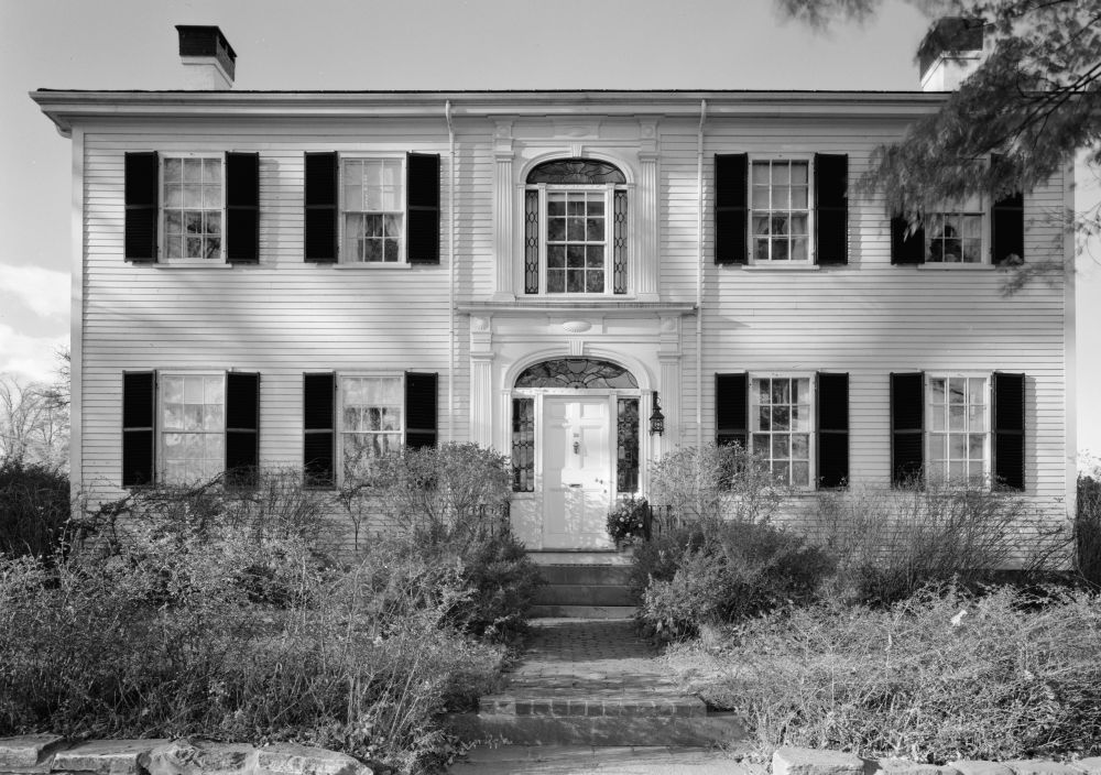
Fig. 5. Ruggles House, Columbia Falls, Maine (1818), Historic American Buildings Survey, Library of Congress, Washington, D.C. Cervin Robinson, Photographer October 1960.
In recognition of his growing wealth, Ruggles acquired several important government posts, including chief justice of the Court of Sessions in Washington County. Like Fisher, Ruggles was conservative with respect to the timing of his investment in an ostentatious house. Both Fisher and Ruggles waited out the economic vicissitudes that accompanied the Embargo and the War of 1812 before constructing large residences. While Fisher chose to make a major addition to his existing house, Ruggles built an entirely new one with the assistance of Massachusetts housewright Aaron Sherman in 1818. The Ruggles house shares much with other large Maine residences of the Federal period. It has a five-bay façade, center entrance, hip roof, fanlight over the front door, and Palladian window in the second story. For Washington County, however, the Ruggles house was extraordinary, especially its elaborate exterior window details and its freestanding staircase in the center hall.33 Like the houses of southern Maine judges, Ruggles’s stood out from the buildings around it by virtue of its unique design, in which Ruth Clapp Ruggles, Thomas’s wife, may have had a hand. Corresponding in some of their details to widely-known builders’ guides by Asher Benjamin, and in certain concepts to the elaborate Boston-area residences designed by Bulfinch, the judges’ houses emphasized their local standing by architectural means. Like Sewall and Clark, Ruggles positioned his house to provide an elevated view of his community. Where most of the standing houses were then clustered on the east side of the Pleasant River, Ruggles built on the west side, on an elevated site oriented to the south. As architectural historian Roger Reed suggests, “[T]the visual prominence of the house would have been especially evident to anyone arriving by water.”34 The Ruggles house also had an entrance portico, which no other in town had, as well as an exceptionally spacious stairhall. Its kitchen was located in the basement of an ell to the north side, an arrangement more common to urban residences of the period. The Ruggles family’s decisions about the site of the house and its design reflected an overarching concern with how the building would be perceived. A visitor who came by water, which many likely did, who saw the house from a distance, would have understood from the presence of the porch that being received by the Ruggleses was a matter of some formality, and finally, if he or she were admitted, the first impression of the hall and stair would have been incredibly impressive.
As an economic enterprise, capitalizing on Maine’s natural resources—especially her vast reserves of timber—as Ruggles did, was a controversial one. Alan Taylor has shown that the land claims of Maine’s great proprietors in the Early National period were frequently disputed by poor settlers who had come to the District specifically to avail themselves of the property that was in short supply in more settled parts of Massachusetts. Social and economic conflict erupted over competing land claims and was expressed politically by the struggle between Federalists and Democratic-Republicans, and religiously between Congregationalists and members of Protestant sects.35 In such an environment, making an authoritative architectural statement such as the one embodied in the Ruggles house would have been strategic. It would have made material Ruggles’s bid to control and profit from the timber trade, and it would have shown his cultural ambition in three dimensions. At the same time, this astonishingly elaborate house would have turned the village into a space where the disparities between rich and poor, powerful and powerless were articulated by the elements of the built environment itself.
Maine proprietor William Bingham, in addition to parts of Knox’s holdings and others previously owned by Henry Duer of New York, purchased more than two million “unsurveyed, unexplored, and uninhabited” acres of land in two tracts in 1793.36 One, the Kennebec Purchase, comprised much of present-day Somerset County. The other, the Penobscot Purchase, was located in Hancock and Washington Counties, and included the present seacoast towns of Gouldsboro, Trenton, Ellsworth, and Mt. Desert Island. Bingham’s claims were disputed by the previous settlers of the land and he therefore appointed (in 1795) an agent, General David Cobb of Taunton, Massachusetts (a former aide to George Washington), to defend his interests on-site. Cobb traveled back to Philadelphia in late 1795 to meet Alexander Baring (later Lord Ashburton), the son of Sir Francis Baring, who was part of a group of British and European investors who in 1796 would purchase a substantial interest in Bingham’s Maine lands. Bingham’s death in 1804, the Embargo, the War of 1812, and ongoing conflict with timber “thieves” made it impossible for Cobb to bring about the agricultural development of downeast Maine that he had imagined and he returned to Massachusetts in 1822.37
The English-born Col. John Black (1781–1856), General Cobb’s clerk and Sir Francis Baring’s agent, arrived in Gouldsboro in 1799 to take over. Several years later he married Cobb’s daughter Mary and the couple moved to Ellsworth in 1810. Despite his English origins, Black fought in the War of 1812 on the American sid,38 and rose to the rank of general agent of the Bingham estate’s Maine properties. Black’s method diverged from Cobb’s approach to the management of the Maine lands in that he successfully developed their timber resources. Black received a commission on the timber that settlers delivered to the landowners as payment for their tracts, logs that were then “saw’d or hew’d for the European market” and loaded onto the proprietors’ ships for export.39 Black’s success, but also the perceived need to articulate his position through a carefully-sited house, was expressed in Woodlawn, built between 1824 and 1828 (fig. 6). Like the Ruggles house, Woodlawn dwarfed most everything around it, and like all three judges’ houses, stood slightly beyond its village to enjoy a commanding view of the settlement. Woodlawn was originally located on a property of about 300 acres, and the house perched nearly at the crest of a hill that slopes upward from the Union River.40 From there it had a view over the river as well as the buildings of Ellsworth. The townspeople would also have had a good view of the house; it would have been an always visible reminder of Black’s presence there as the agent of the major landholders in the area.
Fig. 6. East Front and Office Wing, “Woodlawn,” Ellsworth, Maine (1824–28), Historic American Buildings Survey, Library of Congress, Allen L. Hubbard, Photographer April 30, 1936.
The distinctive design of Woodlawn enhanced the experiences of both overlooking the river and town from the house, and of seeing the building from the road below or from a further distance away. The plan, uncommon in the area, has been compared to a plate in Asher Benjamin’s The American Builder’s Companion, the first edition of which was published in 1806 and in subsequent editions in 1811 and 1827. Adopting almost verbatim Benjamin’s “Plan and Elevation for a House which is intended for a country situation,” the builder of Woodlawn placed four openings on the east front of the main block of the house and shifted the principal entrance from its customary spot at the center of the façade to the south wing. This wing, matched by another on the north side of the main block, contained an entrance hall and office, while the main block of the house had double parlors running along the east with a stairhall and other secondary spaces at the back. Breaking from Benjamin’s plan, the designer added a porch running the length of the east façade of the main block, with details that nevertheless corresponded to Benjamin’s published drawing of the Ionic order.41 The four front windows, again in contrast to Benjamin’s design, extended all the way to the level of the porch floor, somewhat in the manner of Bulfinch’s contemporary country seats where similar windows enabled movement from the interiors to the porches, terraces, and landscapes beyond. Moreover, they enlarged the prospect over the property, the river, and the great expanse of the frontier to the east.
The prestige of Woodlawn thus derived from a number of sources. It was a visually prominent part of the landscape, it was large, and it was stylistically sophisticated. At the same time that the design referenced a well-circulated pattern book, it also evidenced some creativity on the part of the builder, in the way that he had added the long piazza and carefully fitted its detailing to Benjamin’s neoclassical aesthetic through the use of the Ionic order for the columns and entablature. The local viewers of the house could only have appreciated its difference from the smaller and less carefully detailed buildings nearby in Ellsworth—even the relatively large Federalist residences—which it completely outclassed. Situated on a large property, Woodlawn must also have been understood in relation to the eighteenth-century discourse of the country house in which, as we have already observed, the politics of the prospect were central.
But were houses like Woodlawn significant as anything other than metaphors for what their builders considered to be their positions in the communities around them? Did their domination of the landscape—on the bases of size, stylishness, or siting—have real significance with respect to how local struggles over religion, culture, economics, and politics were resolved? The District (and later the State) of Maine in the Early National period was an unstable place and from the perspectives of the white settlers, its eastern frontier was barely civilized. It is impossible to know how the contests there between Congregationalists and Baptists (and other members of Protestant sects), Federalists and Democratic-Republicans, proprietors and squatters, and others would have been resolved in the absence of Montpelier, the Ruggles house, Woodlawn, the Fisher house, and other buildings that constituted architectural propositions about how the somewhat fluid society of settlers should be definitively organized. What can be said, however, is that these houses powerfully embodied a set of claims about where authority should reside, and that they inscribed those claims in space. They were sites for self-fashioning in which members of the elite staged their identities as religiously, socially, culturally, or economically dominant—or some combination of all four.
To compare this handful of ambitious houses is not to minimize the significant differences between the intentions and aspirations of their various builders. As we have seen, constructing an ambitious house in an existing village that was undergoing rebuilding was a different undertaking than building one on the frontier, and called for different architectural and landscape strategies. Both Knox and Black built houses, at least in part, as a means of insuring that settlers would acquiesce to their economic projects which were seen by some (especially the landless and impoverished) as exploitive. Other builders of ambitious houses, notably Jonathan Fisher, were not angling so much for economic preeminence as for cultural or religious authority over their communities. What all of these builders shared, however, was an implicit belief in the effectiveness of landscapes and buildings as both signs of the men’s positions in their communities and as guarantors of their places in local hierarchies.42 These houses were also significant to local struggles from a material point of view, not just as metaphors. Whereas Knox made Montpelier the center of an economic empire that was intended to engage a significant proportion of the local population in his web of patronage, Fisher’s fancy house provided accommodations for boarders as well as the spaces in which they and the parson could study and recite, thus increasing his income from teaching.
However much social and economic relations may have been legible in the landscapes and buildings that the Federalist elite constructed for themselves, the built environment never effectively squelched opposition. Montpelier, for instance, “the largest and most ornate private building north of Philadelphia,” according to Taylor, was not capable of convincing settlers of Knox’s “taste and magnificence,” nor of his benevolence that would have guaranteed deference from social and economic inferiors. Taylor considers Knox one of the “Federalists [who] eloquently preached the importance of a hierarchical and stable society” but who were unable to make others subservient to themselves merely by “parading their personas of genteel superiority.” Ultimately, argues Taylor, Federalists like Knox failed to recognize (in the 1780s and 1790s) “the enduring potential of the American Revolution’s legacy to legitimate upstarts unwilling or unable to achieve or to endure genteel authority.” The self-perception of Federalist leaders as “Fathers of the People” was untenable in a political environment in which “Friends of the People”—social equals—had staked out a position more in keeping with Revolutionary ideology.43
Calvinist theology shared with Federalism an emphasis on order. Thus Jonathan Fisher’s paternalistic view of his place in the community, although acceptable to other members of the elite, gained little traction with the broader group of settlers from less affluent and educated backgrounds. Increasingly, they were drawn to seemingly less elitist and more equalitarian and engaging Protestant sects, as well as to less conservative political positions. If Jonathan Fisher, like other conservative leaders on the eastern frontier, was ultimately ineffective in securing his place in the community through representations, his attempts to spatialize his claims for authority are nevertheless revealing. They demonstrate just how important landscapes and buildings were to the struggles that characterized the eastern frontier of the Early National period. To this extent, the spatial turn in cultural studies and other disciplines provides a crucial justification for the focus on material things that art and architectural history have always maintained. At the same time, however, it demands that we rethink our understanding of space. As Foucault writes, “[W]e do not live in a kind of void, inside of which we could place individuals and things. We do not live inside a void that could be colored with diverse shades of light, we live inside a set of relations that delineates sites which are irreducible to one another [. . .]”44 So it is with the eastern frontier. Relations between its inhabitants of varying class, social, religious, and political positions were played out in spaces that were punctuated with the material manifestations of their self-conceptions. The central struggles that characterized frontier life, or life in the more established towns, were not played out in some airless discursive realm, but instead in the very real spaces of new or newly-monumental villages.