The Colonial Charting of the Massachusetts Coast
THIS essay examines the chief maps and charts of the Massachusetts coast during the colonial period. Primarily, it is a study of original sources and prototypes, the influences exerted on them and by them, and the group relationships that they exhibit. It includes the Maine coast because Massachusetts then regarded it as part of its territory. Maps of the whole New England region are considered, when they are included, only in relation to their coastal delineation. Special charts of Boston and its harbor are omitted, since they have been the subject of previous studies.1 One of the chief desiderata in the historical cartography of North America still remains a comprehensive and thorough examination of the maps of New England (See Appendix A).
Whatever explorations along the New England coast, whether by Vikings, English, Portuguese, Spanish, or Basque fishermen, may have occurred before 1500, significant cartographical records of them have been lost or are inconclusive. It is not until the end of the first quarter of the sixteenth century that the results of identifiable voyages are found on maps.
1. Verrazzano Gómez, and Sixteenth-Century Cartography
Two voyages of exploration along the North American coast formed the chief basis of the sixteenth-century cartography of New England: those of Verrazzano and Gómez. Both expeditions were sent under official and royal sponsorship; the chief objective of both was to find a westward passage to the Orient, with the result that bays, rivers, and coastlines were carefully noted and examined. Both voyages had a profound effect on the European conception of North America and on its cartographical delineation during the rest of the sixteenth century.
The Florentine Giovanni da Verrazzano, sent by Francis I of France, made landfall on the Carolina coast in March 1524 and sailed northward. Verrazzano’s report of his voyage to the King survives in a copy, the Cèllere manuscript now in the Morgan Library in New York.2 Of several surviving cartographical records showing his discoveries, the most detailed for the New England coast is a world chart by Gerolamo da Verrazzano, the navigator’s brother, made in 1529 and now in the Vatican3 (Figure 37, detail). Eventually skirting Martha’s Vineyard, Verrazzano was almost wrecked on the shoals southeast of Nantucket and Cape Cod, which he said stretched fifty leagues east from the mainland. He called these treacherous shoals Armelline Sirtes after Cardinal Armellini, a hated papal tax gatherer. The recorded wrecks of hundreds of later vessels bear testimony to their danger if not to the accuracy of his estimate of their extent into the main. Turning north but still bearing cautiously away from the shore, he missed Cape Cod and its bay. Somewhere north of Cape Ann, he reported on the Indians he saw, their habitation, clothing, food, and manners. Near Casco Bay in Maine the Indians were hostile, suspicious: “Full,” he wrote, “of crudity and vices.” Gerolamo da Verrazzano’s chart has twenty-nine names between Cape Cod and Cape Breton, with several rivers and bays, although the delineation of the coast is too generalized to make identification of them certain.4 Giovanni da Verrazzano’s own report of the Maine coast is general but vivid: “skirting the coast in a northeasterly direction, we found the country more beautiful, open and bare of trees, with high mountains in the interior which slope down toward the seashore. In fifty leagues we discovered XXXII islands, (a note: the three largest of which we called ‘Le III Figlie de Navarre’) all near the continent: they were small and pleasant in appearance, but high, and followed the curve of the land; some beautiful ports and channels were formed between them.”5 Further northeast on the chart is “Oranbega,” the first spelling and appearance of Norumbega. Verrazzano turned toward France, missing the Bay of Fundy; he sailed along the Nova Scotia coast hastily, if at all, reaching port at Dieppe on 8 July 1524. The most important effect of Verrazzano’s report and maps was, however, not in the delineation of the rather generalized New England coast but in the representation of a great bay or arm of the Pacific that Verrazzano thought he discovered when he saw Pamlico Sound while coasting along the North Carolina Outer Banks. This geographical misconception inspired a long series of further explorations extending into the early eighteenth century and affected the location of the Roanoke (1585) and Jamestown (1607) settlements. In England especially this interest in finding a westward passage to the South Sea resulted in a number of maps toward the end of the sixteenth century showing Verrazzano’s sea or gulf, such as John Dee’s map of 1582 belonging to Humphrey Gilbert, Michael Lok’s North America (1582) based on Verrazzano’s own map given to Henry VIII, and John White’s 1585 manuscript map of the Southeast.6
Two and a half months after Verrazzano’s return to France, another expedition sailed from Spain that had a far wider influence on early New England cartography. On 25 September 1524, Charles V sent one of his ablest captains, a Portuguese pilot, Estevan Gómez, from Coruña on a mission to discover a short route in the North Atlantic to Cathay and the Moluccas. Eleven months later, on 21 August 1525, he returned to Coruña without having found a westward passage. His report to the King and his charts have been lost, and the chief record of his discoveries is in the maps of others. Whether he sailed directly across on the same latitude from Coruña to northern New England or by the trade winds to Cuba and then north toward Cape Cod is not known; the latter is more probable. Oviedo, Peter Martyr, and Alonso de Santa Cruz, who had access to official records in the Casa de Contratación in Seville, describe the land that Gómez explored but are vague and contradictory in the details of the voyage.7 Professor Vigneras, who has found new documents dealing with the voyage, quotes the careful historian Antonio Galvão, a contemporary of Gómez and a fellow native of Oporto: “He went from Galicia to the island of Cuba and to the point of Florida, sailing by day because he knew not the land and because he wished to visit every bay, harbour, river or inlet, to see if he could reach the other coast. It is reported that he came to 44 degrees to the north; from thence he came back again to Coruña, laden with slaves.”8
Before leaving Spain, Gómez must have heard that Ayllón had received a royal cédula on 12 June 1523 for settlement and possession of the present Carolina region, discovered by an expedition he had sent out in 1521. The royal instructions expressly commanded Ayllón to look for a westward passage to the Spice Islands.9 Ayllón in 1524 was preparing another exploratory voyage under his pilot, Pedro de Quexós. This expedition, delayed until the spring of 1525, examined 250 leagues of the southeast coast at least as far northward as the Chesapeake Bay. If Gómez sailed by the trade winds to the West Indies, he would there have learned details of Ayllón’s discoveries and intended plans. In any case, there is little evidence that Gómez touched the coast more than casually south of Monomoy Point on Cape Cod or that Pedro de Quexos went north of the Chesapeake. The coast between these two remained blank on Spanish maps, with an incorrect outward bulge and with no knowledge shown of the region between them except for one name, Cabo de San Juan (? Cape Henlopen).
The earliest map to show the discoveries of Gómez’s voyage is the Castiglioni world chart of 1525.1 It was made by Diego Ribero, a Portuguese pilot, maker of navigational instruments, and map maker in the service of Spain, who was in Coruña at the time of Gómez’s return. Ribero had recently arrived in Coruña to take up his duties in the Casa de la Especiería, the Spanish office of the spice trade, where he was the official cartographer.2 For the New England coastline, Ribero evidently drew on the reports of Gómez (possibly with charts made by him), the crew, and an Indian “interpreter,” captured by Gómez and baptized Diego, whom Ribero had taken into his own house. The two dominant features of the coastline, the pointed Cape Cod and island-filled Penobscot Bay, both unnamed, are given the form and location that they retained on Spanish charts throughout the rest of the century. Between these two Ribero also entered six place names derived from the Gómez voyage; elsewhere, from Newfoundland to the Cape of Florida, there is a generalized coastline with no place names.3
Several other manuscript charts made by Ribero or by his assistants survive: two world charts at Weimar, dated 1527 and 1529, one in the Vatican dated 1529 and a chart of the western hemisphere at Wolfenbüttel circa 1530. All of them are similar to the Castiglioni planisphere in coastal configuration for the New England region but have additions and variations in the names and add numerous descriptive and identifying legends. On the Ribero-Vatican 1529 world map (Borgia I), one of the finest works of cartographic art produced in the sixteenth century, the “Tiera de Estevā Gómez” legend, differing only slightly from the others, reads: “The land of Esteva[n] Gómez which he discovered by order of his majesty in the year 1525. There are in it many trees like those in Spain and likewise fruits and fish and likewise many animals like those from here. The food of the Indians is maize; they are of great stature” (Figure 38).
On 20 June 1528, Ribero and Alonso de Chaves took up their duties as the examining pilots at the Casa de Contratación in Seville, to whom all returning pilots were to report upon oath their discoveries. This information was recorded on a great world chart, the padron real or (after 1527) the padron general, kept in the hydro-graphic office in Seville. No original chart has survived, but the two Ribero charts of 1529 at Weimar and Rome must be similar to the official chart of that period. In 1533, after the death of Ribero, Chaves constructed a chart based on careful study of the official records available to him; this has not survived, but in 1538 or 1539 he wrote a detailed manuscript, a navigational table or rutter, listing the distances, directions, and latitudes of known points on the coasts of the world.4 (See Appendix B.) Alonso de Santa Cruz, the royal Spanish cosmographer, wrote a work, Islario General, that contains detailed maps of various “islands” about 1541–1545,5 one of which is of the region discovered by Gómez. In 1566, or before his death in 1567, Santa Cruz made a map of the western hemisphere between 10° and 42° N.L. that shows the latest knowledge available in Spain, such as the founding of St. Augustine in Florida in 1565 (Figure 39).6 The delineation and place names on the New England coast show little change or increase of information in that region since the voyage of Gómez.
The latter half of the sixteenth century saw the development of brilliantly decorated maps and atlases, in which the careful geographical information given by cartographers, such as Pierre Desceliers, Guillaume Le Testu, and the Homems, was the basis for elaborate pictorial additions by miniature artists. These illustrations, often decorated with gold leaf for wealthy or royal patrons, frequently showed the animals, flora, and native dwellings characteristic—or imagined—of the region.7
Although the Portuguese navigator and would-be colonizer Joam Alvarez Fagundez had explored the Nova Scotia coast and the Bay of Fundy in 1520, before Gómez’s voyage, the first extant chart to show the Bay of Fundy is by the Portuguese Lopo Homem in 1554. Homem’s great bay, which has a wide opening at the north to the St. Lawrence River, shows by its north-south axis and numerous islands that he identified it also with Gómez’s Penobscot. South of the bay he follows the Gómez-Ribero cartography. A chart made in 1558 by Lopo’s son Diogo Homem is similar to the 1554 but closes the strait to the St. Lawrence (Figure 40); both leave the St. Lawrence open to the ocean on the north, showing a belief in a northwest passage, as does the Ortelius world map of 1564.8
Considerable evidence of fishing and fur trading on the New England coast during the latter half of the sixteenth century exists. Important landmarks and good harbors must have been known to scores of mariners who crossed the Atlantic on private enterprise. But the fundamental features of Gómez cartography remained dominant in European maps, though with many small variations of nomenclature and coastline, throughout the period.
2. Champlain
In the early years of the seventeenth century, however, three explorers representing three European countries produced maps of the New England coast that radically changed and improved the delineation of that area: Samuel de Champlain of France, Captain John Smith of England, and Adraien Block of the Netherlands. Each of these influenced later cartography in different ways. They were all interested in finding locations for permanent settlement and in presenting their findings to colonizers who, in turn, needed and required maps for the area of their interests.
Champlain is easily among the half dozen greatest explorers of the North American continent; navigator, surveyor, artist, geographer, map maker, and born leader of men, he explored and charted the New England coast for three years. He accompanied the Sieur de Monts, who in 1603 had received a colonizing grant from Henry IV of France for the region between the fortieth and forty-sixth latitude, roughly from Philadelphia to Montreal. They reached Nova Scotia on 8 May 1604.
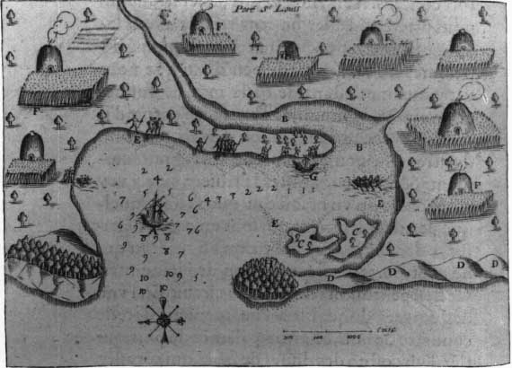
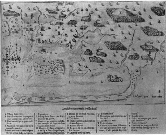
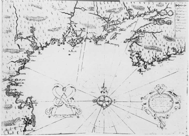
Coasting southwestward along the shore, they eventually explored and crossed the Bay of Fundy and reached the St. Croix River in Passamaquoddy Bay. There they decided to fortify and settle on an island which they called St. Croix because it resembled the Holy Cross. This was the first authorized attempt by Europeans to colonize and fortify New England. Champlain supervised its planning and drew plans both of the settlement and of the island, published in 1613. The location was unsuitable, and the ensuing winter was a bitter and almost disastrous one. The next spring they moved to Port Royal (present Annapolis Royal, Nova Scotia). During the next three years, until 1607, Champlain explored the Bay of Fundy to its head, and made three principal exploratory trips along the New England coast in which he sounded and charted harbors. Champlain’s detailed charts of “Isle de Sainte Croix” (Dochet Island), “habitation de l ile stte Croix” (the fort), “quinibequy” (Kennebec River), “Chouacoit” (Saco Bay), “le Beau port” (Gloucester), “Port St Louis” (Plymouth; Figure 41), “Mallebarre” (Nauset Harbor, Cape Cod), “port fortuné” (Stage Harbor, Cape Cod; Figure 42),9 first engraved for Les Voyages (1613) are not only the first charts with soundings of the North American coast but are the only extant charts of several of the harbors and the surrounding areas made before the end of the colonial period. As Professor Morison wrote in his biography of Champlain, “He had mastered the difficult art of drawing correct outlines of an island-studded bay from an anchorage, and he carefully sounded the approaches. Any yachtsman today, lacking modern charts, would be happy to enter port with one of Champlain’s in hand.”1 Modern charts, as Professor Ganong notes in his edition of Les Voyages, indicate that considerable silting has occurred since then in some of the harbors.2
Champlain explored the southern coast of Cape Cod only a few miles beyond Chatham (Stage Harbor) to a river he called “Rivière de Champlain,” near Wood’s Hole. His best and most detailed map of the New England coast and Nova Scotia is his own original manuscript, drawn on vellum in 1607, now in the Library of Congress3 (Figure 43). He published several other maps: “Carte geographiqve de la Nouvelle Franse,” larger in area and smaller in scale, with inset pictures of Indians and flowers and with (incorrect) longitudes and latitudes in Les Voyages (1613); an untitled map, “faict par le Sr de Champlain. 1616,” known only in one copy in the John Carter Brown Library, with some additions to the 1613 but without the insets; and his last and greatest cartographical production, “Carte de la Nouvelle France,” the prototype of maps of Canada for over a century, in Voyages (1632). These later maps included his discoveries north and west of the St. Lawrence River; “Acadie” and “Norumbega” were no longer important in his colonizing plans.
It is strange that Champlain’s delineation of Cape Cod is so poor, for he explored carefully both its harbor and the outer coast. The curve at the tip of the cape is entirely lacking in all his maps, although he states specifically that “Cap Blanc (Cape Cod) is a point of sand which bends toward the south some six leagues.” A strange geographical misconception found on his printed maps is his placing Lake Champlain, which he discovered in 1609, near the Atlantic coast almost north of Cape Cod; on some later maps this was also confused with Lake Ontario (his Lac des irocois or Lac St. Louis), and a large Meer der Irocoisen for Lake Champlain east of the Connecticut River became a characteristic feature of Dutch maps of New England during the rest of the century, as on the Jansson-Visscher series of maps and on their numerous derivatives.4 Perhaps Champlain may have placed his Lac de Champlain near the Atlantic coast because he remembered accounts he could have heard from Indians in 1604–1607 of a large lake west of the coast (? Lake Winnepesaukee, New Hampshire). But the fundamental reason is that he did not know the correct longitude either of the coast or of Lake Champlain.
Although many names along the coast that Champlain gave are still in use, from Mt. Desert to Mallebarre, and his maps continued to be reproduced in France, the failure of continued French settlement there caused them to be superseded for the coast south of Nova Scotia by the maps of other explorers.
3. Captain John Smith and Early English Maps
Even before the Sieur de Monts and Champlain arrived in 1604, the English were active along the New England coast. The so-called Virginia Company chart, drawn about 1610 and now in the New York Public Library, shows the New England coast in considerable detail, with Cape Cod (“C. Kod”) curved at the tip, prominently featuring the name given to it in 1602 by Bartholomew Gosnold and Bartholomew Gilbert; and “Witstan bay” (Whitson’s Bay), the name given a harbor (Provincetown) in Cape Cod Bay by Pring in 1603.5 Stokes suggests that Hudson had this kind of information before his 1609 trip in which he sailed down the coast before entering Hudson River. After a recent examination, however, Professor D. B. Quinn points out that the map’s details of the Hudson River evidently derive from Hudson’s discovery, that the style bears strong similarities to the work of the Thames School of map makers, and that it has no known connection with the Virginia Company.
A much more expertly designed and detailed map of the period skillfully incorporates information from various voyages and sources. Called the Velasco map because the Spanish ambassador to England sent it to the King of Spain on 22 March 1611, with the note that it was made by an English surveyor sent to America by King James, it includes both the French discoveries along the coast in 1604–1607 and Hudson’s discoveries of 1609.6 A direct influence of Gosnold’s 1602 voyage is a small lake with an island in its center, clearly drawn and colored, which is shown on “Elizabeths He” (? Cuttyhunk Island), so named by Gosnold. Brereton in his Relation (London, 1602) describes the place: “On the Northwest side of this Island, neere to the sea side, is a standing Lake of fresh water, almost three English miles in compasse, in the middest whereof stands a plot of woodie ground an acre or not above. This Lake is full of small Tortoises.” The map may have used documents taken from Hudson by the English government in 1610, as well as the materials for a “perfect Geographicall Map of the country” that Waymouth, a surveyor and engineer, had gathered on the voyage that he commanded in 1605.7 Another English plan of this period we owe to the espionage enterprise of Velasco and its preservation in the Archives of Simancas: “the Draught of St. Georges fort,” the defense of the Sagadahoc colony on Sabino at the mouth of the Kennebec River in 1607, the last English colonizing venture before the arrival of the Pilgrims thirteen years later.8
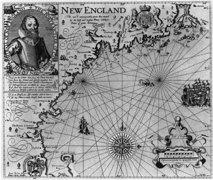
The most famous English map of this period is that of Captain John Smith, who explored the coast for a few weeks in 1614; published in 1616, it was used by the Pilgrims in 1620 (Figure 44). The map was published in Smith’s charming colonizing promotion tract, The Description of New England (1616) and was frequently reprinted, with minor changes in the plate, in his Generall Historie (1624). His map is the most detailed and accurate for the coast between Cape Cod Bay and Penobscot yet to appear; although inferior as a cartographical achievement to his map of Virginia, it is a remarkable accomplishment under severe limitations of time and other activities. “Whilest the sailers fished,” he set out “with eight or nine others of them.…Ranging the coast in a small boat; we got for trifles near 1100 Bever skinnes, 100 martin [skins], and neer as many others.…I have drawn a Map from Point to Point, lie to He, and Harbour to Harbour, with the Soundings, sands, Rocks, and Land-works…I had not the power to search as I would.”9
Before Smith made his voyage to the region to which he gave the name New England, he had read the relations of Gosnold, Waymouth, and others; he refers contemptuously to “many that have beene…in New England many times, that doe know little more then the place they doe inhabit, or the Port where they fished,” but that claim to know all New England as if it were a parish or an island. “I have had six or seven severall plots of those northern ports, so vnlike each to other, and most so differing from any true proportion or resemblance of the Countrey as they did mee no more good then so much waste paper, though they cost me more.”1
Smith’s own draft of the map of New England had Indian names already known to the English such as Pennobscot, Pemmaquid, Sagadahock, Kinebeck, Massachusetts River, Accomack. But for reasons of policy and patronage, he asked fifteen-year-old Prince Charles to “change their Barbarous names for such English” as he would please.2 The young prince chose names entirely derived from those of the royal family and peerage, and from English and Scotch geographical landmarks; Smith took care to list in his Description in parallel columns the names on the original chart with those given by Charles.3 Most of them, like Stuards Bay (Cape Cod Bay), Cape lames (Cape Cod), and Leeth (Sagadahock), disappeared after colonization. Plimouth, the River Charles, and Cape Anna, however, survived.
In spite of its frequent reprinting in England, Smith’s map of New England did not have much influence on continental map makers of the time, who usually followed the Dutch maps. Levinus Hulsius engraved a new plate of the map to accompany his translation of The Description in his Shiffart…XIV (Frankfort, 1617, and later editions). Joannes de Laet’s “Nova Anglia, Nowm Belgivm et Virginia” (1630), Sir Robert Dudley’s “Carta Nuoua Belgica…nuoua Anglia” (1646), and Nicholas Sanson’s “Le Canada” (1656) show sparing use of it.4 Elsewhere, its cartographical effect seems small, valuable as it must have been to the early settlers and mariners of New England.
Another map that was published shortly after the founding of the Massachusetts Bay colony is “The South Part of New-England, as it is Planted this yeare, 1634,” which appeared in William Wood’s New England’s Prospect (London, 1634).5 It is the first map of Massachusetts by a British colonist to be printed and shows the coast from “Elizabeths Ile” to “Pascatagua River” and “Acomenticus” (York; cf. Mt. Agamenticus, three hills in the present town of York); as well as rivers and settlements to the interior. Many names, both Indian and English, first appear on it, such as “Marble Harbor” and “Hands of Shoals.” It is crudely and inaccurately drawn; “Elizabeths He” is off “Narregansetts Bay,” “Wests harbor” [Nauset Harbor] is too far north on the Cape, and the peninsula itself is far too wide at its base.
4. Seventeenth-Century Dutch Cartography
For most of the seventeenth century, Dutch maps surpassed those of England and France because the fifty years of enterprise in New Netherlands coincided with the Golden Age of Dutch cartography. Map makers and publishers like Hondius, Blaeu, and Jansson showed an extraordinary combination of enterprise, geographical judgment, and artistic skill in their productions. At their poorest they embellished old and outdated maps which they continued to publish long after new information was available; at their best they incorporated geographical information from varied sources in original works, decorating them with pictorial scenes, cartouches, and swash lettering to fill the areas for which they lacked information.
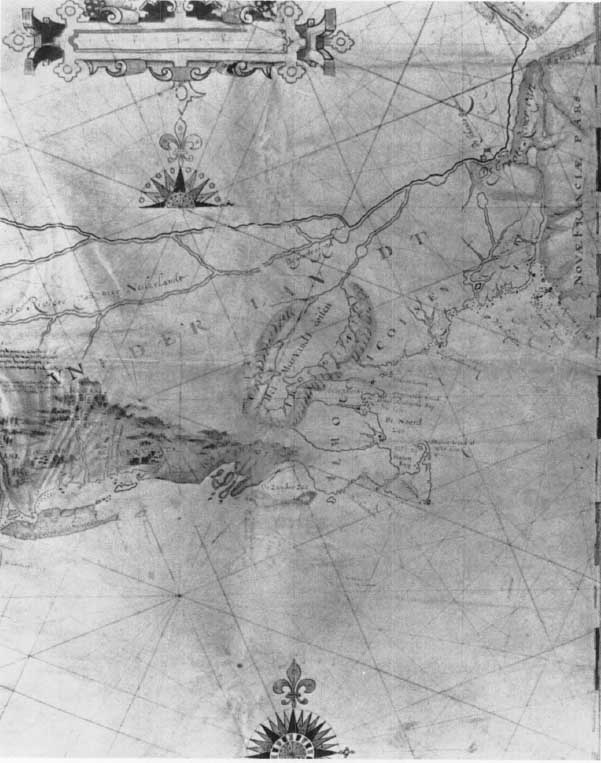
The basic document which they used for the New Netherlands-New England area was a map sent to the States-General in 1614, apparently copied from an original by Adriaen Block, who had explored the coast from New Amsterdam as far east as Buzzards Bay or farther and who incorporated other details from the Chesapeake to Penobscot which were gathered for areas not visited by himself6 (Figure 45). Other Dutch navigators had explored the coast as far north as the Bay of Fundy. Block divides Long Island into several islands, makes the Elizabeth Islands into one dumbbell-shaped island, separates Cape Cod from the mainland by a strait at Buzzards Bay, and exaggerates the size of the lower cape and of Plymouth Bay; but he shows Boston harbor with its numerous islets better than on any previous map. Dutch names replace earlier Spanish, French, and English names along the coast: “De Zuyder Zee” (Buzzards Bay), “Staten hoeck al Wit hoeck” (Cape Cod), “Wyngaerde hoeck” (Cape Ann). Near to the coast and parallel to it is “De Meer Vand Irocoisen,” a greatly enlarged Lake Champlain, apparently derived from Champlain’s map of 1613.
The first published chart to use the information on Block’s map is Willem Janszoon Blaeu’s “Paskaert van Guinea, Brasilien en Westindien,” of about 16177. There are numerous small differences; Cape Cod is not an island. This he followed in 1621 with “West Indische Paskaert,” which not only incorporated more fully Block’s work but also is an entirely new marine chart extending from Newfoundland and Ireland to the Cape of Good Hope and the Horn, and from Asia Minor to Central America. It was the prototype of similar charts of the Atlantic Ocean published by at least eight other European map makers, many from new plates but with only slight changes, until the early years of the eighteenth century.8
In 1630 Joannes de Laet, a Dutch geographer of considerable reputation with special sources of information in the New Netherlands, published a map extending from Nova Scotia to Cape Fear (Cape Lookout), “Nova Anglia Nowm Belgivm et Virginia.”9 Differences from Block show that he used other maps, some no longer extant, for the New England and other coasts. Joannes Jansson copied de Laet closely in a map with the same title which he included in his 1636 and later atlases.1
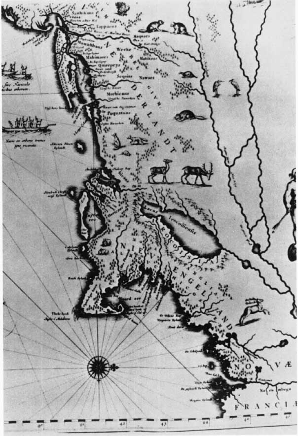
Blaeu published in 1635 or earlier a new and detailed regional map, “Nova Belgica et Anglia Nova,” that followed Block closely in the area shown, the coastal configuration, and the Dutch nomenclature2 (Figure 46). He omits, following de Laet, the strait that made Cape Cod an island and the off-shore shoals, and adds a few English names such as “Niev Engeland,” “New Pleimouth,” “C. Cod,” “Milford haven,” and “point Davis.” The work is a beautiful example of Dutch cartographic art, showing details of two Indian villages with surrounding palisades, three Indian dugout canoes of different sizes, and local fauna such as deer, bears, beavers, foxes, and a turkey.
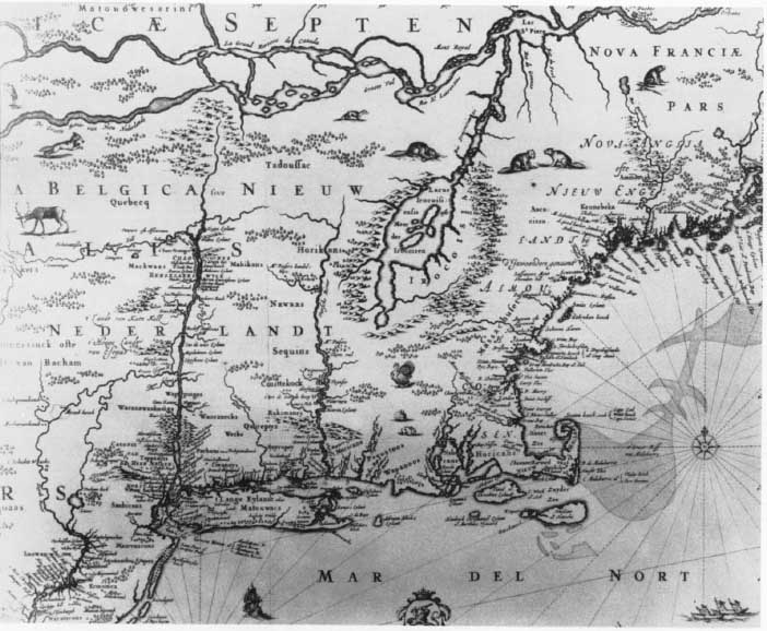
About 1650 or 1651 Jansson, the great rival and occasional imitator of Blaeu, put out a map similar to Blaeu’s 1635 map, “Belgii Novi, Angliae Novae, et Partis Virginiae Novissima Delineatio”3 (Figure 47). Although basically the same, including even the dugouts, Indian settlements, and animals, there are numerous small differences; Long Island is one instead of several islands, a diminutive “Marthaes Vyneard” and a large “Natocke” are added, both absent on Block’s original and Blaeu’s 1635 map, and numerous small changes in coastal configuration and nomenclature are made. Jansson’s map, the best of the region for the time, was reproduced by such imitators as Visscher, Danckers, Allard, Ogilby-Montanus, Seutter and a dozen others, using their own imprint, until well into the eighteenth century, long after more correct maps had appeared. None of them, for example, shows the Boston settlement except Speed in 1776 and Lotter in the eighteenth century, and they locate it incorrectly. This series is usually called the Jansson-Visscher New England; Visscher added a famous view of “Nieuw Amsterdam” to his plate about 1655.
5. Late Seventeenth-Century English Maps
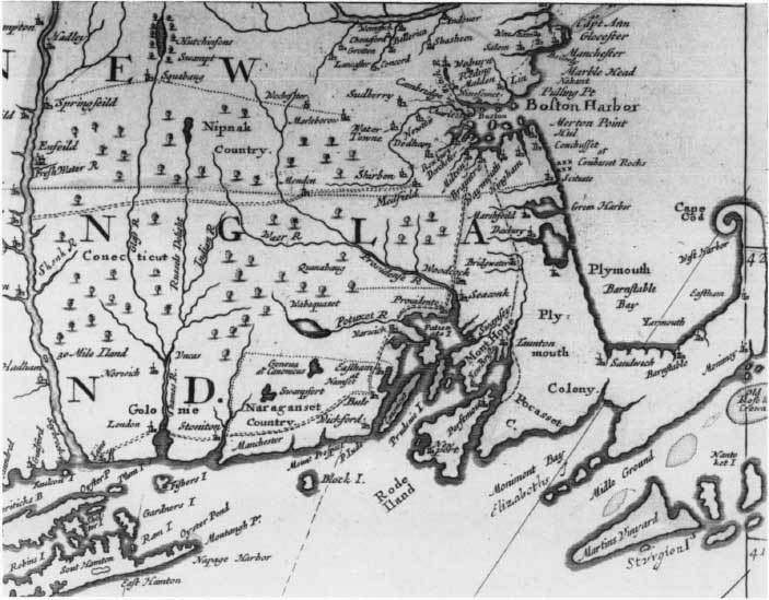
It was not until the last quarter of the seventeenth century that English map makers broke away from their almost complete dependence on Dutch chart makers. For New England the rapid expansion of settlements westward to and along the Connecticut River, the dispute over the boundaries of the Massachusetts Bay Colony, and reports on the location of Indian attacks during King Philip’s War, all contributed to new geographical information incorporated in new maps engraved and published in London. Several general maps that included the British colonies in North America, attempting to use recently available information but differing in details and interpretation, appeared: John Thornton (1673); Robert Morden and William Berry (1673); John Thornton and Robert Greene (1678–1679); Richard Daniel, Robert Morden, and William Berry (circa 1679); John Seller’s charts (1675); and other maps in the following two decades.4
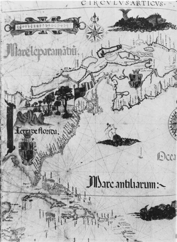
Another group of English maps, also made during this same quarter century after the close of King Philip’s War in 1677, is of special interest because of their marked resemblance to each other in many details of coastal delineation, including the shape of Cape Cod and the off-shore islands; in geographical nomenclature; and in placing Boston correctly on a peninsula in an island-studded bay. The earliest dated map in this group is John Foster’s crude woodcut, “A Map of New-England, Being the first that ever was here cut…” to accompany William Hubbard’s Narrative of the Troubles with the Indians in New England, published in Boston in 1677 (the “White Hills” plate) and in the same year in London (with “Wine Hills” for the White Mountains).5 Seller’s “A Mapp of New England,” apparently made in 1676 although it appears in copies of his Atlas Maritimus (1675);6 the inset, “A Mapp of New England,” in Thornton-Greene’s “A Mapp of Virginia…& New England” [1678–1679]; John Thornton, Robert Morden, and Philip Lea’s “A New Map of New England…” (circa 1685) (Figure 48); Lea’s similar map, with changed imprint, published in 1692; and the well-known “An Exact Mapp of New England and New York” in Cotton Mather’s Magnalia Christi Americana (1702) are almost identical for the Massachusetts-Maine area common to them. Apparently the draftsman or engraver of the Magnalia map used an edition of the Thornton-Morden-Lea map that added a section printed from a new plate affixed above it which is followed exactly in Mather’s map. This four-sheet map, of which the only known copy is in the Bibliothèque Nationale in Paris (Ge. D. 11729) (1), (2), (3), and (4), is dedicated to James II and therefore cannot be later than 1688.7
These engraved maps are paralleled by a number of manuscript maps. The Blathwayt Atlas, a remarkable collection of manuscript and printed maps purchased or specially made for the Plantations Office before or by 1683, has an unsigned, undated manuscript map of New England (no. 8). It was copied in 1678 from a draft brought to England in 1676 by William Stoughton and Peter Bulkeley, two Massachusetts agents sent to present the Colony’s boundary line claims against New Hampshire. Miss Jeannette Black, in her Commentary on the Blathwayt Atlas, shows that the Stoughton-Bulkeley draft was almost certainly a copy of a map drawn by John Reed in 1665 by order of the General Court for the King’s commissioners, appointed by Charles II to examine the Massachusetts boundary disputes.8 The original maps and surveys which Reed used are no longer extant, but one of the persons appointed to prepare the map was Colonel Edward Johnson, who had been a member of the expedition sent to explore the sources of the Merrimac River in 1652. Reed’s copy for the commissioners was lost at sea in August 1665, but the Stoughton-Bulkeley map was made for the two agents in 1676 from a map, presumably the copy of Reed’s 1665 map known to have been kept in Boston General Court archives.9
About 1700 Captain William Hack, a well-known member of what is now known as the Thames School of marine chart makers, drew a “Description of New England in America,” which is now in Plymouth Hall, Plymouth, Mass. With well over 200 geographical names and legends, it is the most detailed of all the maps that, it may be assumed, derive basically from the Reed manuscript of 1665. Neither Hack nor the other map makers were limited to the Reed map for all of the information found in the maps of this group. Hack made several other maps showing New England in some detail but with considerable variations, as Mr. Richard Boulind shows in his study of Hack’s “Description,” the most careful and thorough examination yet made of any New England map.1
Although map makers frequently followed a prototype in drawing a “new” map, variations occur because they found new information, either oral or written, to revise or add to their work. The size and scale of the map, its purpose (such as the addition or deletion of soundings), or other reasons may result in changes. Towns on Foster’s map of 1677 are keyed by numbers to places mentioned in Hubbard’s Narrative, for which it was made, and works like Josselyn’s Voyages (1673) were used by English map makers of this period as well as other earlier relations and maps by Captain John Smith and the Dutch.
6. The English Pilot: The Fourth Book
The leader in initiating an English sea atlas of the whole world was John Seller, Hydrographer to the King, who in 1669 announced his plan to prepare “a Sea Waggoner for the whole World, with Charts and Draughts of particular places…never yet performed by any” Englishman.2 In 1671 appeared the first volume, with charts of the English coast, which he called The English Pilot. Although he had begun by printing charts from “old worn Dutch copper plates” which he had purchased in Holland as scrap, as Pepys caustically remarked,3 he was soon engraving his own charts based on new information, as his Atlas Maritimus (1675) shows.
John Seller, whose financial problems continued to mount, had to involve others in his plans. Among these were William Fisher, bookseller and printer, and John Thornton, an engraver and cartographer, who took over the publication of The English Pilot, and in 1689 issued The Fourth Book, already in preparation ten years earlier. This is the first English book of charts and sailing directions for American waters; it became the Bible of the American mariner and continued to be published for 105 years. Professor Coolie Verner lists thirty-seven editions of The English Pilot: The Fourth Book between 1689 and 1794 and gives a useful table of the first and last appearance of each chart.4 In 1689 “Part of New England…by J. Thornton…and by Will: Fisher,”5 the first of a series of charts for this region, shows “C. Codd” as almost but not quite an island, and with a narrow neck near present Orleans with an open extended “Norset Bay” (Nauset); the size of Buzzards Bay is exaggerated in relation to a much smaller and misshapen Rhode Island, soundings are lacking north of Cape Cod; Plymouth Harbor and the Great Bay of “Pascataway” bear very little resemblance to their actual size or shape. The mariner would be ill-served who trusted to this chart for guidance. It should be noted, however, that the quality of The Fourth Book is not much below that of many other contemporary continental European sea atlases for foreign coasts.
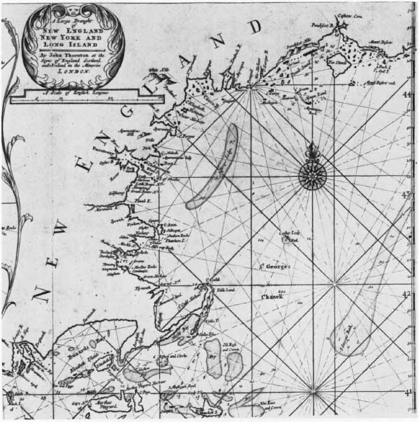
Unlike charts for some other regions along the North American coast in The Fourth Book, which remained unchanged, except for the imprint, for 105 years, the charts of New England were replaced from time to time by new charts. These do not always show noticeable improvement; the replacement for New England in 1706, “A Large Draught of New England New York and Long Island by John Thornton” covers a longer coast but New England remains unchanged (Figure 49). The same enlarged Buzzards Bay and narrow neck of Cape Cod remain, on a smaller scale; but it adds a detailed inset of Boston Harbor. In the 1721 edition a detailed chart of Casco Bay by Southack was added;6 here, as for many other charts, the publishers of The Fourth Book chose or retained a poorer chart when more accurate ones had been made. In the Public Record Office is an anonymous chart of Casco Bay of 1699, the result of careful surveys, showing soundings, more accurately placed islands and hazards, and the site of the proposed location of Portland.7
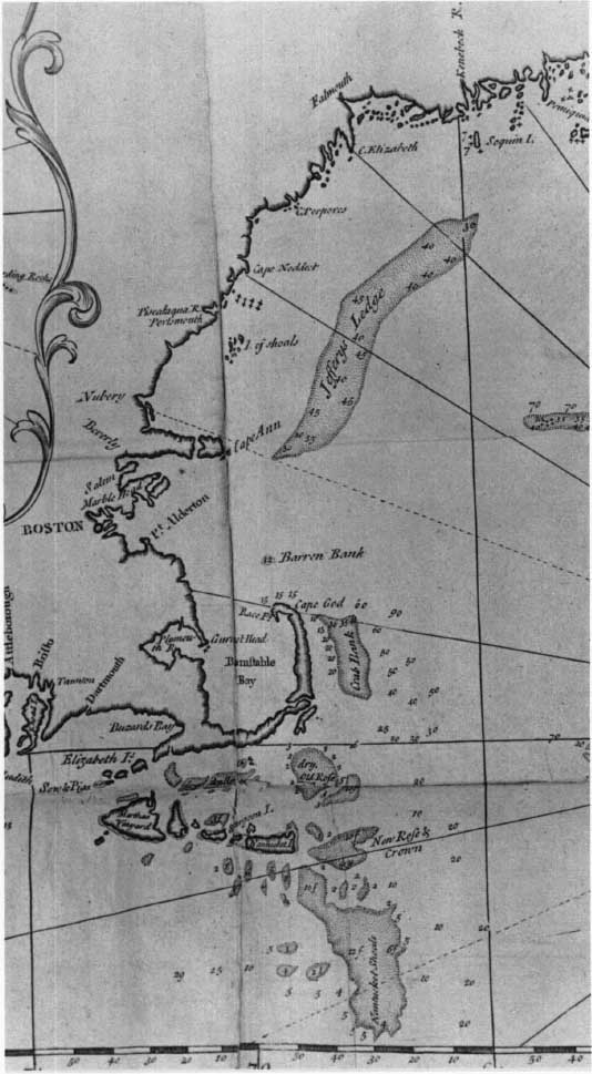
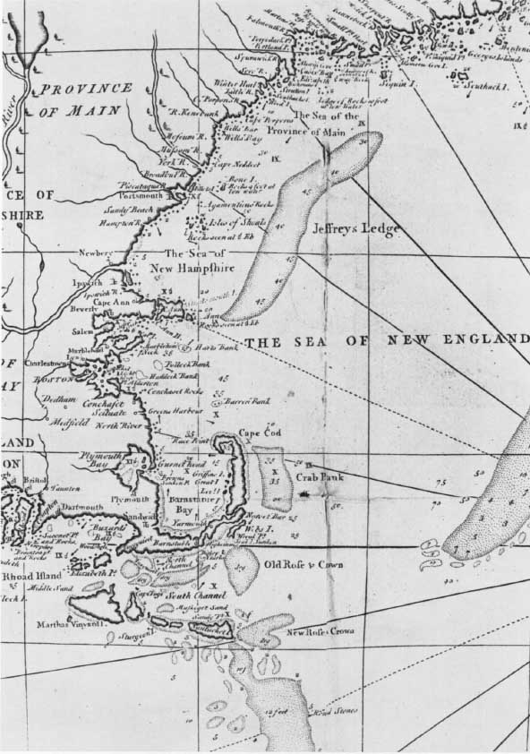
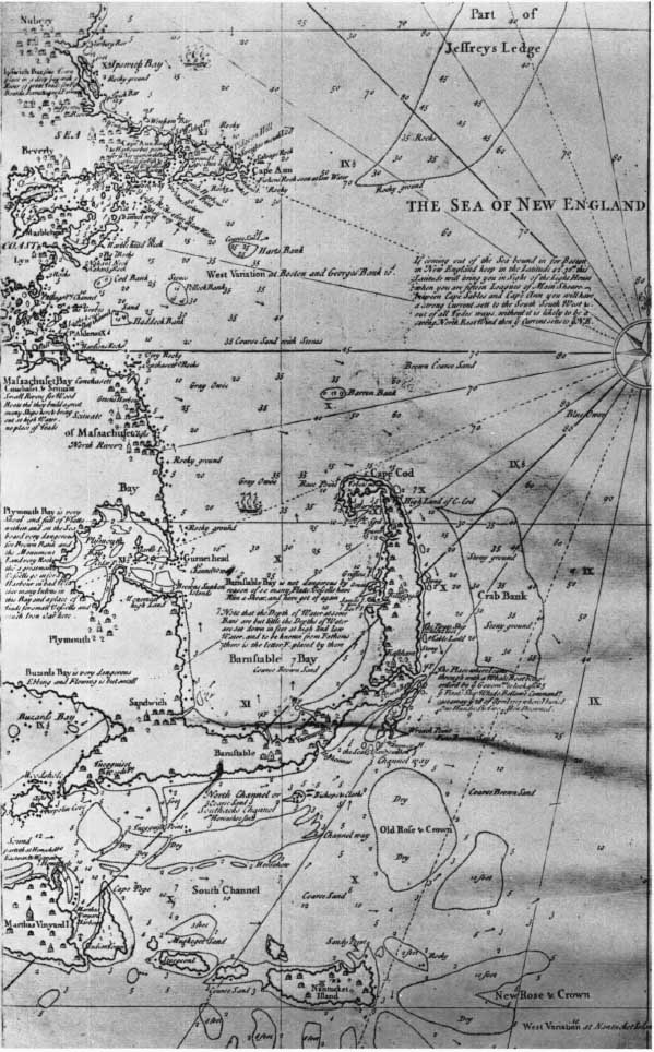
In 1737 the publishers of The English Pilot substituted a new plate, dated 1731, “Correct Map of the Sea Coast of New England,” that replaced the 1706 chart (Figure 50). This chart and Captain Southack’s New England Coasting Pilot8 (Figures 51 and 52), an eight-sheet chart of the coast from Sandy Point, N. Y., to southern Cape Breton Island, published in Boston, probably between 1718 and 1734, are so similar in their delineation of Cape Cod, in the shape of surrounding islands, and in identity of offshore soundings given, that it is reasonable to suggest that The English Pilot used, without acknowledgment, Southack’s printed work or an earlier manuscript version. In both charts Cape Cod becomes an island at the elbow. Southack, however, adds a note on his map that he sailed through this strait: “The Place Where I came through with a Whoale Boat being ordered by the Governṃt to look after the Pirate Ship Whido [Whidah] Bellame Commandṛ cast away the 26 April 1717 where I buried One Hundred and Two men Drowned.” The notorious Captain Samuel Bellamy had been wrecked in a storm on the outer shoals near Wellfleet; Governor Samuel Shute sent Southack to investigate and collect the pirate loot for the Crown. Finding no transportation across the Cape from Provincetown Harbor, Southack with his whaleboat entered Boat Meadow Creek, through Jeremiah’s Gutter (or Jeremy’s Drean, now filled up and paved over as a parking lot for a supermarket on the outskirts of Orleans) into Town Cove and through Nauset Harbor. Southack’s mission was only partially successful; the pirates’ ship had already been completely relooted and stripped by the Cape Codders, and he brought back to Boston only nine of the crew, of whom one, an Indian, escaped, one was acquitted, and seven were hanged. The rest, Captain Bellamy and 144 of his men, had drowned. Captain Southack’s exploit became the route of the oldest hope for a Cape Cod canal; but Jeremiah’s Gutter was probably even then navigable only at high spring tides and remains only a geographical memory recorded on some eighteenth-century charts.9
It was not until 1775 that the publishers of The English Pilot substituted for their “Correct Map of the Sea Coast of New England…1731,” a poor one-sheet version of Southack’s Coasting Pilot, using a plate they acquired that had been made and published about 1744 by John Senex. This chart, already long outdated, continued to appear until The English Pilot’s last edition in 1794.
Southack, whose naval career Mr. Hitchings examines elsewhere in this volume,1 is an example of the enterprise and the deficiencies of the colonial marine surveyor of this period. Although his twenty or more charts of the coast from the St. Lawrence to New York were superior to many contemporary charts published even on the Continent, his methods and hydrographic training were simple. As Braddock Mead [John Green], Jefferys’ geographer, wrote of Southack’s delineation of Nova Scotia: “It does not appear that in making this chart [Southack] employed any instruments excepting the Log and the Compass”; and Dr. Douglass, writing a few years later, said “His large chart, being one continued error…ought to be…destroyed wherever it is found among sea charts.”2 It should be noted, however, that the Coasting Pilot is the most ambitious chart of the New England coast to the time of its publication, and includes numerous legends embodying Southack’s long practical experience and knowledge of its harbors and navigational perils.
Little is known about the methods of the publishers of The English Pilot: Fourth Book; but it seems obvious that their standards of production were low, that the engraving was primitive, and that they had little concern in improving the accuracy of their charts. They refused to produce better charts that were offered them, and bought for inclusion old plates of charts over thirty years old that were second-rate when made.3 How they obtained the charts that they did use, and how much if anything they paid the original contributors, is not known. The Fourth Book was evidently a low-budget operation after its initial 1689 publication, and lack of other competition for most of the eighteenth century discouraged the publishers from the expense of new plates with its consequent lowering of their margin of profit.
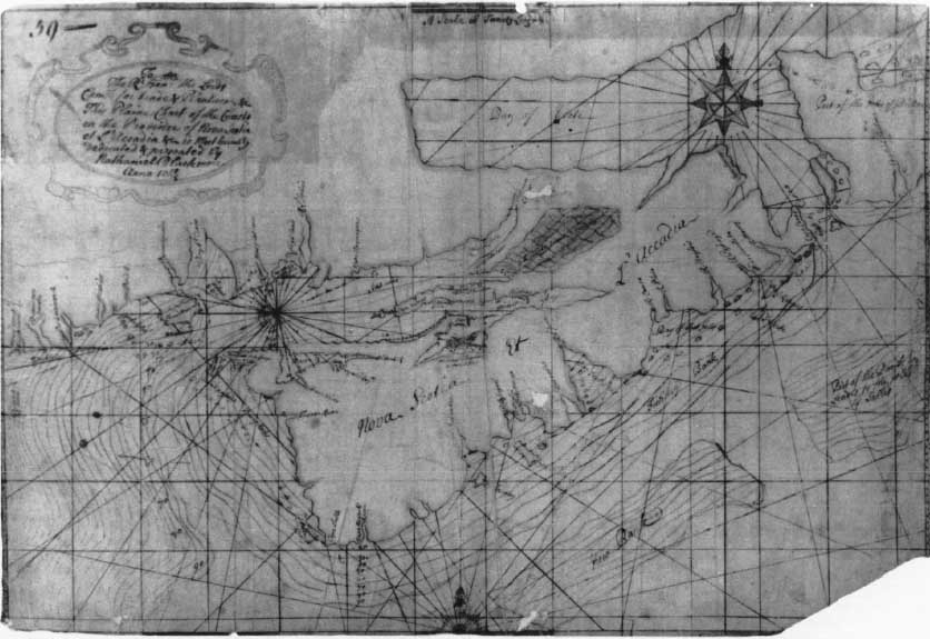
Among the numerous manuscript maps showing the New England coast in the last quarter of the seventeenth century and beginning of the eighteenth is a chart deserving special mention because it may be the earliest to use isobaths or contour depth lines for the open sea. “This Plaine Chart of the Coasts on the Province of Nova Scotia et L’Accadia &…by Nathaniel Blackmore anno 1714/15”4 (Figure 53), which includes part of the coast of Maine, has a series of lines off the coasts with accompanying depth soundings from “20” to “90” that surround the Nova Scotia coast. Similar soundings varying irregularly from “20” to “90” are off the Maine coast; but the contour lines are not consistent. Professor Arthur Robinson of Wisconsin, who has made a special study of the chart, suggests that, if they are isobaths, Blackmore may not have understood or followed completely the principles involved.5 The only previous known use of isobaths was for channels in rivers by Pieter Bruinss in 1584 and Pierre Ancelin in 1697.6 Lieutenant Blackmore was aboard H.M.S. Dragon, a man-of-war surveying the Nova Scotia coast around 1711. The present chart was presented to the Commissioners for Trade and Plantations in 1715 with a proposal for further surveys of the Nova Scotia coast.
7. The Eighteenth Century to the Revolution
In 1715, Herman Moll published his “Dominions,” the best map of the British colonies in America yet to appear.7 For it he produced a good New England coastline for the period, although Cape Cod is too narrow, pointing a straight finger to the northeast. The numerous legends on this map are of historical value, such as a note at top right on postal routes, post offices, and schedules between Philadelphia and Kennebec. This is the first map known giving such information for the colonies. Moll was a Dutchman who arrived in England about 1680. His work is characterized by clear lettering, search for and incorporation of recently available information, and numerous legends on his larger maps such as those found in his atlas The World Described. His later works exhibit a strongly pro-British, anti-Gallic attitude.
In 1733 Henry Popple produced his great twenty-sheet wall map of the “British Empire in America,” nearly eight feet square, for which he was able to examine the resources of the Board for Trade and Plantations. His work was rich in detail, often increased by small ornamental designs, but had numerous faults; Mt. Desert is located in Pigwacket (Penobscot Bay), Plymouth has no harbor, Cape Cod’s latitude is too far north by ten minutes or more, Nauset is spelled Nanset, and the shape of the Cape is much poorer than in Southack’s Coasting Pilot. Popple’s map appeared when the major geographical misconceptions of the interior of the continent had been dissipated and the British territorial conflicts with France and Spain were intensifying. The English government needed more knowledge of the country and wanted support for their claims. Popple’s map supplied the first desire, with limitations largely arising from deficiency of adequate maps and reports available; the English commissioners treating with the French in 1755 found it did not suit their claims and attacked it with unjust subsequent damage to the map’s reputation. Apparently Popple had no special training as geographer or cartographer; this is his only known map. For three generations his family had served ably as secretaries to the Board for Trade and Plantations, the colonial arm of the government; Henry was appointed clerk in 1727 but resigned soon after for a more lucrative career as financial agent for regiments. The actual designer and draftsman of the map was apparently Clement Lempriere, a surveyor and skillful craftsman, who has a score of maps to his credit.8
Shortly after the middle of the century a number of excellent regional maps appeared, the result of extensive surveys in the colonies and improved professional cartographic standards in England. These include De Brahm’s South Carolina (1757), Fry and Jefferson’s Virginia (1751 [1753]), Evans’s Middle British Colonies (1755), and Douglass’s New England.
Dr. William Douglass, a Boston physician, prepared a map of New England to accompany his Summary, Historical and Political, of the…British Settlements9 (Figure 54). Douglass was not a cartographer, but he was intelligent, avid in gathering information, and public-spirited. His map, delayed in publication until after his death in 1752, has survived in so few copies that its importance has been unrecognized. The trustees of his estate sold it to Thomas Jefferys, who copied it in detail for a new plate which he published in 17551 (Figure 55). In its preparation he used the services of his able though eccentric geographer, Braddock Mead (alias John Green), who added notations about the surveyors whose work was used, the authorities on which the latitude and longitude were used, and extended the northern limit of Douglass’s map to include recent surveys of the Maine coast and Nova Scotia by Charles Morris, made under Governor Shirley’s orders.2 This map of Jefferys’s immediately became the standard map of New England for the rest of the colonial period, going through several editions and copied by other map makers.
In the same year that Jefferys published his New England, in 1755, another far more important map appeared: Dr. John Mitchell’s “British and French Dominions in North America…”3 (Frontispiece). In 1750 the Lords Commissioners for Trade and Plantations, concerned over the growing tensions between England and the French, and ignorant of the geography of the frontier, requested the royal governors of the various provinces to send in maps and reports of the colonies. They entrusted to Dr. Mitchell, a retired physician from Virginia, the making of a map and made available to him the resources in their possession and the logs and surveys of the Admiralty. The result was the most important map historically of the North American continent; the basic map in the treaty negotiations between the American and British commissioners after the Revolution, it has been used in both international and state boundary disputes down into the twentieth century. Mitchell’s extensive list of sources employed in the construction of his work, which he added to the second edition, is unsurpassed by any previous geographer of America.
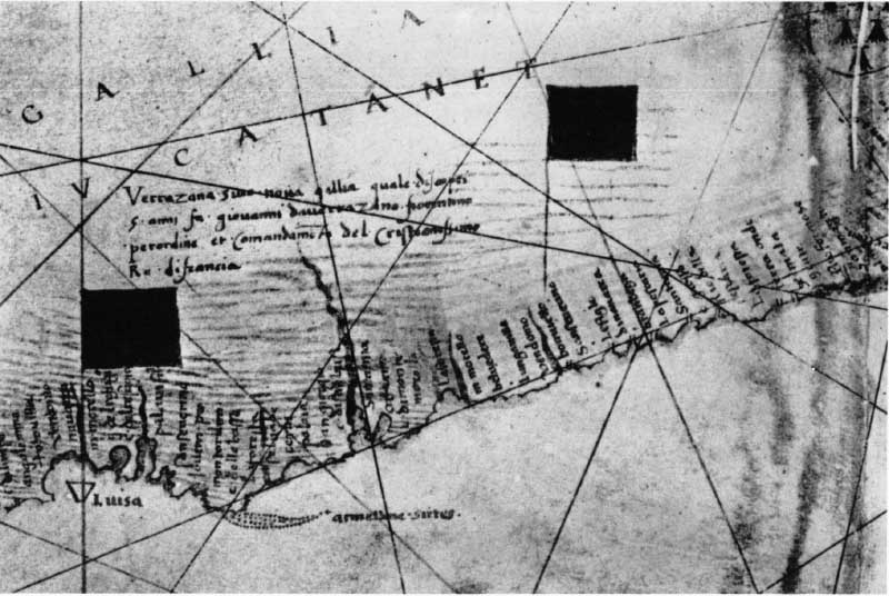
37. Detail of world chart by Gerolamo de Verrazzano, 1529, showing the New England coast. (Text p. 68)
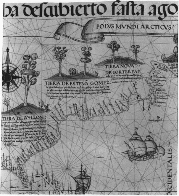
38. Detail of Ribero world map, 1529, showing the New England coast. (Text p. 72)
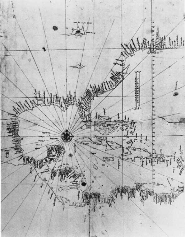
39. Map of the Caribbean and East Coast of North America by Alonso de Santa Cruz, circa 1567. (Text p. 73)
40. Detail showing the New England coast, from the map of North America and the North Atlantic by Diogo Homem, 1558. (Text p. 74)
41. Port St. Louis (Plymouth Bay, Massachusetts) from Champlain’s Voyages, Paris, 1632. (Text p. 75)
42. Port Fortune (Stage Harbor, near Chatham, Massachusetts) from Champlain’s Voyages, Paris, 1632. (Text p. 75)
43. Manuscript map by Champlain, “Description des costs…de la nouvelle france…,” 1607. (Text p. 76)
44. Captain John Smith’s map of New England, 1614, published in 1616. (Text p. 79)
45. Detail of a map of Chesapeake Bay to Penobscot Bay by Adriaen Block, 1614. (Text p. 81)
46. Detail of a map of New Belgium and New England from W. J. Blaeu’s Novus Atlas, Amsterdam, 1640. (Text p. 83)
47. Detail of the New England coast from the N. J. Visscher copy of Jansson. (Text p. 83)
48. Detail from “A New Map of New England,” by John Thornton et al., London, circa 1685. (Text p. 85)
49. Detail of “A Large Draught of New England New York and Long Island by John Thornton,” from The English Pilot, The Fourth Book, 1706. (Text p. 89)
50. Detail of a “Correct Map of the Sea Coast of New England,” 173 1, from The English Pilot, The Fourth Book. (Text p. 89)
51. Detail of a “Map of the Coast of New England from Staten Island to the Island of Breton…Capt Cyprian Southack,” from The English Pilot, The Fourth Book. (Text p. 89)
52. Detail of the Massachusetts coast from Cyprian Southack’s New England-Coasting Pilot, circa 1730–1734. (Text p. 89)
53. Nathaniel Blackmore’s “Plaine Chart of the Coasts on the Province of Nova Scotia et L’Accadia,” 1714/15. (Text p. 91)
54. Map of New England by Dr. William Douglass, circa 1752. (Text p. 94)
55. Detail of Thomas Jefferys’ “A Map of the most inhabited part of New England,” first published in 1755, from the edition of 1775. (Text p. 94)
56. Plan of the Town of Pownall, Kennebeck Purchase, by Thomas Johnson, 1763. (Text p. 96)
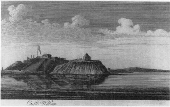
57. View of Castle William, Boston Harbor, from The Atlantic Neptune. (Text p. 104)
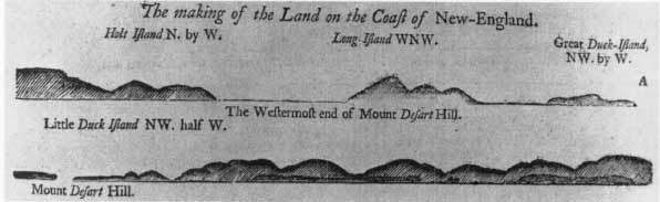
58. Shore views in the area of Mt. Desert, Maine, from The English Pilot, The Fourth Book. (Text p. 104)
An unusual collection of maps and charts, chiefly of Maine, was made for or collected by Sir Francis Bernard, one of the last royal governors of Massachusetts (1760–1769). It is now owned by Dr. J. G. C. Spencer Bernard, a descendant of Sir Francis, Nether Winchendon House, near Aylesbury, Bucks.4 Among these maps are sets of large-scale road maps from Boston to Saint George’s Fort in Maine, and from Boston to Albany, N. Y., varying from one to two miles to the inch. On some the crossroads, meetinghouses, churches, and taverns with the owners’ names are given; they are the most extensive detailed road surveys preserved from the colonial period. In 1762 the Massachusetts assembly voted to compensate Sir Francis for various expenses he had incurred by awarding him “the Island of Mount desart lying north eastward of penobscot bay.…” Sir Francis, not averse to augmenting his wealth by land speculation, resolved to “people one spot of the Vast Wast of his Majesty’s Dominions.”5 He had the whole region surveyed and mapped, including the coasts on either side of Mt. Desert and the upper reaches of the Penobscot to its source. Several charts of the coast, from Portsmouth to Passamaquoddy, give unusually detailed information; other maps give surveys of newly created townships. Thomas Pownall, an earlier governor who was interested in the mapping, states that he made use of Governor Bernard’s surveys of the Maine coast in making his map of the “Middle British Colonies,” published in 1776.6
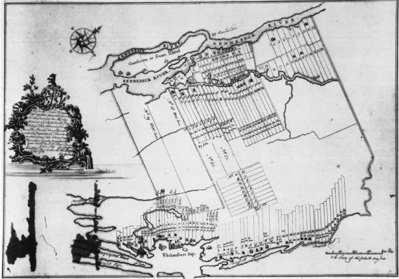
In the Bernard collection is a “Plan of ye Town of Pownall…12 Nov: 1763” with “Tho Johnston Sculp” below the title within the folds of the cartouche that may be Johnston’s engraver’s copy of a detailed plan showing about 280 lots, ranging from eight to 3,200 acres, between the Kennebeck River and Swan Island to the west and Witcheassett [Wiscasset] Bay and Sheepscull River to the east (Figure 56). No engraved copy of this plan has so far been located. Pownall or Pownallborough was part of the settlement effort of a group of wealthy and influential Boston merchants, inheritors of the Plymouth Colony grant of 1629 on both sides of the Kennebec River. Calling themselves the Kennebec Company, they had activated in 1749 the old grant and had for years engaged in a bitter legal struggle with other settlers and owners owning deeds of grant from the Indians. In 1763 the legal battle was at a crucial point; the Kennebec Purchase proprietors, including such well-known men as Thomas Hancock and James Bowdoin, were forcing the issue up to the King’s Privy Council in London. Three days before the date of this map, on 9 November 1763, the Proprietors gave Lot 21 of 1,500 acres in Pownall to the governor, Francis Bernard.7
What influence the Proprietors hoped to gain through Sir Francis is not known; but the land speculators as early as 1754 had begun to employ the Boston engraver Thomas Johnston to make maps for them.8 In 1752 Johnston had engraved a map for the opposing faction showing their claims,” A True Coppy from an Ancient Plan.” In 1754 Johnston published a “Plan of Kennebeck and Sagadahock Rivers” for the Proprietors. The next year, beginning their legal fight in London with the aid of Florentius Vassall, a Proprietor, they enlisted the aid of John Green, whose real name was Braddock Mead, to supervise the making of a map drawn by Johnston. Mead employed Thomas Kitchin, engraver and Hydrographer of the King. Kitchin unfortunately engraved “Sagadahock R” at the mouth instead of “Kennebeck R.” This alarmed and angered the Proprietors, who felt that their long and costly plans might be jeopardized, as their grant was for land either side of the Kennebec. Their London agent represented their complaint to Green/Mead as coming from Johnston (see Appendix C). Green earlier that year had made a map of Nova Scotia showing the Maine coast with an accompanying Explanation carefully explaining his sources. He had also added many details in the delineation of the Maine coast to Jefferys’s map of New England, published later in November 1755, the month after the Vassall-Green correspondence. He apologized for the “Sagadahock R” insertion but defended its correctness by reference to earlier writers, going back to Hakluyt and Gosnold.
6. The Atlantic Neptune
With the dark clouds of rebellion in the colonies impending the British Admiralty and the Lords Commissioners for Trade and Plantations realized the importance of official support for better charts of the coast. For over a decade before the Revolution naval ships were assigned to surveys along the eastern seaboard, with particular emphasis on the St. Lawrence, Newfoundland, and the maritime provinces. The Board of Trade was concerned with coastal surveys as well as its primary interest, general surveys of the King’s Dominions. In March 1764, the King, at the request of the Lords of Trade, appointed Samuel Holland Surveyor General of the Northern District, north of the Potomac,9 and later the same year William Gerard De Brahm Surveyor General for the Southern District. In the same year De Brahm, a former Captain Engineer of Charles VII who had emigrated from Germany with other Protestants to Georgia in 1751, immediately began a survey of the east coast of Florida.1 Holland, already Surveyor General of Canada, left Quebec for surveys of Prince Edward Island in late September 1764. Holland, described in the commissioners’ memorial to the King as “a brave and active officer, able engineer and a skillful surveyor,”2 was also tactful in his relations to his superiors and assistants, unlike De Brahm and DesBarres. Samuel Jan Hollandt, who later anglicized his name, was born in Nijmegen, Holland, in 1728, became a lieutenant in the Dutch artillery, went to England in 1754, and was appointed lieutenant in the 60th Regiment of Foot in the Royal Americans. He served under Wolfe, who regarded him highly as an officer and surveyor-mapmaker. He contributed to the early training in surveying methods of James Cook and Thomas Hurd, who later became Hydrographer of the Navy.3
Not until July of 1770 had Holland finished his surveys in the settled parts bordering the Gulf of St. Lawrence; by December he had established his headquarters near Portsmouth, N. H., and sent a sketch map of Maine to Lord Hillsborough.4
Holland’s chief deputy surveyors at this time were George Sproule, Ensign in the 59th Regiment and later Surveyor General of New Brunswick, Thomas Wright, Thomas Wheeler, later Surveyor General of Prince Edward Island, James Grant, Charles Blaskowitz, and Thomas Hurd, whose names are on manuscript surveys of the Maine-Massachusetts coast in the Public Record Office, British Museum, and the Hydrographic Department of the Navy at Taunton. Hurd and Wright, acting as deputies of Holland, conducted the survey from the St. John River to Passamaquoddy. Holland apparently began his surveys at the St. John River and proceeded methodically down the coast to Penobscot Bay, Casco Bay, Portsmouth, and Boston Harbor. By 1774 he had completed his surveys of Boston, as a notice in the Massachusetts Gazette for Thursday, 5 May 1774 announced “that an exact survey of our Sea-Coast from the Bay of Fundy to this Port (so much and long wanted) is at length happily accomplished under the Direction of Capt. Holland; and that a further survey, under the same Direction, from Boston to Plymouth by Mr. Wheeler, and from Plymouth round the Cape to Rhode Island Government, by Mr. Blaskowitz, is intended; which when done will finish the whole coast of this Province, and will be of great advantage to the Trade in the safety of Navigation. Mr. Wheeler and Mr. Blaskowitz came to Boston last Week and are immediately to proceed on said Survey.”
As Surveyor General, Holland’s duties and interests extended beyond the coast to the topography of the interior; his published charts in The Atlantic Neptune are frequently rich in details of roads, houses, swamps and even ownership boundaries, as in the charts of Portsmouth, Cape Ann, and Boston. For offshore soundings Lieutenant Henry Mowatt, R. N. of Canceau, assigned to work with him from 1764, must be largely responsible, although the records of other naval offshore surveys were used and sometimes acknowledged on the charts. At first Mowatt was intractable and noncooperative; but after an admonition from his superiors, aided by Holland’s genial levelheadedness, the two worked well together.
Little is known about Holland’s surveying instruments and methods; the voluminous files of his reports and those of the other contributors to The Atlantic Neptune have not yet been adequately examined. Manuals of marine surveying were yet to be written during this period, although it is clear that the three chief contributors to the charts of The Atlantic Neptune, DesBarres, Holland, and De Brahm, used the latest scientific methods and instruments with the exception of the chronometer, recently perfected by Harrison. De Brahm gave a full list of stores he required on the schooner he used for his Florida surveys.5 Both Holland and DesBarres refer to their use of the plain table and theodolite for triangulation; both must have used octants, Hadley’s improved quadrant, for the calculation of latitudes and longitudes, an important part of the Admiralty’s instructions. DesBarres describes in a letter of May 1765 to Colville in considerable detail his method of corroborating coastal triangulation by actual measurements with a dipsey or fishing line, carefully measured in fathoms, between headlands and checked by chain measurements ashore. “The sloop was employed…to the distance of ten or twelve miles [offshore] laying down soundings in their proper bearings and distance, remarking everywhere the quality of the bottom. The shallop [an open boat] was, in the meantime, kept busy sounding and remarking about the headlands, islands, and rocks in the offing; and the boats within the indraught, upwards, to the heads of bays.”6
However much De Brahm, Holland, and DesBarres, their assistants, and other contributors labored with meticulous care in gathering and compiling data, drafting the charts on drawing boards, and undergoing the dangers and obstacles which resulted in injury and death to some of these, it is to DesBarres that the final credit must go for actual production of the charts in The Atlantic Neptune and their superb craftsmanship. Irascible and unreasonable at times he was; but his tremendous energy, persistence, technical skill, and artistic brilliance resulted in the most magnificent work of its kind yet achieved. Thoroughly trained in his native Switzerland by notable mathematicians, he went to England and was admitted to the Royal Military College at Woolwich. Like Holland, he received a commission in the 60th Regiment of the Royal Americans and served during the French and Indian Wars under Wolfe. His impolitic attitude toward his superiors, in contrast to the feeling of reliability that the even-tempered Holland inspired, slowed his advancement. In 1764 he was employed by the Admiralty to chart the coasts of Newfoundland, Cape Breton Island, Nova Scotia (where he later became Governor General), and adjacent islands and coasts.7
In 1774 DesBarres went to London to supervise the editing, preparation, engraving, and publication of the surveys begun ten years before for the Royal Navy and for the Board of Trade. By 1776 he had twenty assistants in two London houses coordinating and drafting the charts for engraving. After 1781 the work slackened, but by 1784 well over 250 charts, profiles, and views had been engraved. About 1777 DesBarres began to publish a collection of the individual charts with the title The Atlantic Neptune, later expanded to three volumes with tables of contents and remarks. None of these sets, however, contains all the charts and views; the volumes were usually composed of charts selected for a particular purpose, assignment, or mission.8
The revision of the plates was continuous; many charts are known in four, six, or even ten states. Additions and revisions continued even after the active production of charts ended in 1784. The first impression or state of a chart is often without imprint or date; later states stipple or redraw the shoals, update the soundings, indicate channels into harbors, show anchorages, and add place names along the coast. The earliest impression of the chart of the coast from Marblehead to Hampton Bay, for example, has the waterline of the coast and some hills, roads, buildings, and property lines, evidence of Holland’s topographical interest, but no soundings north of Cape Ann. Later states revise the waterline, add soundings both north and south of Cape Ann, and markedly increase the topographical features to the interior with delicately drawn marshland, elevations and relief, vegetation, settlements, and roads with adjacent buildings and boundary lines with the owners’ names. The two-sheet untitled Massachusetts Bay chart is found in six states, with the imprint date of “April 29th 1776” in the first state, and with latitude marked and noted in minutes from [41°] 53′ to [42°] 40′; the second state deletes the minute numbering and changes notations to every five minutes [41° 55′, etc.]; the last state changes the imprint date to 1 December 1781. The later states of some charts have overlay corrections pasted on or, as in some copies of “A Plan of the Posts of York and Gloucester,” which shows the location of the fortifications at the time of the surrender on 17 October 1781, a hinged overlay with “The Position of the Army between the Ravines on the 28th and 29th of Sept. 1781.” No previous charts or maps of North America were so carefully and frequently revised as those of The Atlantic Neptune.
Comparison of the profiles and views shows that many of them also underwent revision, sometimes a series of revisions, on the same plate.9 Different states of the same profile usually show an increase from comparatively simple delineation of the physical features of landscape to greater complexity and elaboration. Additions may increase the detail of cliff or shore forms; of trees and other vegetation; of houses; of ships and craft of various types, often with the erasure of vessels on the previous state; and of coloring. The inset of a view on a chart may be erased and a new view from a different point of view engraved, as that of the city of Charles Town in “The Harbour of Charles Town in South Carolina.” These reengravings, skillful and elaborate though they are, do not always improve the accuracy of the work. The later states of profiles tend to exaggerate and increase the height of the cliffs, as in some of the Nova Scotia plates or of sand dunes in those of Sable Island. The New England coast does not have as many profiles and views on separate plates or as insets on the charts as do those areas surveyed by DesBarres, who states that such sketches regularly accompanied his hydrographic work. Either Holland did not have trained draughtsmen for this work on his staff or did not put the emphasis on coastal sketching that DesBarres did. The views of Portsmouth and of Boston and its harbor approaches are excellent; some of them DesBarres supplied from other sources. The views and profiles included in The Atlantic Neptune were fundamental aids, before photography and wireless, to vessels approaching a shore in identifying their location. They not only surpassed previous work but have beauty and charm that give intrinsic pleasure to the viewer (Figure 57). The improvement in quality and practical usefulness can be seen by comparison with a sheet of profiles of the New England coast in The English Pilot: The Fourth Book (Figure 58). The development from the usual inaccurate early charts to the professional accomplishment of Des Barres and his assistants in the ten years of their work from 1774 to 1784 is impressive. Though the Blaeu-Jansson-Visscher series of New England maps remain unsurpassed for their combination of decorative charm and historical interest, the charts of The Atlantic Neptune are, at their best, preeminent during the colonial period for scientific accuracy and artistic craftsmanship.1

APPENDIX A
New England Colonial Cartography: A Selected Bibliography
No adequate study of New England maps exists; the sixteenth century has fared better than the later periods. Useful catalogues of some major map collections have been published; but other collections and items are uncatalogued. Short-title lists, characteristic of most catalogues, often do not indicate what is valuable to know about a map: is the information new or is it plagiarized from some already outdated production; how can one distinguish between the first edition and the tenth; what manuscript sources were used in the construction of a printed map; what are the improvements in accuracy and detail over previous maps? These and other data are valuable not only to the map student and collector but to the historian, geographer and scholar in other disciplines, often confused by the complexities of the subject. The field is not, however, entirely untilled; there are excellent studies of individual New England and local maps or of groups of maps, referred to and used in this essay. Some general contributions to the subject have been published, including those here listed.
Johan G. Kohl, “A History of the Discovery of the East Coast of North America, Particularly the Coast of Maine…to 1578,” Maine Historical Society Collections, 2nd Ser., i. (1869), 7–497.
Hyman Askowith, “Early Explorations of the New England Coast,” New England Magazine, N.S., xxviii. (1903), 19–32.
Julian Tuttle, “Early Manuscript Maps of New England,” Publications of the Colonial Society of Massachusetts, xvii. (1915), 112–115; this is primarily a discussion of early references to the lost maps of New England by James Taylor (William Reed, 1665) and by Cotton Mather (1676).
Henry Harrisse, The Discovery of North America…with an Essay on the Early Cartography of the New World…before the Year 1536 (London, H. Stevens & Sons, 1892).
Justin Winsor, Narrative and Critical History of America, 8 vols. (Boston, Houghton Mifflin Company, 1884–1889), with numerous critical essays and facsimiles scattered through the volumes. Critical bibliographical lists of cartographical studies published since Winsor’s basic work are found at the end of chapters in Samuel Eliot Morison, European Discovery of North America: The Northern Voyages A.D. 500–1600 (New York, Oxford University Press, 1971).
W. F. Ganong, Crucial Maps in the Early Cartography of the Atlantic Coast of Canada, ed. by T. E. Layng (Toronto, Toronto University Press, 1964), includes the New England coast in an examination of maps before 1600.
Isaac N. P. Stokes, Iconography of Manhattan-Island, 1498–1909, 6 vols. (New York, R. H. Dodd, 1915–1928), has useful reproductions and critical comment in Volume II on many early maps that include the New England area.
Douglas R. McManis, European Impressions of the New England Coast 1497–1620 (Chicago, Chicago University Press, Department of Geography, Research Paper No. 139, 1972), discussed various contributions of early maps with apposite quotations from contemporary narratives. W. P. Cumming, British Maps of Colonial America (Chicago, University of Chicago Press, 1974).
Jeannette D. Black, The Blathwayt Atlas Volume II: Commentary (Providence, Brown University Press, 1975), is a long-awaited and invaluable study of late seventeenth-century maps in the Blathwayt Atlas, reproduced in Volume I.
W. W. Ristow, Guide to the History of Cartography (Washington, D. C, Library of Congress, 1973), 96 pages, is a useful annotated list of references on the history of maps and map making that includes other general works on American historical cartography and catalogues of some major map collections.
David B. Quinn, North America from the Earliest Discovery to the First Settlements: The Norse Voyages to 1620 (New York, Harper & Row, 1977), gives a scholarly and informed analysis of early maps, with references.
APPENDIX B
This table lists the names for the New England coast derived from the Gómez voyage of 1524–1525 as given by three contemporary royal cosmographer-cartographers who had access to the official records in the Casa de Contratación in Seville. Diego Ribero made the Castiglioni chart shortly after Gómez’s return to Coruña and the world chart of 1529 now in the Vatican after his appointment as examining pilot in the Casa de Contratación. Alonso de Chaves, examining pilot with Ribero and later cosmographer major, wrote his Qvatripartitu[m] en Cosmographia pratica (circa 1539), containing a detailed description of the seacoasts of the world. Alonso de Santa Cruz, cosmographer to his Majesty, wrote the Islario General, extant in several copies (1541–1545) that contains regional maps apparently similar in information to the lost world chart of 1536 by Chaves; Santa Cruz’s map of the western hemisphere between 10° and 50° N.L. records the Spanish nomenclature of the coast at the time of his death in 1567. Although other Spanish and European maps of the period show numerous differences in the delineation of the coast and in names, probably no surviving records are more authoritative than these for Gómez nomenclature.
The most elaborate and carefully documented attempt to identify the Gómez names with their modern equivalents is by Professor W. F. Ganong, Crucial Mafs in the Early Cartography and Place-Nomenclature of the Atlantic Coast of Canada, ed. T. E. Layng (Toronto, University of Toronto Press, 1964), 170–178, who also lists previous attempts at identification by scholars.
Samuel Eliot Morison, whose thorough knowledge of the coast as a navigator is unexcelled, has identified the location of the Gómez names in his The European Discovery of America: The Northern Voyages (New York, Oxford University Press, 1971), 329–331. Some of these identifications south of Penobscot are difficult to accept, however, since he makes “Cabo de Santiago” Cape Ann and “Baya de S. Xpoual” Ipswich Bay and pushes other locations northward accordingly. Cape Ann is unlike the cartographical representations as well as the description of Chaves, who had access to firsthand reports and who describes “Cabo de Xpoual” as the most prominent cape on the whole coast, with a great bay to the west and southwest of it. Morison identified “arcipielago de Estevan Gomez” as Muscongus Bay, although the shape, location, and Chaves description correspond to Casco Bay to the south.
The manuscript of the Chaves Qvatripartitu[m] en Cosmographia pratica (1539) is in the library of the Real Academia, Madrid, Nọ 9–14–1–2791. It has not, to my knowledge, been published although I. P. N. Stokes, Iconography of Manhattan-Island (New York, 1915–1928), ii. 40 describes it with an accompanying table summarizing briefly the deroteiro for the east coast; and Ganong uses it. Chapter XIV, fols. 43–45v, “Tracta dela Costa del Norte,” has a description of the coast from “Baia Santa Maria” (Chesapeake Bay with, probably, inclusion of the North Carolina sounds) to “Isla de sant Juan,” an imaginary island south of Cape Breton, on fols. 43–44, followed by a rutter giving directions, distances, and latitudes on fols. 44–45v. The table given above translates the description of the coast on fols. 43–44 and adds to the right the latitudes from the second, usually repetitive, list. Other information from the second list not in the first is added in brackets below each item. The names given to the coast from the Cape of Florida to “Baya de Santa Maria” derive from the voyage of Pedro de Quexos; whether “Cabo de San Juan” (? Henlopen) is from Quexos or Gómez is uncertain. In order to fill the unexplored coast between the Chesapeake and “Cabo de Arenas,” the Spanish cartographers (or Gómez) apparently shortened the distance from Chesapeake Bay and lowered the latitude of Monomoy Point (38°20′ and circa ninety miles; actually 41°33′ and circa 500 miles), with the consequent necessity of extending the distances along the New England coast. This “compensation” was sufficient to place Penobscot Bay at 43°30′ (actual latitude 44°).
For checking the writer’s translation of the Chaves manuscript with his photographs of the original he is indebted to the kindness of Professor L. A. Kemp of the Spanish Department of Davidson College.
Gómez Nomenclature of the New England Coast
| Castiglioni-Ribero 1525 | Rome (Vatican) Ribero 1529 | Santa Cruz 1541 | Santa Cruz 1567 | Modern Name | Chaves, Qvatripartitu[m] en cosmographia practica [ca. 1539], fols. 43–44 | Chaves Latitudes |
|---|---|---|---|---|---|---|
|
(Latitudes and parenthesized additions from fols. 44–45v) |
||||||
|
R. del Sp:to Santo |
Chesapeake Bay (?and Carolina Sounds) |
From baya de santa maria to cabo de Sant Iuan they go east-northeast. The way is 20 leagues. The current flows north-northeast. |
36½° |
|||
|
bḁ de nra Senora R. salado |
James River Chesapeake (northern part) |
(This is a great bay with many islands; into it enter two rivers, the one being espiritu santo (? James R.), the other Rio Salado [?northern Chesapeake Bay].) |
37° |
|||
|
playa |
b:a de enganno |
|||||
|
C. de S. Juā |
a C. de sanJ |
c. de S:ioan |
? Cape Henlopen |
From cabo De San Juan to Cabo de Arenas they go northeast a quarter north. The way is 25 leagues. A strong current flows north northeast (24 leagues.) |
37° |
|
|
R. desdiago |
C. de las Arenas |
Monomoy Point |
From cabo de arenas to cabo de Santiago they go to the north a quarter northeast. The way is 30 leagues. The current flows north. |
38⅓° |
||
|
Cape Cod |
From cabo de Santiago to baya de Sant Xpoual they go west. The way is 20 leagues. In between there enters a small bay with a river in a southwest direction [?Plymouth]. (This cape is the one that extends farthest into the sea on the entire coast. It has on the west the bay of Sant Xpoual.) |
40° |
||||
|
b. de S. Xpoual |
b. de S. Xpoal |
Baia de S. Xpōual |
b.a de o S:xpbal |
Cape Cod Bay |
From baya de Sant Xpoual to Rio Sant Antonio they go north. The way is 20 leagues. The current flows northeast. [This is a very large bay and several rivers flow into it.] |
40° |
|
b. de S. Antonio |
b. de S. atonjo |
Rio de Sanantonio |
R. de S:anton |
Boston Harbor (Massachusetts Bay) |
From Rio de sant antonio to Rio de buena madre they go east-northeast. The way is 36 leagues, and the coast makes some coves [with] islands. The current flows northeast. |
41° |
|
Montaña Verde R. de buena |
Mōtaña verde R. de buena |
R. de buena |
Montañas verdes R de buena |
? White Mountains |
From Rio de Buena madre to |
41⅔° |
|
madre |
madre |
madre |
? Kennebec |
baya De Sant Juan Baptista they go northeast. The way is 10 leagues. The current flows northeast. (8 leagues. 38 leagues northwest of Cabo de Santiago. It is a great river between two capes and from it along the western shore begins the baya de Sant Xpoual and along the eastern shore of this river are some islets and reefs.) |
||
|
S. Juā baptista |
b. de sant o Jn baptista |
bḁ de S:ioan bb.a b. grande r. de montannas |
? Isles of Shoals ? Saco Bay River Saco |
From baya de sant Juan Bautista to cabo De arracifes [= reefs] they go eastnortheast. The way is 46 leagues. The current flows northeast. |
42¼° |
|
|
Rio seco |
r. de los farelones |
? River Saco |
(Rio seco 30 leagues northeast of baya sant Juan Batista, 20 leagues west of Cabo de arracifes.) |
43° |
||
|
montaña fremosa |
mōtanas |
White Mountains |
||||
|
C dearracifes |
C. basso |
Cape Elizabeth ? Pemaquid |
From Cabo de arracifes to Cabo de Santa maria they go east. The way is 20 leagues. In between is a great bay that extends to the |
43° |
||
|
arcipielago |
alsa piglago de muchas yaṣ |
Casco Bay |
northeast full of shoals and islets which they call arcipielago. The current flows east, (arcipielago probably extends [length] for 30 leagues and probably is 15 leagues wide.) |
|||
|
gulada |
? Meadows River |
|||||
|
C. De Santa Maria |
C. de S:Maria |
Cape Small ? Pemaquid Point |
From Cabo de Santa Maria to Cabo de muchas yslas they go east. The way is 26 leagues and all the coast is full of islets and shoals. The current flows east. |
43° |
||
|
S. Juan bautista |
? Isles of Shoals |
|||||
|
C. de muchas yslas |
C.de muchas islas |
C.de las muchas yaṣ |
Owls Head |
From cabo De muchas yslas to Rio de las gamas they go northeast until entering it and the way is 15 leagues. The current flows northeast. (8 leagues to the mouth of Rio de las Gamas; the cape is surrounded by shoals and islets.) |
43° |
|
|
unnamed bay and river |
R. de las gamas |
R: de guamas |
Penobscot |
From Rio de las gamas to baya de la ensenada [Bay of the Rounded Gulf] the coast goes east a quarter northeast. The way is 125 leagues and the coast has many harbors and rivers in between. The current flows northeast. (This is the largest river that is noted along all this coast. At the mouth it is 10 leagues wide. It is full of islets and reefs; it enters from the north.) |
43½° |
APPENDIX C
The Vassall-Green [Mead] Correspondence; the Johnston Maps of the Kennebeck Purchase
In the Kennebec Purchase Papers in the Maine Historical Society are a letter from John Green to Florentius Vassall and one from Vassall, a proprietor of the Kennebeck Company and its London agent, to Green, with a copy of the latter. The two letters are here printed; the Vassall copy (identical with the original except for typographical differences) is transcribed here because it adds a postscript written four days later.
Vassall’s letter is interesting because it casts light on the devious methods of the Proprietors; Green’s letter is important because it sheds further light on the obscure career of one of the ablest geographers in eighteenth-century map making. His care in presenting the sources of his information, his high professional integrity in his work, his interest in establishing correct coordinates, and condemnation of lax methods by geographers and marine surveyors are here evidenced. As the geographer for Thomas Jefferys, he did much to raise Jefferys to a place of preeminence among British map makers of the period.
John Green is an alias; the geographer’s true name was Braddock Mead, an Irishman whose bigamous or trigamous misadventures had caused him to assume different names and go into hiding to avoid hanging. Brilliant but erratic, his caustic comments on the failings of other map makers did not endear him to his contemporaries. His own personal failings, however, did not affect the high quality of his work. Less than two years after his letter to Vassall, Mead married again; three months later he committed suicide. See G. R. Crone, “John Green, Notes on a Neglected Eighteenth Century Geographer and Cartographer,” Imago Mundi, vi. (1949), 86; G. R. Crone, “Further Notes on Bradock Mead, alias John Green, an eighteenth century cartographer,” Imago Mundi vm. (1951), 69–70; Cumming, British Maps, 45–47, 93. On the Proprietors of the Kennebeck Purchase see the text and accompanying footnotes.
Green to Vassall: enclosed with Vassall’s letter to the Proprietors dated 30 October 1755. Original: Kennebec Purchase Papers, Maine Historical Society.
16 Octṛ 1755
Sr
I am very sorry that I cannot obey yor summons immediately. I am naturally an invalid & the late weather has confined me at home these 3 weeks. As soon as I dare venture abroad I will wait on you. In ye mean time with regard to Mṛ Johnson’s complaint I must observed, that he might have been Satisfyd with ye apology I made you, in case you acquainted him with it; and ye very objection, which he makes in your letter ought to have convinced him that it was ye fact, for tis absurd to call ye River, Sagadahok, & ye Bay Kennebek, after ye name of a River at a great distance. Besides the third article of ye Explanation in my draught makes Sagadahok a Branch of ye Kennebec; and his own printed draught has ye same mark of falls, below Tahonnek, which are found in mine.
But supposing I had ordered ye Engraver to add ye R to Sagagahok, he might have spared ye suggestion of my being influenced by any person here. As he saw I was somewhat conversant with Geogỵ by ye plan, he might have imagined that I had some authority for it; and I wonder he shoud not know that the first printed treatise we have, which speaks of ye River in question, calls it Sagadahok, & ye Kennebek a branch of it. This is an ancient testimony of ye Indians themselves to be seen in Purchas Vol. 4 p 1874, an authority much superior to ye Oaths of ye oldest Inhabitants, wch only report a late usage. He might likewise have seen that it is named Sagadahok, by Captṇ Smith, the first N. Engl. Historian.
The truth is sr it crept in by ye Engravers mistake as I told you, when you mentioned it. I know there was a dispute between the proprietors of Lands & therefore intended only to name ye mouth of ye River, if I had designed any thing else, I might as well have had ye name inserted within the River, & not so far out. This, with ye authorities above quoted, I hope will make Mr Johnson easy, having had no intention to make him father any thing, wch. was either wrong or agṭ his inclination. Tis a thing I am extremely averse to; & altho I have altered ye Coast entirely to ye East of Pemmaquid, yet I did not scruple to give it as his, because I was sure his was not injured by it; tho Mṛ Hazzen’s survey, which I have restored, was extremely injured by his draught.
I intended to have written to you on occasion of ye small Map of N. Englḍ & inserted in his plan, which it contradicts in Every respect as to ye Situation of places, and therefore beg ye favor of you to renew your request, when next you write to America, for ye Obsns. of Latḍ if any have been made; and to recommend above all things ye use of taking altitudes, as ye only possible means of rendring surveys of service to Geogrṣ and perhaps of making a Geogr consistent wth himself. I am
Sir
Yor
most Obedt
humble servt
Jno Green
Florentius Vassall to the Proprietors of the Kennebeck Company
Argyle Street. London ye 30th 8br 1755
Dear Srs,
I have not much to add to my last to you except to acknowledge the recṭ of the Compys & your several letters in August, but to tell you Lord Hallifax has now the state of our case & the attorny Genls opinion in his hands for his perusal, but I think you may depend nothing can be done till the tryal is brought here; I inclose you Mr Greens letter (the Author of ye phamplet & plan sent you) by which you will see I found the faults with his map as soon as I saw the map, he Imagins its Mr Johnsons complaint & I have not undeceived him, as p[er]haps the Company may think it proper to plan a Letter to said Mr Green as from Mr Johnson & get him to sign it in order to clear the dispute up or to convince Mr Green; its not impossible the person you hints at may have had some hand in it with the Graver but I fancy not with Mr Green—I observe what great Efforts are made by the people of New England p[articu]larly the Massachusetts, as a New England man, I am absolutely against men or Governors goeing to the Westward of Crown point & there only as aiding not as Principals, what is to be come of you if your best men should be cut off, how are you to defend your own frontiers; what have you to doe with the falls of Niagra or the lands on ye Ohio (which I think has been all a long a Job). Why will you not promote Expeditions from your own frontiers which will incourage your own remote setlers & have the soldiers pay spent in yor own Country a thing of no small consiquence; instead of this you suffer your own settlements to be broke up for want of protection, to protect Countrys richer & more able than yourselves, be Patriots to your Country, the Comon cause might be as well p[er]haps better served if the whole forse of New England was to be imployed in Expeditions from their own frontiers towards or to & on the banks of the river Sṭ Lawrence.
I can’t add being just interrupted with to me the most agreable News I could possibly hear, our Brave New Englands frds having gained a corn-pleat victory over the french near Lake Sacrament God prosper them in [a]ll their undertakenings shall Ever be the prayers of Gentṇ
Yor most obedṭ Serṭ
Flo. Vassall
Coppy
P.S. of 3 Novṛ
I wish you would perswade your Governr or Legislature to apply here for some hundred of swivle guns, they would be granted on asking for the cost but a trifle they are easily Carrid even by men as the Wṭ need not exceed 60 or 70 lb. Each army ought to have 100 of them, no Indians or Canadians would long resist them if the French should get them your armys will be undone. I am convinced they will carry Victory to them who first gets them[.] Genḷ Johnsons camp had been [? un]tenable if ye French had carried 100 of these guns with them & were you [to] have a cart road how easily are they carried & even mounted on a cart to good effect.
To the Kennebeck Compy
Maps by Johnston and by Green
- relating to the Plans of the Proprietors of
- the Kennebeck Purchase.
- (1) “A True Coppy from an Ancient Plan, of E. Hutchinson’s Esqr:…& from John North’s Late Survey in 1752. Attestr: Thoṣ Johnston” [1753]
“Kennebeck River” joins “Androscoggin River” to make “Sagadhock River”; “Sagadhock River” repeated at the mouth.
The Plymouth Colony deed extends only on the “Kennebeck River” from “Negumkikee River” near the falls south to “Cobbiseconte Falls,” which is about sixteen miles above its juncture with “Androscoggin.”
- (2) “To his Excellency William Shirley.…This plan of Kennebeck & Sagadahock Rivers…Engraved Printed & Sold by Thomas Johnston…Boston…1754.”
“Kennebeck River,” into which “Sagadahock or Amorescoggin River” flows at Merrymeeting Bay, is repeated three times along its course into “Kennebeck Bay.” At top left is an inset of New England that Green [Mead] refers to in his letter disparagingly.
- (3) “A Plan of Kennebek & Sagadahok Rivers, with the adjacent coasts.…dedicated to…William Shirley Esqṛ Governor of Massachusetts Bay Prov:…By Thoṣ Johnston…14th. May 1755. by And: Millar…T. Kitchin sculpṭ”
This is the subject of Green’s and Vassall’s letters. “Kennebec” and “Sagadahok or Amorescoggin R.” join; the continuation is named “Long Reach” but flows into “Kennebek Bay,” where it is called “Sagadahok R.” It is this final name and its location that disturbed the Proprietors.
- (4) “To His Excelly. Frans: Bernard Esqṛ captain General & Governor in Chief in & over his Majestys province of ye: Massachusetts Bay…This Plan of ye Town of Pownall by order of ye proprietors of ye Kennebeck purchase…Boston 12 Nov: 1763 / Tho Johnston Sculp”
This manuscript plan, evidently presented to Governor Bernard, who had been given one of the lots by the Proprietors a few days before, shows the waterfront lots for real estate development in that area. See text, p. 96, and Figure 56. If Johnston, who signed himself the engraver, actually made a plate, it was probably published in Boston.
In 1755, the same year that the Kennebeck Proprietors’ map was engraved and published in London, Jefferys published two maps prepared by John Green [Mead] that included the Maine coast.
- (5) “A New Map of Nova Scotia and Cape Britain [later issues “Cape Breton Island”] with the adjacent parts of New England and Canada…May 1755…Thoṣ Jefferys.”
An accompanying pamphlet by John Green [Mead], An Explanation of a New Map of Nova Scotia…(London, T. Jefferys, 1755), noted carefully Mead’s sources with reasons for accepting them, and condemned the differences and errors of others. The map was included the same year in The Memorials of the English and French Commissaries, and in later atlases published by Jefferys. On it Kennebek R. joins Sebastekook R. Neither then nor after joining Sagadahok R. is the river named until the mouth, where Sagadahok is repeated. There is no Kennebeck Bay.
- (6) “A Map of the Most Inhabited part of New England…November 29th. 1755…by Thoṣ Jefferys.”
“Kennebek River” extends from “Richmond Fort” southward past Merry Meeting Bay and the juncture with “Sagadahok R” to “Long Reach,” a section of the river. But before entering the sea “Sagadahok or the Rivers Mouth” flows into “Kennebek Bay.” Mead appears to make an equivocal compromise, possibly reflecting his own uncertainty.
The writer is indebted to the Maine Historical Society for permission to print the Vassall-Green letters and to Rear Admiral William F. Royall of East Boothbay, Maine, who kindly called attention to the letters and furnished other information included in this appendix and in the footnotes.