The Atlantic Neptune
THE ATLANTIC NEPTUNE—the great marine atlas of the eastern seaboard of North America published between 1774 and 1803—contains about 145 views of the coast including full-page views of Quebec, Louisburg, Halifax, Sable Island, Annapolis Royal, Portsmouth, Boston, and New York.
The views appeared on forty separate sheets and as inset or profile views at the top or bottom of fifteen charts, which were mainly of the coast of Nova Scotia. The earliest states of the views were in large flat volumes. They next appeared in tall, narrow volumes where the charts and views were folded, and in the later state they were again bound in large flat volumes.
The first-issued volumes of Nova Scotia and New England contain no views other than those on charts, but soon separate sheets of views began to be added. Usually, there are two or more views on a sheet, and in the early states they are hand colored with the colorist occasionally introducing embellishments such as small sailboats or ships. The first state usually has no imprint, and some have the titles inserted by hand and are occasionally uncolored.
During the course of years, many of the early views were dropped or completely redrawn and new ones added, which in turn were dropped. As a result, no copy of The Atlantic Neptune contains all the views and some have few if any sheets of views.
Identifying the different states is at times difficult because the early state of a view was often erased from the copper plate leaving only the title, and then an entirely different later state was engraved on the plate. In one instance—“The Entrance of Boston Harbor” (S95) (d)—the small ship that is in the first state is not completely erased in an intermediate state and appears as a “ghost” ship sunk in the water, proving that the same plate was used. In the final state it is entirely removed and the view is completely different from the early state.
The basic purpose of most of these views was to assist navigators in identifying different parts of the coast when making a landfall. We might assume, therefore, that they are accurate pictures of the places shown. Most of the views were issued in two basic states. The earlier state usually shows a low-lying coastline with few, if any, ships. The later states have numerous ships in the foreground, and the coastline is made to look much bolder and more dramatic as though the artist drew the picture much nearer the shore. Many of these views are worked up in aquatint, and the result is a more appealing and decorative picture.
If the two states are compared with a modern photograph of the same coastline, it becomes readily apparent that the early states are usually an excellent representation of the coast, while the later states are apt to bear little if any resemblance to reality. Why were the later states substituted for the usually accurate early states?
The publisher of The Atlantic Neptune was an army engineer of Swiss origin named Joseph F. W. DesBarres. Educated at Basel and The Royal Military College at Woolwich, he became a lieutenant of the Royal American Regiment and was attached to General Wolfe’s staff in 1759, where he helped survey the St. Lawrence River before the siege of Quebec. In 1763, Admiral Spry realized the necessity of having the coast properly surveyed. From 1763 to 1774 DesBarres was employed by the Royal Navy in surveying the coast of Nova Scotia, New Brunswick, and Sable Island. In 1774 he was called back to London to publish his charts as well as those of Samuel Holland, another alumnus of Woolwich, who had been employed by the Lord Commissioner of Trade in surveying New England and the Gulf and River of St. Lawrence. In addition, he published the charts of numerous other surveyors who had surveyed the coast from New York south to the Mississippi River.
DesBarres’ arrangement with the Admiralty allowed him to sell both the individual charts and atlases for his own account. He depended on the success of this venture for his livelihood. It is my guess that he wanted to make The Atlantic Neptune saleable not only to mariners, but also to the general public. After he had been publishing the atlas for four years, he began to include views that had no navigational purpose at all—for example, his six small views of the environs of Boston, as well as plans showing the locations of troops or ships, such as the action of the British in the Hudson River in August of 1776 with the accompanying reference sheet which has the picture of the Phoenix and the Rose below the references. It was at this time he began to redraw his navigational views by making the land higher and more dramatic and introducing numerous ships. Those redrawn views certainly made the Neptune more attractive to the public at large.
The attached list includes the known views. Most appear in the two basic states. They are listed in the order in which they were normally indexed. The “S” number is the number used by the late Henry N. Stevens in indexing his great collection, which is now at the National Maritime Museum at Greenwich, England.
A List of the Views in The Atlantic Neptune
(Unless specifically noted, the views occur in two or more states.)
The charts and views are numbered in accordance with the Henry N. Stevens Bibliography on deposit at the National Maritime Museum at Greenwich, England.
Volume I
New Brunswick, the Bay of Fundy and the South West Coast of Nova Scotia
- S 3 View of a disabled ship with two ships standing by in a storm—15½″ × 9¾″—below the text of a sheet entitled “Utility of the Atlantic Neptune” (one state).
- S 11 Two Views on one sheet:
- (a) The North Point of Grand Manan Island—bearing ENE distant two Leagues—15¼″ × 11¼″
- (b) A View of Campobello at the entrance of Passamaquoddy Bay—14¾″ × 12″
- S 12 Two Views on one sheet:
- (a) Mechios River (Maine) near the Mills—in 9¼″ circle
- (b) A sketch of Mechios Mills—18¼″ × 14¾″
- S 13 The entrance of the River St. John—8¾″ × ½″ Inset View on the chart of the River St. John.
- S 14 Five Views on one sheet:
- (a) The Wolves—a cluster of isles lying SE off the entrance of Passamaquoddy Bay—14⅜″ × ½″
- (b) Grand Manan Island—the south point of Campobello Island—13⅞″ × 2½″
- (c) View of the shore westward of the St. John River—27⅞″ × 3⅝″
- (d) A View of the coast at the entrance of the River St. John—28″ × 4¼″
- (e) A View of the entrance of Passamaquoddy Bay—28⅝″ × 3¾
- In second state (a), (b), and (c) were engraved on one plate and (d) and (e) on another plate printed on separate sheets. The sizes remained as above.
- S 16 Four Views on one sheet:
- (a) Cape Blowmedown—7½″ × 5⅝″
- (b) Cape Split—7½″ × 5⅝″
- (c) Spencers Island and the Entrance of Minas Basin—16⅝″ × 6⅝″
- (d) Isle Haute and Cape Chignecto—16⅝″ × 8⅜″
- In later state the Views were engraved on a new plate. The sizes are: (a) 7½″ × 5¾″; (b) 7¼″ × 5¾″; (c) 16⅝″ × 8″; (d) 16⅝″ × 8″
- S 18 Six Views on one sheet:
- (a) The Isle Haute…and Cape Chignecto—19¾″ × 4″
- (b) The Western Cliff of Cape Dore—14⅝″ × 4⅝″
- (c) A View of Cape Baptist in the Entrance into the Basin of Mines—14⅝″ × 7¼″
- (d) A View of the Entrance into the Basin of Mines—14⅝″ × 3″
- (e) The Isle Haute—8⅝″ × 4⅜″
- (f) Cape Blowmedown—8⅝″ × 4⅜″
- S 20 Partridge Island (outside of Parrsborough N.S.) from the West 30½″ × 19⅜″
- S 21 Gullivers Hole—18¼″ × 6⅜″ oval on the chart Annapolis Royal…St. Mary’s Bay
- S 22 Five Views on two sheets:
- (a) The Entrance into Annapolis Basin—36⅞″ × 4¾″
- (b) The North Entrance of Grand Passage—36⅞″ × 8″
- (c) Eden and Gascoyne Rivers at the Entrance of the Basin of Mines—36⅞″ × 5¼″
- (d) View of Annapolis Royal—19½″ × 8¼″
- (e) The North Entrance of Petit Passage—19½″ × 8¼″
- The Views were enlarged and engraved on two new plates.
- Plate I (a) 39⅝″ × 6¼″, (d) 19⅜″ × 10⅛″
- Plate II (c) 36⅜″ × 7¼″,(b) 36¼″ × 8¼″
- The Views (a) and (c) on Plate I and (c) and (b) on Plate II were cut into separate plates and reduced in size:
- (a) 28⅞″ × 6¼″ and (c) 31¼″ × 7¼″ were printed on one sheet
- (e) 16⅛″ × 10⅛″ and (b) 21¾″ × 8¼″ were printed on another sheet
- S 23 Annapolis Royal—22⅜″ × 15″
- This View is an enlargement of the second state of S22 (d) (one state).
- S 24 Three Views on one sheet:
- (a) The South Entrance of Grand Passage—19½″ × 8¼″
- (b) Cape St. Mary N.E. one mile—19½″ × 8¼″
- (c) St. Mary’s Bay—19½″ × 8¼″
- The Views were re-drawn and re-engraved on a new plate in a new order: (c) 17⅜″ × 7⅜″, (a) 17⅜″ × 6½″, (b) 17⅜″ × 8⅞″
- S 30 Four Views on two sheets:
- (a) The South West Coast of Nova Scotia—41⅝″ × 3⅞″
- Cape Negro, Argyle Head
- (b) The South West Coast of Nova Scotia—33⅜″ × 4⅜″
- Cape Sable, Port Haldimand [Port Latour]
- (c) The Southern Seal Isle—7¼″ × 2½″
- (d) Boston Bay—45½″ × 4⅛″ The Garnet Head (The Gurnet, Plymouth Harbour), Cohasset Point
- S 31 Three Views on two sheets:
- S 38 Hopson’s Nose—13⅞″ × 3½″
- On chart of Prospect Harbour—Sambro Harbour
- S 39 Five Views on one sheet:
- (a) Cape Prospect—Cape Sambro—13¾″ × 2½″
- (b) The High Lands of Aspotagen—17½″ × 1½″
- (c) The Ovens at the Entrance of Lunenberg Bay—in an oval 6¼″ × 4¾″
- (d) Cape Sable bearing NNW—The Entrance of Barrington Bay—20½″ × 2½″
- (e) Cape Sable bearing NExN—20½″ × 3¼″
Volume II
- S 45 Two Views
- (a) View of the lighthouse (Sambro) SE one mile distant in oval—15¼″ × 13″
- (b) Panoramic View of the entrance to Halifax Harbour, in oval panel—50⅝″ × 4⅛″
- Both these Views are on the chart of Halifax Harbour. In the later states (b) is re-engraved in an oblong panel—51¼″ × 41/16″
- S 47 “A View of Halifax in Nova Scotia, taken from the Eastern Shore”—19¼″ × 13¼″
- In the first state the title reads “Halifax, in Nova Scotia.” No alterations appear in the plate.
- S 47* “A View of the Town and Harbour of Halifax, taken from the Dartmouth Shore”—22⅜″ × 14¾″
- No alterations appear in the plate.
- S 48 Six Views on one sheet:
- (a) A View from the Southeastward of Halifax Harbour—25⅜″ × 2⅜″
- (b) Appearance of the Shore 4 or 5 Leagues to the Eastward of Halifax Harbour—25⅜″ × 2¼″
- (c) A View taken 4 miles off Shore of Halifax Harbour—23⅛″ × 2½″
- (d) Sambro Light House bearing west—22″ × 2¾″
- (e) Sambro Light House, south east distant one mile
- (f) Chebucto Head, bearing north—25¾″ × 2⅞″
- S 49 Two views
- (a) Egmont Harbour—view of inner Harbour Small circular View 4″ in diameter
- (b) Egmont Harbour—View of entrance to Harbour 17⅜″ × 3⅜″
- Both Views on chart of Egmont [Jeddore]
- S 50 Two Views
- (a) The Entrance of Keppell [Owl’s Head] Harbour
- (b) Cape Southampton
- Two Views on the bottom of the chart showing Keppell [Owl’s Head] Harbour…Deanes [Southampton] Harbour.
- S 51 Six Views on one sheet:
- (a) View of Cape Egmont and Winter Rock—18⅛″ × 4⅜″
- (b) Entrance of Egmont [Jeddore] Harbour—18⅝″ × 3⅛″
- (c) The Entrance of Keppell [Owl’s Head] Harbour—16¾″ × 2½″
- (d) Fall of Hinchenbroke River—in circle 4″ in diameter
- (e) The Entrance into Chisetcook Inlet—16¾″ × 3½″
- (f) Dartmouth Shore in the Harbour of Halifax—16¾″ × 6″
- S 52 “Cape Spry, Beaver Islands Etc.” Oval View—29½″ × 3¼″ at the bottom of the Chart Spry Harbour…Beaver Harbour, etc.
- S 55 Berry Head…& White Head Island—25″ × 2⅝″
- Across the top of the Chart of Torbay
- S 56 Cape Martingo…White Head Island—18½″ × 3″
- Across the bottom of the Chart of White Haven
- S 57 View of Port George taken from the top of Binney Isle—18⅞″ × 3″
- Across the bottom of the Chart of Canso Harbour, Port George
- S 58 Crow Harbour—7⅜″ × 1½″
- Between the description and chart of Crow Harbour
- S 59 View of Cape Round—20⅞″ × 2½″
- Across the bottom of the Chart of St. Peter’s Bay
- S 60 Milford Haven [Guysborough]—18¼″ × 3½″
- Across the bottom of the Chart of Milford Haven In later states the view was completely re-engraved and measures 15½″ × 4⅜″
- S 61 Eight Views on two sheets:
- (a) Appearance of the Land from the White Islands to St. Mary’s River—40″ × 2⅛″
- (b) The Entrance of Milford Haven—15¼″ × 4⅛″
- (c) The entrance of Port Bickerton—15¼″ × 5⅛″
- (d) A View taken off the entrance of Beaver Harbour—20″ × 4⅛″
- (e) A View taken in the Offing of Beaver Harbour—20″ × 4⅛″
- (f) Appearance of the shore to the Westward of Canso—19⅝″ × 2⅜″
- (g) The Beaver Islands—39″ × 6⅜″
- (h) Appearance of the S.E. Point of Nova Scotia taken from Canso Island—39″ × 6⅜″
- S 64 Six Views on one sheet:
- (a) A View of Louisbourg Harbour—29¾″ × 4¼″
- (b) A View of the shore to the westward of Gabbarrus [sic] Bay—19¼″ × 3⅛″
- (c) West Shore of Richmond Isle [Madame Island] (oval) 4¾″ × 3¾″
- (d) A View of the S.W. Shore of Cape Breton Island—25½″ × 2⅞″
- (e) Ramea Isles on the S.W. Coast of Newfoundland—12¼″ × 7⅝″
- (f) Santa Maria Island (Azores)—12″ × 7⅜″
- S 65 A View of Louisbourg
59. A view of Charleston, South Carolina, early state. From Volume V of The Atlantic Neptune. (Text p. 130)
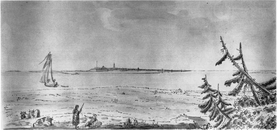
60. Unique first-state view of “Boston taken from the Harbor.” From Volume III of The Atlantic Neptune. (Text p. 128)
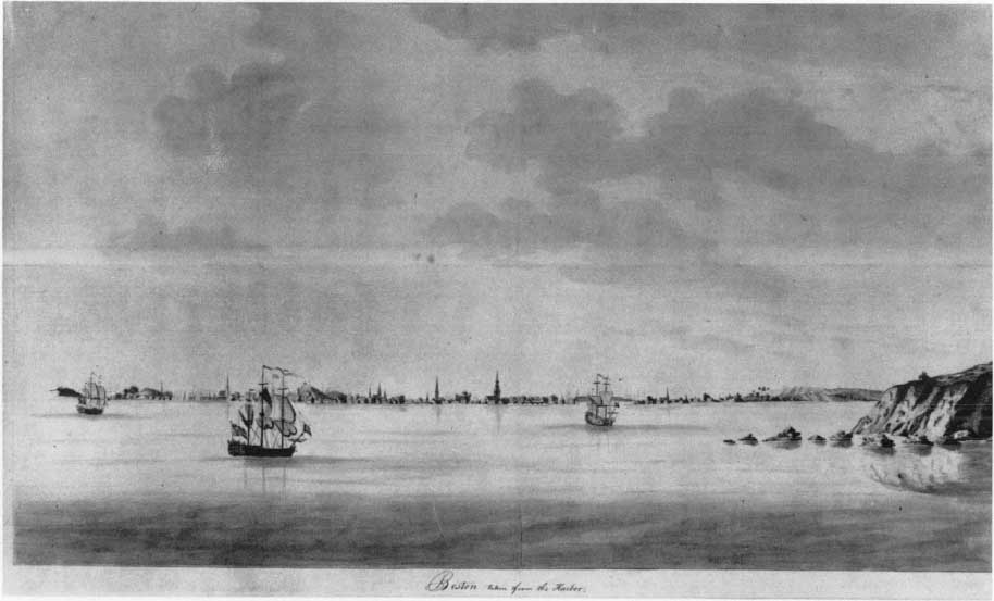
61. Third-state view of Boston. From Volume iii of The Atlantic Neptune. (Text p. 128)
62. A view of Charleston, South Carolina, late state. From Volume V of The Atlantic Neptune. (Text p. 130)
- S 70 Two Views on one sheet:
- (a) A View of Port Hood Sailing into the Harbour—18⅞″ × 9¼″
- (b) A View of the Plaister Cliffs, in George’s Bay—16″ × 12⅜″ (one state)
- S 70A A View of the Entrance of Port Hood—26¾″ × 17¾″ (one state)
- S 70B A View of the Plaister Cliffs on the West Shore of George’s Bay—15½″ × 12¼″ (one state)
- S 74 Five Views of Sable Isle on one sheet:
- (a) A View of the East End of the Isle Sable—23¼″ × 2⅞
- (b) The Eastern End of the Isle Sable—22¾″ × 4½″
- (c) A View taken from the South Side of the N.E. Barr—11⅝″ × 3⅛″
- (d) A View taken from the Ridge of the N.E. Barr—7¼″ × 3⅛″
- (e) A View of the North Shore of the Isle Sable—26⅛″ × 3½″
- S 75 Seven Views of Sable Island on two sheets:
- (a) Entrance of the Pond—West end of the Isle of Sable—30½″ × 3¾″
- (b) Wreckers Den near the Pond—12¼″ × 6⅛″
- (c) Profile view 4 leagues distant Eastern End—15″ × ¼″
- (d) Profile view 4 leagues distant of South Shore—15″ × ¼″
- (e) Profile View 4 leagues distant West Point—15″ × ¼″
- (f) North Shore (close in)—8⅛″ × 6⅛″
- (g) North Shore of Isle Sable 2 miles distant—39½″ × 4″
- S 77 A View from the Camp at the East End of the Naked Sand Hills on the South East Shore of the Isle of Sable—23¾″ × 16″
Volume III
New England
- S 89 (a) Cape Poge (Chappaquiddick)—16⅛″ × 2½″
- S 92 (a) A View of Cape Cod from the North West 20″ ×
- (b) Deer Island open with Point Shirley Sailing into Boston Harbour—22⅞″ × 12⅞″
- These views are engraved on separate plates but printed on the same sheet. The titles are in manuscript and vary in different copies, (one state)
- S 95 (a) Boston, Seen Between Castle Williams and Governors Island—20⅛″ × 4½″
- (b) Appearance of the High Lands of Agameticus—15½″ × 3¼″ (Camden Hills, Penobscot Bay Maine)
- (c) Boston Bay, The Lighthouse Bearing NW by W—18⅝″ × 2⅝″
- (d) The Entrance of Boston Harbour—29″ × 4⅝″
- S 97 A View of Boston Taken on the Road to Dorchester—25¾″ × 18⅞″ (one state)
- S 98 A View of Boston
- There are two different Views of Boston engraved on two different plates.
- The earlier view measures 31½″ × 18½″ (one state)
- The later view measures 28⅝″ × 16⅝″
- S 99 & 100 (a) Boston from Willis Creek
- (b) Long Island open on the North side of Nicks Mate Island
- (c) A View of the Country towards Dorchester taken from the Advanced Works of Boston Neck
- (d) A View of Boston from Dorchester Neck
- (e) A View of the Harbour of Boston taken from Fort Hill
- (f) A Front View of the Lines taken from the Advanced Post near Browns House.
- Each of the above views was engraved on a separate plate and each measures 8″ × 4½″. They appear in different sequences.
- S107 A View of Portsmouth Harbour
- There are three different Views of Portsmouth engraved on three entirely different plates:
- (a) A View in Portsmouth in New Hampshire taken from the East Shore—24⅛″ × 11″
- (b) No Title—24½″ × 16⅛″
- (c) Title usually “Portsmouth in New Hampshire”—22½″ × 16⅛″
- S108 (a) Castle William (in Boston Harbour)—8¼″ × 4⅝″
- (b) A View of New Castle with the Fort and Light House on the Entrance of Piscataqua River—9¾″ × 5¾″
- Engraved on two separate plates.
- S108* (Casde William in Boston Harbour)—20¼″ × 12¾″
- No tide. Described in a Ms. Table of Contents as Casde William.
- (one state)
Volume IV
- S125 A View of Quebec from the South East 21⅝″ × 11¾″
- S141 A View of Louisbourg from the North East 25⅛″ × 13⅜″
Volume V
- S146 (a) Bond Hollow bearing S by E—8¼″ × 4⅝″
- (b) Mount Pleasant halfway between the Cedars on the Hook & Light House—8⅞″ × 2½″
- Insert views on the Chart of New York Harbour.
- S148 A View of New York from the North West. 16″ × 8¼″ No engraved title, (one state)
- S150 The Phoenix and the Rose Engaged by the Enemy’s Fire Ships and Galleys on the 16th August 1776–19⅞″ × 11″
- S152 The above View has been re-engraved on the bottom half of the same plate which has been cut in two and appears alone on a separate sheet—17⅞″ × 11″ (one state)
- S153 Five Views in the vicinity of New York on one sheet:
- (a) A View of the Highlands of Neversunk—19⅜″ × 3⅞″
- (b) The South Shore of Long Island—18⅞″ × 2⅞″
- (c) New York with the entrance of the North and East Rivers—18⅝″ × 4⅜″
- (d) The Light House on Sandy Hook—8¼″ × 4⅝″
- (e) The Narrows—18⅝″ × 5½″
- S157 Three Views on one sheet of Fort Clinton & Fort Montgomery and Anthonys Nose on the Hudson River:
- (a) View of the two forts from the east—12½″ × 7½″
- (b) View of the two forts from the south—12½″ × 6⅞″
- (c) View of Anthonys Nose—13¾″ × 8½″
- Another set of these views were also engraved:
- (b) 17⅛″ × 7¼″
- (a) 15¼″ × 6¾″
- (c) 18⅝″ × 9″
- S162 A View of Charlestown—15″ × 7⅛″
- Inset on the chart of Charlestown S. C.
- S176 Two Views of Havanah on separate plates
- (a) The Harbour and part of the Town of Havanah—16½″ × 8¼″
- (b) The Entrance of Havana from within the Harbour—16½″ × 8¼″