DECEMBER MEETING, 1908
A Stated Meeting of the Society was held at No. 25 Beacon Street, Boston, on Thursday, 24 December, 1908, at three o’clock in the afternoon, the President, Henry Lefavour, LL.D., in the chair.
The Records of the Annual Meeting in November were read and approved.
The President announced the death at Newport, Rhode Island, on the ninth instant, at the age of eighty-seven, of Wolcott Gibbs, a Corresponding Member, and spoke as follows:
Professor Gibbs graduated from Columbia University in 1841, taking his master’s degree in 1844, meanwhile receiving the degree of doctor of medicine from the College of Physicians and Surgeons in 1843. After studying in Germany and France and lecturing at Delaware College, in Newark, Delaware, he became professor of Physics and Chemistry in the College of the City of New York. After a service of fourteen years in this institution, he was appointed in 1863 Rumford Professor and Lecturer on the Application of Science to the Useful Arts in Harvard College. He became Emeritus Professor in 1887. He received the doctorate of laws from Columbia University in 1873 and afterwards from four other universities.
The contributions which Professor Gibbs made to physical and chemical science were of such a character and of such importance as to give to him a world-wide reputation, and to render him one of the very foremost of American men of science, and a veritable pioneer in the realm of physical chemistry. Added to his great talent as a scientific investigator, he was a rare teacher and a much beloved friend. His closing years were spent withdrawn from the activities of the academic world, but not from the hearts and memories of those who knew him.
Mr. Ogden Codman of Lincoln, and Mr. Morris Hicky Morgan of Cambridge, were elected Resident Members; and the Hon. John Taggard Blodgett of Providence, Rhode Island, was elected a Corresponding Member.
The Rev. Henry A. Parker gave some account, which was discussed by Mr. Henry E. Woods, of the sixteen quarterings of the children of Kiniard Russell of Strensham from whom Richard Russell (1611–1676) of Charlestown, long Treasurer of the Massachusetts Bay Colony, is said to have been descended through the Russells of Hereford: but said that on examination the line of descent of the Hereford Russells from the Strensham family did not seem to have been proved: that the armorial seal used by the sons of Richard Russell seemed to show that they claimed descent from the Strensham family: but that the escutcheon on the seal—a chevron between three cross crosslets fitché within a bordure charged with (bezants?) impaling a saltire charged with a (?)—seemed to have been misinterpreted. It had been supposed to be a seal cut for Richard Russell after his marriage with his second wife, whose maiden name was Nevill, The arms, except that the bordure does not seem to have been engrailed (the tinctures not being known), resemble the arms of John Russell of Little Malvern, Worcestershire, impaling the arms of Alderford, of which family he married an heiress.464 Mr. Parker said, however, that the descent of Richard Russell from William Russell, Mayor of Hereford, seemed to be well established. From this Mr. Woods dissented, saying that the descent of Richard is not proved. On reviewing the pedigree Mr. Parker found himself obliged to agree with Mr. Woods.
Dr. James B. Ayer read some notes, covering the period from 1764 to 1785, concerning Harvard College taken during a recent visit to London from the records of the New England Company.
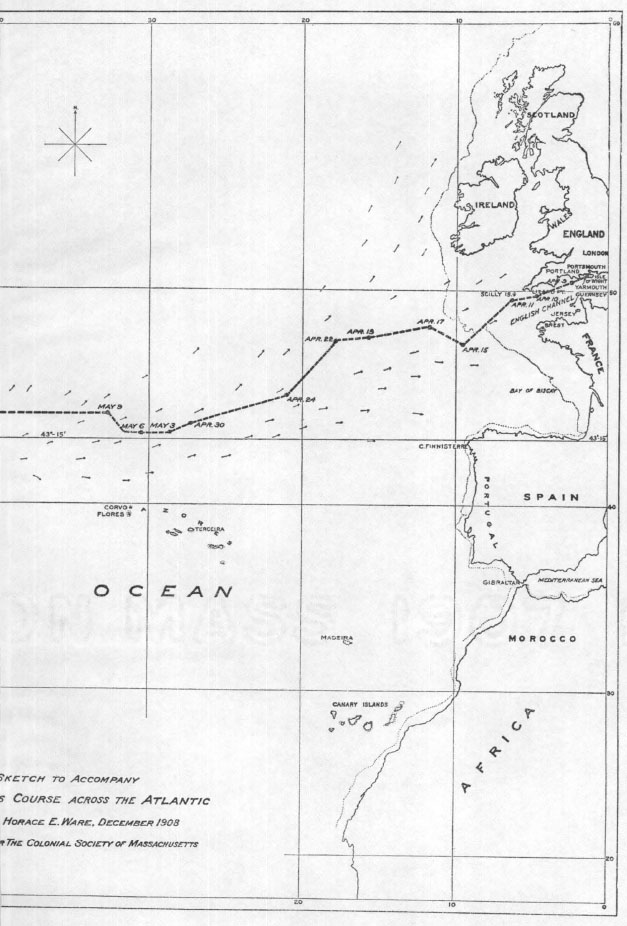
WINTHROP’S COURSE ACROSS THE ATLANTIC.
Winthrop’s fleet of four ships—namely, the Arbella, admiral; the Talbot, vice-admiral; the Ambrose, rear-admiral; and the Jewel, captain—left Yarmouth, Isle of Wight, for these shores April 8, 1630. Of these vessels the masters were, of the Arbella, Captain Peter Milborne; of the Talbot, Mr. Thomas Beecher; of the Ambrose, Captain John Lowe; of the Jewel, Mr. Nicholas Hurlston. Governor Winthrop was on board the Arbella, having in his possession the Charter of the Massachusetts Bay Company. Seven other vessels which left Southampton for the Massachusetts Bay a few weeks later are hereinafter referred to. As the voyage of Winthrop’s fleet, transferring, as it did, the Charter and government of the Colony from England to the territory of the Company in America, was of vast importance in its consequences, all the features of the voyage, including the course pursued by the ships across the ocean, must ever be of historic interest. Fortunately we have in Winthrop’s Journal465 the data whereby, though we may not be able to fix the positions of the ships from day to day, we may yet lay down in a general way the track of at least three of them for practically the entire course.
The accompanying sketch has been reduced from a plotting of the voyage made under the direction of two nautical experts upon a government chart of the North Atlantic Ocean, issued by the Hydrographic Office of the Navy Department in September, 1908. The chart and sketch are based upon Mercator’s Projection. Much of the matter on the chart not material to our subject has been eliminated, while divers descriptive words have been added to illustrate statements in the Journal.
Winthrop states that the captain of the Arbella ascertained his latitude by means of the cross-staff.466 But while the elevation of the sun above the horizon could be measured with this instrument with a fair degree of accuracy and the latitude afterwards determined, it was impossible from the lack of accurate marine time-keepers at that period to ascertain longitude at sea. It was not until the year 1761 or thereabouts that John Harrison perfected his time-keepers so as to comply with the conditions named in the Act of the British Parliament in the year 1714, providing for a reward of £20,000 to any person who should discover a method of determining the longitude to one-half of a degree of a great circle, or thirty geographical miles. Harrison had to wait until the year 1773 before receiving the balance of the reward due him.467
Winthrop therefore does not express his estimation of east or west positions or distances in degrees of longitude, but in terms of geographical places or distances, such as “about 90 leagues from Scilly, W. and by S.,” and “in the midway between the false bank and the main bank,” these east and west positions being estimated by dead reckoning, and sometimes, perhaps, by soundings.
In plotting the voyage, positions defined in the Journal both by their latitude and their bearing from geographical places have first been fixed. The line has then been run through these positions and, with one or two exceptions, through points whose latitude has been given and whose longitude has been estimated from the not too plentiful data which Winthrop has furnished as to courses and distances. The lines connecting positions are with few exceptions straight lines, there being a lack of adequate data from which to determine the length of minor courses. It is believed that the tracing of the voyage on the sketch does not vary much from the course actually pursued.
The fleet passed the Scillys before eight o’clock on the morning of April 11. Notwithstanding the courage and high purposes of both men and women, there must have been many sad regrets as the last of the Fatherland faded in the distance.
On the 15th the ships were in 47° 30′ north latitude. That night the wind grew very strong, and before midnight the Talbot was lost sight of. Every day for some days thereafter a man was sent to the top to search the horizon, but nothing more was seen of her until her arrival at Charlestown on July 2, twenty days after the Arbella had reached Salem. The three remaining ships kept on together, and on April 21 Winthrop writes, “Our captain, overnight, had invited his consorts to have dined with him this day, but it was such foul weather as they could not come aboard us.” But it is pleasing to learn that the bad weather only occasioned a postponement of this dinner, for there is the following entry under date of the 23rd: “About eleven of the clock, our captain sent his skiff and fetched aboard us the masters of the other two ships, and Mr. Pynchon, and they dined with us in the round-house, for the lady468 and gentlewomen dined in the great Cabin.”
On April 25, when in about 45° of latitude, the fleet fell in with Captain Kirke’s two ships.
In July, 1629, Quebec had been surrendered by Champlain, then in command of the French at that place, to David Kirke, commander of an expedition sent out by his father, Gervase Kirke, Sir William Alexander, and others under authority of a commission and letters of marque from Charles I. In this expedition David Kirke and his younger brothers Lewis and Thomas were each in command of one of the ships of the fleet. The writer has given a brief account of the capture of Quebec by the English, of its re-surrender to the French three years later, and of the subsequent career of the Kirkes, in the paper entitled, “An Incident in Winthrop’s Voyage to New England,” read before the Society in March, 1908.469 Therein also he gives his reasons for believing that the two ships of which Winthrop speaks were under the command of Thomas Kirke, and were carrying recruits, stores, etc., for the English garrison at Quebec.
Upon the five ships thus gathered in mid-ocean were representatives of divers of the types of men who have contributed to British expansion.
Under date of April 26, Winthrop tells us that about one o’clock Captain Lowe sent his skiff to desire the captain of the Arbella to come aboard his ship, which he did, and there met the masters of the other ships and Captain Kirke, and that before night they all returned to their ships again. This meeting of the captains on board the Ambrose must have been an occasion full of interest. Captain Kirke undoubtedly told of the stirring incidents attending the expeditions against Canada and the capture of Quebec. The chances of a renewal of the war with France must have been talked over. We can easily picture them exchanging experiences as to soundings, currents, banks, prevailing winds, courses, distances, and other like matters. They could not have failed to discuss the question of their then position at sea.
On April 29 Winthrop states that they were not come above three hundred leagues, “being about one third part of our way, viz., about forty-six north latitude, and near the meridian of the Terceras.”470 There may be some error of statement here. It appears as if Winthrop must have put his position this day too far to the north. It is not stated that this latitude was obtained by observation. On the next day, the 30th, the Journal reads that their position was in forty-four north latitude. The conditions, it would seem, did not favor the traversing so great a distance in twenty-four hours. There being these doubts, no position has been located for the 29th.
On the 30th there was a strong gale which grew into a violent storm during the night. This storm continued through May 1 and 2. The Ambrose, the Jewel, and Captain Kirke’s ships were lost sight of the first night of the storm. The Ambrose and the Jewel rejoined the Arbella, however, on May 2, but Kirke’s ships were not seen again unless in the distance on May 18.
On May 3 the ships were by observation in latitude 43½° north. This it will be noted is just about the latitude of Cape Sable. The accompanying sketch shows that during the next few days the course was west along this parallel.
The purpose of the navigators of Winthrop’s ships appears to have been to reach a position directly to the north of the Azores in the latitude in which they now were, and then to sail due west. The Azores are generally in latitude 37° to 40° north. At that time the course of vessels from a great part of western Europe to the West Indies lay more or less near the Azores, and they were perhaps a convenient point of departure for vessels bound for Virginia. Probably the islands were sometimes sought for and sighted merely to make sure of a vessel’s position at sea, especially in going west. Some of the officers of Winthrop’s fleet had doubtless many times sailed to them, or by and in sight of them. This experience must have invested them with considerable skill not only in finding the islands themselves, but also in reaching positions in their neighborhood from which to take departures.471
By May 9 the course of the ships had brought them further north and they were in latitude 44½°, while their longitude was supposed to be a little west of Corvo, the island which with Flores makes the northwesterly group of the Azores. On May 14 they were still in latitude 44½°, having made some progress, though they had encountered heavy weather.
On the 17th the Journal says they sounded and found no ground at one hundred fathom and more.
On the 18th towards night, while the rear-admiral was to leeward of them, they saw some two leagues more to leeward two ships which they conceived were Captain Kirke’s. From this it would appear that Kirke was sailing for the time being on a parallel not very far to the north of 43½°.
On May 19 Winthrop states that they were in 44° 12′ north, “and by our account in the midway between the false bank and the main bank.” The “main bank” is the Great or Grand Bank of Newfoundland. I have succeeded in identifying the “false bank” as the bank now called the Flemish Cap. This bank has been, and perhaps sometimes now is, also called the Outer Bank. It lies about 120 miles eastward of the northeast part of the Grand Bank.472
The origin of the name “False Bank” is not, it would seem, far to seek. In the time of the early voyages to the banks and coasts of Newfoundland, fishermen and other mariners, not knowing their longitude, must sometimes, finding ground here, have mistaken this bank for the Great Bank. Discovering their error later, they got to bestowing this uncomplimentary name upon the innocent object of their misapprehension. As stated above, no ground was found on the 17th. Perhaps the captain was then sounding for the False Bank. It does not extend so far south as their then position; but its limits were probably not definitely known at that time. It may be, however, that they wanted to verify their latitude and make sure that they were not so far north as the False Bank; and that when Winthrop states that on the 19th they were midway between the False Bank and the Main Bank, he meant on the meridian which runs between those banks.
This is the entire entry under May 31:
Wind N. W. a small gale, close and cold weather. We sounded, but had no ground. About noon the wind came N. by E., a stiff, constant gale and fair weather, so as our ship’s way was seven, eight, and sometimes twelve leagues a watch. This day, about five at night, we expected the eclipse, but there was not any, the sun being fair and clear from three till it set.
I estimate that they were in about latitude 42° 30′ and longitude 61° 25′ when they expected the eclipse.
Robert W. Willson, Professor of Astronomy in Harvard University, has kindly furnished me with the following data regarding this eclipse, having computed time of day and duration as a partial eclipse at the position assumed above. The eclipse in question was a total solar eclipse, and is number 6732 of Oppolzer’s Canon der Finsternisse, Vienna, 1887. The path of totality began at sunrise in the mid-Pacific, was over Hudson’s Bay at local noon, thence traversed Greenland, Ireland, Land’s End, and the British Channel, passed through France, and ended near Marseilles at sunset. In latitude 42° 30′, longitude 61° 25′, the eclipse began at 1 h. 55 min. P.M. local mean time, and ended at 3 h. 8 min. p. M. The maximum phase was at 2 h. 32 min. when the sun was still giving about 70 per cent of his whole light; at 3 P.M. he was giving about 92 per cent, and the eclipse was practically over. At maximum phase the diminution would not have been noticeable unless one were looking for the eclipse at the time. We are, of course, not sure that Winthrop’s time was within several minutes of correct local mean time. The language quoted may imply that the sun was more or less clouded before three, and that they were not looking for the eclipse before five. Winthrop or some of his associates had undoubtedly seen predicted the time the eclipse would take place in Great Britain and Ireland. Their failure to see it was on account of the sun’s being obscured before three, or because they failed to make sufficient allowance for the difference in local time between England and their position plus the difference in absolute time of the occurrence of the eclipse in the two regions.
On June 2 the captain of the Arbella, knowing that there were dangerous shoals to the south, fitted on a new mainsail that was very strong and double, not liking to adventure with his old sails as before, when he had sea-room enough. The shoals referred to must have been the Georges.
On June 3 there was thick fog. About two p. M. ground was found at about eighty fathoms,—a fine gray sand. They tacked and stood S. S. E. and shot off a piece of ordnance to notify the consorts, who had not been seen since the previous evening. As there is no further mention of the Ambrose and the Jewel until after their arrival in port, those vessels probably remained separated from the Arbella after June 2.
On June 6 the wind was northeast and later north, a good gale, but still foggy at times. The Journal goes on, “We stood W. N. W., both to make Cape Sable, if we might, and also because of the current, which near the west shore sets to the S., that we might be more clear from the southern shoals, viz., of Cape Cod.”
At this time navigators evidently knew of the Arctic current setting to the south and southwest off the coasts of Newfoundland and Nova Scotia. The general directions of this and of the Gulf Stream current to the south and east of it, the Gulf Stream current flowing northeasterly, are shown on the sketch. The ships had to contend against the Gulf Stream current until about May 14. Thereafter the Arctic current helped them south and west to Cape Sable. The following is the rest of the entry for the same day, June 6:
About two in the afternoon we sounded and had ground at about eighty fathom, and the mist then breaking up, we saw the shore to the N. about five or six leagues off, and were (as we supposed) to the S. W. of Cape Sable, and in forty three and a quarter. Towards night it calmed and was foggy again, and the wind came S. and by E. We tacked and stood W. and by N., intending to make land at Aquamenticus, being to the N. of the Isles of Shoals.
The land they saw was undoubtedly Cape Sable or other land on the south shore of Nova Scotia. The first paragraph quoted under June 6 indicates their desire to see land, the object being to learn their position, especially as regards longitude. They had had no means of estimating this since they had left the Scillys some eight weeks before except by dead reckoning, soundings, and possibly at some positions by noting the variations of the compass.473 If they could have ascertained longitude as it is ascertained, now, they could have sailed on a great circle from the Scillys to or near to Cape Sable, and this would have been a great saving in time and distance, while their knowledge of their exact positions would have minimized the danger of shipwreck on the coast.
As illustrating the difficulties under which navigators labored before they had the means of finding their longitude, I would cite two instances which occurred during Commodore George Anson’s voyage around the world, 1740 to 1744, more than a hundred years after Winthrop’s voyage. Captain Legge, in command of the Severn, after doubling Cape Horn, steered, as he thought, for the island of Chiloe, but, to his astonishment, found himself on the wrong side of South America, having the high land of Patagonia to the westward of him, and being twelve degrees out of his longitude.474
Commodore Anson himself, in command of the Centurion, gained the west coast of South America, but a great number of his men were afflicted with scurvy. To recruit them by life on shore and with vegetable food he determined to steer for the island of Juan Fernandez. It was resolved, if possible, “to hit the island on a meridian.” But when they had reached its latitude no island was in sight. Upon consultation of the officers it was the consensus of opinion that they were west of the island, and it was decided to sail east on its parallel. The result was that in two days they made the mountains of Chili. Nothing remained but to reverse their course; but their progress west was much slower than it had been east, and it took some eleven days to reach Juan Fernandez. In consequence of this error of judgment it was estimated that from seventy to eighty men were lost, who might have been saved if the course of the ship had been originally directed west.475
It will be observed that the next landfall intended was at Agamenticus, now York, Maine. A settlement had been made at Agamenticus in or about the year 1623, on land included in a patent issued by the Council for New England to Sir Ferdinando Gorges of 24,000 acres on both sides of the Agamenticus (York) River.476 It lies in latitude between 43° 5′ and 43° 10′. The elevation now called Mt. Agamenticus lies in the north part of York and in latitude between 43° 10′ and 43° 15′. It was therefore clearly their intention to continue west on practically the same parallel on which they were until they should see land, and then to keep on along the coast to Salem.
It would appear, however, that wind and weather did not serve this purpose, for between head winds and calms they were on the afternoon of the 8th brought to within sight of Mt. Desert, then about ten leagues to the northwest of them. Their general course was now along the coast. On the 10th they lost sight of “the former land,” which I assume to have been the high lands from Mt. Desert to the Camden Hills, and made other high land on their starboard as far off as they could descry,477 but lost it again.
I make this extract from a further entry under the 10th:
About four in the afternoon we made land on our starboard bow, called the Three Turks’ Heads, being a ridge of three hills upon the main, whereof the southmost is the greatest. It lies near Aquamenticus. We descried, also, another hill, more northward, which lies by Cape Porpus. We saw, also, ahead of us, some four leagues from shore, a small rock, called Boone Isle, not above a flight shot over, which hath a dangerous shoal to the E. and by S. of it, some two leagues in length. We kept our luff and weathered it, and left it on our starboard about two miles off. Towards night we might see the trees in all places very plainly, and a small hill to the southward of the Turks’ Heads. All the rest of the land to the S. was plain, low land.
Then, in order to have plenty of leeway to pass the ledge of rocks near Boone Isle, they tacked and stood S. E. with a stiff gale at S. by W.
The question arises, to what elevation of land does Winthrop refer when he speaks of the “Three Turks’ Heads.” In search of an answer I will cite certain features of Mt. Agamenticus as laid down on map “Maine—New Hampshire—York Sheet” of the United States Geological Survey, “Edition of Oct. 1893 reprinted Mar. 1904.” This shows three peaks or hills on a ridge, the height of the most northeasterly peak being 513 feet, that of the central 504 feet, and that of the southwesterly (and “southmost”) 675 feet. The northeasterly peak is about seven-tenths of a mile from the central peak, and the latter is about the same distance from the southwesterly peak. Some two and one-half miles to the south of the southwesterly peak is a hill or peak 348 feet in height. South of this on the map there are no elevations above 169 feet, and the conditions, in my opinion, accord with Winthrop’s statement that “all the rest of the land to the S. was plain, low land.” On the map the name “Mt. Agamenticus” is written on the southwesterly of the three peaks. The characteristics of Mt. Agamenticus above recited conform to those of the Three Turks’ Heads as described by Winthrop, and I know of no other prominent elevations having those features. My conclusion is that when Winthrop mentions “Agamenticus” or “Aquamenticus” he means the Gorges settlement at what is now York; and that by the “Three Turks’ Heads” he means the hill now called Mt. Agamenticus together with its two companion hills as above.478
On June 11 the wind was still southwest, and they stood to and again all day within sight of Cape Ann. On the next day the Arbella arrived at Salem, passing through the narrow strait between Baker’s Island and Little Island and coming to anchor a little within the islands. On the 13th the Jewel arrived—also at Salem. The Ambrose reached the same place June 18. On July 2 the Talbot arrived at Charlestown as before stated. Her voyage had lasted nearly three months, during which she had lost fourteen passengers.
Besides the historic importance of Winthrop’s voyage considered by itself, it seems to me that it must have been more or less typical of many of the voyages from England to Massachusetts in the seventeenth century. In such case, by carefully studying that voyage we may be learning considerable about other voyages also. This view would particularly apply to the paths taken by the ships over the ocean. On inspecting the accompanying sketch it will appear that a vessel from Britain sailing southwesterly until it struck the parallel of, say, 43° 15′, might well run down that parallel, get soundings on the southerly end of the Great Bank of Newfoundland and on the banks off Nova Scotia, keep away from Georges Shoal, obtain sight of land at Cape Sable and ascertain position, and thence run down the same parallel until Mt. Agamenticus was sighted.479 This landmark is unique, and there are no other high hills or mountains in the neighborhood. Seeing it at a distance out at sea, the navigator would know his position and could at once shape his course for Massachusetts Bay. The above, like any other intended course at sea, is to be sailed subject to conditions of wind and weather. If after passing Cape Sable the wind was adverse for a considerable time, for the purpose of determining position the coast of Maine to the north might be sought with comparative safety because of their having the means of ascertaining their latitude. Such may have been the reason for the Arbella’s coming within sight of the Maine coast. After Agamenticus had been sighted, there would seem to have been no necessity for making a tack inside Boone Island. The purpose of so doing was probably to obtain information as to the lay of the land and the general conditions of the region; perhaps to study Mt. Agamenticus as a landmark. In this way the men on the Arbella doubtless acquired a knowledge of those parts which it would not have been practicable for so many to have attempted to do after they had become located in the Bay. But whatever the tracks of other ships bringing passengers across the Atlantic at that period, or whatever their build or characteristics, they appear to have been in the hands of skilful navigators.480
There were seven other ships destined for the Massachusetts Bay which it was intended should be of Winthrop’s fleet, but not being ready for the voyage they remained for the time at Southhampton. They sailed, however, in May and all arrived here early in July.481
Thus there were eleven ships in this particular expedition, though sailing in two separate fleets or divisions, for we may assume, I think, that the seven ships sailed from Southampton together as they all arrived at Charlestown or Salem between July 1st and July 6th, inclusive.482 Not only were some seven hundred men, women, and children transported in these eleven vessels, but, as before stated, the Charter and government of the Colony were transferred to Massachusetts. An English commercial and colonial company had become an American Commonwealth. In the accomplishment of this great purpose one cannot fail to see the exercise of wisdom, of courage, of business ability, and of the power of organization, all in a high degree.
1 The title of this book is as follows:
The | Constitutions | of the | Free-Masons, | Containing the | History, Charges, Regulations, &c. | of that most Ancient and Right | Worshipful Fraternity. | For the Use of the Lodges. | London Printed; Anno 5723. | Re-printed in Philadelphia by special Order, for the Use | of the Brethren in North-America. | In the Year of Masonry 5734, Anno Domini 1734. | Reproduced in Facsimile by the R. W. Grand Lodge of Pennsylvania. | In the Year of Masonry 5906; Anno Domini 1906.
2 This paper was originally prepared to be read as a part of the memorial exercises at Cambridge which were held under the auspices of the Harvard Memorial Society, in honor of the three hundredth anniversary of Harvard’s birth. The material then collated relative to the construction of houses, etc., when worked into shape proved to be far in excess of the demands for the occasion, so that the paper had to be much abridged in reading; but in submitting it to the Colonial Society with a view to publication, the rejected matter has been restored.
3 Winthrop’s Journal, ii. 88, note by Savage.
4 Ibid. ii. 342.
5 Magnalia (1853), ii. 10.
6 Cotton Mather gives his father’s argument in full, as to the power of the College to confer degrees, in Magnalia, ii. 19, 20, and the degree itself, ii. 26.
7 Magnalia, ii. 10, 30.
8 Boston Record Commissioners’ Reports, vol. iii. p. iv.
9 Massachusetts Colony Records, i. 196.
10 Winthrop’s Journal, i. 237.
11 In “The Site of the First College Building at Cambridge,” in the Proceedings of the American Antiquarian Society for October, 1888, the “Way to Charlestown” is identified with Kirkland Street, and the inference is drawn that the town grant was north of Kirkland Street, as it is now laid out. There can be but little doubt that Kirkland Street represents the “Way to Charlestown,” but whether the way was not from time to time removed from place to place is another question. President Wadsworth’s location of the town grant within the Yard shows his opinion, and my own later views are expressed in “The College in Early Days,” in the Harvard Graduates’ Magazine for April, 1893.
12 Massachusetts Colony Records, i. 206.
13 Records of the First Church in Charlestown, Boston, 1880, p. 9.
14 “The 26 of the ii. Month” (Boston Record Commissioners’ Reports, vol. iii. p. iv.).
15 Records of the First Church in Charlestown, p. 165.
16 Frothingham’s History of Charlestown, p. 74.
17 In Pientissimum, Reverendissimumque virum, Johannem Harvardum, è suggestio Sacro Caroloensi ad cœlos evectum (Magnalia, ii. 33).
18 Frothingham’s History of Charlestown, p. 55.
19 Frothingham further says that in another division his lot was nearly a third larger than that of Mr. Symmes, and adds that on November 27, 1637, he had a grant of three and a half feet of ground for a portal (History of Charlestown, p. 74).
20 Boston Record Commissioners’ Reports, vol. iii. p. iv.
21 Diary, i. 446, 447.
22 Quincy’s History of Harvard University, i. 48, facsimile of the record.
23 Hutchinson’s Collection of Original Papers, p. 49.
24 Massachusetts Colony Records, i. 408; Palfrey’s History of New England, i. 298; Neal’s History of New England, i. 129, 130.
25 Hutchinson’s History of Massachusetts (1795), i. 431.
26 Journal, i. 33.
27 Winthrop, writing in 1633 of the proceedings against Saltonstall, Humphry, and Cradock, says that “the defendants were dismissed with a favorable order for their encouragement, being assured by some of the Council, that his Majesty did not intend to impose the ceremonies of the Church of England upon us; for that it was considered that it was the freedom from such things that made people come over to us” (Journal, i. 103).
28 His description in his mother’s will as “clarke” and in his marriage licence as “clìcum,” carries with it the probability that he was ordained in the Anglican Church.
29 Winthrop’s Journal, i. 219, 220.
30 Ibid. i. 220. The proceedings this day were replete with interest. Winthrop baffled Vane’s attempt at delay and finally compelled him against his will to proceed with the election by threatening to assume charge of the meeting himself, if Vane would not yield to the desires of the majority.
31 Winthrop’s Journal, i. 220.
32 Ibid. i. 220.
33 Ibid. i. 232.
34 Hutchinson’s History of Massachusetts, i. 64. Winthrop’s account is: “None of them met him & the Sergeants who had escorted the former Governor refused to perform that service for him alleging that such service had been performed on account of the man not the place” (Journal, i. 234).
35 Hutchinson’s History of Massachusetts, i. 65.
36 Winthrop’s Journal, i. 235.
37 Wonder-working Providence (1867), p. 72.
38 Massachusetts Colony Records, i. 74.
39 Ibid. i. 74, 76, 77, 79, 91, 109, 160 (wages); 126, 183 (sumptuary laws).
40 Massachusetts Colony Records, i. 88. Thomas Dexter was in March, 1632–33, set in the bilboes, disfranchised and fined 40 s. for reproachful and seditious words against the Government here established, and for finding fault to divers with the Acts of the Court, and for saying “this captious  t will bring all to naught, adding that the best of them was but an atturney” (ibid. i. 103).
Capt. John Stone, in September, 1633, for “confronting aucthority, abuseing Mr Ludlowe both in words and behaviur, assalting him & calling him a iust as,” was fined £100 and prohibited “comeing into this pattent, wthout leaue of the  , vnder the penalty of death” (ibid. i. 108).
41 Massachusetts Colony Records, i. 211, 212.
42 Journal, i. 322, 323.
43 Boston Record Commissioners’ Reports, ii. (second edition) 1.
44 Massachusetts Colony Records, i. 86.
45 Ibid. i. 75.
46 Ibid. i. 83.
47 Ibid. i. 111.
48 Ibid. i. 93.
49 The situation was sized up by Chalmers in the following words:
The colonists became at length dissatisfied with adjudications various and contrary, since every magistrate decided according to the equity of his own mind, without established laws to inform his judgment, or former precedents to direct his practice. Dissatisfaction soon swelled into clamor, and continued complaint produced ultimate reformation (Introduction to the History of the Revolt of the American Colonies, Boston, 1845, i. 50).
50 Winthrop himself contended that he was not in favor of a rigorous execution of the orders against those who were merely residents. He stated “that it was his judgment, that, in the infancy of the plantations, justice should be administered with more lenity than in a settled state;” and after some discussion he acknowledged “that he was convinced, that he had failed in over much lenity and remissness and would endeavor (by God’s assistance), to take a more strict course hereafter” (Journal, i. 178).
51 Magnalia, ii. 33.
52 Autobiography, p. 64.
53 Wonder-working Providence, p. 103.
54 Certain Select Cases Resolved, p. 49.
55 The memorandum made by Winthrop and published by Savage in the Addenda reads: “Mr. Harvard gave to the College about £800” (Winthrop’s Journal, ii. 342). The author of New England’s First Fruits, p. 12, says “one halfe of his estate, (being in all £1700) towards the erecting of a college, and all his Library.” Thomas Shepard says, “The Lord put it into the heart of one Mr. Harvard, who dyed worth £1600 to give halfe his estate to the erecting of the Schoole” (Autobiography, p. 64). Johnson in his Wonder-working Providence fixes the amount of the bequest at “near a thousand pounds” (p. 133).
56 Young’s Chronicles of Massachusetts, p. 374.
57 Hutchinson’s History of Massachusetts, i. 91; Johnson’s Wonder-working Providence, p. 31.
58 Magnalia, i. 80.
59 Winthrop’s Journal, i. 268.
60 Massachusetts Colony Records, i. 192.
61 Ibid. i. 201.
62 Winthrop calls them wigwams (Journal, i. 36, 38); Prince, booths and tents (Annals, p. 309); Scottow, huts and smoky cottages (Narrative of the Planting of Massachusetts Colony, 1694, p. 16); Hubbard, small cottages (History of New England, p. 134); Winslow, booths and huts (Good News from New England, 1648, 4 Massachusetts Historical Collections, i. 201)
63 Early Records of Charlestown, in Young’s Chronicles of Massachusetts, p. 374.
64 March 2, 1646–47, John Crocker vs. Thomas Shawe, “for coming into his house by pulling aside some loose pallisadoes, on ye Lords day, about ye middle of ye day” (Plymouth Colony Records, i. 111).
65 New Englands Plantation, in Young’s Chronicles of Massachusetts, p. 244.
66 Winthrop’s Journal, i. 48.
67 For references to wooden chimneys and thatched roofs, see Dudley’s letter to the Countess of Lincoln, March, 1631 (Collections New Hampshire Historical Society, iv. 248)
68 Boston Record Commissioners’ Reports, ii. 70.
69 Winthrop’s Journal, i. 54.
70 Magnalia, i. 311.
71 Winthrop’s Journal, i. 63.
72 Mourt’s Relation (1865), p. 9.
73 Scottow’s Narrative of the planting of the Colony, p. 40.
74 Boston Record Commissioners’ Reports, ii. 40.
75 Ibid. iv. 63. See also two charges in 1637 for daubing the meeting-house (Essex Institute Historical Collections, iv; Second series, i). Roger Clap describes the Castle as built with “Mud walls which stood for divers years” (Memoirs, Boston, 1731, p. 15).
76 Winthrop’s Journal, i. 82.
77 Ibid. i. 73.
78 Scottow’s Narrative of the Planting of Massachusetts Colony, p. 41.
79 Winthrop’s Journal, i. 87.
80 The Early College Buildings at Cambridge, Proceedings of the American Antiquarian Society for April, 1890.
81 It may seem unnecessary to devote so much time to the discussion of daubed walls in connection with the career of one whose mother was from Stratford and a contemporary of the poet who wrote the familiar lines—
Imperious Cæsar dead and turned to clay
Might stop a hole to keep the wind away.
82 “Bring paper and linseed oil for your windows” (Winslow in Mourt’s Relation, p. 142).
83 Young’s Chronicles of Massachusetts, p. 254. Capt. Smith says, “traine oyle with the splinters of the roots of pine trees for candles” (3 Massachusetts Historical Collections, iii. 38); Wood, New England’s Prospect (1898), p. 18.
84 Massachusetts Colony Records, i. 92 (corn), 97 (bullets), 140 (beaver), 208 (wampum).
85 Dunster’s list of these books comprehends 260 titles. Several of these titles indicated works published in several volumes. See A few Notes concerning the Records of Harvard College, Bibliographical Contributions, Library of Harvard University, No. 27. Quite recently a praiseworthy effort has been put forth to place upon the shelves of the Harvard Library a copy of each work named in the catalogue—a contemporaneous publication by preference. The study of the subject has revealed the fact that the library bequeathed by Harvard must have contained 373 volumes.
86 The effort to duplicate these volumes has disclosed the fact that many of them were octavos and some even smaller.
87 Winthrop’s Journal, i. 304.
88 Winthrop was not, apparently, opposed to its use. March 18, 1627, he wrote “We want a little tobacco. I had very good, for seven shillings a pound at a grocer’s by Holborn Bridge” (Journal, i. 350). The statutes referred to will be found in the Massachusetts Colony Records, i. 101 (use prohibited), 109 (constables to take note of persons), 136 (sale prohibited), 204, 206 (former laws repealed), 241–242 (new law against use).
89 Winthrop’s Journal, i. 377.
90 Ibid. i. 379.
91 Wood writes in 1634: “Four eggs may be had for a penny and a quart of milk at the same rate and when butter is six pence a pound and Cheshire cheese at five penc” (Young’s Chronicles of Massachusetts, p. 414).
92 When the Governor’s wife arrived in 1631 people sent him “fat hogs, kids, venison, poultry, geese, partridges, &c.” (Journal, i. 57). By 1633, the gardens had become productive, so that notwithstanding a scarcity of corn people lived well with fish and the fruit of their gardens (ibid. i. 108).
93 “For bread and beer, that it was denied to them betwixt meals, truly, I do not remember, that ever I did deny it unto them; and John Wilson will affirme, that, generally, bread and beer was free for the boarders to go unto” (Winthrop’s Journal, i. 310 note).
94 Thomas Dudley writes in 1631 to the Countess of Lincoln saying “having yet no table, nor other room to write in than by the fireside upon my knee” (Young’s Chronicles of Massachusetts, p. 305).
95 My attention has been called to the omission in the text of reference to the use of intoxicating liquors. Of course drunkenness was one of the troubles of that time. Numerous convictions are recorded for the offence, but at the period which I cover, all liquors were imported except strong beer. In 1630, Winthrop restrained the drinking of healths at his table, and so it grew little by little to disuse (Journal, i. 37). In 1635, he speaks of drunkenness occasioned by people running to the ships (ibid. i. 161).
96 I am indebted to Professor Kittredge for calling my attention to two things: first, the proverb “fingers were made before forks,” evidence in itself that the knife was not used by well bred persons for conveying food to the mouth; and secondly, to Chaucer’s description of the dainty manner in which the Prioress fed herself, obviously with her fingers, given in the Prologue to the Canterbury Tales. Thomas Shepard in one of his sermons calls attention to the danger accompanying the use of the knife in cutting one’s meat: “Its from the excellency of a knife to cut well, but to cut my finger with it when I should be cutting of my meat with it, ariseth not from the end of the knife, nor from the intention of him who made it” (Certain Select Cases Resolved, p. 7).
97 Montaigne’s Journal, iv. 210.
98 William T. Davis in his Ancient Landmarks of Plymouth (p. vii.) makes substantially the same observations as to the preponderance of napkins.
99 Massachusetts Colony Records, i. 210.
100 Young’s Chronicles of Massachusetts, p. 54.
101 “We could not follow them in our Armor” (Winthrop’ Journal, i. 199).
102 Massachusetts Colony Records, i, 125.
103 “Our men being completely armed with Corslets, muskets, bandoliers, rests and Swords.” Head pieces are also mentioned in this account. (Capt. John Underbill’s Newes from America, in Hart’s American History told by Contemporaries, p. 439.) Besides the expression, showing that the men were in armor—quoted in the note above—Winthrop, in another description in the same year, 1636, speaks of their being armed with corselets (Journal, i. 194).
104 Massachusetts Colony Records, i. 126, 183.
105 Boston Record Commissioners’ Reports, ii. 8, iv. 3.
106 Boston Record Commissioners Reports, iv. 22.
107 “He demands of the next man he met, what the signall of the drum ment, the reply was made they have as yet no Bell to call men to meeting” (Johnson’s Wonder-working Providence, p. 103).
108 Winthrop’ Journal, ii. 220.
109 Wonder-working Providence, p. 41.
110 See C. F. Adams’ Antinomianism (Prince Society), p. 251. Shepard did not take a very active part in the discussion relative to the heresy of Mrs. Hutchinson, and he evidently considered that he occupied a neutral opinion in the controversy, for he says that Newtown was “kept spotless from the contagion of opinion.” He was, however, one of a committee which examined Mrs. Hutchinson, and although he was not violent in his opposition to her, yet he joined in a report with Thomas Welde which was referred to several times in the discussion. It seems to me therefore that he must be considered as practically taking sides in the matter.
111 Cotton Mather is authority for the statement that the Clergy had “eminent skill in physick.” He says, “it is well known that until two hundred years ago, physick in England was no profession distinct from divinity.” Most of Charles Chauncy’s sons, six in all, were, he says, practicers of physic as well as clergymen (Magnalia, i. 475).
112 Magnalia, ii. 33.
113 It is known that Mrs. Harvard bore children by her second husband. It is probable that Wilson was thinking of these children when he composed his elegy. The form of the elegy, an address by Harvard to an assembly of graduates, involves the idea of the lapse of many years after Harvard’s death before such a gathering could have taken place. Wilson died in 1667 at the age of seventy-nine, and if we allow an interval of at least twenty-five years to have elapsed after Harvard’s death before the elegy was composed, it would make him seventy-five years of age when it was written. This may perhaps account for this expression in the elegy, as confusion of memory on his part. That this must have been so, becomes apparent when we take into consideration the date of Harvard’s marriage, April 19, 1636.
114 Massachusetts Colony Records, i. 183.
115 Ibid. i. 208.
116 Ibid. i. 217.
117 The close resemblance of this committee to the body to whom was entrusted the care and regulation of the affairs of the College in 1642, has led encyclopædists to record that members of the committee were at that time appointed Overseers of Harvard College.
118 Magnalia, i. 386.
119 Autobiography, p. 64.
120 5 Massachusetts Historical Collections, v. 447, note. George E. Ellis was one of the committee in charge of the publication of this volume and doubtless is responsible for this witty and appropriate quotation.
121 The assumption that Harvard’s will was nuncupative may be correct, but it does not rest upon direct evidence.
122 Publications, viii. 243, 244.
123 The Boston News-Letter of Thursday, 30 September, 1756, stated that “On Saturday last His Excellency embarked on board His Majesty’s Ship Mermaid, Washington Shirley, Esq; Commander” (p. 1/2).
124 Suffolk Deeds, ci. 164.
125 Suffolk Probate Files, no. 15,041.
126 Suffolk Deeds, cxxxv. 196. See also clxx. 48, 96, clxxvi. 13, 15.
127 Born in 1590 at Wethersfield, Essex, where his father the Rev. Richard Rogers held a lectureship from about 1577 to 1618, being repeatedly “suspended for Nonconformity though supported by the Puritan Lord Knolys.” Ezekiel Rogers’s elder brother, Daniel, succeeded his father, after an interval, in the Wethersfield lectureship. All three were of the University of Cambridge. See Victoria History of the County of Essex, ii. 52.
128 The History of Rowley, by Thomas Gage, with an Address by the Rev. James Bradford, 1840. Most of the information about Mr. Rogers is contained in the Address and in Appendix A to the Address.
129 This reminds one of the inability of the younger Weller to see his father in court.
130 Calendar of State Papers, Domestic, 1638–1639, pp. 430, 431.
131 Calendar of State Papers, Colonial, 1574–1660, pp. 263, 264.
132 Royal Commission on Historical Manuscripts, Report vii. App. p. 538.
133 There is a letter dated November 6, 1621, from Mr. Rogers to Lady Joan Barrington, the wife of Sir Francis, who was a daughter of Sir Henry Cromwell and so an aunt of the Protector (ibid. p. 543). Another letter dated September 28, 1626, tells of Mr. Rogers’s sickness and recovery (ibid. p. 543). In 1644 Sir Thomas Barrington died and was succeeded by his son Sir John, and Mr. Rogers wrote to Mr. John Kendall at Sir John Barrington’s on December 8 of that year—
A long letter about what the late Sir Thomas Barrington had promised him in the way of preferment. He alludes to his diligent attendance on and comfort to Sir Thomas “on his sad and deep distemper of melancholy; not only in the day but in the night watchings and midnight rising he (Rogers) did much to impare his health.” (On the back is the copy of an answer by Kendall dated 1 May, 1645, in which he says that Sir Thomas had left his son burdened with 10000 l) (ibid. p. 570).
Mr. Rogers wrote again November 9, 1645, and once more December 9, 1646: “He mentions that old Lady B. promised him 100 l, and that Mr. Bridge said that he himself paid it to Robert Barrington, to be sent to New England for Rogers.” On April 25, 1646, “John Barrington to Ezekiel Rogers in England.—Copy of a letter on the subject of Rogers’s claims.” Was he then in England? See also a letter of the Rev. Daniel Rogers, a brother of Ezekiel, of July 7, 1647 (ibid. p. 570).
134 Ibid. pp. 543, 570.
135 Barton Stacey, a tithing and parish in Hants. The parish includes also the townships of Bransbury, Drayton, and Newton Stacey.
136 Calendar of State Papers, Domestic, 1635, pp. 520, 521.
137 Magnalia (1820), i. 74.
138 Bond, Genealogies and History of Watertown, p. 995.
139 Massachusetts Colony Records, i. 170.
140 Trumbull, History of Connecticut, i. 11.
141 Johnson, Wonder-working Providence, pp. 75, 77; Holmes, History of Cambridge, 1 Massachusetts Historical Collections, vii. 15, 16; Contributions to the Ecclesiastical History of Connecticut, p. 86 note.
142 Winthrop’s Journal (1853), i. 214 note.
143 1 Massachusetts Historical Collections, ix. 154; Contributions to the Ecclesiastical History of Connecticut, p. 512; Stiles, History of Ancient Wethersfield, i. 24. But see Records of the First Church of Dorchester, Massachusetts, 1636–1734, p. vii. The records of the Windsor Church, now extant, do not embrace anything pertaining to its life at Dorchester, Massachusetts.
144 Colonial Records of Connecticut, i. 2.
145 Journal, i. 203.
146 New England Historical and Genealogical Register, xxxv. 21
147 Massachusetts Colony Records, i. 26, 103, 123.
148 New England Historical and Genealogical Register, iv. 230.
149 4 Massachusetts Historical Collections, vi. 580.
150 New England Historical and Genealogical Register, xlviii. 263.
151 Stiles, History of Ancient Windsor, i. 429.
152 Magnalia, i. 74.
153 Colonial Records of Connecticut, i. 7.
154 Holland, History of Western Massachusetts, i. 24.
155 New England Historical and Genealogical Register, xxxv. 21. Dr. H. R. Stiles, in his History of Ancient Windsor, i. 54, and of Ancient Wethersfield, i. 39, seems to confuse him with the Rev. Henry Smith, who later came over from England and became the minister in Wethersfield. See his Ancient Wethersfield, i. 154.
156 Hazard, Historical Collections, ii. 113.
157 Hazard, Historical Collections, ii. 118.
158 Trumbull says that this reads “inconvenient” in the manuscript Journals of the Congress (Historical Notes on the Constitutions of Connecticut, p. 5).
159 Hazard, Historical Collections, ii. 119.
160 Trumbull, History of Connecticut, i. 525.
161 Bowen, Boundary Disputes of Connecticut, 15.
162 Trumbull, History of Connecticut, i. 544.
163 Winthrop’s Journal, i. 477.
164 Massachusetts Colony Records, i. 160.
165 Dr. Henry Bronson states, I think mistakenly, that Mr. Welles was for a short time a magistrate under the Massachusetts commission. New Haven Colony Historical Society Papers, iii. 296.
166 Colonial Records of Connecticut, i. 12.
167 Collections of the Connecticut Historical Society, i. 13.
168 Burt, First Century of the History of Springfield, i. 152.
169 As late as 1639 there were probably not over fifteen men there. Green, Springfield, 1636–1886, p. 45.
170 Dwight’s Travels in New-England and New-York, i. 319.
171 New England Historical and Genealogical Register, v. 472.
172 2 Massachusetts Historical Collections, vi. 308.
173 Young’s Chronicles of Massachusetts, ii. 283.
174 Morris, Early History of Springfield, p. 11; Todd (The Burr Family) puts the date of his removal as 1644. He represented Fairfield in the Connecticut General Court in 1645, his name being enrolled as “Jehu Burre” (Colonial Records of Connecticut, i. 130).
175 Colonial Records of Connecticut, i. 10, 13.
176 Letter quoted in Taylor, Roger Ludlow, p. 70.
177 Massachusetts Colony Records, i. 192.
178 Winthrop’s Journal, i. 259.
179 Ibid. i. 260.
180 Colonial Records of Connecticut, i. 10.
181 Colonial Records of Connecticut, i. 11.
182 Ibid. i. 13.
183 Ibid. i. 19.
184 Johnson, Wonder-working Providence, p. 199.
185 Roger Wolcott’s Memoir, Collections of the Connecticut Historical Society, ii. 326.
186 Journal, i. 216.
187 This was on October 7, 1640 (Massachusetts Colony Records, i. 304). Connecticut assented in 1641 (Colonial Records of Connecticut, i. 64).
188 Winthrop’s Journal, i. 281.
189 Ibid. i. 284.
190 Letter of Thomas Hooker to Gov. Winthrop. Collections of the Connecticut Historical Society, i. 9; Winthrop’s Journal, i. 237, 285, 286.
191 Massachusetts Colony Records, i. 216.
192 Massachusetts Colony Records, i. 320, 321.
193 5 Massachusetts Historical Collections, i. 260.
194 Massachusetts Colony Records, i. 321.
195 Ibid. i. 229, 230, 232.
196 Hazard, Historical Collections, ii. 72.
197 Ibid. ii. 111.
198 Ibid. ii. 112.
199 Ibid. ii. 137.
200 John Winthrop, Senior.
201 Hazard, Historical Collections, ii. 139.
202 Journal, i. 319. Cf. i. 335.
203 5 Massachusetts Historical Collections, i. 264.
204 Ibid. “You” in this letter evidently refers generally to those who represented Massachusetts at the conference.
205 Winthrop’s Journal indicates that this conference occurred not in June but July, 1638. He speaks, under date of December 13, 1638, of these three men as having brought their Connecticut amendments to the attention of the General Court at Newtown (i.e. Cambridge) on “the of the 5th” (Journal, i. 342). This probably indicates simply a lapse of memory.
206 Winthrop’s Journal, ii. 428; Collections of the Connecticut Historical Society, i. 2.
207 Collections of the Connecticut Historical Society, i. 14.
208 Life and Letters of John Winthrop, ii. 422.
209 Journal, i. 344.
210 Colonial Records of Connecticut, i. 25, 26.
211 Colonial Records of Connecticut, i. 20, 24.
212 Ibid. i. 18.
213 Massachusetts Historical Society Manuscripts, 81. D. p. 4. I am indebted for this reference to the courtesy of Mr. Charles K. Bolton, the librarian of the Boston Athenæum.
214 New England Historical and Genealogical Register, xiii. 291; Holland, History of Western Massachusetts, i. 33; 5 Massachusetts Historical Collections, i. 487.
215 Green, Springfield, 1636–1886, pp. 29–36; quoted from the original manuscript now owned by Charles E. Oliver of Boston. The only date of the letter is the 18th day of the second month, but it was addressed on the back “To his lov. friend, Mr Pinchon, at his house in Aguam, lett these bee deld,” and on the first page is a marginal note, apparently in his handwriting, of its receipt on “the 20 April, 1639.”
216 Green, Springfield, 1636–1886, pp. 55, 60.
217 5 Massachusetts Historical Collections, i. 119.
218 Winthrop’s Journal, i. 360.
219 Colonial Records of Connecticut, i. 30, 31.
220 Burt, First Century of the History of Springfield, i. 144.
221 5 Massachusetts Historical Collections, i. 296.
222 Massachusetts Colony Records, i. 320–322.
223 Colonial Records of Connecticut, i. 57.
224 Trumbull, History of Connecticut, i. 115.
225 Massachusetts Colony Records, ii. 31, 35, 36; Colonial Records of Connecticut, i. 82.
226 Colonial Records of Connecticut, i. 90 note.
227 Colonial Records of Connecticut, i. 119, 185.
228 Hazard, Historical Collections, ii. 123.
229 Colonial Records of Connecticut, i. 139.
230 Hazard, Historical Collections, ii. 136.
231 A copy of this survey is given in Bowen’s Boundary Disputes of Connecticut, opposite p. 19. It runs the line below Enfield Falls. See further Bowen’s description of the territory included, in chapters iii and iv of his work.
232 Colonial Records of Connecticut, v. 390–399.
233 Colonial Records of Connecticut, ix. 431.
234 Johnston, History of Connecticut, p. 209.
235 Hazard, Historical Collections, ii. 142.
236 Massachusetts Colony Records, ii. 109.
237 Winthrop’s Journal, ii. 457.
238 Green, Springfield, 1630–1886, p. 63.
239 This letter, dated 15 March, 1793, is printed in Anne Cary Morri’s Diary and Letters of Gouverneur Morris (1888), ii. 38. The opening words—“I have receiv’d yours of the third of February and reply shortly that I may reply immediately. My Reason for which is that”—are omitted in the Diary and Letters, as are also the words printed in italics in the following sentence: “In the first Place I must have leave to resign from the President but further you will consider that the very Circumstance,” etc.
240 Publications of this Society, vi. 109–130.
241 For Boyle, see ibid. vi. 321 note 4, ix. index.
242 Palfrey, History of New England, i. 313.
243 Cambridge Modern History, iv. 275.
244 Ibid. iv. 266–275.
245 In the Massachusetts Colony Records (i. 36), under date of March 17, 1628–29, is the following entry:
A warrant was made ffor payment of 120t to Mr Nathaniell Wright, for so much pd by him to Mr Jarvis Kerke, Mr Wm Barkley, & Mr Roᵬrt Charlton, ffor the shippe.
The Jarvis Kerke here referred to is the Gervase Kirke named in the text, both forms of the name being found in the Calendars of State Papers. Thia entry was made a few days after the date of the Charter, March 4–14,1628–29, but before organization thereunder.
246 Henry Kirke, First English Conquest of Canada (1871), p. 69.
247 History of New England (1853), i. 15, 16.
248 Ibid. i. 17. Terceira is one of the large islands of the central group of the Azores. It is in slightly above 27° west longitude. Under date of May 9, Winthrop says that the fleet was a little west of Corvos. Corvo and Flores are the two islands comprising the northwestern group of the Azores and are in slightly above 31° west longitude. Upon the two estimates the fleet made about four degrees of longitude in ten days.
249 History of New England, i. 17, 18, 21.
250 See Parkman, Pioneers of France (1896), p. 444; Winsor, Cartier to Frontenac, p. 136; Kirke, First English Conquest of Canada, pp. 69–74. In saying that “Champlain surrendered Quebec to the English on the 9th of August, 1629,” Henry Kirke is slightly inaccurate. The surrender of Quebec took place on July 20; the articles, drawn up July 19, were ratified on August 9 by David Kirke at Tadousac. See Calendar of State Papers, Colonial, 1574–1660, pp. 98, 99. The matter is correctly stated by R. Brown in his History of the Island of Cape Breton (1869), p. 73. The articles are printed in Hazard’s Historical Collections, i. 285–287.
251 Birch’s Court and Times of Charles the First contains letters bearing on the subject from the Rev. Joseph Mead to Sir Martin Stuteville dated September 26, 1629 (ii. 28), from Mr. Beaulieu to Sir Thomas Puckering dated January 20, 1629–30 (ii. 52), from John Pory to Puckering dated January 13, 1630–31 (ii. 89, 90), from Beaulieu to Puckering dated May 25, 1631 (ii. 122), from Pory to Puckering dated June 16, 1631 (ii. 123), and from Pory to Puckering dated February 23, 1631–32 (ii. 171, 172). In his letter to Puckering of January 13, 1630–31, Pory, with pleasing naïveté, writes:
That Philip Burlamachi hath gotten a brave employment into France, to fetch home the latter half of the Queen’s portion, being £120,000, and satisfaction also for three great rich English ships, treacherously taken by the French after the peace proclaimed. “Do you think that the French, being so exhausted by their wars, would part with such heaps of treasure for nothing? No: you may be sure they would not. The bait, therefore, to allure them thereunto, is the fort of Kebeck, in Canada, to get it out of Capt. Kirk’s clutches; the trade of beavers and otters, which they want to enjoy by the possession whereof, having been worth unto them, communibus annis, £30,000 by year.” That the said fort sticketh in their hearts, as Calais did in Queen Mary’s.
252 Kirke, First English Conquest of Canada, pp. 82–86; Calendar of State Papers, Colonial, 1574–1660, pp. 117, 118.
253 In a note to Winthrop’s History of New England (i. 15), Savage says that “Capt. Kirk” was “probably a brother of Sir David Kirk.”
254 Kirke, First English Conquest of Canada, p. 93.
255 Mosquitoes.
256 Kirke, First English Conquest of Canada, p. 87.
257 Parkman, Pioneers of France, p. 444. In Rymer’s Foedera (xix. 303) is a promise of Charles I to return Quebec to the French King dated June 29, 1631.
258 Winsor, Cartier to Frontenac, p. 137. The Treaty of St. Germain has been printed several times in French, but not in English. See Rymer’s Fœdera, xix. 361–365; Memoires des Commissaires (1755), ii. 7–13; Collection de Manuscrits relatifs a la Nouvelle-France (1883), i. 86–97; Hazard, Historical Collections, i. 319, 320.
259 See E. F. Slafter, Sir William Alexander, and American Colonization (Prince Society), pp. 62–72.
260 Winsor, Carrier to Frontenac, p. 138.
261 Ibid. p. 138. In a letter to John Winthrop, Jr., dated London, December 26, 1631, Francis Kirby wrote:
Captain Bruton who was imployed by my cozen Moris Thomson and company for the trade of bever in the river of Canada is now arrived heer . . . he hath brought in heer about 3000lb weight of bever, and they are now hasteninge to set forth a small ship only for that river hopinge to be there before Captain Kerke whom (I hear) Is to fetch his men from Quibeck and yield up the Castle againe to the French this next somer (3 Massachusetts Historical Collections, ix. 238).
It would appear from these statements that the English were making the most of their control of the River St. Lawrence while it lasted.
As contemporary glimpses of the Kirkes are somewhat rare, it may not be without interest to bring together a few. In a relation written at Quebec August 28, 1632, Father Le Jeune said:
At length, on the 5th of July, which was Monday,—two months and 18 days since the 18th of April, when we sailed,—we reached the much desired port. We cast anchor in front of the fort which the English held; we saw at the foot of this fort the poor settlement of Kebec all in ashes. The English, who came to this country to plunder and not to build up, not only burned a greater part of the detached buildings which Father Charles Lallement had had erected, but also all of that poor settlement of which nothing now is to be seen but the ruins of its stone walls. This greatly inconveniences the French, who do not know where to lodge. The next day Captain Thomas Ker was summoned, a man of French Nationality, born at Dieppe, who had gone over to England, and who, with David and Louys Ker, his brothers, and one Jacques Michel, also born at Dieppe, all huguenots, had thrown themselves upon this poor country, where they have done great damage and have prevented the doing of much good. . . . The English Clergyman, who was not of the same Faith as his people,—for he was a Protestant or Lutheran, and the Kers are Calvinists or of some other more libertine Religion (they held this poor Minister a prisoner in their house for six months),—told me that the Moutagnards wanted to negotiate a peace with the Hiroquois (Jesuit Relations and Allied Documents, v. 39, 41, 49).
Under date of July 25, 1645, Governor Winthrop wrote:
Monsieur La Tour having stayed here all winter and thus far of the summer, and having petitioned the court for aid against Monsieur D’Aulnay, and finding no hope to obtain help that way, took shipping in one of our vessels which went on fishing to Newfoundland, hoping by means of Sir David Kirk, governour there, and some friends he might procure in England to obtain aid from thence, intending for that end to go from thence to England. Sir David entertained him courteously, and promised to do much for him; but no means of help appearing to answer his ends, he returned hither before winter, Sir David giving him passage in a vessel of his which came hither (History of New England, ii. 303).
In a letter to John Winthrop, Jr., dated New Haven, September 26, 1659, the Rev. John Davenport said:
I desire . . . to let you know that I have received a large letter fr: Mr Blinman dated Aug. 22. whereby I understand that God hath brought him and his to Newfoundland, in safety and health, . . . After these passages and his notifying to me the Lady Kircks respectful and loving mention of me whom she saith, she hath heard in London, he addeth to what I had heard fr: England that a fine of 5£ is put upon any that shall name the last protector (3 Massachusetts Historical Collections, x. 25, 26).
No doubt this was the widow of Sir David Kirke.
262 W. A. Shaw, Knights of England, ii. 201.
263 Kirke, First English Conquest of Canada, p. 161 and note.
264 Kirke, First English Conquest of Canada, p. 167.
265 Shaw, Knights of England, ii. 215. In his History of Newfoundland (pp. 155, 162, 164), Judge Prowse speaks of “Sir James Kirke.” This is apparently a mistake, for in the documents from the Calendars of State Papers referred to by Prowse James Kirke is not spoken of as a knight, nor is his name found in Shaw’s work. On the other hand, John Kirke, though his name too is not in Shaw’s work, was knighted, though exactly when does not appear. On May 14, 1683, there is mention of a “Petition of Sir John Kirk, Knight, to the King” (Calendar of State Papers, Colonial, 1685–1689, p. 643), and on January 26, 1684, of “Sir John Kirk” as the father-in-law of Radisson (ibid. p. 648). The second wife of Radisson is sometimes erroneously said (Jesuit Relations and Allied Documents, v. 277) to have been the daughter of Sir David Kirke. Radisson himself said that he was “marry’d at London unto an Honble familly,” and spoke of “my father-in-Law, Sir John Kirk” (Voyages of Peter Esprit Radisson, Prince Society, pp. 250, 254).
266 R. Brown, History of the Island of Cape Breton, p. 112 note; Kirke, First English Conquest of Canada, p. 173.
267 That from the autumn of 1651 to June 11, 1652, Sir David was in London, as stated by Henry Kirke, is shown by the Calendar of State Papers, Colonial, 1574–1660, pp. 363, 371, 372, 373, 381. Henry Kirke writes:
At the same time [i.e., June 11, 1652], permission was granted to Sir David to return to Newfoundland, on condition that he returned to England with the Commissioners, and in the meanwhile gave security that he would answer whatever was objected against him, and to pay such sums as shall appear to be due from him to the Commonwealth. Upon such hard terms as these, Sir David Kirke returned to his estates at Ferryland, in the summer of 1652. He could not have remained there long, for in the spring of 1653, we find him again in England, . . . he was allowed to return to Newfoundland, upon entering into a bond of double the value of his estate, to answer any charges that might be brought against him. With such terms, which were the best he could procure, Kirke was bound to be satisfied; so he set sail for Newfoundland and arrived there in the autumn of 1653. . . . But all hopes and expectations were blighted by his death, which took place in the winter of 1655–6, but the exact date is not known. (First English Conquest of Canada, pp. T77–184.)
Henry Kirke offers no proof that Sir David returned to Newfoundland in the summer of 1652 and again in the autumn of 1653, and, while the statement may be correct, there is nothing in the Calendar of State Papers to support it. As to the date of Sir David’s death, Henry Kirke is clearly wrong. On June 11, 1653, a petition of Sir David was referred to the Committee of the Admiralty, and on December 1, 1653, an order of the Council of State referred the petition to the Committee for Irish and Scotch Affairs. On April 24, 1654, Sir David was spoken of as dead. (Calendar of State Papers, Colonial, 1574–1660, pp. 404, 412, 415.)
268 “In the full conviction,” writes Henry Kirke, “that the Baltimores had abandoned Newfoundland, Sir David Kirke obtained a grant of that place from the King, . . . This was in 1637, and no complaint was made by Lord Baltimore till 1660” (First English Conquest of Canada, pp. 188, 189). As early as February, 1637, Lord Baltimore presented a memorial “touching his right to part of Newfoundland” (Calendar of State Papers, Colonial, 1574–1660, pp. 246, 247). On June 11, 1652, the Committee for Foreign Affairs considered “the interests of the Commonwealth in Newfoundland, and the encouragement of the fisheries there;” and “Sir David Kirke and Lord Baltimore, who pretend private interest, agree that the proceeding therein will be no inconvenience to them” (ibid. p. 381). The Maryland Historical Society owns several documents relating to the subject dated 1652 or 1653, among them “the Lord Baltimore’s case concerning Avalon” (Calvert Papers, part i. p. 113). Under date of June, 1660, is a—
Petition of Cecil, Lord Baltimore to the King. Recites King James’s patent of Newfoundland to his father; where he began a plantation, built a fair house in which he resided, and expended above 30,000 l. After his decease, the petitioner deputed Capt. William Hill, Governor. In 1638 . . . Sir David Kirke surreptitiously obtained a patent, went over the following year, and dispossessed the petitioner of all his rights there. In 1655 Kirke made over part of his patent to John Claypole (son-in-law to Cromwell), . . . and others, and Sir Lewis Kirke and others are endeavouring to get a confirmation of that patent. Prays that no grant may be passed to his prejudice, and that he may be restored to his rights according to his patent (Calendar of State Papers, Colonial, 1574–1660, p. 481).
It has been stated that the Kirke who in 1655 “over part of his patent to John Claypole” was Sir David; but if the date is correct, Sir David was then dead; hence probably it was James Kirke, or else there was a mistake in, the date. A little later than the above petition, we find, presumably dated in 1661, another—
Petition of Cecil Lord Baltemore to the King. Recites his former petition and the proceedings thereon . . . ; with his Majesty’s order (of 20th March 1660/1) to restore petitioner to his possession and rights in Newfoundland, but that he hath yet no satisfaction for such damage done him by Sir David Kirke and others in dispossessing petitioner of his house, goods, and rights in the province of Avalon, and keeping him out of possession many years, to his prejudice of above 20,000 l. sterling, for which damages petitioner sued said Sir David Kirke at his first return thence into England about ten years since, and laid him in prison, where he died before making any satisfaction to petitioner. That nevertheless Sir Lewis Kirke claims satisfaction for the charges wrongfully bestowed by his brother upon said province to petitioner’s prejudice (ibid., Colonial, 1061–1668, p. 21).
Lord Baltimore appointed Captain Robert Swanley to be his lieutenant in Avalon, and on May 9, 1663, the King’s officers and subjects were “to be assisting to Capt. Swanley or his deputy in the Government of said province” (ibid. p. 132).
269 History of New England, i. 24. The following is the entry for May 30:
The wind N. by E. a handsome gale, but close, misty weather, and very cold; so our ship made good way in a smooth sea, and our three ships kept close together. By our account we were in the same meridian with Isle Sable, and forty-two and a half (ibid. i. 24).
270 That the colonists felt that they were in grave danger of hostilities by the French is shown by a statement in Thomas Dudley’s letter to the Countess of Lincoln, dated March 12, 1630–31, wherein Dudley, referring to the efforts of the colonists in July and August, 1630, to find a place for their sitting down, says:
And to that purpose, some were sent to the Bay, to search up the rivers for a convenient place; who, upon their return, reported to have found a good place upon Mistick; but some other of us, seconding these, to approve or dislike of their judgment, we found a place (that) liked us better, three leagues up Charles river; and thereupon unshipped our goods into other vessels, and with much cost and labor brought them in July to Charlestown. But there receiving advertisements, by some of the late arrived ships from London and Amsterdam, of some French preparations against us, (many of our people brought with us being sick of fevers and the scurvy, and we thereby unable to carry up our ordnance and baggage so far,) we were forced to change counsel, and for our present shelter to plant dispersedly, some at Charlestown, which standeth on the north side of the mouth of Charles river; some on the south side thereof, which place we named Boston, (as we intended to have done the place we first resolved on;) some of us upon Mistick, which we named Medford; some of us westwards on Charles river, four miles from Charlestown, which place we named Watertown; others of us two miles from Boston, in a place we named Rocksbury; others upon the river of Saugus, between Salem and Charlestown; and the western men four miles south from Boston, at a place we named Dorchester. (Young’s Chronicles of Massachusetts, pp. 312, 313.)
It thus appears that the danger of attacks by the French may have affected the locations of towns and town boundaries in the neighborhood of Boston.
271 Savage, referring to the capture of Quebec by the Kirkes, says (Winthrop’s History of New England, i. 13 note) that it was an event then and long after thought of so little consequence as not to be noticed in Hume’s History of England.
272 History of New England, chap. xiv.
273 History of New England, chap. lxxi.
274 This estate was at the southerly comer of what are now known as Washington and State Streets.
275 Mather, Magnalia (1702), book iii. chap. xxv. p. 144.
276 The Rev. John Wilson.
277 The Rev. John Norton.
278 See Massachusetts Colony Records (second edition), i. 37 f, 37 g, 37 h.
279 Original agreement in possession of the Massachusetts Historical Society.
280 Massachusetts Colony Records, iv. (part i.) 327.
281 Boston Record Commissioners’ Reports, ii. (second edition) 158.
282 For Oxenbridge in England, see index of Masson’s Life of Milton.
283 Mather Papers, in Catalogue of Prince Library, ii. 15; Suffolk Probate Files, no. 716.
284 Acadia was ceded to France by the Treaty of Breda, 1667, but was not actually turned over until 1670.
285 Both wills are given in Prime’s Some Account of the Temple Family, Appendix (1899), pp. 94–99.
286 The title-page has neither imprint nor date. It is generally assigned to the year 1670. In the address “To the Reader,” the Rev. Increase Mather, a brother of Samuel Mather, speaks of it as a posthumous work; and as Samuel Mather died October 29, 1671, the pamphlet obviously could not not have been printed before the end of 1671.
287 See John Dunton, Life and Errors (1818), p. 204.
288 John Usher (1648–1726).
289 4 Massachusetts Historical Collections, viii. 576.
290 Boston Record Commissioners’ Reports, vii. 162.
291 Diary, i. 141.
292 Foote, Annals of King’s Chapel, i. 45, 46.
293 Diary, June 27, 1671; August 3, 1671.
294 3 Massachusetts Historical Collections, vii. 162.
295 Diary, i. 159, 160, 162.
296 Boston Record Commissioners’ Reports, vii. 220.
297 See Boston Record Commissioners’ Reports, xi. 13, 14.
298 Ibid. xi. 26.
299 3 Massachusetts Historical Collections, v. 178.
300 Boston Record Commissioners’ Reports, xi. 37.
301 See Palfrey’s History of New England, iv. 295 note, quoting a letter from Governor Dudley to the Lords of Trade, March 10, 1705: “I have received her Majesty’s picture and coat of arms. The same were the next day fixed in the Council Chamber of this Province.”
302 See John Hull’s Diary, p. 150 note.
303 See Hutchinson’s History of Massachusetts (1767), ii. 187.
304 Sewall’s Letter Book, i. 422.
305 See Publications of this Society, viii. 19–21.
306 Boston Record Commissioners’ Reports, xi. 185.
307 5 Massachusetts Historical Collections, vii. 163.
308 Boston Record Commissioners’ Reports, xiii. 249.
309 See Publications of this Society, xi. 196–207.
310 Proceedings of the Massachusetts Historical Society, xviii. 422.
311 [The return of Mede’s book to the King’s Chapel Library came from a suggestion by Mr. Canavan.—Editor.]
312 Boston Record Commissioners’ Reports, xi. 240.
313 Sewall’s Letter Book, ii. 208.
314 See J. J. Ogle’s The Free Library (London, 1897), p. 11.
315 Report for 1899, p. 43.
316 The inscription has been kindly verified by Dean Wace of Canterbury Cathedral, who writes that the tablet is of white marble. It need scarcely be pointed out that the terms “British Colony of New England,” “British Forces,” and “American Commonwealth” would not have been employed by an American.
317 This silhouette of Bishop Cheverus belonged originally to the Rev. Dr. Eliphalet Pearson (H. C. 1773), a Fellow of the Corporation of Harvard College, and the first Principal of Phillips Academy, Andover. It was inherited by his daughter Margaret Bromfield Pearson, who married the Rev. 1. H. T. Blanchard (H. C. 1817), the Unitarian minister of Harvard, Massachusetts, and always adorned the wall of her chamber. At her death it passed to her kinsman our late associate Dr. Daniel Denison Slade, and is now the property of his son, Mr. Denison R. Slade. See Publications of this Society, v. 198 note, 205 note, viii. 290.
318 Jean Louis Anne Madeleine Lefebvre de Cheverus (1768–1836) signed himself, when Bishop of Boston, John Cheverus (Memorial History of Boston, iii. 518).
319 Some Select Cases Resolved (Boston, 1747), p. 44.
Again, the authors of A Defence of the Answer made unto the Nine Questions (London, 1648) say: “We had neither time nor Bookes ready at hand to Consider some of the quotations” (p. 29). Thomas Shepard and John Allen figure as the joint authors of this volume. Sabin treats it as identical with the Treatise of Liturgies, which is placed among the works of Shepard.
320 Legal may have a technical meaning here. Legalists are contrasted with Antinomians in contemporary literature. They were those who adhered to a rigorous administration of the word.
321 Theses Sabbaticæ, or The Doctrine of the Sabbath: etc., etc. By Thomas Shepard, Pastor of the Church of Christ at Cambridge in New England. London, 1649. The Sanctification of the Sabbath . . . The fourth Part, p. 36 et seq.
322 Theses Sabbaticæ, or The Doctrine of the Sabbath: etc., etc. By Thomas Shepard, Pastor of the Church of Christ at Cambridge in New England. London, 1649. The Sanctification of the Sabbath . . . The fourth Part, p. 45.
323 Subjection to Christ (London, 1652), p. 25.
324 Subjection to Christ (London, 1652), Quest. 3, p. 120.
325 Ibid. Answ. 2, p. 122.
326 Subjection to Christ (London, 1652), p. 124.
327 May 25, 1636, “Mr Shepeard” was one of a committee appointed by the General Court to prepare “a draught of lawes agreeable to the word of God, wch may be the Fundamentals of this com̄onwealth” (Massachusetts Colony Records, i. 174). March 12, 1637–38, “Mr Sheopard”—one of several who were described as “elders of severall churches”—was also on a committee appointed by the same body for a similar purpose (ibid. i. 222). This Shepeard or Sheopard was probably our Shepard.
328 The Church Membership of Children, p. 26.
329 The Parable of the Ten Virgins (London, 1660), p. 106.
330 Ibid. p. 166.
331 New England’s Lamentation for Old England’s Errours (1644), p. 5.
332 A Treatise of Liturgies . . . in answer to Mr. . . . Ball, p. 8.
333 The Sincere Convert (London, 1659), p. 69.
334 The Parable of the Ten Virgins (London, 1660), p. 226.
335 The Parable of the Ten Virgins (London, 1660), part ii. p. 5.
336 Ibid. p. 6.
337 Some Select Cases Resolved (Boston, 1747), p. 49.
338 The Parable, p. 103.
339 Ibid. p. 106.
340 Certain Select Cases Resolved, p. 7.
341 The Parable, p. 223.
342 Ibid. p. 127.
343 The Sound Believer (Boston, 1742), p. 206.
344 Subjection to Christ, p. 116.
345 The Parable, part ii. p. 61.
346 Ibid. p. 41.
347 Subjection to Christ, pp. 119–120.
348 Ibid. p. 121.
349 The Parable, p. 89.
350 Subjection to Christ, p. 192.
351 The Saints Jewel, p. 184. This is printed in connection with The Sincere Convert, with continuous pagination.
352 The Parable, part ii. p. 55.
353 The Sound Believer, p. 216.
354 Subjection to Christ, p. 132.
355 The Parable, pp. 107, 166.
356 The Sincere Convert, p. 164.
357 The Saints Jewel (London, 1659), p. 197. Printed with the Sincere Convert and having continuous pagination.
358 The Parable, p. 110.
359 The Sound Believer, p. 62.
360 The Parable, part ii. p. 97.
361 The Sound Believer, pp. 111, 112.
362 Theses Sabbaticse, The Sanctification of the Sabbath, p. 43.
363 The Parable, p. 57.
364 Ibid. p. 211.
365 The Parable, p. 227.
366 The Parable, part ii. p. 23.
367 The Sincere Convert, p. 114.
368 The Sound Believer, p. 238.
369 The Sincere Convert, p. 52.
370 The Sound Believer, p. 142.
371 Theses Sabbaticæ, The Beginning of the Sabbath, p. 3.
372 The Sound Believer, p. 33.
373 The Parable, p. 41.
374 Ibid. p. 215.
375 The Parable, part ii. p. 7.
376 The Parable, part i. p. 80; The Sincere Convert, p. 163.
377 The Parable, part i. p. 191.
378 Theses Sabbaticæ, The Sanctification of the Sabbath, p. 88.
379 Ibid. p. 175.
380 Ibid. p. 49.
381 Theses Sabbaticæ, The Morality of the Sabbath, p. 28.
382 Theses Sabbaticæ, The Morality of the Sabbath, p. 88.
383 A Treatise of Liturgies, p. 42.
384 Subjection to Christ, p. 92.
385 Ibid. p. 106.
386 Preface by Thomas Shepard—without pagination—to A Reply to a Confutation of some Grounds for Infants Baptisme, by George Philips (London, 1645). See sixth page.
387 The Parable, part ii. p. 103.
388 New England Historical and Genealogical Register, xxiv. 363.
389 Subjection to Christ, p. 100.
390 Ibid. p. 100.
391 Wine for Gospel Wantons: or Cautions against Spiritual Drunkenness (Cambridge, 1668), p. 9.
392 This is to be found on the third page of a preface by Shepard, which has no pagination, to A Reply to a Confutation of Some Grounds for Infant Baptisme, by George Philips (London, 1645).
393 Luke, vi. 2.
394 Exodus, xxxi. 15.
395 The Parable, p. 18.
396 Autobiography, p. 34.
397 Subjection to Christ, p. 97. For the explanation of this I am indebted to Professor Roger B. Merriman.
398 Subjection to Christ, p. 11
399 Ibid. p. 27.
400 The Sound Believer, p. 101. For the meaning of this, Professor Kittredge, who has helped me in solving some of these questions, says: See Jonah, ii. 5.
401 Certain Select Cases Resolved, p. 49.
402 (1) Autobiography. (2) The Church Membership of Children. (3) New England’s Lamentation for Old England’s Errours. (4) The Parable of the Ten Virgins. (5) The Saints Jewel, with The Sincere Convert. (6) The Sincere Convert. (7) Some [or Certain in some editions] Select Cases Resolved. (8) The Sound Believer. (9) Subjection to Christ. (10) Theses Sabbaticae. (11) Treatise of Liturgies. (12) Wine for Wanton Gospellers. The Saints Jewel, which is separately cited, is only to be found in connection with The Sincere Convert. The Day-breaking if not the Sun-rising, etc., is the title of another pamphlet included by Sabin among Shepard’s works, but not considered by me as entitled to this attribution.
403 The Clear Sun Shine of the Gospel breaking forth upon the Indians, etc., separately published; First principles of the Oracles of God, to be found in Three Valuable Pieces; and Meditation and Spiritual Experiences, also to be found in Three Valuable Pieces, but which was subsequently published by itself. The Sincere Convert in the form of a translation into the Indian tongue is also to be seen in some of our libraries.
404 The Liturgical Considerator Considered in Reply to Dr. Gaudon, London, 1661.
405 See p. 160, above.
406 William Clarke was the father of Richard Clarke, one of the consignees of the tea in 1773. See Publications of this Society, viii. 78 note.
407 The Hon. Josiah Willard, son of Samuel and Eunice (Tyng) Willard and grandson of Major Simon Willard, was born in Boston 21 June, 1681; graduated in 1698 at Harvard College, which he served later as a tutor and librarian; studied divinity and preached, but retired from his profession because of unconquerable diffidence; travelled in Europe and the West Indies, and at one time commanded a ship in the London trade. On 17 June, 1717, he was commissioned Secretary of the Province of the Massachusetts Bay and held the office till his death. From 1728 till 1745 he was Judge of Probate in Suffolk; and from 1734 till 1755 he sat in the Executive Council. He was universally honored and esteemed and was affectionately called “the good Secretary.” At the time of the Knowles riot in Boston, in 1747, Commodore Knowles dined with him. During the dinner the Commodore used some profane language, for which he was gently admonished by his host, but not until the next day. (See the correspondence in Publications of this Society, iii. 239, 240.)
Secretary Willard married (1) Katharine Allen, 24 October, 1715, by whom he had several children; and (2) Mrs. Hannah Clarke, 7 April, 1726, who also brought him two sons and a daughter. Mrs. Clarke was born in Lynn, 1 November, 1684, the daughter of Samuel and Elizabeth (Whittingham) Appleton of Ipswich. She married William Clarke of Boston, at Ipswich, 11 October, 1705, by whom she had several children; and after his death, as already stated, she became the second wife of Secretary Willard. Her first husband, William Clarke, had inherited from his uncle of the same name valuable real estate in Boston, including a parcel at the southeasterly corner of Tremont and School Streets, opposite King’s Chapel, now covered by the newer part of the Parker House. The lot measured 68 feet, 10 inches, on School Street and 94 feet, 5 inches, on Tremont Street, its southerly line bounding on the present site of Tremont Temple. On the northerly portion of this lot stood his mansion house, which faced School Street. Here his widow continued to reside after her marriage to Secretary Willard; and here is where Commodore Knowles dined on the occasion already referred to. Mr. Willard died 7 December, 1756. His widow survived him nearly ten years and died 28 July, 1766. See Boston Record Commissioners’ Reports, ix. 156, xxviii. 61, 135, xxx. 302; Willard Memoir (1858), pp. 368, 369, 400–403; Whitmore, Massachusetts Civil List, pp. 44, 55–59, 80; Publications of this Society, viii. 78 note, 79 note, xii. 134; Suffolk Probate Files, nos. 3273, 4439, 11,380, 13,898; Suffolk Deeds, lxviii. 136, lxxvii. 191; Minute Book no. 26 of the Superior Court of Judicature, third leaf from end, Docket no. 227, Suffolk term beginning 13 February, 1738–39, of which no Record is known to exist; Suffolk Court Files, dccvi. 15, case no. 108,493; Boston Evening Post, 13 December, 1756, p. 2/2, 4 August, 1766, p. 2/3.
408 Lefroy, Memorials of the Bermudas or Somers Islands, i. 710. Governor Lefroy considers Nathaniel Ward of Ipswich, New England, and him of Bermuda the same; but on p. 545 he says, whether they are the same individual or not “the Editor has not ascertained. N. Ward can be traced in Bermuda from 1627 to October 1631.” At vol. ii. p. xv of the same work the title-page of Nathaniel Ward’s sermon preached before the House of Commons on June 30, 1647, is given, with a parenthesis for explanation, thus: “By Nathaniel Ward, minister of God’s word (long a minister in Bermuda).” The words in parenthesis are not a part of the title, and the assertion is clearly a mistake.
409 Ibid. i. 583.
410 Savage says born in 1606. Foster (Alumni Oxonienses) says born 30 Jan., 1608; matric. 20 June, 1623, aged 18; M. A. 17 April, 1627. The editor of Laud’s Works (v. 98) says that he took the degree of M. A. at Magdalen College June 18, 1631. Hotten’s Original Lists (p. 87) gives his age in June, 1635, as 24 years. There is a very good account of Mr. Oxenbridge and his family, which I had not seen until after this article was in type, in the Sussex Archseological Collections (xii. 203–220); where may be found his will, printed at length, and the epitaph of his first wife, whose influence over him was very great. I think the writer has somewhat misunderstood the matter of the sacramentum academicum and Laud’s connection with it. See also p. 121 notes 3 and 4, above, and p. 173 note 4, below.
411 Calendar of State Papers, Domestic, 1633–1634, p. 563.
412 Ibid. p. 571.
413 History of Laud’s Chancellorship of Oxford, Laud’s Works, v. 98.
414 Hotten, Original Lists, pp. 85, 87.
415 Lefroy, Memorials of the Bermudas, i. 706.
416 He was the other or another schoolmaster who was, it would seem, a real Church of England man and whose imprisonment and other sufferings make him write more violently if not more strongly than Norwood.
417 Memorials of the Bermudas, i. 706, 707.
418 Tribe in Bermuda is equivalent to township elsewhere.
419 Memorials of the Bermudas, i. 585.
420 Otherwise Graeme, or Grames, the Rev. Alexander. Ibid. i. 663,704.
421 For an instance somewhat earlier (1616), see ibid. i. 107.
422 Memorials of the Bermudas, i. 569.
423 Ibid. i. 570.
424 Ibid. i. 571.
425 Ibid. i. 573, 574.
426 Ibid. i. 581.
427 Memorials of the Bermudas, i. 583.
428 Ibid. i. 584.
429 David Stokes, who had been removed by the Puritans, being restored.
430 Mr. Oxenbridge’s first wife, Jane Butler, was with him in Bermuda. She was a masterful woman, and in England is reported to have had much to do with her husband’s ecclesiastical activities. She died April 25, 1658. See also p. 168 note, above.
431 Memorials of the Bermudas, i. 692.
432 Ibid. i. 694.
433 Whitmore, Massachusetts Civil List, p. 45. See Massachusetts Province Laws, vii. 24, 54. This was not his first public service. After the overthrow of Andros, Taylor was chosen one of the Representatives from Boston to join in a convention with the Council of Safety at Boston on the ninth of May, 1689, for consultation in regard to the adoption of a form of government (General Court Records, vi. 15, 25). After the arrival of the Province Charter, he again represented Boston in the lower House at the session which began 31 May, 1693 (Massachusetts Province Laws, vii. 20). He may have been identical with the James Tailer, as the name was frequently spelled, who was Commissioner of Impost and Excise from 17 June, 1696, till 18 June, 1697 (Whitmore, Massachusetts Civil List, p. 125). Taylor died in Lynn 29 July, 1716, and was buried in Boston on the second of August (Sewall’s Diary, iii. 94, 95).
434 Savage, Genealogical Dictionary of New England, i. 392.
435 Boston Record Commissioners’ Reports, ix. 59, 63. She was buried in Boston 23 July, 1718, æ. 60 (Sewall’s Diary, iii. 190).
436 Records of the First Church in Boston.
437 Suffolk Probate Files, no. 2005. The estate was administered by Stephen. Minot, who had married Capt. Clarke’s youngest daughter Mary (or Mercy).
438 Essex Probate Files, no. 27,301. See also Rebecca Taylor’s estate, ibid. no. 27,315; Rebecca Kelsoll’s (sometimes Kelsey’s) will, ibid. no. 15,297; Essex Deeds, xliv. 152; Sewall’s Diary, iii. 94, 95.
439 Massachusetts Province Laws, vi. 108, 119, 123, and side notes. See also ibid. ii. 195 note.
440 William Taylor died 23 January, 1769, æ. 72 (Lynn Vital Records, ii. 602). See Essex Probate Files, no. 27,320. He married Sarah Burrill of Lynn, their intentions having been recorded 29 May, 1726, by whom he had two daughters one of whom, Rebecca, born 5 June, 1727, married her second cousin Timothy Orne of Salem, 20 June, 1747, and became the ancestor of our associate Mr. Francis H. Lee (Lynn Vital Records, i. 395, ii. 285, 368, 369).
441 Both declined service and William Taylor, the testator’s half-brother, administered the estate (Suffolk Probate Files, no. 6603). See Massachusetts Archives, li. 283; 1 Proceedings of the Massachusetts Historical Society, xiii. 410, 414,416.
442 Suffolk Probate Files, no. 8656.
443 Boston Record Commissioners’ Reports, ix. 207.
444 Rev. Jeremiah Condy’s Funeral Sermon, New England Historical and Genealogical Register, ix. 175. This sermon was called to my attention by Mr. William P. Greenlaw. See ibid, xxxii. 423.
445 Boston Record Commissioners’ Reports, xxviii. 83.
446 Rev. Jeremiah Condy’s Funeral Sermon on her husband.
447 New England Historical and Genealogical Register, xi. 27, 28; Suffolk Probate Files, no. 11,430. This family appears to have spelled its name Procter and not Proctor.
448 Boston Record Commissioners’ Reports, xxiv. 23.
449 Boston Town Records,—Old Sexton’s bill.
450 Suffolk Probate Files, no. 4273; Suffolk Deeds, xxxviii. 224. This house stood on a part of the site of the Adams Building, between the Ames Building and Franklin Avenue. In 1714 Richard Procter dwelt in Cornhill (now Washington Street), on the westerly side, between Queen (now Court) Street and the present thoroughfare known as Cornhill. This estate ran through to the passageway now called Franklin Avenue (ibid. xxix. 252, xxx. 199).
451 Caulkins, History of New London (1852), p. 318, 367; Boston Record Commissioners’ Reports, xxiv. 177. See Boston Record Commissioners’ Reports, xxx. 20, 422.
452 Mrs. Procter’s gravestone at New London is inscribed: “In memory of Mrs Lucretia widow of Mr John Procter M.A. who died Sept. 10th 1770 in ye 64th year of her age” (New England Historical and Genealogical Register, xi. 27, 28). If Procter ever received an academic degree, the name of the college or university conferring it has not been discovered. See Caulkins, History of New London, p. 318.
453 Boston Record Commissioners’ Reports, xii. 21. See Publications of this Society, x. 257 note.
454 Records of the First Baptist Church, passim; Nathan B. Wood, History of the First Baptist Church of Boston, pp. 201, 204, 208, 209, 234.
455 In March, 1746, the Society met in their new meeting-house in Baldwin Place. It is now known as the Warren Avenue Baptist Church (ibid. p. 241). Concerning the schoolhouse, see Publications of this Society, x. 257 note.
456 I am indebted to our associate Mr. Julius H. Tuttle for this important item.
457 After Procter’s death, a dispute arose between his widow and executrix and the Baptist Church officials over his accounts with them. A commission appointed to adjust the dispute awarded in favor of the Church officials, 12 October, 1758 (Suffolk Probate Files, no. 11,430).
458 Suffolk Deeds, xlix. 141.
459 Ibid. xxii. 451.
460 Ibid, xxxiii. 235 (two instruments); xxxvii. 79, 80; xlii. 181.
461 As the parchment has, between the given name and surname of the signature, three slits for the insertion of a ribbon, a seal was probably pendant.
462 This entry and the next entry are on the face of the parchment.
463 The Boston Town Records preserve the dates of birth of the following named children of James Taylor which do not appear on the parchment: by wife Elizabeth, Elizabeth, 24 October, 1674; and by wife Rebecca, Abigail, 2 August, 1690; Ann, 13 November, 1692; Sarah, 19 May, 1695; William, 19 June, 1696; Mercy, 13 November, 1700, and Mary, 15 July, 1702 (Boston Record Commissioners’ Reports, ix. 134, 191, 202, 224, 228, xxiv. 5, 17). The daughter Mary, born of James Taylor’s first wife, Elizabeth, 25 January, 1675, had married William Payne, 11 October, 1694 (ibid. ix. 218) and died in childbed, 6 January, 1700–01, before the birth of Taylor’s youngest daughter of the same name by his second wife, Rebecca, 15 July, 1702 (1 Proceedings of the Massachusetts Historical Society, xiii. 410). Cf. Suffolk Deeds, xxxvii. 79, 80.
464 Argent; a chevron between three cross-crossleta sable within a bordure engrailed gules bezantée; impaling argent on a saltire azure a dragon’s (?) head, erased or.
465 Hartford, 1790; Boston, 1825–1826; Boston, 1853; New York, 1908 (Hosmer’s edition).
466 Journal (Hosmer’s edition), i. 32.
467 Smiles, John Harrison, Inventor of the Marine Chronometer, in Men of Invention, London, 1884.
468 Lady Arbella Johnson.
469 See pp. 101–113, above.
470 Terceira is one of the central group of the Azores, and is in about 27° 10′ west longitude.
471 In his journal of his voyage to New England, Francis Higginson says under date of June 1, 1629, “For coming now to the height of the Western Islands, some of our men fell sick of the scurvy, and others of the small pox,” etc. (Young’s Chronicles of Massachusetts, 1846, p. 226). Higginson sighted Cape Sable June 24 (ibid. p. 231). On his second voyage, Josselyn sighted Flores and Corvo June 25, 1663, but passed them without landing. (Two Voyages to New England, 1865, p. 32.)
472 See Edmund M. Blunt, American Coast Pilot, 1827, p. 564; E. & G. W. Blunt, Chart of the North Atlantic Ocean, New York, 1832; A Chart of the Banks of Newfoundland, 1775, in Jefferys’s American Atlas, 1778, No. 13; Alexander G. Findlay, Directory of the North Atlantic Ocean, London, 1895.
473 Winsor, Christopher Columbus, pp. 201–203; L. A. Bauer, United States Magnetic Declination Tables and Isogonic Charts for 1902, pp. 22–24, 24 note. Under date of May 25 Winthrop writes: “We went on with a handsome gale, and at noon were in forty three and a half; and the variation of the compass was a point and one-sixth.”
474 Barrow, Life of Lord Anson, 1839, p. 84.
475 Ibid. pp. 46–47; F. J. Britten, Old Clocks and Watches and their Makers, 1899, pp. 235, 236.
476 Williamson, History of Maine, 1832, i. 231 and note.
477 Savage believes this to have been the White Mountains (Winthrop’s Journal, 1853, i. 28).
478 It will be remembered that the promontory now known as Cape Ann was originally named Tragabigzanda by Captain John Smith, and that Smith also named three of the islands off that Cape the “three Turks heads” (Works, 1884, p. 204). I suggest the probability that Mt. Agamenticus temporarily acquired the name of the Three Turks’ Heads through some confusion in the description of, or reference to, the said three islands off Cape Ann.
Hubbard gives his version as to how the cape and three islands referred to ceased to be called by the above names respectively in characteristic language as follows:
As some merchants from the west of England had for a long time frequented the parts about Munhiggon, for the taking of fish, &c, so did others, especially those of Dorchester, make the like attempt upon the northern promontory of the Massachusetts Bay, in probability first discovered by Capt. Smith, before or in the year 1614, and by him named Tragabizanda, for the sake of a lady from whom he received much favor while he was a prisoner among the Turks; by whom also the three small islands at the head of the Cape were called the Three Turks’ Heads. But neither of them glorying in these Mahometan titles, the promontory willingly exchanged its name for that of Cape Anne, imposed, as is said, by Captain Mason, and which it retaineth to this day, in honor of our famous Queen Anne, then surviving, the royal consort of King James; and the three other islands are now known by other names (History of New England 1878, p. 105).
The story of “this Noble Gentlewoman,” as Smith called Charatza Tragabigzanda, and of the three Turks whom he overcame in single combat, is told by the redoubtable Captain in his True Travels, Adventures, and Observations, published in 1630 (Works, pp. 838–840, 853, 866). But Hubbard was mistaken in thinking that Capt. John Mason imposed the name of Ann upon the cape, as the change was made by Prince Charles (ibid. p. 232). It is worth noting that the same royal personage altered the name of Accominticus to Boston. But while the former change was accepted, the latter was rejected. Young gives the present names of the three islands as Straitsmouth Island, Thacher’s Island, and Milk Island (Chronicles of Massachusetts, p. 22 note).
479 On the sketch a line across the Atlantic on the parallel of 43° 15′ is laid in illustration.
480 See Johnson, Wonder-working Providence, pp. 31, 34; Hubbard, History of New England, pp. 199, 200.
481 In his Annals of New England, published in 1755, Prince gives (p. 10) this “List of Ships which arriv’d in New-England this Year,” 1630:
|
No |
Names |
whence set sail England |
whence set sail 1630 |
when arriv’d 1630 |
where arriv’d New-Engl. |
|
1 |
Lyon |
Bristol |
Feb. |
Maye. |
Salem |
|
2 |
Mary-John |
Plymouth |
March 20 |
May 30 |
Nantasket |
|
3 |
Arbella |
|
April 8 |
June 12 |
|
|
4 |
Jewell |
Ditto |
June 13 |
||
|
5 |
Ambrose |
Ditto |
June 18 |
||
|
6 |
Talbot |
Ditto |
July 2 |
||
|
7 |
May Flowr |
S. Hampton |
May |
|
Charleston |
|
8 |
Whale |
ditto |
Ditto |
||
|
9 |
Hopewell |
ditto |
Ditto |
|
[Salem] |
|
10 |
Wm & Fran. |
ditto |
Ditto |
||
|
11 |
Tryal |
ditto |
Ditto |
|
|
|
12 |
Charles |
ditto |
Ditto |
||
|
13 |
Success |
ditto |
Ditto |
July 6 |
[Salem] |
|
14 |
Gift |
Maye. |
Aug. 20 |
Charlestown |
|
|
15 |
Another |
June |
|||
|
16 |
Handmaid |
Aug. 6 |
Oct. 29 |
Plymouth |
|
|
17 |
Another set out by a private Merchant |


The Mayflower, Whale, Hopewell, William and Francis, Trial, Charles, and Success, are the ships which in the text are stated to have sailed in May.
482 In a letter to his wife written on board the Arbella at Cowes on March 28, 1630, Winthrop, referring to the four vessels which sailed from Yarmouth and the seven which sailed from Southampton, says: “We are, in all our eleven ships, about seven hundred persons, passengers.” He also states that the Mary and John carried about one hundred and forty persons, and the Lion about eighty (Life and Letters, 1864, p. 388). Young says that the Handmaid brought about sixty passengers (Chronicles of Massachusetts, p. 310 note).
483 History of Plymouth Plantation (1908), pp. 106, 107.
484 Leviathan (1651), pt. i. ch. xiii. p. 63.
485 Ibid. pt. ii. ch. xviii. pp. 89, 90.
486 Leviathan, pt. ii. ch. xx. p. 102.
487 Ibid. pt. ii. ch. xxix. p. 169.
488 Observations upon Aristotles Politiques, touching Forms of Government (1652), Preface.
489 Ibid.
490 Observations, etc., Preface.
491 On November 29, 1769, Harvard College received from Thomas Hollis a volume containing six of Filmer’s pamphlets printed in 1680. On a fly-leaf Hollis has written the following:
As the Patriarcha gave occasion to two of the noblest works which were ever executed by men, the “Discourses of Government” by Algernon Sydney, and “Two Treatises of Government,” by John Locke; I have been willing to send all the Publications of Sir R. Filmer, to Harvard College, that so the whole of those Works by the curious may be compared.
- Aug. 12. 69. T. H.
- Floreat Libertas!
492 The Social Compact (1842), p. 28.
493 Discourses on Government (1805), i. 453, 454.
494 Discourses on Government, ii. 20, 21.
495 Ibid. ii. 381.
496 Two Treatises, § 22, Works (1823), v. 351.
497 Ibid. § 90, v. 389, 390.
498 Ibid. § 95, v. 394.
499 Two Treatises, § 99, v. 396.
500 Early Records of the Town of Providence, i. 1.
501 Whittier, The Mayflowers.
502 New England Historical and Genealogical Register, lvi. 341–344.
503 The words “so long as his Master lives of said Term” are interlined.
504 Presumably he was the “[C?] ollister Baker” who was baptized on March 1, 1720 (Vital Records of Marlborough, p. 15).
505 The Philadelphia Hospital, the first in this country, was established in 1751. See Harrington, Harvard Medical School, i. 30, 31; Scharf and Westcott, History of Philadelphia, ii. 1584, 1588.
506 This was the class which President Stiles of Yale University called “the learned class.” Our associate, Mr. Franklin B. Dexter of the Yale University Library, in a letter to Mr. Henry H. Edes, writes that this phrase is pencilled in President Stiles’s copy of the Harvard Triennial of 1776, now preserved in the Yale Library, and that certain members of the class are marked as “docti” and “doctissimi.”
507 I am indebted to our associate Mr. Julius H. Tuttle, of the library of the Massachusetts Historical Society, for suggesting this identification.
508 It is written on a small folio sheet of four pages, 15¾ by 6 inches. Pages 2 and 3 are blank.
509 History of Concord (1835), p. 45.
510 Massachusetts Colony Records, vol. iv. part i. 100, 101.
511 Massachusetts Colony Records, vol. iv. part i. 205. See also ibid. vol. iv. part i. 179, 186; Publications of this Society, iii. 417–425.
512 Substituted for “and.”
513 I am indebted to Mr. William Prescott Greenlaw, a descendant of the Rev. Peter Bulkeley, for deciphering this very obscure signature. Although not mentioned by Shattuck in his History of the town, Maj. Thomas Henchman, Hinchman, or Hincksmen, was among the early inhabitants of Concord who removed to Chelmsford, which was settled soon after the date of the Agreement in the text. He is also said to have been one of the “Wenham company” who under the leadership of the Rev. John Fiske, and as members of his church in Wenham, transplanted themselves to Chelmsford, where Allen says he “was for many years a leading character, and became a large land holder.” Savage says that Maj. Henchman died 18 July, 1703. See Colony Records, vol. iv. part i. 251, 261, 431, 432,441,460, vol. iv. partii. passim, and vol. v. passim; Province Laws, i. 93, 406; Wilkes Men, History of Chelmsford (1820), pp. 8, 16, 21, 27, 106, 122, 148, 149, 152, 154, 156–158, 162, 163, 166–170; Savage, Genealogical Dictionary of New England, ii. 403.
514 William Underwood also removed to Chelmsford, of which he was one of the first settlers, and a selectman in 1679. Other signers of this Agreement cast in their lot with the founders of Chelmsford.
515 Sketches of the Judicial History of Massachusetts, p. 304.
516 1 Proceedings of the Massachusetts Historical Society, iii. 147.
517 Life of Thomas Hutchinson, chap. xii.
518 See G. E. Ellis, in Atlantic Monthly, liii. 662.
519 See Eighth Annual Report, pp. 14–15; Tenth Annual Report, pp. 19–20. A photograph of the field accompanies both Reports.
520 Andrew Oliver.
521 Stephen Greenleaf.
522 David Phips.
523 Of the Class of 1770.
524 College Book, vii. 216–220.
525 Of the Class of 1737.
526 The original is in Harvard College Papers, ii. no. 73.
527 This letter is printed in the Magazine of American History (1883), ix. 375.
528 Col. William Dalrymple.
529 On July 17, 1774, Omiah was presented to George III, who recommended his being inoculated; and on August 25, having recovered from the small-pox, he dined with the Royal Society. He was still in England in 1775. See the Gentleman’s Magazine, xliv. 330, 388, 441, xlv. 167, 169.
530 John Bowers came to Medfield with the Braintree and Weymouth people about 1652. His house lot was near the Great Bridge. His house was burned and he was killed by the Indians in their attack on Medfield February 21, 1676–76. See Tilden, History of Medfield, p. 320.
531 Henry Adams, son of Henry Adams of Braintree, came to Medfield, of which he was the first town clerk, with the Braintree and Weymouth people about 1652. He was killed by the Indians on February 21, 1675–76. Hannah Adams, the well-known writer, was descended in the fifth generation from Henry Adams of Medfield. For a sketch of him, see Tilden’s History of Medfield, p. 281.
532 Probably John Biscoe (1622–1690). See Bond’s Genealogies and History of Watertown, i. 43.
533 The words “might be caused to” are substituted for “would.”
534 Richard Norcross, a son of Jeremiah Norcross of Watertown, was born in England about 1621, was admitted a freeman in 1652 or 1653, and died in 1709. He is supposed to have been the first schoolmaster of Watertown, to which office he was chosen on January 6, 1650–51. See Bond’s Genealogies and History of Watertown, i. 376–377; Watertown Records, i. 21.
535 This document is in the hand of Thomas Danforth.
536 Thomas Danforth (1623–1699), Deputy-Governor of Massachusetts.
537 Capt. Hugh Mason of Watertown. He died October 10, 1678. See Bond’s Genealogies and History of Watertown, i. 356.
538 Deacon William Stitson, Stetson, or Stilson, of Charlestown. He died April 11, 1691. See Wyman’s Genealogies and Estates of Charlestown, i. 902.
539 Medallic Portraits of Washington, No. 78, pp. 49, 52. See also, under date of April 20, 1778, S. Curwen’s Journal and Letters (1864), p. 204.
540 Publications, x. 258, xi. 195 note.
541 See Columbian Centinel, February 22, 1794, p. 3/2; February 26, p. 4/1; March 1, p. 3/2.
542 See pp. 174–181, above.
543 Bradford, History of Plymouth Plantation (1908), pp. 68–70.
544 Byington, Puritan in England and New England, p. 170.
545 Old Virginia and her Neighbours, ii. 29, 30.
546 Beginnings of New England, p. 127 note.
547 Ibid. p. 105.
548 Beginnings of New England, pp. 93–94.
549 Fiske, Old Virginia and her Neighbours, i. 177
550 Ibid. i. 186.
551 Drake’s History and Antiquities of Boston, p. 599.
552 History of American Literature, ii. 120, 121, 123.
553 See remarks of Mr. Charles Francis Adams in 3 Proceedings of the Massachusetts Historical Society, ii. 154–170.
554 New England Historical and Genealogical Register, ii. 351.
555 Mirick, History of Haverhill, p. 139.
556 New England Historical and Genealogical Register, ii. 353.
557 Ibid. ii. 351 note.
558 New England Historical and Genealogical Register, xv. 204.
559 The reason for giving these titles at such length is that no complete list of Mr. Checkley’s printed sermons has been made and that hitherto the writings of Mr. Checkley and those of his son, the Rev. Samuel Checkley, Jr., have been confused. Thus three sermons have been attributed to our Mr. Checkley which were really preached by his son, pastor of the Second (or North) Church, as is proved by the following title-pages:
The Character and Hope of the Righteous Consider’d, in a Sermon Preach’d the Lord’s-Day after the Funeral of Madam Lydia Hutchinson, the Virtuous Consort Of The Honourable Edward Hutchinson, Esq; Who departed this Life, July 10. 1748. Aged 61. By Samuel Checkley, A.M. Pastor of the second Church of Christ in Boston. Boston, 1748.
The Duty of God’s People when engaged in War. A Sermon Preached at the North-Church of Christ in Boston, Sept. 21. To Captain Thomas Stoddard, and his Company; On Occasion of their going against the Enemy. By Samuel Checkley, A.M. Pastor of said Church. Boston, 1755.
The Christian triumphing over Death through Christ. A Sermon Preached November 10. 1765. At the second Church of Christ, in Boston; Upon a mournful Occasion. Published with some Enlargements. By Samuel Checkley, jun’r. Pastor of said Church. Boston, 1765. The “mournful Occasion” was the death of “Mrs. Mary Gallop, Widow, aged 37 Years.”
560 The words in the text are those of the half-title, missing in some copies. There were three sermons, each separately paged, but with a continuous register. The titles are as follows:
Murder a great and crying Sin. A Sermon Preach’d on the Lord’s-Day March 4th. 1732–3. To a poor Prisoner Under Sentence of Death for that Crime.
Mercy with God for the chief of Sinners. A Sermon Preach’d on the Lord’s Day March 4th To a Prisoner Under Sentence of Death for Murder.
Sinners minded of a future Judgment. A Sermon Preached to, and at the Desire of, A Condemned Prisoner, March 18th. 1732–3. Being the Lord’s-Day before his Execution.
561 Pages 49–52.
562 Pages 33–36.
563 New England Historical and Genealogical Register, i. 134, ii. 353; Drake, History and Antiquities of Boston, p. 820; Boston Record Commissioners’ Reports, vol. xxii. p. iv.
564 Publications of this Society, ix. 9.
565 History of Newton, p. 252.
566 Sprague, Annals of the American Pulpit, i. 322 note; Hine, Early Lebanon, p. 153.
567 Allen, American Biographical and Historical Dictionary; Freeman, History of Cape Cod, i. 362, 566.
568 Mirick, History of Haverhill, p. 138.
569 J. S. Cushing, Cushing Genealogy, p. 34; J. Scales, Historical Memoranda of Dover, N. H.
570 Sprague, Annals of the American Pulpit, i. 280 note.
571 H. Child, Gazetteer of Cheshire County, New Hampshire; New England Historical and Genealogical Register, ii. 208.
572 New England Historical and Genealogical Register, ix. 340, 341.
573 See p. 214, above.
574 Sprague, Annals of the American Pulpit, i. 385.
575 Paige, History of Cambridge, p. 572; Hudson, History of Lexington, pp. 53, 71, 84.
576 New England Historical and Genealogical Register, xliv. 251.
577 F. Hatfield, History of Elizabeth, N. J., pp. 338, 367, 568, 572, 629.
578 History of New England, v. 7.
579 Memorial History of Boston, ii. 231. Dr. McKenzie’s account, it must be confessed, is somewhat confusing. He says:
The new life began to appear in 1734, under the powerful preaching of Jonathan Edwards, at Northampton. It spread to the surrounding towns. It aroused the interest of the Boston churches. Dr. Colman wrote to Dr. Edwards for an account of the work, which was given in a letter long afterward published in London. The Boston ministers kept their people interested, and circulated among them Dr. Edwards’s letter and several sermons which had been influential in the movement. The remarkable interest in the valley of the Connecticut was not of long continuance; partly, it would seem, because so many had quickly felt the new life, and had come under its control, or turned away from it. But Boston was yet to feel its power.
Edwards’s letter to Colman was dated November 6, 1736, and was printed in abstract in the Appendix to the Rev. William Williams’s Duty and Interest of a People, among whom Religion has been planted, to Continue Stedfast and Sincere in the Profession and Practice of it, published at Boston in 1736. The letter was printed in full in London in 1737 under the title of A Faithful Narrative of the Surprizing Work of God in the Conversion of Many Hundred Souls in Northampton, and the Neighbouring Towns and Villages of New-Hampshire in New-England. This was reprinted in Boston in 1738. The London editors speak of “the Neighbouring Towns and Villages of New-Hampshire in New-England.” This natural error was corrected by the Boston editors to “the Neighbouring Towns and Villages of the County of Hampshire, in the Province of the Massachusetts-Bay in New-England.”
At the time when Edwards started his movement, Whitefield was an undergraduate at Oxford. He first came to Georgia in 1738 and to Boston in 1740.
580 Suffolk Probate Files, no. 6672.
581 Ibid. no. 6677.
582 New England Historical and Genealogical Register, lv. 305, lxi. 303.
583 Ibid. xl. 59.
584 Publications, vi. 47.
585 This Anthony Stoddard—he married Martha Belcher, a sister of the Madam Oliver whose burial is recorded by Mr. Checkley—who was born in 1678, who graduated at Harvard College in 1697, and who died in 1748, should not be confused with his first cousin, the Rev. Anthony Stoddard, who was also born in 1678, who also graduated at Harvard in 1697, but who died in 1760. The grandfather of Mrs. Fitch was Simeon Stoddard, whose sister Lydia married Samuel Turell and became the mother of the Rev. Ebenezer Turell mentioned in the text. Hence Turell, who graduated at Harvard only six years before Fitch, and Anthony Stoddard, the father of Fitch’s wife, were first cousins.
586 See also p. 220, above.
587 Wyman, Genealogies and Estates of Charlestown, ii. 785–786; Thacher, American Medical Biography, ii. 13–16.
588 New England Weekly Journal of August 4.
589 Capt. Thomas Durrell. See Publications of this Society, viii. 244.
590 In these days such a death seems extraordinary. The following extract is taken from the Boston Evening Post of Monday, January 24, 1737:
Friday last one Richard Williams, a Chimney-Sweeper at the South End of the Town, was found in his Bed froze to Death, where in all probability he had lain since Tuesday Night, having never been seen by the Neighbours since that Time.
591 In the Weekly Journal of November 25, the name given is James Darling. This is correct. He was the son of George and Abigail (Reed) Darling. See Wyman, Genealogies and Estates of Charlestown, i. 276.
592 Diary, i. 102, 235, 368, 462.
593 S. Briggs, Essays, Humor and Poems of Nathaniel Ames, pp. 139, 440.
594 Dedham Historical Register, ii. 27.
595 New England Historical and Genealogical Register, xxiv. 61.
596 Palfrey, History of New England, v. 339; Snow, History of Boston (1825), p. 263.
597 John Boyle’s Journal, p. 87. For these extracts from this imprinted Journal, owned by a member of the Palfrey family, I am indebted to Professor George L. Kittredge.
598 Letters and Diary, p. 67.
599 I am indebted to Mr. Matthews for aid in the preparation of this paper.
600 Publications of this Society, viii. 90, 91, 92, 104.
601 Dialect Notes, i. 18, 217.
602 Journal of American Folk-Lore, v. 335.
603 Portsmouth Republican News, Monday, November 7, 1892.
604 Portsmouth Daily Evening Times, November 7, 1892.
605 Journals of the Rev. Thomas Smith and the Rev. Samuel Deane, pp. 329, 331.
606 Literary Diary, i. 182, 470.
607 Works, ii. 201.
608 History of Newbury, pp. 249–251.
609 Massachusetts Province Laws, iii. 647, 997, iv. 78, 617; v, 87, 459, 1122.
610 On the first page is written in ink:
Rev. Mr. Checkley of Boston appears to have been the author of the notices entered in this Almanac. M.A.S.
May 4, 1837.
The top of the volume has been trimmed, thereby cutting off a few entries. Where these are undecipherable, square brackets are used.
There are no entries on the following days: January 15, February 18, 19, March 6, 19, July 8, October 8, November 8, 24, 26, December 17, 18.
The word “fair,” and that only, is entered on the following days: February 26, March 25, May 7, June 10, 16, 21, July 3, 21, August 6, October 7.
The words “fair pleasant,” and those only, are entered on the following days: February 6, 7, 10, 27, March 22, 26, April 17, 18, May 5, 6, 14, 16, 26, 27, 28, June 25, 26, 27, July 19, 22, 24, 30, August 11, 15, 16, 18, 25, September 6, 12, 13, 15, 20, October 2, 10, 18, 22, November 5, 10, 22, 25.
The following days are labelled “hot,” “cold,” “cool,” “dry,” “moderate,” “seasonable,” “cloudy,” or in some such indefinite way: January 6, 7, 10, 24, 25, March 8, 10, 11, 12, April 9, 11, 21, 30, May 1, 9, 10, 21, 31, June 5, 7, 13, July 17, August 21, 23, 30, September 4, 18, 23, 29, 30, October 17, November 3, 4, 11, 29, December 6, 11, 13, 23.
611 See p. 272, above.
612 See p. 281, above.
613 See p. 281, above.
614 See p. 281, above.
615 See p. 281, above.
616 See p. 275, above.
617 What follows is written on the other side of the leaf.
618 This name is uncertain. It might be “McLong” or “McLorey.” On May 2, 1734, Mr. Checkley married “Thomas McLory & Isabella Hood” (Boston Record Commissioners’ Reports, xxviii. 186).
619 See p. 283, above.
620 See p. 281, above.
621 See p. 283, above.
622 See p. 281, above.
623 See p. 279, above.
624 See p. 282, above.
625 See p. 276, above.
626 See p. 276, above.
627 See p. 282, above.
628 See p. 276, above.
629 See p. 282, above.
630 What follows is written on the other side of the leaf.
631 See p. 276, above.
632 What follows is written on the other side of the leaf.
633 See p. 276, above.
634 See p. 277, above.
635 See p. 284, above.
636 See p. 282, above.
637 See p. 277, above.
638 What follows is written on another leaf in the middle of the book.
639 See p. 285, above.
640 See p. 277, above.
641 What follows is written on the other side of the leaf.
642 Perhaps this name is “Burch’s.”
643 See p. 283, above.
644 See p. 279, above
645 see p. 279, above.
646 See pp. 284, 287, above.
647 This entry is on the other side of the leaf, and of course was not made until about a fortnight later.
648 See pp. 288–295, above.
649 See p. 278, above.
650 See p. 283, above.
651 See p. 277, above.
652 This refers to the entry under date of November 5. See p. 288, above.
653 See p. 278, above.
654 This entry is somewhat uncertain.
655 See p. 283, above.
656 See p. 278, above.
657 See Publications of this Society, vi. 288.
658 History of the Harvard Medical School, i. 111.
659 College Book, viii. 185 ff.
660 Overseers’ Records, iii. 300 ff.
661 College Book, viii. 264.
662 1 Proceedings of the Massachusetts Historical Society, vii. 177 ff.
663 History of the Harvard Medical School, i. 112 ff.
664 College Book, viii. 387.
665 Overseers’ Records, iv. 192.
666 College Book, viii. 480.
667 July 15, 1801, College Book, viii. 484; Overseers’ Records, iv. 335.
668 August 25, 1802, College Book, viii. 500; Overseers’ Records, iv. 361.
669 August 30, 1809, College Book, ix. 152
670 August 29, 1810, College Book, ix. 179.
671 So spelled here and in all Triennials until that of 1830, when the spelling “Clapp” appears thirteen years after the man’s death.
672 Harvard College Papers, vi. 61.
673 That is, Benjamin Shurtleff.
674 College Records, x. 48. The Overseers’ Records (v. 360) give no lists.
675 Prophesying is dangerous. While these pages were going through the press, Charles W. Eliot received from Harvard the honorary degree of M. D.!
676 College Book, viii. ISO; Overseers’ Records, iii. 300.
677 This is the spelling of the name in the records of the First Church, but the more usual form is Hibbins or Hibbens.
678 February, 1907, Publications, xi. 196–207.
679 So called in the Proprietors’ Records, Boston Athenæum, March 18, 1826.
680 So called in the Proprietors’ Records, Boston Athenæum, January 1, 1827.
681 Memoirs of Rev. Joseph Buckminster (1849), pp. 188, 207.
682 William Emerson, Nathan Frazier, James Jackson, John S. Popkin, Josiah Quincy, Timothy Williams, John Quincy Adams, John Lowell, and later John C. Warren, John C. Howard. (Life of J. C. Warren, i. 72; MS Records of the Society, p. 11.) The records of this society were presented to the Boston Athenæum in 1909 by the present Dr. John Collins Warren.
683 Catalogue / of / Books / in the / Boston Medical / Library, / and the / Rules and Regulations / concerning the same. / Also, / a Statement of the Trustees / to the Proprietors. / Boston. / Printed by Thomas Fleet, No. 5, Cornhill, 1808. Title, 1 leaf; Catalogue, pp. 3–10; Rules and Statement of the Trustees, pp. 11–16.
684 See E. J. Forster’s article in Professional and Industrial History of Suffolk County, iii. 220. The present Boston Medical Library was incorporated in 1877, after several meetings dating from 1875.
A copy of the catalogue of a so-called Second Social Library has been preserved, and it shows that this library was in 1808 wholly general in character. This copy, owned by Dr. Ayer, has many titles added in manuscript, suggesting that the library had a considerable call for books. The title-page reads:
A / Catalogue of Books, / in the / Second Social Library / in the / Town of Boston. / Instituted January, 1805. / Incorporated 1806. / Boston: / Printed at the Emerald Printing office, / No. 5, Court Street. / 1808. / E. G. House, Printer, /pp. 12.
This copy belonged to the Rev. William Emerson and bears his autograph signature on the title-page.
The Boston Public Library has a second edition, which was John H. Gould’s copy with a supplement covering twelve additional pages, entitled:
Supplementary Catalogue of Books, added to the Second Social Library, from January, 1809, to May, 1811. pp. 12.
685 The names read: Theoph: Parsons, Chas Jackson, Charles Paine, Rd Sullivan, Warren Button, Wm Stackpole, Jr., James Allen, Jr., Israel Munroe, Wm. H. Sumner, Thomas Williams of Roxbury, Peter Thacher, Cha Davis, John Heard, Jur., Samuel D. Parker, Ira: D. Channing, Edward Gray, Joseph Hall, Jno Lowell, Geo: Blake, Danl Davis, Eben Gay, John Phillips, R. G. Amory, Josiah Quincy, Robert T. Paine, Jr., Jos. Rowe, Thos. O. Selfridge, C. Gore, Geo. Sullivan.
686 Preface to Catalogue of 1849.
687 Preface to Catalogue of 1865.
688 Quincy, History of the Boston Athenseum, p. 94.
689 View in Ellis’s History of the First Church in Boston, facing p. 172.
690 Ibid. View facing p. 237.
691 W. Emerson, History of the First Church, p. 168.
692 The catalogue bears the title:
Catalogue of Books, / in the / Theological Library, / in the / Town of Boston. / March 1, 1808. / Snelling and Simons, Printers, / Devonshire-Street. . . . Boston. /1808. Title, 1 leaf; Rules and Regulations, Subscribers, and Government for 1807–8, pp. 3–6; Catalogue of Books in the Theological Library, including those Deposited by the Corporation of “King’s Chapel,” in Boston, pp. 7–33.
693 Greenwood, History of King’s Chapel, p. 162.
694 The General Theological Library was organized April 20, 1860, with the Rev. Charles Burroughs as president and J. Sullivan Warren as secretary. In 1862, with the Rev. Luther Farnham as secretary, the Library began its work, having quarters at different times on Tremont, West, Somerset, and now on Mount Vernon Streets. It is open to members, clergymen, and visiting strangers.
695 The Boston Public Library has a catalogue of books in “the Columbian Social Library, instituted January, 1813,” and of “Social Library No. 1, March, 1823.” The title-page of the latter reads:
Catalogue of Books / in / Social Library, / No 1. / March, 1823. / Boston: / Printed for the Proprietors. / pp. 36. 4 books at once. $10 a share.
696 Shaw’s Description of Boston, p. 278.
697 See Life of John C. Warren, i. 79. Members were Col. George Gibbs, President Holley, Dr. James Jackson, the Rev. Joseph S. Buckminster, Benjamin Vaughan, and Francis C. Gray.
698 Including some on International Law.
699 The writer.
700 See Howe v. Morse, 174 Massachusetts Reports, 491 (1899).
701 These included our associate, Major Henry L. Higginson, nephew of Colonel Lee, who narrated the incident to me.
702 A.B. Harvard, 1864; A.M. Harvard, 1870; LL.B. 1886.
703 The firm of Balch & Rackemann was formed in October, 1886, and consisted of Mr. Balch, the writer, and Felix Rackemann.
704 In his Memorial to Mr. Tillinghast, Mr. George H. Martin says:
In 1849, in order to give the Board and its Secretary an office, an act of the legislature made the Secretary of the Board of Education State Librarian with the power to appoint an assistant librarian and clerk, and the business of the Board was installed in one of the rooms of the Library.
This relation between the Board and the Library continued under sanction of law until 1893, when provision was made by statute for the appointment of the Librarian by the Governor.
705 Harvard College Papers, viii. 89.
706 Life and Letters of George Bancroft, i. 33.
707 Life and Letters of George Bancroft, i. 42.
708 Life and Letters (1909), i. 79.
709 The name Virginia, as is of course well known, was, when given by Queen Elizabeth at the time she knighted Ralegh (January 6, 1584–85), applied to an indefinite tract of territory north of Florida. The name Massachusetts occurs in Capt. John Smith’s Description of New England, published in 1616. The name Connecticut (under the form Quonehtacut) is found in Winthrop’s Journal under date of April 4, 1631. The Connecticut River was named the Fresh River by the Dutch, and continued to be so called by them long after the adoption by the English of the name Connecticut.
710 Documentary History of the State of Maine, vii. 223, 224. In the Century Cyclopedia of Names is this: “Maine. [In the charter granted by Charles I. in 1639 named ‘The Province or Countie of Mayne,’ because regarded as a part of ‘the Mayne Lande of New England.’]” This reason, it is perhaps unnecessary to point out, is not found in the charter itself.
711 History of Maine, p. 122.
712 Ibid. p. 307.
713 American Annals, i. 311 note.
714 History of Saco and Biddeford, p. 53.
715 History of the State of Maine, i. 277. Early in 1635 the Council of the Plymouth Company decided to return its charter into the hands of the King; but before doing so, an agreement was made on February 3, 1634–35, for the several divisions of the seacoasts of New England. In this division no name is given to that portion which became Gorges’s, but he soon (in 1636) called it New Somerset or New Somersetshire. For the history of the name of Somerset as employed in Maine, see Publications of this Society, vi. 61–70.
716 Folsom is not the only one who has fallen into error in calling Gorges “Lord Palatine.” Gov. Chamberlain did the same (Maine: her Place in History, p. 54), and also a writer in London Notes and Queries, Ninth Series, xii. 23. Such a title, however, was not used by Gorges himself. See Publications of this Society, viii. 206–207.
717 Collections of the Maine Historical Society, ii. 58. Folsom adds: “The biography of this queen recently published by Miss Strickland, is a work of intense interest and apparently drawn from original and authentic sources.” This allusion would seem to indicate that Folsom, who in 1830 (as quoted in the text) had held that Henrietta Maria was “connected by title or estate with the province of Meyne in France,” changed his opinion as a result of something said by Miss Strickland; but in her sketch of Henrietta Maria (Lives of the Queens of England, 1845, viii. 1–266) she apparently does not mention the French province of Maine.
718 Collections of the Maine Historical Society, iii. 31 note.
719 History of New England, i. 525 note.
720 History of the United States, i. 337 note.
721 Maine: her Place in History (1877), p. 54 note.
722 Collections of the Maine Historical Society, vol. v. p. xxi.
723 American Historical Record, i. 211.
724 History of Maine, p. 107.
725 Brief History of Maine (second edition), p. 42.
726 Rural Hours, pp. 479, 483.
727 See p. 367, above.
728 See p. 368, above.
729 Ancient Dominions of Maine, p. 124.
730 Gov. Chamberlain makes a curious slip. In one place he speaks of the grant of August 10, 1622, “which the indenture itself states ‘they intend to call the Province of Maine,’” yet a little later declares that in the charter of April 3, 1639, the territory “was now for the first time, and by charter, named the Province of Maine” (Maine: her Place in History, pp. 44, 54).
731 Documentary History of the State of Maine, vii. 66, 67, 68.
732 The word “charter” as here used includes charters, grants, and patents, as it is impossible to distinguish between the terms.
733 In J. A. Poor’s Vindication of the Claims of Sir Ferdinando Gorges, pp. 121–123.
734 Documentary History of the State of Maine, vii. 102.
735 History of New Hampshire, i. 8.
736 S. F. Haven, History of Grants under the Great Council for New England, in Early History of Massachusetts (1867), p. 150. Charles Deane called attention to Belknap’s mistake in Proceedings of the American Antiquarian Society for April 24, 1867, p. 56 note, and ibid, for October 21, 1868, p. 34.
737 History of Maine, pp. 267–269. Yet Sullivan himself seems to have been hopelessly confused. Cf. pp. 111, 119, 304.
738 History of the State of Maine, i. 225.
739 Collections of the Maine Historical Society, ii. 52.
740 Ibid. in. 30.
741 History of New England, i. 205.
742 History of the United States (1876), i. 257; ibid. (1883), i. 217.
743 Brief History of Maine, p. 34.
744 Boston Transcript, June 8, 1872, p. 6/4. When this letter was reprinted in. the New England Historical and Genealogical Register for July, 1875, xxix. 243–244, it was preceded by an editorial note stating: “We learn that Mr. Tuttle is preparing a full account of the origin of the name of Maine.” So far as I am aware, that account was never written.
745 H. Ellis’s Original Letters, Second Series (1827), iii. 226–228.
746 Mr. Baxter says that “Charles, accompanied by the dissolute Buckingham, had seen and wooed the princess Maria, but, returning through France incognito, had stopped in Paris, and at a ball there had seen the French princess Henrietta” (Sir Ferdinando Gorges and his Province of Maine, Prince Society, i. 133). It was, however, on their journey to Madrid that the two travelled incognito. Charles left the Escorial September 2, 1623, sailed from Santander September 18, and landed at Portsmouth October 5. (Gardiner, Prince Charles and the Spanish Marriage, ii. 409, 413, 421.) In a letter dated Paris, February 22, 1622–23, Charles himself gave this description:
Since the closing of our last we have beene at Court againe, (and that we might not houd you in paine, we assure you that we have not been knowen,) where we saw the young Queene, littell Monsieur, and Madame, at the practising of a Maske that is intended by the Queene to be presented to the Kinge, and in it ther danced the Queene and Madame with as manie as made up nineteen faire dancing Ladies, amongst which the Queene is the handsomest, which hath wrought in me a greater desier to see her sister. (In H. Ellis’s Original Letters, 1824, iii. 121–122.)
The wife of Louis XIII was Anne, sister of the Infanta Maria; “littell Monsieur” was Gaston, Duke of Orleans; “Madame” was the Princess Henrietta Maria. Henrietta Maria’s sister Elizabeth married Philip IV of Spain. After the breaking off of the English marriage, the Infanta Maria married the Emperor Ferdinand III.
747 In an account of an interview with Lady Carew, dated September 19, 1618, Sir Thomas Wilson said, referring to Queen Anne of England, that “Her Majesty said she would rather have the match with Mdme. Chretienne than the Spanish lady with all her gold” (Calendar of State Papers, Domestic, 1611–1618, p. 573).
748 See the notices (by S. R. Gardiner) of Charles, Digby, Hay, and Henrietta Maria, and that of Rich (by C. H. Firth) in the Dictionary of National Biography; Calendar of State Papers, Domestic, 1611–1618, 1619–1623, 1623–1625.
749 In his text (see p. 368, above) Williamson spoke of “the provincial name of Maine, though one by which this section of the country was at that time frequently called,” etc. This statement is somewhat misleading. The word “main” was applied to the mainland along the coast, but it was not applied to the territory as such. Previous to the charter of April 1, 1639, the country was once and once only called “Maine”—namely, in the grant of August 10, 1622. Thus before 1639 a man at Boston or Plymouth would never have said that he was going “to Maine,” meaning the present State of Maine. He might have said that he was “going to the main;” but that would have left the exact locality in doubt. See also note 3, below.
750 History of New England, i. 525 note.
751 In speaking of Maine’s “own unique geographical features,” Tuttle was using exaggerated language. Maine is not the only State in the Union that has islands along its coast, though it has more than any other. The word “main” was applied in the sixteenth and seventeenth centuries to the mainland along the entire Atlantic coast, from the Carolinas to Greenland. See also note 1, above.
752 Boston Transcript, June 8, 1872, p. 6/4; New England Historical and Genealogical Register, xxix. 244.
753 History of the United States, i. 337 note.
754 Maine: her Place in History, p. 54 note.
755 Narrative and Critical History of America, iii. 363 note.
756 The lack of certainty on the part of historians is doubtless due to the fact that this point has never received adequate treatment. Writers have asserted that the word “main” was frequently used for mainland, but have failed to furnish proof. “The name of ‘Province of Maine,’” says Miss Mary F. Farnham, “is first used in the grant to Gorges and Mason, 1622; its origin is not difficult to trace in the frequent use of maine as applied to ‘maine land,’ and ‘along the main’” (Documentary History of the State of Maine, vol. vii. p. xxi). And again, referring to the charter of April 3, 1639, she says: “The name ‘Province of Maine’ is repeated from the grant of 1622. By reference to the early charters it is easy to arrive at a correct idea of the origin of the name, which has survived all the changes of colonial rule, and is perpetuated in the phrase ‘state of Maine’” (ibid. vii. 222). It is obvious that nothing later than August 10, 1622, is of value. Now the word “main,” in the sense of mainland, occurs only three times previous to that date in the documents printed by Miss Farnham,—namely, on March 3, 1619–20, November 3, 1620, and July 24, 1622. These extracts are quoted in the text, p. 379, below. Hence it is necessary to go to other documents than those given by Miss Farnham. Williamson (History of the State of Maine, i. 277 note), quotes three extracts, one from Smith’s Generall Historie of Virginia, published in 1624, one from a document dated 1635, and one from a work written about 1680. These are of course too late. Palfrey (History of New England, i. 525 note) repeats two of Williamson’s citations. In the present paper, for the first time so far as I am aware, full evidence on this point is given.
757 “The poet found out, one day,” writes W. J. Rolfe in the Nation of October 22, 1908, “that the Spanish Main was the mainland bordering on what he—like nine people out of ten—had supposed to be the sea called by that name” (lxxxvii. 383). Dr. Rolfe, however, does not indicate when the discovery was made. The reading is “Had sailed the Spanish Main” in Longfellow’s Poems, 1842, ii. 43, and in his Poems, 1866, i. 95. In the Poetical Works, 1872, p. 40, the reading is “Had sailed to the Spanish Main.” Hence the change was made in 1872 or between 1866 and 1872.
758 Purchas his Pilgrimes (1906), xviii. 306, 307, 309.
759 Purchas his Pilgrimes (1906), xviii. 315.
760 Ibid, xviii. 323, 324.
761 Ibid, xviii. 338.
762 Description of New England, Works (1884), p. 190.
763 Purchas his Pilgrimes, xix. 132, 133.
764 Documentary History of the State of Maine, vii. 17.
765 Ibid. vii. 33.
766 Sir George Calvert, later first Baron Baltimore.
767 Documentary History of the State of Maine, vii. 61–62. In a letter written to Mason on March 18, 1631, Gorges said:
As for the ꝑtie yon write of that hath lived wth the Dutch soe longe time I wishe you would not omitt to keepe him on reasonable condic̄ns untill my comeing vpp [to London], in the meane while that you will informe your selfe of the strength they haue where they Hue, how fortified, & ꝑuided for, how farr vpp, into the Maine they bee, What other Commodity they finde besides their Trade of furrs, what Cattle, what Horses, and what carriages they make vse of wth what people they hold Coraspondancy wthall, and what Enemyes they haue, and in what parts of the Country ther Enemyes, or freinds are (Sir Ferdinando Gorges and his Province of Maine, Prince Society, iii. 254).
In the index to that volume “the Maine,” which of course means mainland, is entered under “Maine,” as if it referred to the Province of Maine.
768 Capt. John Mason (Prince Society), p. 174.
769 Sir Ferdinando Gorges and his Province of Maine (Prince Society), i. 124 ote.
770 Boston Transcript, June 8, 1872, p. 6/4; New England Historical and Genealogical Register, xxix. 244.
771 This is an allusion to the grant to Sir Robert Heath on October 30, 1629, of Carolana (or Carolina). No settlements were made under it.
772 Juan de Mariana (1536–1623).
773 Scharf gives as his authorities manuscripts in the British Museum.
774 History of Maryland, i. 51–52.
775 Calendar of State Papers, Domestic, 1623–1625, p. 387; ibid. 1625–1626, p. 16.
776 Lives of the Queens of England, viii. 33.
777 Capt. John Mason (Prince Society), p. 14.
778 A facsimile of the title-page of this almanac is given in the Church Catalogue, iii. 1113.
779 See pp. 270–306, above.
780 Between 1725 and 1776 inclusive there are in addition to the specimens in the text almanacs for the several years named giving longitudes as follows: 1725, 4 h. 44 min.; 1726, 4 h. 44 min.; 1728, 70° or 4 h. 44 min.; 1729, 72°, in another 289°; 1730, also 1731, 4 h. 44 min.; 1732, 289°; 1733, 4 h. 25 min.; 1737, about 71°; 1738, 71°; 1740, 69°; 1743, 69° 27′; 1744, 69° 15′; 1750, about 4 h. 40 min.; 1751, 4 h. 45 min.; 1753, 69°.
In the New England Almanack, or Lady’s and Gentlemen’s Diary for 1769, by Benjamin West, the meridian is 4 h. 40 min. west from the Royal Observatory at Greenwich. This language tends to indicate that the maker had knowledge of the British Nautical Almanac first published in 1766, as stated in the text. From 1725 to 1776 the almanacs stating the longitude to be that of Boston without addition appear to be in a large majority.
781 Account of Two Voyages to New England made during the Years 1638, 1663, Boston (1865), p. 124.
782 Ibid. p. 157.
783 The Massachusetts Town Boundary Survey makes the State House to be in longitude 71° 03′ 51.040″ (Atlas, Boston and Brookline, 1902).
784 I take the longitude of St. Michael’s from the map of that island in Walter Frederick Walker’s The Azores, London, 1886, opposite p. 46.
785 Voyages and Works of John Davis, the Navigator, Hakluyt Society, London, p. 284.
786 Personal Narrative of the First Voyage of Columbus to America, translated by Samuel Kettell, Boston (1827), pp. 18–19.
787 Schott, Secular Variation in the Position of the Agonic Line of the North Atlantic and of America between the Epochs 1500 and 1900 A. D., in Bulletin No. 6, United States Coast and Geodetic Survey, June 7, 1888, p. 29 (being the first page of Bulletin) and footnotes.
788 Frontispiece to The Azores.
789 Schott, Bulletin No. 6, ubi supra, p. 29. See also Winsor, Narrative and Critical History of America, iii. 41. On p. 40 of the last named volume a facsimile is given of Michael Locke’s or Lok’s map of 1582, whereon the meridian of 350° passes through the Azores, and the meridian of 360° passes between the Azores and the Madeiras.
790 A Discourse of the Variation of the Compass by William Borough was published as an addition to Robert Norman’s The New Attractive in 1581.
791 St. Mary’s, a smaller island than St. Michael’s, lies about forty miles south from it, in the eastern group of the Azores.
792 Facsimile, New York, 1907.
793 By Andrew Wakely, Corrected and Enlarged by James Atkinson, London, 1716.
794 The first edition was published in 1652.
795 In this connection I quote from Bauer’s United States Magnetic Tables, etc., pp. 27, 28. The author, after stating that the purpose of Table I on p. 28 represents an attempt to collect the values of the magnetic declination up to the year 1600, inclusive, etc., goes on to say:
The values obtained with sea compasses require careful scrutiny, as these compasses were frequently shifted to allow for the supposed variation or “error” of the needle. Thus, Robert Norman, instrument maker, in 1581, says: “Of the common Sayling Compasses, I find heere (in Europa) five sundry sortes or sets”—according to the amount of correction allowed for by different makers. Thus, “by the Isle of Saint Michaell in the Acorres,” he found “that the North poynt of the common compass, showeth the Pole very neere in that Meridian, but the bare Needle sheweth about 4 Degrees 50 Minutes to the Eastwards of the Pole.”
It was not until the close of the sixteenth century that the “variation from the true north” came to be generally accepted as an and not one to be accredited to the imperfection of the construction of the compass.
796 Schott, United States Coast and Geodetic Survey, Bulletin No. 5, The Value of the Arcano del Mare with reference to our knowledge of the Magnetic Declination in the earlier part of the seventeenth century, June 7, 1888, p. 26. Schott, United States Coast and Geodetic Survey, Appendix No. 7, Report for 1888, Secular Variation of the Magnetic Declination in the United States and at some foreign stations, seventh edition, June, 1889, p. 182.
797 Vol. i. chaps, viii, x.
798 See my paper on Winthrop’s Course across the Atlantic, p. 192, above.
799 See p. 198 and note 1, above.
800 See pp. 194–195, above.
801 The great salt and the loving-cups are described and portrayed in the Curio for 1887 (New York, 1888), i. 20–22, and the loving-cups in the Catalogue of American Silver exhibited at the Museum of Fine Arts in 1906 (Boston, 1906), nos. 37, 64, pp. 45, 51, plates I, II, IV, V, VII. See also Publications of the Cambridge Historical Society, iii. 15.
802 This address was written by President Lefavour and was engrossed on parchment, measuring 17 by 22 inches, by Mr. Frank Williamson Martin. It is illuminated in red and gold. The seal of the Society is pendant on a scarlet grosgrain ribbon.