DECEMBER MEETING, 1909
A Stated Meeting of the Society was held at No. 25 Beacon Street, Boston, on Thursday, 23 December, 1909, at three o’clock in the afternoon, the President, Henry Lefavour, LL.D., in the chair.
The Records of the Annual Meeting were read and approved.
The Council reported that at its Stated Meeting held on the second instant Mr. Thomas Minns had been elected a member of the Council for the unexpired term ending 21 November, 1912, to fill the vacancy caused by the declination of service of the Rev. Morton Dexter.
The Report of the Corresponding Secretary announced that letters had been received from Mr. Abbott Lawrence Lowell accepting Resident Membership, and from the Hon. James Burrill Angell accepting Honorary Membership.
Mr. Morris H. Morgan made the following remarks:
I have recently found, among the papers of the Presidents of Harvard College,705 an unpublished letter from Professor Eichhorn of Göttingen to President Kirkland about George Bancroft. It is well known that Bancroft went to Gottingen with the purpose of studying for the ministry. He took with him a letter of introduction from Kirkland to Eichhorn and an extract from this letter of introduction has already been printed by Mr. Howe in his life of Bancroft.706 This extract was copied by Bancroft into an exercise book which is now in the library of the Massachusetts Historical Society, and it was as follows, as I am informed by our associate Mr. Worthington C Ford:
They (his friends) wish him to attend especially to philology, the ancient languages, & Oriental literature, that he may thus be qualified to pursue theological studies to the greatest benefit, to give instruction as any opening may occur & invite, & become an accomplished philologian & Biblical Critic, able to expound & defend the Revelation of God.
Johann Gottfried Eichhorn (1752–1827) was one of the leading Orientalists and Biblical scholars of his day. We know from one of Bancroft’s letters707 that he was “more celebrated at Cambridge than any other of the Gottingen professors,” yet we find that the young student (he was only eighteen years of age) hesitated at first to study under him, “being unwilling to give my friends any reasonable ground for fearing that I should lose my belief in or respect for Christianity.” The fact is that Eichhorn in his time was reckoned somewhat bold and rationalizing in his exegesis of Holy Writ, although now, I believe, he is classed among defenders of the tradition. It is much to the credit of one of the wisest presidents of Harvard that he did not shrink from entrusting a promising candidate for the ministry to the instruction of such a scholar. Bancroft soon became his devoted pupil in Arabic, Hebrew, and interpretation of the scriptures, and it was from the hands of Eichhorn, as Dean of the Faculty, that he finally received his degree of Doctor of Philosophy in 1820. Another American had still earlier come under Eichhorn’s spell, for in 1815 we find George Ticknor writing: “I am delighted above all with his eloquence and enthusiasm, and deep and genuine love of truth.”708
But to return to the unpublished letter from Eichhorn to Kirkland which I have the pleasure of communicating. It was written in December, 1818, a little more than three months after Bancroft had presented himself to Eichhorn. The handwriting is small but clear; the language is Latin and as follows:
Vir Perillustris atque Excellentissime,
Litteris Tuis humanissime scriptis quo minus promtius responderem obstiterunt plura, primum iter in patriam meam Franconiam susceptum, deinde post meum ad castra nostra reditum multarum rerum cura, per longam meam absentiam cumulata. Iam vero nulla interposita mora gratias Tibi ago quas possum maximas pro propensa Tua erga me voluntate, qua non dubitasti Georgium Bancroftium, humanissimum Iuvenem, meae curae commendare, meaeque potissimum disciplinae tradere. Laudari enim a viro laudato non ultima laus est.
Laeto autem animo Tibi nuncio, Bancroftium Tuum Tua se com̄endatione se exhibere dignissimum pietate, modestia, morum elegantia et indefesso in litteris proficiendi studio. Cuius rei ipse quotidie testis sum, quandoquidem per semestre quod iam decurrit hibernum scholis meis exegetieis in priorem Novi Testamenti epistolarum partem adest Auditor, praeclare sua virtute eminens, ut adeo cum diligentissimis disciplinae meae Alumnis de diligentia, industria, assiduitatis laude certare videatur, nec dubium sit, ut aliquando ad patrios Lares redux ingenio bonis litteris exculto omniumque seculorum spoliis ornato patriam suam condecoret. Ceterum abs Te enixe peto, ut Tibi habeas persuasum, quamlibet occasionem, qua Iuvenis humanissimi studia litterarum, in quae tanta animi contentione fervet, vel consiliis vel rebus in facto positis juvare possim mihi fore gratissimam.—Tu autem, Vir Perillustris, pergas velim Tua me propensa voluntate complecti, Tibique persuadeas, me sum̄a animi observantia Tibi esse deditissimum. Vale, resque Tuas age quam felicissime.
Nominis Tui Perillustris
Cultor observantissimus
Gottingae Io Godofr. Eichhorn.
d. xxvii. Dec. cIɔIɔcccxviii.
This letter may be translated thus:
Very illustrious and most excellent Sir,
Many things have prevented me from making an earlier reply to your most polite letter,—in the first place a journey to my native land Franconia, and afterwards, since my return to our station, a press of business which had accumulated in consequence of my absence. But now without further postponement I thank you most heartily for the kind favor which you have shown me in not hesitating to recommend that most enlightened young gentleman, George Bancroft, to my attentio and to entrust him to my particular instruction. It is no small praise to be praised by a man who is praised by all the world.
I am happy to inform you that Bancroft is showing himself most deserving of your recommendation by his dutiful conduct, modesty, and polished manners, as well as by a tireless devotion to progress in learning. Of this last I am myself a daily witness, for during the current winter semester he has been attending my exegetical exercises in the first part of the epistles of the New Testament, where he has so distinguished himself by his excellence that he obviously rivals the most diligent of my own trained pupils in diligence, industry, and praiseworthy assiduity. There is no doubt that when he returns to his home with his natural genius refined by the best literature and furnished with the spoils of all the ages, he will become an ornament to his country. I earnestly beg you to believe that I shall most gladly welcome every occasion on which I can assist, with words or deeds, the literary studies of this most enlightened young gentleman, to which he is devoting himself with so much intellectual vigor.—As for yourself, very illustrious sir, pray continue to bestow your kind favor upon me, and be assured of my most devoted respect. Farewell, and may you be most successful in all that you undertake.
Your most obedient servant,
Göttingen Io. Gottfried Eichhorn.
27 Dec. 1818.
Mr. Albert Matthews read the following paper:
ORIGIN OF THE NAME OF MAINE.
It is not a little singular that the origin of the names of some of our States, even the older ones, is still more or less in doubt. The State of Maine has a name which antedates the names of all other States except Virginia and Massachusetts.709 How Maine received its name has been a subject of controversy. But though much has been written on the subject, yet, as some of the points involved are obscure, as some historians still cling to a theory long ago exploded, as there appears even now to be a hesitancy on the part of many other historians in accepting what is without doubt the true origin, and as a thorough account of the matter has apparently never been written, an apology for a new presentation of the case is hardly needed.
In the charter granted by Charles I to Sir Ferdinando Gorges on April 3, 1639, occur these words:
Know Ye therefore that of Our special Grace, certain Knowledge & mere Motion, We . . . by these Presents for Us, Our Heirs & Successors do give, grant & confirm unto the said Sir Ferdinando Gorges . . . all that Part, Purpart, & Portion of the Main Land of New England aforesaid . . . as also all the Islands & Isletts lying within five Leagues of the Main all along the aforesaid Coasts . . . all which sd Part Purpart or Portion of the said Main Land, & all & every the Premises herein before named We do for us Our Heirs & Successors create & incorporate into one Province or County, And We do name, ordain & appoint that the Portion of the Main Land & Premises aforesaid shall forever hereafter be called & named the Province or County of Maine, & not by any other Name or Names whatsoever.710
So far as I know it was not until the close of the eighteenth century that a theory was advanced in regard to the origin of this title. In 1795 Sullivan said:
Gorges and Mason, supposed that they had now their enemies under their feet, and agreeing to divide their territory, Gorges, in the year 1639, obtained from the King a very extraordinary grant of all the lands between the river Piscataqua, and the river Kenebeck or Sagadahock, and extending one hundred and twenty miles into the country from the sea. This was granted under the name of the Province of Maine. Prior to this grant, the name of Province, or County of Maine, was never known.711
A little farther on, but still referring to the year 1639, Sullivan remarked:
The territory was then called the Province of Mayne, by way of a compliment to the queen of Charles I. who was a daughter of France, and owned as her private estate, a province there, called the Province of Meyne, now called the Province of Maine. But since the general government has made our territory a district, it has lost one of the letters which formerly was used, and is now called Main.712
In 1803 Abiel Holmes, copying Sullivan, said: “The name of the Province of Maine was given in compliment to the queen of Charles I, who owned, as her private estate in France, the Province of Meyne.”713 In 1830 George Folsom, who later changed his opinion, said that “The name was bestowed in compliment to the queen of England, a daughter of Henry IV. of France, who was connected by title or estate with the province of Meyne in France.”714 In 1832 Williamson wrote:
The provincial name of Maine, though one by which this section of country was at that time frequently called, was chosen, probably, in compliment to the queen, who had inherited a province of the same name in France. For this double reason, it was a name preferable to the old one, taken from the county of Somerset, in which the patentee had his residence and perhaps his birth.715
In an address delivered at Brunswick, Maine, on September 6, 1846, George Folsom said that “The next event of general interest in the history of the State, is the confirmation of the patent from the Council of Plymouth to Gorges by a new charter from the Crown, in which the territory is first styled the Province of Maine, of which he was made Lord Palatine.”716 In a footnote, after quoting Sullivan, Folsom wrote:
Such is the prevailing impression as to the origin of the name finally given by Gorges to his province, but unfortunately for its accuracy, the province of Maine in France did not appertain to Queen Henrietta Maria, but to the crown; nor is it discoverable that she possessed any interest in that province.717
How the notion that a princess, who in 1639 was a younger sister of the King of France (Louis XIII), “owned as her private estate” or “inherited” a French province should have occurred to any one, it is not easy to see. Yet in spite of the pointing out of the error by Folsom as long ago as 1846—reinforced by W. S. Southgate in 1853,718 by Palfrey in 1859,719 by Bryant and Gay in 1876,720 and by Governor Joshua L. Chamberlain721 in 1876—Sullivan’s notion has been often repeated and is still entertained. “When he,” wrote W. Willis in 1857, referring to Gorges, “obtained a confirmation of his title from Charles I, in 1639 with powers of government, he gave it the name of Maine, in compliment to the Queen, a daughter of France, who held the Province of Mayne in that country as her dowry.”722 “Maine,” said an anonymous writer in 1872, “derived its name it is said, from the province of Maine, in France, and was so called in compliment to the Queen of Charles the First, Henrietta of France, who owned that province.”723 “The queen of England,” declared John S. C. Abbott in 1875, “had inherited a province of that name in France.”724 “The name of the territory,” remarked George J. Varney in 1890, alluding to Gorges’s charter of 1639, “under the new charter was changed to ‘Maine,’ in honor of the Queen, whose patrimonial estate as Princess of France, was the French province of Mayne.”725
In 1850 Susan Fenimore Cooper gave a somewhat different twist to Sullivan’s theory, writing:
Maine, the former satellite of Massachusetts, was named by the French colonists after the fertile province on the banks of the Loire, . . . The French have generally given respectable names, either repetitions of personal titles, or of local names, or else descriptive words: la Louisiane, les Carolines, le Maine, Montreal, Quebec, Canada; for, as we have already observed, leaving a good Indian name is equal to giving one of our own.726
In speaking of “the fertile province on the banks of the Loire,” Miss Cooper apparently confused the ancient province of Maine, which was not on the Loire, with the modern department of “Maine-et-Loire,” which is. Passing over two or three other statements in the above passage which are open to criticism, it is merely necessary to remark that our Maine obtained its name from the early English explorers and not from the French colonists, by whom indeed it was apparently never called “le Maine.”
Though Folsom and subsequent writers have indicated that Sullivan’s theory about the French province of Maine is untenable, yet apparently no one of them has shown exactly what the history of that province has been. Hence the following account from the last edition of the Encyclopædia Britannica is pertinent:
Hugh Capet made the countship of Maine hereditary in the person of Hugh I. . . . The people of Le Mans availed themselves of the absence of the Conqueror in England to rise against him, and were ultimately successful in gaining their freedom. Maine became united with Anjou by the marriage of its heiress with Fulk of Anjou, father of Geoffrey Plantagenet. Henry II. of England, the son of Geoffrey, was born at Le Mans. On the confiscation of the estates of King John, Maine passed to Philip Augustus of France; by Louis IX., the grandson of Philip, it was handed over in 1245 to Charles, count of Provence, afterwards king of Naples; and in 1328 it was reunited to the domains of the crown by Philip of Valois, who was count of Maine. It was again separated by his grandson Louis of Anjou, the brother of King Charles V. During the Hundred Years’ War, Maine was a continual battlefield; the English were driven out by Dunois, who took possession of Le Mans in 1447. In 1481, on the death of Charles of Maine, the last scion of the house of Anjou, Maine was again united to the French crown by Louis XI.
But we are not yet done with Sullivan. “Prior to this grant,” he says, meaning the charter of April 3, 1639, “the name of Province, or County of Maine, was never known.”727 Though this statement has been repeated by Williamson (1832), Folsom (1846),728 Southgate (1853), Willis (1857), R. K. Sewall (1859),729 Palfrey (1859), Abbott (1875), Bryant and Gay (1876), and by Varney (1890), it is nevertheless an error.730 On August 22, 1622, the Council for New England made to Sir Ferdinando Gorges and Captain John Mason a grant in which occur the words:
Now this Indenture witnesseth that ye sd President and Councill . . . doe give grant bargaine sell assigne alien sett over and confirme unto ye sd Sr Ferdinando Gorges & Capt Iohn Mason their heirs and assignes all that part of ye maine land in New England lying vpon ye Sea Coast betwixt ye rivers of Merimack & Sagadahock . . . wch said porcons of lands wth ye appurtenances the said Sr Ferdinando Gorges and Capt Iohn Mason wth the consent of ye President & Councell intend to name ye Province of Maine.731
Here, then, in 1622, and not in 1639, we first find the title Province of Maine. Before showing how that fact, unknown until 1860, affects the question of the origin of the name of Maine, it will be appropriate to explain how writers previous to 1860 were led astray. It is probable that the early charters732 relating to Maine and to New Hampshire are more numerous and more perplexing than those relating to any other colony; and whoever has had occasion to consult them knows how tedious is the process of examination and how many are the pitfalls. If, even at the present day, when doubtless all the charters extant can be consulted in print, historians yet make mistakes, it is small wonder that hopeless confusion and uncertainty existed in the seventeenth and eighteenth centuries, when few had been printed and the exact contents of many were unknown. Thus it was not until the publication in 1860 of the first volume of the Calendar of State Papers, Colonial Series, 1574–1660, that it became known that the title Province of Maine occurs in the grant of August 22, 1622, and it was not until 1862 that the grant was printed in full.733 On November 17, 1629, the Council for New England made to Gorges and Mason a grant of territory which “the said Sr Ferdinando Gorges and Capt In° Mason with the consent of the president & Councill intend to name the Province of Laconia.”734 In 1784 Belknap confused the two grants, and, speaking of the grant of August 10, 1622, said: “The next year another grant was made, to Gorges and Mason jointly, of all the lands between the rivers Merrimack and Sagadehock, extending back to the great lakes and river of Canada, and this was called Laconia.”735 It has been stated that “all writers, until recently, have called the grant of Aug. 10, 1622, the Laconia grant;”736 but Sullivan, though he had no exact information about the grant of November 17, 1629, pointed out that Belknap must be mistaken.737 Nevertheless, Belknap’s error has been repeated by Williamson (1832),738 Folsom (1846),739 Southgate (1853),740 Palfrey (1859),741 Bancroft (1883),742 and Varney (1890).743
Let us now return to the grant of August 10, 1622, and its bearing on Sullivan’s theory of the origin of the name. In 1639 Henrietta Maria was the wife of King Charles, but in 1622 her future husband was merely Prince Charles and unmarried. It is true that his marriage with Henrietta Maria had been broached in 1620, but it was not seriously considered until 1624 and did not take place until 1625. Though attention was called to this point by Charles W. Tuttle as long ago as 1872, yet his remarks have apparently escaped the notice of all subsequent writers on the subject. He said:
The name, Maine, was first authoritatively and deliberately applied to that part of the State lying west of the Kennebec River, in the charter of the great council for New-England, granting this territory to Sir Ferdinando Gorges and Captain John Mason, dated August 10, 1622. In this charter it is styled the “Province of Maine.” This event was nearly two years before the Princess Henrietta Maria of France was thought of for a wife to Prince Charles of England. At the time this name was inserted in the charter, a marriage treaty was pending, and had been for some years, between the courts of England and Spain, having for its object the marriage of Prince Charles and the Infanta Maria, daughter of Philip III. of Spain. A marriage of these royal parties was expected until early in the year 1624. It is clear from this, and other circumstances that could be mentioned, that the naming of Maine had nothing to do with Henrietta Maria of France, as alleged.744
Though this statement is correct in general, yet Mr. Tuttle was mistaken in saying that the naming of Maine occurred “nearly two years before the Princess Henrietta Maria of France was thought of for a wife to Prince Charles of England.” The negotiations entered into by James I in regard to a marriage between his sons Henry and Charles and the daughters of Henry IV of France and of Philip III of Spain, were many and various. In 1611 John Digby (created Earl of Bristol in 1622) was sent ambassador to Madrid to negotiate a marriage between Prince Henry and the Infanta Anne (who later became the wife of Louis XIII) or the Infanta Maria. An interesting letter, in which both ladies are mentioned, written by Prince Henry himself on July 29, 1612, has been printed;745 but his own death in the following November of course put an end to that negotiation. At the age of sixteen, Charles was created Prince of Wales in 1616; but long before that date negotiations were opened in France for marrying him to the Princess Christina (a sister of Henrietta Maria, and later the wife of Victor Amadeus I, Duke of Savoy), and in November, 1613, the scheme was in a fair way to a conclusion. In 1614, again in 1617, and once more in 1622, Digby was sent to Spain to negotiate a marriage between Charles and the Infanta Maria; and on February 17, 1622–23, Charles started on his ill-fated journey to Madrid, passing through Paris, where he saw for the first time his future wife.746 Meanwhile, however, the French proposals had not been allowed entirely to drop. In 1618 James Hay (created Earl of Carlisle in 1622) was sent to Paris to demand the hand of Christina for Charles.747 In 1620 a proposal to marry Henrietta Maria to Charles came from France itself; and on the breaking off of the Spanish treaty in 1624, Henry Rich (then Baron Kensington and in the same year created Earl of Holland) and James Hay (then Earl of Carlisle) were sent to Paris to complete the negotiations. On May 1, 1625, five weeks after his accession to the throne, Charles was married by proxy, and on June 13 he received his bride at Canterbury.748
Though Williamson stated that the name of Maine “was chosen, probably, in compliment to the queen,” yet both in his text and in a footnote he indicated its true origin.749 “By reason of the great number of Islands in this quarter,” he says in a footnote, “the shores, or coast, were frequently called ‘the Main’” He then cites three examples and thus concludes: “This expression, ‘the Main,’ is common in old authors.” It was indeed common—so common that other examples would hardly be necessary were it not for the fact that historians have shown a singular hesitancy in accepting this origin of the name. “This eastern country,” said Palfrey in 1859, “had commonly been called the Mayne [main] land, in distinction from the numerous islands on its coast, . . . and thus perhaps it was that Gorges’s province obtained its name.”750 Tuttle wrote in 1872:
It seems reasonably certain that the State of Maine owes its name to no European State, province or personage, but to its own unique geographical features.751 Years before the name appeared in this charter to Gorges and Mason, its territory, or the littoral part of it, was commonly designated by English mariners and writers, “The Main,” variously spelt, to distinguish it from its insular parts lying off the shore. This origin of the name, proposed long ago, seems to be the true one.752
“Maine, like all the rest of the coast,” declared Bryant and Gay in 1876, “was known as the ‘Maine,’ the mainland, and it is not unlikely that the word so much used by the early fishers on the coast, may thus have been permanently given to this part of it.”753 “There is little doubt,” remarked Governor Chamberlain in 1876, “that the name arose in the natural distinction made in common speech between the islands then so much frequented, and the shoreland or the ‘main.’ The spelling furnishes no argument. The adjective was often spelled ‘maine,’ and the proper noun ‘Main.’”754 “‘Maine’ took its name,” declared Charles Deane in 1884, “probably from the early designation, by the sailors and fishermen, of the main land—that is, ‘the main,’—in distinction from the numerous islands on the coast.”755
As, therefore, historians are not over-confident, and as the matter is after all a little perplexing, a few additional remarks will not be lacking in pertinency.756
The word “main” is used in two distinct senses which may be, and sometimes are, confused. First, it is elliptical for “main sea.” This use is now poetical or figurative, as in Longfellow’s Psalm of Life, “sailing o’er life’s solemn main.” Secondly, it is elliptical for “mainland,” a sense now archaic. The phrase “main of America,” meaning the continent of America, was formerly not uncommon; while the term “Spanish Main” is still often heard, though sometimes it is erroneously used. Thus the fourth stanza in the Wreck of the Hesperus, as originally written, read:
Then up and spake an old Sailor,
Had sailed the Spanish Main,
“I pray thee, put into yonder port,
For I fear a hurricane.”
When Longfellow discovered or had his attention called to the fact that the Spanish Main was land, not water, he altered the second line to “Had sailed to the Spanish Main.”757
In the sense of mainland, examples of the word “main” will be found in the Oxford English Dictionary ranging from 1555 to 1891, though none have reference to this part of America. Some additional examples follow. In Gabriel Archer’s account of Captain Bartholomew Gosnold’s voyage to New England in 1602, the word is frequently so used, as thus:
A little from the supposed lies appeared unto us an opening, with which we stood judging it to bee the end of that which Captaine Gosnoll descrieth from Cape Cod, . . . From this opening the Mayne lyeth Southwest, which coasting along we saw a disinhabited Hand which so afterwards appeared unto us: we bore with it, and named it Marthaes Vineyard, . . . the next morning wee sent off our Boate to discover another Cape, that lay betweene us and the Mayne, from which were a ledge of Rockes . . . This called wee Gosnolls Hope; the North banke whereof is the Mayne, which stretcheth East and West. . . . The one and thirtieth [of May], Captaine Gosnoll desirous to see the Maine, because of the distance, hee set sayle over; . . . This Maine is the goodliest Continent that ever we saw, promising more by farre then we any way did expect.758
Alluding to the same voyage, John Brereton wrote:
Hard by, wee espied seven Indians, and comming up to them, at first they expressed some feare; but being emboldned by our courteous usage, and some trifles which we gave them, they followed us to a necke of Land, which wee imagined had beene severed from the Mayne: . . . all the Hands, as also the Maine (where wee were) is all Rockie Grounds and broken Lands.759
In his account of a voyage made in 1603, Captain Martin Pring wrote:
At length comming to the Mayne in the latitude of 43. degrees and an halfe, we ranged the same to the South-west. . . . But meeting with no Sassafras, we left these places with all the foresaid Hands, shaping our course for Savage Rocke, discovered the yeere before by Captaine Gosnold, where going upon the Mayne we found people, with whom we had no long conversation, because here also we could find no Sassafras.760
In his account of Captain George Waymouth’s voyage in 1605, James Rosier said:
From hence we might disceme many Hands, and the maine Land, from the West South-west to the East North-east; and North North-east from us a great way as it then seemed (and as we after found it) up into the Maine, we might discerne very high Mountaines, although the Maine seemed but lowe Land.761
In his Description of New England, published in 1616, Captain John Smith remarked:
Thus you may see, of this 2000. miles more then halfe is yet vnknowne to any purpose: no, not so much as the borders of the Sea are yet certainly discouered. As for the goodness and true substances of the Land, wee are for most part yet altogether ignorant of them, vnlesse it bee those parts about the Bay of Chisapeack, and Sagadahock: but onely here and there wee touched or haue seene a little the edges of those large dominions, which doe stretch themselues into the Maine, God doth know how many thousand miles.762
In a letter written to Purchas on December 27, 1619, Captain Thomas Dermer said:
Departing hence, the next place we arrived at was Capaock, an Iland formerly discovered by the English, . . . the winde faire, I stood away shaping my course as the Coast led mee, till I came to the most Westerly part where the Coast began to fall away Southerly. In my way I discovered Land about thirtie leagues in length, heretofore taken for Mayne, where I feared I had beene imbayed, but by the helpe of an Indian I got to the Sea againe, through many crooked and streight passages. . . . Being thus overcharged with weather, I stood alongst the coast to seeke harbours, to attend a favourable gale to recover the streight, but being a harbourlesse Coast for ought we could then perceive, wee found no succour till wee arrived betwixt Cape Charles and the Maine on the East side the Bay Chestapeak, where in a wilde Roade wee anchored.763
In a petition for a charter of New England by the Northern Company of Adventurers, dated March 3, 1619–20, it is asked:
First, that the territories where yor peticōners makes their plantacon may be caled (as by the Prince His Highnes it hath bin named) New England, that the boundes thereof may be setled from 40 to 45 degrees of Northerly latitude & soe from sea to sea through the maine as the coast lyeth.764
In the patent of New England, granted by James I on November 20, 1620, are the words:
And wee . . . do by these Presents absolutely give, grant, and confirm unto the said Councill, called the Councill established att Plymouth in the County of Devon for the planting, ruling, and governing of New-England in America, . . . that foresad Part of America, lying, and being in Breadth from ffourty Degrees of Northerly Latitude from the Equinoctiall Line, to ffourty-eight Degrees of the said Northerly Latitude inclusively, and in Length of, and within all the Breadth aforesaid, throughout all the Maine Lands from Sea to Sea, together also, with the Firme Lands, Soyles, Grounds, Havens, Ports, . . . Fishings, Mines, and Mineralls, . . . and all, and singular other Comodities, Jurisdictions, Royalties, Priviliges, Franchises, and Preheminences, both within the same Tract of Land upon the Maine, and also within the said Islands and Seas adjoining.765
In a minute of the Council for New England made on July 24, 1622, we read:
It is ordered and agreed that the Lord Duke of Lenox have for his devident and part of the Mayne Land of New England in America, from ye middle of Sawahquatock towards Sagadahoc, and his bounds that way to reach mid way betweene Sawahquatock and Sagadahoc upon ye Coast. And to reach 30 miles backward into ye Mayne. And 3 Leagues into ye sea: . . . The Earle of Arundele to have for his devident from ye middle of Sagadahoc, and to goe northeast soe much on his side, as Mr. Secretary766 goes on ye other side upon ye Coast. And to reach miles backward into ye Mayne, and 3 leagues into ye Sea.767
It would be useless to continue these extracts, which could be adduced indefinitely. Enough have been given to show that long before the appearance in 1622 of the title Province of Maine, the word “main” in the sense of mainland had been in common use among the early explorers along the New England coast.
NOTE ON THE NAME OF MARIANA.
On March 9, 1621–22, Capt. John Mason received from the Council for New England a grant of territory lying between the Naumkeag and the Merrimac, “wch said  of Lands wth the
  the sd Jhohn Mason with the consent of the President and Councill intendeth to name Mariana.”768 In 1890 Mr. James P. Baxter wrote: “No reason has heretofore been assigned why Mason gave the name Mariana to his possessions between the Naumkeag and Merrimac; but it seems evident that this name was bestowed upon it in honor of the Spanish princess Maria, whose proposed marriage with Prince Charles was then the principal topic of discussion.”769 Mr. Baxter has overlooked a letter written June 7, 1872, in which Charles W. Tuttle said: “I may add, in this connection, that I expect to show, in my life of Captain John Mason, soon to go to press, that this Spanish Infanta was designedly complimented about this time in the naming of a district in New England, granted by the great council, a curious fact, overlooked by historians.”770 Mr. Tuttle died in 1881, and his Capt. John Mason, edited by John W. Dean, was not published by the Prince Society until 1887. Unfortunately the notes which Mr. Tuttle had prepared on this point were not preserved, or at least are not incorporated in the printed work, and so the proofs he promised in 1872 are not forthcoming. Nor does Mr. Baxter offer proof.
I would call attention to another “curious fact, overlooked by historians”—namely, that so far as the name Mariana is concerned it might have been derived from Henrietta Maria equally well as from the Infanta Maria. Indeed, Mariana was the name proposed for Maryland by Charles himself. The story is thus told by Scharf:
Lord Baltimore, it is said, drew up the charter with his own hand and left a blank in it for the name “which he designed should be Crescentia, or, the land of Crescence, but leaving it to his majesty to insert.” “The King, before he signed the charter, put the question to his Lordship, what he should call it, who replied that he desired to have it called something in honor of his majesty’s name, but that he was deprived of that happiness, there being already a province in those parts called Carolina.”771 “Let us, therefore,” says the King, “give it a name in honor of the Queen; what think you of Mariana?” To this his lordship expressed his dissent, it being the name of a Jesuit, who had written against monarchy.772 Whereupon the King proposed Terra Marice, in English, Maryland, which was concluded on and inserted in the bill.773 And thus the proposed colony was named in honor of Henrietta Maria, daughter of Henry IV., king of France and Navarre, and sister of Louis XIII., who was usually called Queen Mary by writers of the day. Thus Laud writes in his Diary (p. 6); “An. 1625, June 12, Queen Mary crossing the sea, landed upon our shores about seven o’clock in the evening.” Similar instances are to be found in Fuller’s Church History.774
Secretary Conway in a letter dated November 22, 1624, and King Charles in a letter dated May 1, 1625, speak of the Princess as “Lady Marie.”775 “The queen of Charles I.,” writes Miss Strickland, “is known to all readers of history by the name of Henrietta Maria; but she was not called so by her husband or at her own court. The king chose to call her Mary; and when those in his household remonstrated with him that this name, owing to the Marian persecutions, had become very unpopular to English ears, he still persisted in calling his bride ‘Mary,’ declaring that the land should find blessings connected with her name which would counteract all previous evils.”776
According to Mr. Tuttle, “in the spring or summer of 1621, Mason returned into England;”777 and he obtained his grant of Mariana on March 9, 1621–22. Mr. Baxter may be right in saying that the proposed marriage of the Infanta Maria with Prince Charles “was then the principal topic of discussion;” though there is little about it until somewhat later in the letters and documents printed in Ellis’s Original Letters, in Birch’s Court and Times of James the First, and in the Calendars of State Papers, Domestic, 1619–1623.
It is not in the least my purpose to throw doubt upon the explanation proposed by Mr. Tuttle and Mr. Baxter, but merely to show that the matter is not quite so simple as it seems.
Mr. Horace E. Ware read the following paper:
A FORGOTTEN PRIME MERIDIAN.
The “Almanack for the Year of our Lord 1647. . . . By Samuel Danforth of Harvard Colledge, Philomathemat,” Cambridge, the second earliest American almanac extant, states on its title-page that it is “Calculated for the Longitude of 315 degr. and Elevation of the Pole Arctick 42 degr. & 30 min. & may generally serve for the most part of New-England.”778
While I have not made exhaustive research, I have examined several Massachusetts almanacs subsequent to that of 1647 and well into the eighteenth century with regard to the longitudes on their title-pages, and will give a brief account of their ways of stating the same, assuming that the longitude intended is that of Boston where no place is named.
In the different numbers up to the year 1680 the longitude continues to be stated as 315°. Beginning in 1680 there are statements sometimes that the almanac is for the longitude of Boston, one or more times that it is for that of 315°, sometimes both statements are combined, and in at least two cases, 1684 and 1690, the longitude of 315° is given as that of Cambridge. The Almanac for 1716 by D. Travis is the last one, so far as I have found, to give the longitude of 315°, either by itself or with the statement that it is the longitude of Boston. The Almanack for 1694, probably by William Brattle and printed by B. Green for Samuel Phillips, is for the meridian of Boston, 69° 20′ to the westward of London. This is the first almanac I have seen to make the longitude from London.
From 1695 to 1705 inclusive the longitude when given is simply stated to be that of Boston. In the Kalendarium Nov-Anglicanum or Almanack for 1706 by Samuel Clough, Boston is coupled with the longitude of 315°. An Ephemeris of the Celestial Motions for 1709 by Edward Holyoke, M. A., is the first to give the meridian of Boston as 71° west of London. In the almanac by D. Travis for 1709 Boston’s meridian is said to be 3° 15′ which is probably a mistake for 315°. From 1710 to 1714 inclusive the almanacs examined so far as they refer to longitude name the meridian of Boston simply, except Thomas Robie’s Ephemeris, etc., for 1710, which gives Boston’s meridian as about 71° westward from London. E. Holyoke’s almanac for 1715 makes the longitude 289° from London, which is the same as 71° west. The longitude in certain of the almanacs for the following years respectively is: for 1716 (Robie’s) about 71°; for 1717 about 71°, and in another almanac 69°; for 1718, 70°, and in another about 71°; in N. Whittemore’s almanac, from 1720 to 1727 inclusive, 71°.
In an almanac for the year 1721 it is stated that the meridian of Boston is 4 hours 44 minutes west of London. Remembering that a difference of 15° in longitude makes a difference of one hour in time, we see that the above is in effect a statement that Boston is 71° west of London. In an almanac for the year 1723 and in one for the year 1724, the longitude of Boston is placed at 289° from London.
In the New England Diary: Or, Almanack For the Year of our Lord Christ, 1735, By a Native of New-England (Nathan Bowen), the meridian is given as 4 hours 44 minutes west of London. A facsimile of the title-page of this almanac accompanies Mr. Henry W. Cunningham’s editorial comments779 on the Diary of the Rev. Samuel Checkley, 1735, recently read before this Society.780
I will ask you to recall that the Royal Observatory at Greenwich had its beginning in the year 1675; also that the first volume of the British Nautical Almanac, that for the year 1767, was published in 1766. The calculations in this almanac were made according to apparent time for the meridian of Greenwich. We may assume, I think, that soon after 1767 the meridian of Greenwich was considered the prime meridian throughout Great Britain and her colonies.
It will now be in order to discover the place or prime meridian from which the longitude of Boston was reckoned to be 315°, and the reason or reasons why such place or meridian came to be fixed upon.
John Josselyn in the account of his second voyage to New England (1663–1671) states that the longitude of Boston is 315° “or as others will” 322° 30′.781 Later on he tells us how longitude is reckoned: “The longitude of places are uncertainly reported, but in latitudes most agree. Longitude is the distance of the meridian of any place from the meridian which passeth over the Isles of Azores, where the beginning of longitude is said to be.”782 As we reckon today the Azores extend from about 25° to 31° 20’ longitude west of Greenwich, so Josselyn does not locate the prime meridian very exactly. The longitude of Boston is in round numbers 71° west of Greenwich.783 Subtracting 71 from 360 would make Boston in longitude 289° from Greenwich, going round the globe towards the east, as was done in Josselyn’s time. Subtracting 289° from 315° leaves 26°. Going west 26° from Greenwich, so as to bring the 289° up to 315°, we find that the meridian of 26° west is about 8’ west of the westerly end of the island of St. Michael of the Azores.784 In reaching this result I assume of course that the relative positions of London (Greenwich), St. Michael’s and Boston as regards longitude were in the middle of the seventeenth century estimated in round numbers to be close to what we make them today. The result of the above figuring bringing the beginning of longitude so close to St. Michael’s, I think we are justified in concluding that the prime meridian was, at the period to which we refer, considered by the people here in New England as passing somewhere through that island. We are sustained in this conclusion by certain citations which follow.
I have seen no statement other than that of Josselyn hereinbefore referred to that the longitude of Boston was held by some to be 322° 30′. That longitude would of course bring the prime meridian 7° 30’ further west than the longitude of 315°, viz.—26° plus 7° 30′ = 33° 30′ west of Greenwich, which would be something more than two degrees west of Corvo and Flores, the most westerly islands of the Azores. For the position of a prime meridian through these islands also, some authorities will be referred to later.
One may well be desirous of knowing why a large number of people should reckon longitude from a meridian passing through the island of St. Michael. In explanation I would call attention to the chapter or article entitled, The First Booke of the Seamans Secrets, written by the skilful navigator John Davis (1550–1605), the second edition of which, published in 1607, is reprinted in the edition of his works by Albert Hastings Markham published in 1880. I quote from this book, including in the quotation one of the editor’s footnotes as being material to the subject under discussion:
Longitude is that portion of the Equator contained betweene the Meridian of S. Michels, one of the Assores, and the Meridian of the place whose longitude is desired: the reason why the accompt of longitude doth begin at this He, is, because that there the Compasse hath no variety, for the Meridian of this He passeth by the Poles of the world and the poles of the Magnet, being a Meridian proper to both Poles.1
1 From the time of Ptolemy the meridian of the Fortunate Isles, as being furthest to the west, was adopted as the first, and the meridian of Ferro, the westernmost of the Canaries, was universally used until the time of Elizabeth. Cosmographers then adopted St. Michael’s, in the Azores, on the ground that the compass there had no variation. After the establishment of the observatory in 1676, the Greenwich meridian was adopted by the English.785
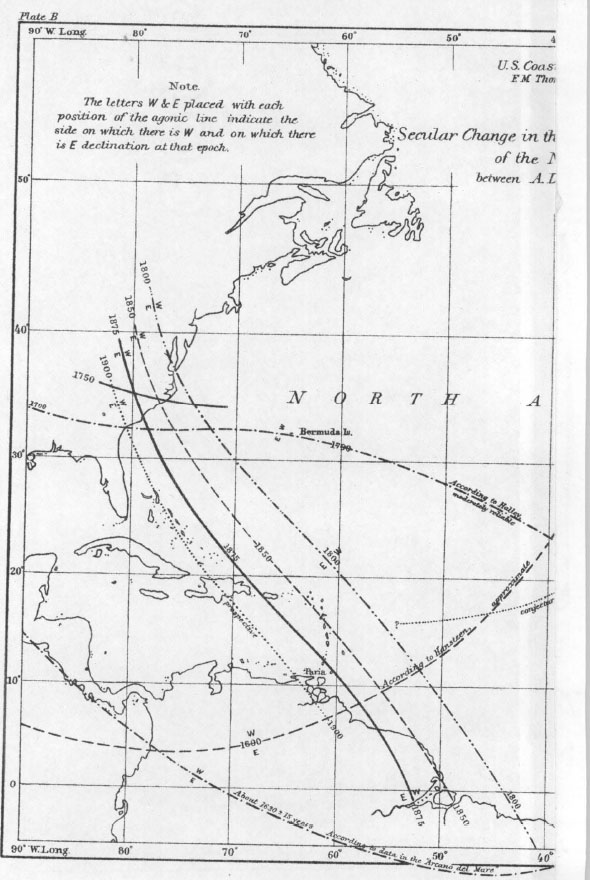
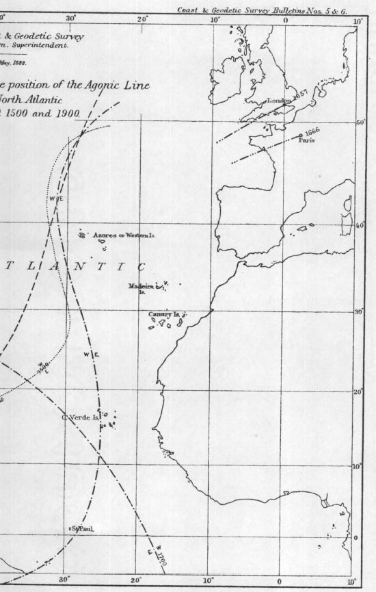
The meridian proper to the poles of the magnet, to which Davis refers, was of course the agonic line, now so called, the line of no magnetic declination, which at the time Davis wrote passed through or near to the Azores. It is the way of agonic lines to be irregularly curved and they would seldom, if ever, coincide with meridians for any considerable distance. Their changes of positions together with the changes of positions of their companions, the isogonic lines, or lines of equal magnetic declination, are involved in the secular variations and changes of the magnetic declination which have of late years been the subject of such earnest scientific investigation. The agonic line in question may be considered as the same, though in a somewhat different position, as that across which Columbus passed on his first voyage to America. His compasses had been pointing to the east of north,—such having been the declination in Europe at that epoch,—up to September 13, 1492. At the first of the evening on that day the needles varied to the northwest, and the next morning about as much in the same direction. Hence at some time not noted on September 13, they must have pointed in, or passed by, the direction of the true north. On September 17 it was observed that the needles varied to the northwest a whole point of the compass.786 It has been calculated by Charles A. Schott, assistant in the United States Coast and Geodetic Survey Office, that at noon on September 13, Columbus was in latitude 28° 21′ and longitude 29° 16′,787 which last is nearly half a degree west of Fayal on the map of the Azores given by Walker.788
A second point of no declination was found or ascertained by Sebastian Cabot in 1497 or 1498. On his map Cabot placed it on the meridian 110 miles west of Flores of the Azores, and Schott estimates its latitude as approximately 46° or 47°.789 In the Bulletin cited above is contained Plate B entitled “Secular Change in the Position of the Agonic Line of the North Atlantic between A. D. 1500 and 1900,” a reproduction of which accompanies this paper. The line on this plate for A. D. 1500, the author states, is little more than a conjecture, and depends mainly on the two points of no magnetic declination found by Columbus and Cabot as above. He also says that we have further reason to suppose that this agonic line passed somewhere north of London, and at its other extremity was some distance south of the Greater Antilles, as shown on the plate. Later I shall call your attention to the agonic line on the plate for “About 1630 ±15 years,” and to the near approach of that line to the Azores.
Another authority, slightly later than Davis, is found in Thomas Blundeville His Exercises, the first edition of which, “containing sixe Treatises,” was published in 1594, and a “sixthe Edition corrected and augmented” and “Contayning eight Treatises” appeared in 1622. Under Treatise VI, “The Art of Navigation,” and Chapter XXVI, “How to find out the variation of the Compasse in euery Latitude,” the following passage occurs in the sixth edition, but does not appear in the edition of 1594:
But there be three causes which moue me to think, that the respectiue point [whereunto the needle of your Compasse wil alwayes turn in what part of ye world soeuer you saile] will never bee truly found out. First, for that the Meridian, which in these daies is supposed to bee the first Meridian passing through the Azores, & specially through the lies St. Marie, and Saint Michael. Is not that Meridian vnder which the Mariners compasse doth rightly point, as well vnto the pole of the Loadstone, as also to the North Pole of the world, for though Francis of Deepe found it so by his Compasse, yet diuers learned Pylots since his time hauing sailed vnder ye Meridian, haue found the variation of their compasse to be as much there, as else where, and not rightly to point to the respectiue point, which is supposed to be vpon the earth, and without such a certain Meridian, no true account from any Latitude can be made. The second cause which moueth me to think as before, is for that the Compasse in some place of the Sea, will be suddenly retrograde, which thing Master Bourough790 by his own experience affirmeth to be true, as is before set downe. The third cause is, for that I doe verily beleeue, the finding out of the true place of the respectiue point, to be as great a secret in nature, as it is to know the cause why the Loadstone should haue such vertue to drawe steele vnto it, and to shew the North Pole of the world, which are two secret gifts giuen to that stone of God, for mans behoofe, and yet the cause thereof is not to be found but by man, though most carefully sought by the greatest Phylosophers that ever were (p. 689).
It is to be here observed that however Blundeville himself may have regarded the matter, he states that the meridian through St. Mary’s and St. Michael’s was at the time he wrote (before 1622) generally supposed to be the first meridian.791
From Blundeville His Exercises, edition of 1594, mentioned above, I take the following, which is under “A plaine Treatise of the first principles of Cosmographie,” and in Book II, Chapter VII, “Of the Longitude and Latitude of the Earth:”
Yet according to Ptolemie, that Meridian is saide to be first and furthest Westwarde which passeth through the Hands called Insulse Fortunate, for the West Indies were not knowne nor discovered in his dayes, nor yet long time after, since the discouerie whereof, the late Cosmographers of these dayes doe make the first Meridian to passe through the Hands called Azores, which Hands, as appeareth by their Cardes, are situated more Westwarde from the foresaid Insute fortunate by five degrees, the reason that mooueth them so to do, is because the Mariners Compasse, as they say, wil never incline to the true North pole, but when they saile either by the He S. Mary or S. Michaell, affirming that in euery other place the compasse doth varie from the true North, eyther by Northeasting or Northwesting (fol. 182).
On the Map of the World by Jodocus Hondius, 1611,792 the meridian marked 360° passes through St. Michael’s and St. Mary’s of the Azores.
I would now call attention to the Epitome of the Art of Navigation, by James Atkinson, which was published in London in 1711. Under Section ii of Chapter VI, “The Description and Use of the Terrestrial Globe,” certain problems are given, among them one “to demand the Longitude of the Lizard, in England,” to which the following note is appended:
The Globes formerly made in England begun Longitude at the Meridian of the Island of St. Michael, one of the Western or Azore Isles, which is West from the Meridian of London (according to the Mariner’s Compass Rectified, and also the Mariner’s Calendar) 23d. 36m. And accordingly the Lizard’s Longitude is 5d. 14m. West from London: This Difference in the Longitude of Places, is occasioned by the different Beginnings of Longitude by several Authors, which the Student is desired to consider (p. 158).
The problem in this case was solved by subtracting the longitude of the Lizard, as found on the globe, from the longitude of London, the longitude of both places being taken from St. Michael’s. It is evident that the object of the problem was to find the longitude of the Lizard reckoned from the meridian of London. The meridian of St. Michael’s was giving place to that of London as a prime meridian.
From the foregoing citations we are justified in assuming that Boston’s longitude of 315° was obtained by reckoning from the meridian of St. Michael’s. But though that meridian was regarded as the prime meridian here in New England in the seventeenth century, and was perhaps so treated by the majority of English navigators, it was by no means distinguished as such by the navigators and cosmographers of other nations. From the time of Ptolemy until the time of the discovery of America, longitude appears to have been reckoned for the most part from the meridian of the Canaries, those islands being during most of that period the farthest known lands to the west. This will appear from statements in some of the extracts from early authorities which I have included in this paper. After the discovery of America and the crossing of the agonic line, various prime meridians were in use by different navigators and cosmographers. These meridians were taken for divers reasons, some, as in the case of that of St. Michael’s, because they were supposed to coincide with the line of no magnetic declination, certain others because they crossed a national possession, while the meridian of the Canaries, or of Ferro the westernmost of them, still had its advocates by reason of its having been so long in use. The agonic line, being curved as stated above, would in different latitudes be encountered in different longitudes, though it was supposed by many for quite a period that it continued along a meridian of longitude. To show the locations of some of these prime meridians I will make reference to certain of the books and maps of the period. I sometimes quote literally in this paper, the better to reproduce the mental processes and the nicer shades of thought with which the authors dealt with these important questions of facilitating the process of ascertaining longitude. We are, moreover, now and then entertained with some choice specimens of the quaint English of the period.
The following passage, though taken from Blundeville under Treatise IV, “The Description and Use of Plancius his Vniuersal Mappe, set foorth in the yeare of our Lord, 1592,” is there given as setting down “the opinion of Mercator” (1512–1594), who published his Tabulae Geographicae in 1578–1584. It will be noticed that several prime meridians are here referred to.
Francis of Diep, a most skilfull Pilot, doth witnesse that the needle of the Mariners compasse, doth turne directlie to the North Pole, being in the Hands of Capo Verde, that is to say, the Ile of Sal, the Ile of Bonauista, and the Ile of Mayo, whereunto those doe agree very nigh, which doe say that the needle doth the like in the lies of Tercera and of S. Marie, which are part of the Flemmish lies, otherwise called Azores: but some others doe affirme, that the needle sheweth the North pole best, being in the He of Corvo, which is the furthest He westward of the said Azores, and because the longitude of places by most liuely reasons, ought to take his beginning from the common Meridian of the world, and from the rocke or Pole of the Adamant stone, we here following the opinion of those that are most skilfull in this matter, have set downe the first Meridian betwixt the lies of Capo Verde, and the Azores (fol. 264).
In the Arcano del Mare of Robert Dudley, Florence, 1646–1647, printed in Italian, the meridian of Pico of the Azores is given preference, as appears in the following passage (translated) taken from Book I, “On Longitude,” Chapter VIII, “As it is founded on the Variation of the Needle:”
In sailing from the coast of Spain and Portugal toward the Azores Islands and Tercera, the needle of the compass will be found to turn to the northeast, and always decreasingly, but when there is no longer any variation in the said needle, then the pilot may be sure that he is in the longitude of the island of Pico (p. 16).
In the maps in the Atlas of Nicolas Sanson d’Abbeville, Paris, 1656, longitude is reckoned from the meridian of Ferro of the Canaries.
In the map of the world in the North Star or Sea Atlas by Van Loon (Dutch), 1661, the meridian of 360° passes through the Canaries.
Andrew Wakely in his Mariners Compass Rectified,793 published before 1694—I am not sure of the exact time—used the meridian of London in making his tables.
In Peter Heylyn’s Cosmography, fifth edition, London, 1677,794 we find the following statements:
The AZORES are certain Islands . . . Situate betwixt the 38 and 40 degrees of Northern latitude; and one of them in the first Longitude; which is commonly reckoned from these Islands, as being the most Western part of the World, before the discovery of America (p. 236).
CORVO. . . . But this, though much smaller than the others, may in time be of more esteem than any of them, in regard it is conceived to be the most natural place for the first Meridian, . . . the Needle here pointing directly to the North, without Variation. Which whether it proceed from some secret inclination of the Load-stone to that part of the World, more in this place than any other; or that being situate between the two great Continents of Europe and America, it is drawn equally towards both, by the magnetical vertue of the Earth it self, I leave to be disputed by more able Judgments (p. 237).
In the map of America, however, at the beginning of Book IV, Part 2, the meridian of 360° runs just east of St. Michael’s.
In the Cartes de Géographie of Pierre du Val, Paris, 1679, and in his Géographie Universelle, Paris, 1682, the meridian of 360° runs by the west end of Ferro of the Canaries.
In the Atlas Minor of Nicholas Visscher, Amsterdam, 1690 (?), the meridian of 360° passes through Teneriffe of the Canaries. In A New Sett of Maps by Edward Wells, D.D., 1698 or 1699, on maps of Europe, 0° meridian passes through London.
The New Sea Atlas, London, 1702, says: “Azores . . . situate between 37 and 40 degrees of North Latitude: from the Flores of Corvo (or some of these Islands) Geographers use to begin their Longitude, as being the most Western part of the World, before the discovery of America” (p. 3). In some of the maps in this atlas, longitude begins at the Lizard.
M. de L’Isle’s Atlas, Amsterdam, 1710, puts the first meridian at the Island of Ferro, while meridian 350° passes through the west end of Terceira and through Pico, both of the Azores.
In the Atlas Minor of Carolus Allard, Amsterdam, 1710 (?), the meridian of 360° passes through the Madeiras.
The maps of Matthaus Seutter, Augsburg, 1720, make meridian 360° pass through Teneriffe of the Canaries.
From A New General Atlas, the maps of which “are all Engraven or Revised by Mr. Senex,” London, 1721, I quote the following as being an excellent summary of the number of prime meridians then in use:
Though the Western Nations agree to fix it [the first meridian] in the West of our Continent, they don’t agree on the Place where. Ptolemy, and the Ancients, fix’d it at one of the Fortunate Islands, now generally suppos’d to be the Canaries. Some of the Arabians follow’d him, and others plac’d it at Hercules’s Pillars, or the Streights of Gibraltar. Some Moderns would fix it at the Tercera, others at the Isles of Cape Verd or Cape Verd it self, and some at the Pike of Teneriff, one of the Canaries. The Spaniards would have it at Toledo; the Portuguese at Lisbon; and, in short, every Nation may fix it at their own Capital if they please; but as Ptolemy has been follow’d by most, ’tis like so to continue, especially since Lewis XIII of France did, by the Advice of the ablest Mathematicians, publish an Order of April 23, 1634, that it should be fix’d by his Subjects at the Isle of Fero, the most westerly of the Canaries.
It is now become usual to count the Longitude westward as well as eastward from the Place where Geographers fix their first Meridian.
The Difference among ’em [the geographers] about fixing this Meridian has made great Confusion in their Maps, and occasion’d much difficulty in finding the Longitude of Places, . . . The only way to remedy this at present is, to give an account of the different Places where they fix their Meridians, and of their Distances from one another.
The Spaniards, since their Conquest of the West-Indies, place their first Meridian at Toledo; and from thence, contrary to all other Europeans, account their Longitude from East to West.
Bleau, the Dutch Geographer, and most of his Countrymen, place it at the Pike of Teneriff, one of the Canaries.
The French, as we have heard already, generally fix theirs at the Isle of Fero, and some of them at Paris.
Our English Geographers, as Camden, Speed, and others, fix it in the Azores Islands; some at the Isle of Corvo; and others, which is most foliow’d, at the Isle of St. Michael’s; and later ones place it at London (p. 6).
On the Map of the World in this atlas (Senex’s) the meridian of London is marked 360, and longitude is reckoned eastward. On the Map of Europe, the meridian of London is marked 0, and longitude is reckoned both east and west from it. The other maps also appear to reckon from London in both directions.
In John Barrow’s Navigatio Britannica, London, 1750, in Chapter VIII, “Of Navigation,” pages 157–158, it is stated that the first meridian is variously placed by geographers, but that most of the English use that of London, and from this meridian longitude is reckoned both eastward and westward till it terminates in 180°, the opposite meridian.
From the Massachusetts almanacs of the period of Barrow’s publication it would appear that their authors were among those making use of the longitude of London.
It will now be interesting to locate as nearly as we may the positions occupied by the agonic line, to which we have referred, during the sixteenth and seventeenth centuries. Fortunately some of the publications of the United States Coast and Geodetic Survey will give us great assistance to this end. Besides its other work regarding terrestrial magnetism, that organization has made historical compilations on the subject of magnetic declinations throughout the earth and of their variations and changes during the last few centuries; for it is only by having data extending through a long period of time that the laws governing the mysterious workings of the earth’s magnetism can be ascertained. Of the series of papers on this subject issued by the Survey I have already referred to Bulletin No. 6 dated June 7, 1888. I would now call your attention to United States Magnetic Declination Tables and Isogonic Charts for 1902, etc., by L. A. Bauer, Chief of Division of Terrestrial Magnetism, second edition, referring especially to the division or chapter entitled “Principal Facts Relating to the Earth’s Magnetism,” pages 11 to 77 inclusive, as covering valuable historical material bearing upon the period we have in mind. I have reproduced the illustration on page 44 entitled “Fig. 8.—Comparison of the secular change curves of the magnetic declination at various stations in the Northern Hemisphere,” and incorporate it herewith. By following down the curve on Figure 8, bearing the name of any place we may find the estimated east or west compass declination at that place at any time between the years 1500 and 1900. The curve marked “Fayal Island, Azores” is the one which chiefly concerns us. Regarding this curve the following statement is made in the text:
In the case of Fayal Island it will be noticed that prior to 1600 two curves, one in full and the other broken, are given; the broken curve represents a repetition of the same law which governed the secular change at this station between 1600 and present date, while the full curve has been drawn to harmonize with the observations back to the time of Columbus. It will be seen that there is a marked difference between the two curves for the date 1500 (pp. 43–44).
From this language I do not understand the author to mean that the full line prior to where the broken line parts from it in 1600 is incorrect, but only that its position is not so fully substantiated as it is after 1600. At any rate the curves show at least that for some seventy-five years previous to 1650 the declination on Fayal was not more than 2½°; and that at a time shortly after 1650, viz. where the curve crosses the 0° line, there was no declination at Fayal; in other words, that the agonic line then passed through that island.
As one approaches an agonic line from either side, the magnetic declinations of the isogonic lines which are successively crossed become less and less up to the zero point of the agonic line. The island of St. Michael differing from Fayal only by about three degrees of longitude and slightly less than one degree of latitude, the magnetic declination of that island from, say, 1570 to 1660 could have differed only slightly from that of Fayal, or from that of Pico, which is very close to Fayal. In like manner the declination of Corvo, which is about two and a half degrees west of Fayal, could not have differed much from that of Fayal, or much even from the declination of St. Michael’s. Mariner’s compasses were not always adjusted in the same manner; in the case of such differences their respective needles would not point in strictly identical directions.795 As a further consequence the compass needle of one navigator would point due north in one place and that of another in a different place.
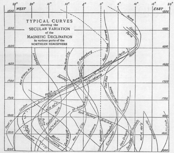
Fig. 8.—Comparison of the secular change curves of the magnetic declination at various stations in the Northern Hemisphere,
It appearing then from Figure 8 and Plate B and the other authorities cited, that during the latter part and perhaps the whole of the sixteenth century and the first half of the seventeenth century the agonic line in question ran near or through the Azores, we can well understand how one or more navigators or cosmographers came to select the meridian of Pico for instance as an initial meridian, and certain others that of St. Michael’s.
It will be noticed that on said Plate B there are given agonic lines for 1700, 1800, etc. In the text of Bulletin No. 6 the author says:
We may remark that the change between 1600 or 1630 and 1700 should not be conceived as having been produced by a great sweep of the northern portion of the agonic curve across Europe and Africa, but rather as a gradual breaking through of the narrow neck of east declination in the vicinity of Cape Verde islands, and thus readily uniting with the previously existing southern branch of the agonic line, which, in 1600, skirted the southwestern coast of Africa. The isolated patch of east declination thus produced apparently drifted off to the eastward and northward (p. 33).
By referring again to Figure 8 it will be observed that the curve of London crosses the line of no variation soon after the year 1650. In the text of the Magnetic Declination Tables for 1902 (page 41), the author states that about 1658 the needle at that place stood truly north and south, whereas about 1580 it was at a maximum of 11° or 11¼° E. And in Table II, “Showing the secular change in the magnetic declination at various places,” on the same page it appears that in 1660 the declination at London was 0°.59 W. and at Paris 0°.86 E. Again consulting Figure 8 it appears that after, say, 1653, the west declination at Fayal rapidly increased until by 1750 it had reached about 15 degrees. From the above it appears that by 1660 the agonic line had lost its characteristic of running in a direction nearly north and south, and was also drifting away from Fayal and the Azores. The reason, therefore, why longitude should begin at St. Michael’s, given by John Davis and by other writers, no longer existed. But books, including almanacs, globes, and maps, had been published giving the meridian of St. Michael’s as the prime meridian or reckoning the longitude of places therefrom and many navigators had become used to that meridian; and there would be no reason for changing unless a decided advantage in having a new prime meridian should become apparent. The existing way of reckoning longitude continued, I infer, until towards the close of the seventeenth century. At that period, as we have seen, the longitude or meridian of London (which I understand to have been the same as that of Greenwich) appears more or less in evidence as the prime meridian. The use of this as the initial meridian kept on increasing, I assume, until it became fixed and established for Britain and her colonies by the publication of successive numbers of the Nautical Almanac, which began in 1766, as I have before stated.
I have spoken of the changes of the compass declination and of the changes in the position of the agonic lines. It is stated by Charles A. Schott that the first writer who clearly asserted the existence of a change in the declination with time was Henry Gellibrand (1597–1636) of Gresham College, England. In 1635 he published his work entitled A Discourse Mathematicall on the Variation of the Magneticall Needle, together with its admirable Diminution lately discovered. Previous to the announcement of his discovery it was the general belief that the declination at any one place was invariable. Now, however, the fact of the secular variation became completely established, and it remained to later times to determine its extent and develop the law governing this change, and to endeavor to find its cause.796 In Bulletin No. 5 (page 25), referred to in footnote 1, Schott states that among the methods of finding the longitude at sea, the author of the Arcano del Mare797 brings forward, as others had done before him, one that depends on the observed changes of the magnetic declination. And on page 26 of Bulletin No. 5 he has a footnote which has such a direct bearing upon the matters herein treated that I quote it in full:
The adoption of one of the islands of the Azores for the location of the initial meridian in counting longitudes is said to have come about through the circumstance that at the time of adoption the variation of the compass-needle was zero or nearly zero at those islands, but for positions to the eastward the variation was easterly and increasing with distance from them, and for positions to the westward the variation was westerly and increasing. The temporary selection of this initial meridian is thus connected with the great problem of determining longitude at sea by the aid of the direction of the horizontal magnetic needle.
The only uniformly continuous and accurate way of ascertaining longitude at sea is, of course, through the exact measurements of intervals of time. But there was no means by which navigators could do this prior to the perfecting by John Harrison of his marine time keepers in or about the year 1761.798 At the period in mind, however, approximate compass declinations at divers positions of ascertained latitude and longitude on the Atlantic had become known, and the observation of the changes from one declination to another during the progress of a voyage must have been of assistance in estimating longitude.799
In connection with what has gone before I ask a moment’s attention to the paper on Winthrop’s Course across the Atlantic before referred to, and to the sketch accompanying it. It is there stated that the purpose of Winthrop’s navigators appears to have been to reach a position directly north of the Azores at or near the parallel of 43° 15′ and then to run down that parallel and sight Cape Sable. Winthrop in his Journal does not refer to a prime meridian through St. Michael’s or other island of the Azores, but he says that on April 29 (1630) they were “near the meridian of the Terceras” and that on May 9 they were supposed to be a little west of Corvo.800 These statements, together with the fact that they turned to due west at a point north of the Azores, may have a tendency to show that this westerly course began at or near what they considered the prime meridian, or at or near the place where their compasses showed no declination.
From the authorities cited it appears that in Massachusetts during a period of somewhat over sixty years after the landing at Plymouth longitude was reckoned from the so-called meridian of St. Michael’s, and in the easterly direction only; that during this period and for the anterior period back to the time of Elizabeth, the same meridian was also made use of by most English navigators and geographers as a prime meridian; that the meridian of St. Michael’s acquired this distinction because the agonic line had run close to it in a general north and south direction through several degrees of latitude for a good many years, and because by many the agonic line was supposed to coincide with it; that divers other prime meridians were in use during said period by the navigators and geographers of other nations; and that some of these prime meridians ran across other islands of the Azores, certain of them having been selected because, as in the case of the meridian of St. Michael’s, the agonic line was supposed to coincide with them, and one or more, perhaps, because they were the meridians of the most westerly lands known for a substantial period before the discovery of America.
I submit the foregoing historical material and conclusions, believing that they are important to have in mind in the consideration or treatment of matters pertaining to navigation in the seventeenth century.
Mr. Henry H. Edes, the delegate appointed by the President to attend the inauguration of Mr. Abbott Lawrence Lowell as President of Harvard College on the sixth day of October last, made an oral report. He described the ceremonies in the College Yard in the presence of a vast concourse of the alumni and distinguished guests, the choral singing, the conferring of honorary degrees on thirty eminent scholars, the hospitality extended to the delegates and the ladies accompanying them, the meeting of the Harvard Alumni Association in Memorial Hall, the luncheon given by President and Mrs. Lowell, the evening concert by the Boston Symphony Orchestra, the spectacular students’ celebration in the Stadium, the reception and afternoon tea at the new Medical School, and the dinner given by the Corporation at the Harvard Union in honor of the delegates. He also described the brilliant pageant on the morning of the inauguration when the more than two hundred delegates, in academic robes and hoods of many colors, marched in procession from Phillips Brooks House to the platform built in front of University Hall; and the equally brilliant scene on the following morning when the delegates, similarly attired, marched to Sanders Theatre to be formally presented to the newly-installed President. Mr. Edes called attention to the fact that among the delegates representing the principal universities, colleges, and learned societies of Europe and America, were seven of our own fellowship—President Arthur Twining Hadley of Yale, who, at the presentation in Sanders Theatre, spoke on behalf of the American delegates, Franklin Carter of Williams College, Waldo Lincoln, President of the American Antiquarian Society, Frederick Jackson Turner of the University of Wisconsin, Horace Davis of Leland Stanford, Jr., University, Henry Lefavour of Simmons College, and the delegate from this Society; and that our associates Dean William Wallace Fenn, Mr. Morris Hickey Morgan, and Mr. William Coolidge Lane had prominent parts in the ceremonies attending the induction of Mr. Lowell to office. Mr. Edes also mentioned that at the dinner, with which the celebration closed, several pieces of the ancient College silver were on the President’s table, including the “Great Salt,” given in 1644 by Mr. Richard Harris of Cambridge; two large loving-cups, with covers, given early in the eighteenth century,—one by Lieutenant-Governor Stoughton, the other by Colonel William Browne of Salem; and a bowl, formerly owned by President Holyoke, given in 1903 by his descendant, Miss Charlotte Augusta Hedge.801
Most of the learned bodies that were represented at the inauguration sent addresses of salutation. That presented from this Society was as follows:802
To The President and fellows of Harvard College The Colonial Society of Massachusetts
Sends Greeting
Upon the momentous occasion of the inauguration of your distinguished scholar Abbott Lawrence Lowell, LL.D., as the twenty-fourth President of Harvard College, we avail ourselves of the privilege of transmitting to you by our Associate Henry Herbert Edes our profound felicitations
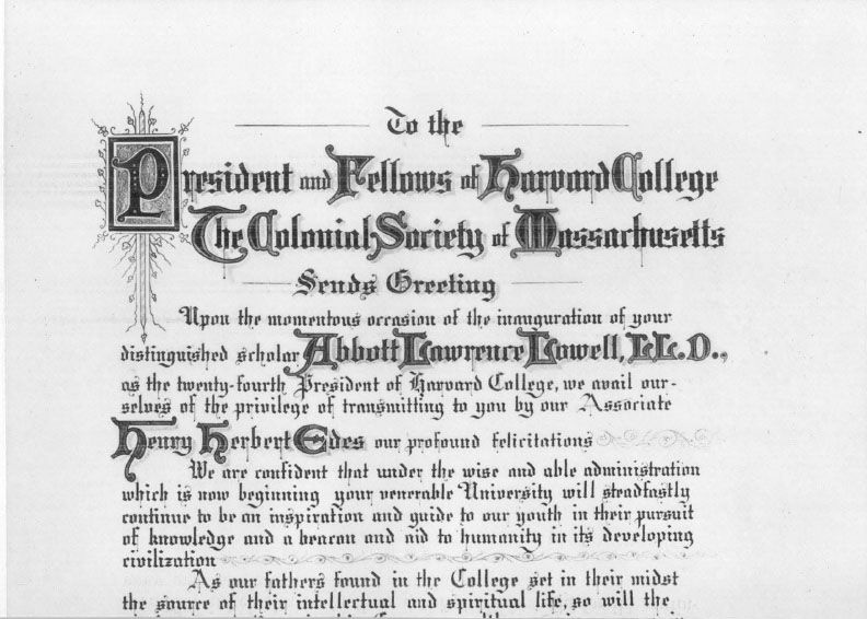
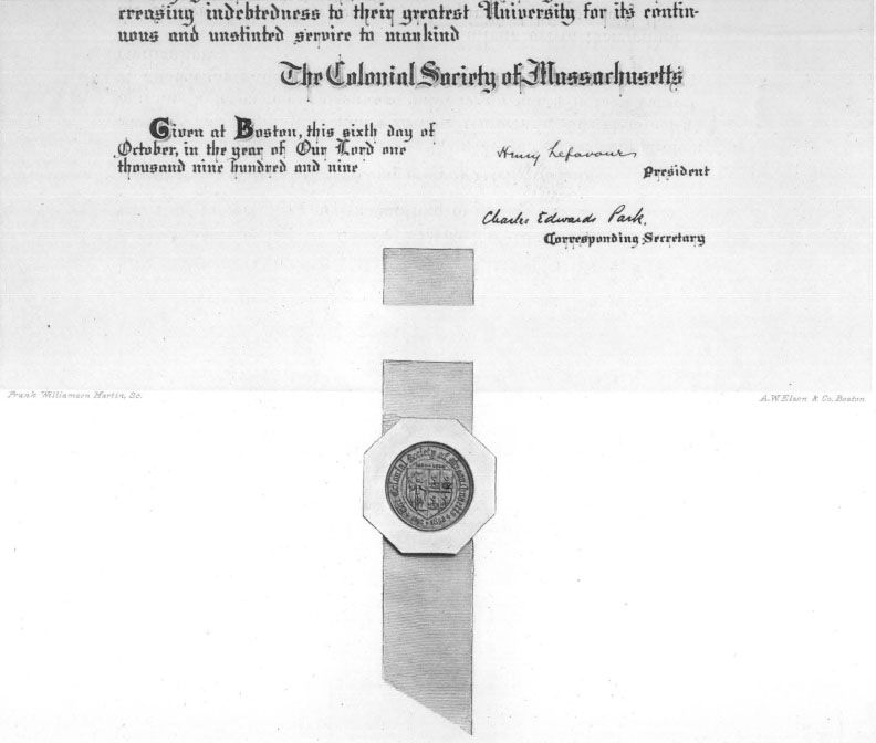
We are confident that under the wise and able administration which is now beginning your venerable University will steadfastly continue to be an inspiration and guide to our youth in their pursuit of knowledge and a beacon and aid to humanity in its developing civilization
As our fathers found in the College set in their midst the source of their intellectual and spiritual life, so will the coming generations in this Commonwealth recognize an ever increasing indebtedness to their greatest University for its continuous and unstinted service to mankind
|
Given at Boston this sixth day of October, in the year of present Our Lord one thousand nine hundred and nine |
The Colonial Society of Massachusetts |
|
Henry Lefavour, |
|
|
President |
|
|
Charles Edwards Park, |
|
|
Corresponding Secretary |
The Rev. Dr. Edward Caldwell Moore of Cambridge was elected a Resident Member.
1 The title of this book is as follows:
The | Constitutions | of the | Free-Masons, | Containing the | History, Charges, Regulations, &c. | of that most Ancient and Right | Worshipful Fraternity. | For the Use of the Lodges. | London Printed; Anno 5723. | Re-printed in Philadelphia by special Order, for the Use | of the Brethren in North-America. | In the Year of Masonry 5734, Anno Domini 1734. | Reproduced in Facsimile by the R. W. Grand Lodge of Pennsylvania. | In the Year of Masonry 5906; Anno Domini 1906.
2 This paper was originally prepared to be read as a part of the memorial exercises at Cambridge which were held under the auspices of the Harvard Memorial Society, in honor of the three hundredth anniversary of Harvard’s birth. The material then collated relative to the construction of houses, etc., when worked into shape proved to be far in excess of the demands for the occasion, so that the paper had to be much abridged in reading; but in submitting it to the Colonial Society with a view to publication, the rejected matter has been restored.
3 Winthrop’s Journal, ii. 88, note by Savage.
4 Ibid. ii. 342.
5 Magnalia (1853), ii. 10.
6 Cotton Mather gives his father’s argument in full, as to the power of the College to confer degrees, in Magnalia, ii. 19, 20, and the degree itself, ii. 26.
7 Magnalia, ii. 10, 30.
8 Boston Record Commissioners’ Reports, vol. iii. p. iv.
9 Massachusetts Colony Records, i. 196.
10 Winthrop’s Journal, i. 237.
11 In “The Site of the First College Building at Cambridge,” in the Proceedings of the American Antiquarian Society for October, 1888, the “Way to Charlestown” is identified with Kirkland Street, and the inference is drawn that the town grant was north of Kirkland Street, as it is now laid out. There can be but little doubt that Kirkland Street represents the “Way to Charlestown,” but whether the way was not from time to time removed from place to place is another question. President Wadsworth’s location of the town grant within the Yard shows his opinion, and my own later views are expressed in “The College in Early Days,” in the Harvard Graduates’ Magazine for April, 1893.
12 Massachusetts Colony Records, i. 206.
13 Records of the First Church in Charlestown, Boston, 1880, p. 9.
14 “The 26 of the ii. Month” (Boston Record Commissioners’ Reports, vol. iii. p. iv.).
15 Records of the First Church in Charlestown, p. 165.
16 Frothingham’s History of Charlestown, p. 74.
17 In Pientissimum, Reverendissimumque virum, Johannem Harvardum, è suggestio Sacro Caroloensi ad cœlos evectum (Magnalia, ii. 33).
18 Frothingham’s History of Charlestown, p. 55.
19 Frothingham further says that in another division his lot was nearly a third larger than that of Mr. Symmes, and adds that on November 27, 1637, he had a grant of three and a half feet of ground for a portal (History of Charlestown, p. 74).
20 Boston Record Commissioners’ Reports, vol. iii. p. iv.
21 Diary, i. 446, 447.
22 Quincy’s History of Harvard University, i. 48, facsimile of the record.
23 Hutchinson’s Collection of Original Papers, p. 49.
24 Massachusetts Colony Records, i. 408; Palfrey’s History of New England, i. 298; Neal’s History of New England, i. 129, 130.
25 Hutchinson’s History of Massachusetts (1795), i. 431.
26 Journal, i. 33.
27 Winthrop, writing in 1633 of the proceedings against Saltonstall, Humphry, and Cradock, says that “the defendants were dismissed with a favorable order for their encouragement, being assured by some of the Council, that his Majesty did not intend to impose the ceremonies of the Church of England upon us; for that it was considered that it was the freedom from such things that made people come over to us” (Journal, i. 103).
28 His description in his mother’s will as “clarke” and in his marriage licence as “clìcum,” carries with it the probability that he was ordained in the Anglican Church.
29 Winthrop’s Journal, i. 219, 220.
30 Ibid. i. 220. The proceedings this day were replete with interest. Winthrop baffled Vane’s attempt at delay and finally compelled him against his will to proceed with the election by threatening to assume charge of the meeting himself, if Vane would not yield to the desires of the majority.
31 Winthrop’s Journal, i. 220.
32 Ibid. i. 220.
33 Ibid. i. 232.
34 Hutchinson’s History of Massachusetts, i. 64. Winthrop’s account is: “None of them met him & the Sergeants who had escorted the former Governor refused to perform that service for him alleging that such service had been performed on account of the man not the place” (Journal, i. 234).
35 Hutchinson’s History of Massachusetts, i. 65.
36 Winthrop’s Journal, i. 235.
37 Wonder-working Providence (1867), p. 72.
38 Massachusetts Colony Records, i. 74.
39 Ibid. i. 74, 76, 77, 79, 91, 109, 160 (wages); 126, 183 (sumptuary laws).
40 Massachusetts Colony Records, i. 88. Thomas Dexter was in March, 1632–33, set in the bilboes, disfranchised and fined 40 s. for reproachful and seditious words against the Government here established, and for finding fault to divers with the Acts of the Court, and for saying “this captious  t will bring all to naught, adding that the best of them was but an atturney” (ibid. i. 103).
Capt. John Stone, in September, 1633, for “confronting aucthority, abuseing Mr Ludlowe both in words and behaviur, assalting him & calling him a iust as,” was fined £100 and prohibited “comeing into this pattent, wthout leaue of the  , vnder the penalty of death” (ibid. i. 108).
41 Massachusetts Colony Records, i. 211, 212.
42 Journal, i. 322, 323.
43 Boston Record Commissioners’ Reports, ii. (second edition) 1.
44 Massachusetts Colony Records, i. 86.
45 Ibid. i. 75.
46 Ibid. i. 83.
47 Ibid. i. 111.
48 Ibid. i. 93.
49 The situation was sized up by Chalmers in the following words:
The colonists became at length dissatisfied with adjudications various and contrary, since every magistrate decided according to the equity of his own mind, without established laws to inform his judgment, or former precedents to direct his practice. Dissatisfaction soon swelled into clamor, and continued complaint produced ultimate reformation (Introduction to the History of the Revolt of the American Colonies, Boston, 1845, i. 50).
50 Winthrop himself contended that he was not in favor of a rigorous execution of the orders against those who were merely residents. He stated “that it was his judgment, that, in the infancy of the plantations, justice should be administered with more lenity than in a settled state;” and after some discussion he acknowledged “that he was convinced, that he had failed in over much lenity and remissness and would endeavor (by God’s assistance), to take a more strict course hereafter” (Journal, i. 178).
51 Magnalia, ii. 33.
52 Autobiography, p. 64.
53 Wonder-working Providence, p. 103.
54 Certain Select Cases Resolved, p. 49.
55 The memorandum made by Winthrop and published by Savage in the Addenda reads: “Mr. Harvard gave to the College about £800” (Winthrop’s Journal, ii. 342). The author of New England’s First Fruits, p. 12, says “one halfe of his estate, (being in all £1700) towards the erecting of a college, and all his Library.” Thomas Shepard says, “The Lord put it into the heart of one Mr. Harvard, who dyed worth £1600 to give halfe his estate to the erecting of the Schoole” (Autobiography, p. 64). Johnson in his Wonder-working Providence fixes the amount of the bequest at “near a thousand pounds” (p. 133).
56 Young’s Chronicles of Massachusetts, p. 374.
57 Hutchinson’s History of Massachusetts, i. 91; Johnson’s Wonder-working Providence, p. 31.
58 Magnalia, i. 80.
59 Winthrop’s Journal, i. 268.
60 Massachusetts Colony Records, i. 192.
61 Ibid. i. 201.
62 Winthrop calls them wigwams (Journal, i. 36, 38); Prince, booths and tents (Annals, p. 309); Scottow, huts and smoky cottages (Narrative of the Planting of Massachusetts Colony, 1694, p. 16); Hubbard, small cottages (History of New England, p. 134); Winslow, booths and huts (Good News from New England, 1648, 4 Massachusetts Historical Collections, i. 201)
63 Early Records of Charlestown, in Young’s Chronicles of Massachusetts, p. 374.
64 March 2, 1646–47, John Crocker vs. Thomas Shawe, “for coming into his house by pulling aside some loose pallisadoes, on ye Lords day, about ye middle of ye day” (Plymouth Colony Records, i. 111).
65 New Englands Plantation, in Young’s Chronicles of Massachusetts, p. 244.
66 Winthrop’s Journal, i. 48.
67 For references to wooden chimneys and thatched roofs, see Dudley’s letter to the Countess of Lincoln, March, 1631 (Collections New Hampshire Historical Society, iv. 248)
68 Boston Record Commissioners’ Reports, ii. 70.
69 Winthrop’s Journal, i. 54.
70 Magnalia, i. 311.
71 Winthrop’s Journal, i. 63.
72 Mourt’s Relation (1865), p. 9.
73 Scottow’s Narrative of the planting of the Colony, p. 40.
74 Boston Record Commissioners’ Reports, ii. 40.
75 Ibid. iv. 63. See also two charges in 1637 for daubing the meeting-house (Essex Institute Historical Collections, iv; Second series, i). Roger Clap describes the Castle as built with “Mud walls which stood for divers years” (Memoirs, Boston, 1731, p. 15).
76 Winthrop’s Journal, i. 82.
77 Ibid. i. 73.
78 Scottow’s Narrative of the Planting of Massachusetts Colony, p. 41.
79 Winthrop’s Journal, i. 87.
80 The Early College Buildings at Cambridge, Proceedings of the American Antiquarian Society for April, 1890.
81 It may seem unnecessary to devote so much time to the discussion of daubed walls in connection with the career of one whose mother was from Stratford and a contemporary of the poet who wrote the familiar lines—
Imperious Cæsar dead and turned to clay
Might stop a hole to keep the wind away.
82 “Bring paper and linseed oil for your windows” (Winslow in Mourt’s Relation, p. 142).
83 Young’s Chronicles of Massachusetts, p. 254. Capt. Smith says, “traine oyle with the splinters of the roots of pine trees for candles” (3 Massachusetts Historical Collections, iii. 38); Wood, New England’s Prospect (1898), p. 18.
84 Massachusetts Colony Records, i. 92 (corn), 97 (bullets), 140 (beaver), 208 (wampum).
85 Dunster’s list of these books comprehends 260 titles. Several of these titles indicated works published in several volumes. See A few Notes concerning the Records of Harvard College, Bibliographical Contributions, Library of Harvard University, No. 27. Quite recently a praiseworthy effort has been put forth to place upon the shelves of the Harvard Library a copy of each work named in the catalogue—a contemporaneous publication by preference. The study of the subject has revealed the fact that the library bequeathed by Harvard must have contained 373 volumes.
86 The effort to duplicate these volumes has disclosed the fact that many of them were octavos and some even smaller.
87 Winthrop’s Journal, i. 304.
88 Winthrop was not, apparently, opposed to its use. March 18, 1627, he wrote “We want a little tobacco. I had very good, for seven shillings a pound at a grocer’s by Holborn Bridge” (Journal, i. 350). The statutes referred to will be found in the Massachusetts Colony Records, i. 101 (use prohibited), 109 (constables to take note of persons), 136 (sale prohibited), 204, 206 (former laws repealed), 241–242 (new law against use).
89 Winthrop’s Journal, i. 377.
90 Ibid. i. 379.
91 Wood writes in 1634: “Four eggs may be had for a penny and a quart of milk at the same rate and when butter is six pence a pound and Cheshire cheese at five penc” (Young’s Chronicles of Massachusetts, p. 414).
92 When the Governor’s wife arrived in 1631 people sent him “fat hogs, kids, venison, poultry, geese, partridges, &c.” (Journal, i. 57). By 1633, the gardens had become productive, so that notwithstanding a scarcity of corn people lived well with fish and the fruit of their gardens (ibid. i. 108).
93 “For bread and beer, that it was denied to them betwixt meals, truly, I do not remember, that ever I did deny it unto them; and John Wilson will affirme, that, generally, bread and beer was free for the boarders to go unto” (Winthrop’s Journal, i. 310 note).
94 Thomas Dudley writes in 1631 to the Countess of Lincoln saying “having yet no table, nor other room to write in than by the fireside upon my knee” (Young’s Chronicles of Massachusetts, p. 305).
95 My attention has been called to the omission in the text of reference to the use of intoxicating liquors. Of course drunkenness was one of the troubles of that time. Numerous convictions are recorded for the offence, but at the period which I cover, all liquors were imported except strong beer. In 1630, Winthrop restrained the drinking of healths at his table, and so it grew little by little to disuse (Journal, i. 37). In 1635, he speaks of drunkenness occasioned by people running to the ships (ibid. i. 161).
96 I am indebted to Professor Kittredge for calling my attention to two things: first, the proverb “fingers were made before forks,” evidence in itself that the knife was not used by well bred persons for conveying food to the mouth; and secondly, to Chaucer’s description of the dainty manner in which the Prioress fed herself, obviously with her fingers, given in the Prologue to the Canterbury Tales. Thomas Shepard in one of his sermons calls attention to the danger accompanying the use of the knife in cutting one’s meat: “Its from the excellency of a knife to cut well, but to cut my finger with it when I should be cutting of my meat with it, ariseth not from the end of the knife, nor from the intention of him who made it” (Certain Select Cases Resolved, p. 7).
97 Montaigne’s Journal, iv. 210.
98 William T. Davis in his Ancient Landmarks of Plymouth (p. vii.) makes substantially the same observations as to the preponderance of napkins.
99 Massachusetts Colony Records, i. 210.
100 Young’s Chronicles of Massachusetts, p. 54.
101 “We could not follow them in our Armor” (Winthrop’ Journal, i. 199).
102 Massachusetts Colony Records, i, 125.
103 “Our men being completely armed with Corslets, muskets, bandoliers, rests and Swords.” Head pieces are also mentioned in this account. (Capt. John Underbill’s Newes from America, in Hart’s American History told by Contemporaries, p. 439.) Besides the expression, showing that the men were in armor—quoted in the note above—Winthrop, in another description in the same year, 1636, speaks of their being armed with corselets (Journal, i. 194).
104 Massachusetts Colony Records, i. 126, 183.
105 Boston Record Commissioners’ Reports, ii. 8, iv. 3.
106 Boston Record Commissioners Reports, iv. 22.
107 “He demands of the next man he met, what the signall of the drum ment, the reply was made they have as yet no Bell to call men to meeting” (Johnson’s Wonder-working Providence, p. 103).
108 Winthrop’ Journal, ii. 220.
109 Wonder-working Providence, p. 41.
110 See C. F. Adams’ Antinomianism (Prince Society), p. 251. Shepard did not take a very active part in the discussion relative to the heresy of Mrs. Hutchinson, and he evidently considered that he occupied a neutral opinion in the controversy, for he says that Newtown was “kept spotless from the contagion of opinion.” He was, however, one of a committee which examined Mrs. Hutchinson, and although he was not violent in his opposition to her, yet he joined in a report with Thomas Welde which was referred to several times in the discussion. It seems to me therefore that he must be considered as practically taking sides in the matter.
111 Cotton Mather is authority for the statement that the Clergy had “eminent skill in physick.” He says, “it is well known that until two hundred years ago, physick in England was no profession distinct from divinity.” Most of Charles Chauncy’s sons, six in all, were, he says, practicers of physic as well as clergymen (Magnalia, i. 475).
112 Magnalia, ii. 33.
113 It is known that Mrs. Harvard bore children by her second husband. It is probable that Wilson was thinking of these children when he composed his elegy. The form of the elegy, an address by Harvard to an assembly of graduates, involves the idea of the lapse of many years after Harvard’s death before such a gathering could have taken place. Wilson died in 1667 at the age of seventy-nine, and if we allow an interval of at least twenty-five years to have elapsed after Harvard’s death before the elegy was composed, it would make him seventy-five years of age when it was written. This may perhaps account for this expression in the elegy, as confusion of memory on his part. That this must have been so, becomes apparent when we take into consideration the date of Harvard’s marriage, April 19, 1636.
114 Massachusetts Colony Records, i. 183.
115 Ibid. i. 208.
116 Ibid. i. 217.
117 The close resemblance of this committee to the body to whom was entrusted the care and regulation of the affairs of the College in 1642, has led encyclopædists to record that members of the committee were at that time appointed Overseers of Harvard College.
118 Magnalia, i. 386.
119 Autobiography, p. 64.
120 5 Massachusetts Historical Collections, v. 447, note. George E. Ellis was one of the committee in charge of the publication of this volume and doubtless is responsible for this witty and appropriate quotation.
121 The assumption that Harvard’s will was nuncupative may be correct, but it does not rest upon direct evidence.
122 Publications, viii. 243, 244.
123 The Boston News-Letter of Thursday, 30 September, 1756, stated that “On Saturday last His Excellency embarked on board His Majesty’s Ship Mermaid, Washington Shirley, Esq; Commander” (p. 1/2).
124 Suffolk Deeds, ci. 164.
125 Suffolk Probate Files, no. 15,041.
126 Suffolk Deeds, cxxxv. 196. See also clxx. 48, 96, clxxvi. 13, 15.
127 Born in 1590 at Wethersfield, Essex, where his father the Rev. Richard Rogers held a lectureship from about 1577 to 1618, being repeatedly “suspended for Nonconformity though supported by the Puritan Lord Knolys.” Ezekiel Rogers’s elder brother, Daniel, succeeded his father, after an interval, in the Wethersfield lectureship. All three were of the University of Cambridge. See Victoria History of the County of Essex, ii. 52.
128 The History of Rowley, by Thomas Gage, with an Address by the Rev. James Bradford, 1840. Most of the information about Mr. Rogers is contained in the Address and in Appendix A to the Address.
129 This reminds one of the inability of the younger Weller to see his father in court.
130 Calendar of State Papers, Domestic, 1638–1639, pp. 430, 431.
131 Calendar of State Papers, Colonial, 1574–1660, pp. 263, 264.
132 Royal Commission on Historical Manuscripts, Report vii. App. p. 538.
133 There is a letter dated November 6, 1621, from Mr. Rogers to Lady Joan Barrington, the wife of Sir Francis, who was a daughter of Sir Henry Cromwell and so an aunt of the Protector (ibid. p. 543). Another letter dated September 28, 1626, tells of Mr. Rogers’s sickness and recovery (ibid. p. 543). In 1644 Sir Thomas Barrington died and was succeeded by his son Sir John, and Mr. Rogers wrote to Mr. John Kendall at Sir John Barrington’s on December 8 of that year—
A long letter about what the late Sir Thomas Barrington had promised him in the way of preferment. He alludes to his diligent attendance on and comfort to Sir Thomas “on his sad and deep distemper of melancholy; not only in the day but in the night watchings and midnight rising he (Rogers) did much to impare his health.” (On the back is the copy of an answer by Kendall dated 1 May, 1645, in which he says that Sir Thomas had left his son burdened with 10000 l) (ibid. p. 570).
Mr. Rogers wrote again November 9, 1645, and once more December 9, 1646: “He mentions that old Lady B. promised him 100 l, and that Mr. Bridge said that he himself paid it to Robert Barrington, to be sent to New England for Rogers.” On April 25, 1646, “John Barrington to Ezekiel Rogers in England.—Copy of a letter on the subject of Rogers’s claims.” Was he then in England? See also a letter of the Rev. Daniel Rogers, a brother of Ezekiel, of July 7, 1647 (ibid. p. 570).
134 Ibid. pp. 543, 570.
135 Barton Stacey, a tithing and parish in Hants. The parish includes also the townships of Bransbury, Drayton, and Newton Stacey.
136 Calendar of State Papers, Domestic, 1635, pp. 520, 521.
137 Magnalia (1820), i. 74.
138 Bond, Genealogies and History of Watertown, p. 995.
139 Massachusetts Colony Records, i. 170.
140 Trumbull, History of Connecticut, i. 11.
141 Johnson, Wonder-working Providence, pp. 75, 77; Holmes, History of Cambridge, 1 Massachusetts Historical Collections, vii. 15, 16; Contributions to the Ecclesiastical History of Connecticut, p. 86 note.
142 Winthrop’s Journal (1853), i. 214 note.
143 1 Massachusetts Historical Collections, ix. 154; Contributions to the Ecclesiastical History of Connecticut, p. 512; Stiles, History of Ancient Wethersfield, i. 24. But see Records of the First Church of Dorchester, Massachusetts, 1636–1734, p. vii. The records of the Windsor Church, now extant, do not embrace anything pertaining to its life at Dorchester, Massachusetts.
144 Colonial Records of Connecticut, i. 2.
145 Journal, i. 203.
146 New England Historical and Genealogical Register, xxxv. 21
147 Massachusetts Colony Records, i. 26, 103, 123.
148 New England Historical and Genealogical Register, iv. 230.
149 4 Massachusetts Historical Collections, vi. 580.
150 New England Historical and Genealogical Register, xlviii. 263.
151 Stiles, History of Ancient Windsor, i. 429.
152 Magnalia, i. 74.
153 Colonial Records of Connecticut, i. 7.
154 Holland, History of Western Massachusetts, i. 24.
155 New England Historical and Genealogical Register, xxxv. 21. Dr. H. R. Stiles, in his History of Ancient Windsor, i. 54, and of Ancient Wethersfield, i. 39, seems to confuse him with the Rev. Henry Smith, who later came over from England and became the minister in Wethersfield. See his Ancient Wethersfield, i. 154.
156 Hazard, Historical Collections, ii. 113.
157 Hazard, Historical Collections, ii. 118.
158 Trumbull says that this reads “inconvenient” in the manuscript Journals of the Congress (Historical Notes on the Constitutions of Connecticut, p. 5).
159 Hazard, Historical Collections, ii. 119.
160 Trumbull, History of Connecticut, i. 525.
161 Bowen, Boundary Disputes of Connecticut, 15.
162 Trumbull, History of Connecticut, i. 544.
163 Winthrop’s Journal, i. 477.
164 Massachusetts Colony Records, i. 160.
165 Dr. Henry Bronson states, I think mistakenly, that Mr. Welles was for a short time a magistrate under the Massachusetts commission. New Haven Colony Historical Society Papers, iii. 296.
166 Colonial Records of Connecticut, i. 12.
167 Collections of the Connecticut Historical Society, i. 13.
168 Burt, First Century of the History of Springfield, i. 152.
169 As late as 1639 there were probably not over fifteen men there. Green, Springfield, 1636–1886, p. 45.
170 Dwight’s Travels in New-England and New-York, i. 319.
171 New England Historical and Genealogical Register, v. 472.
172 2 Massachusetts Historical Collections, vi. 308.
173 Young’s Chronicles of Massachusetts, ii. 283.
174 Morris, Early History of Springfield, p. 11; Todd (The Burr Family) puts the date of his removal as 1644. He represented Fairfield in the Connecticut General Court in 1645, his name being enrolled as “Jehu Burre” (Colonial Records of Connecticut, i. 130).
175 Colonial Records of Connecticut, i. 10, 13.
176 Letter quoted in Taylor, Roger Ludlow, p. 70.
177 Massachusetts Colony Records, i. 192.
178 Winthrop’s Journal, i. 259.
179 Ibid. i. 260.
180 Colonial Records of Connecticut, i. 10.
181 Colonial Records of Connecticut, i. 11.
182 Ibid. i. 13.
183 Ibid. i. 19.
184 Johnson, Wonder-working Providence, p. 199.
185 Roger Wolcott’s Memoir, Collections of the Connecticut Historical Society, ii. 326.
186 Journal, i. 216.
187 This was on October 7, 1640 (Massachusetts Colony Records, i. 304). Connecticut assented in 1641 (Colonial Records of Connecticut, i. 64).
188 Winthrop’s Journal, i. 281.
189 Ibid. i. 284.
190 Letter of Thomas Hooker to Gov. Winthrop. Collections of the Connecticut Historical Society, i. 9; Winthrop’s Journal, i. 237, 285, 286.
191 Massachusetts Colony Records, i. 216.
192 Massachusetts Colony Records, i. 320, 321.
193 5 Massachusetts Historical Collections, i. 260.
194 Massachusetts Colony Records, i. 321.
195 Ibid. i. 229, 230, 232.
196 Hazard, Historical Collections, ii. 72.
197 Ibid. ii. 111.
198 Ibid. ii. 112.
199 Ibid. ii. 137.
200 John Winthrop, Senior.
201 Hazard, Historical Collections, ii. 139.
202 Journal, i. 319. Cf. i. 335.
203 5 Massachusetts Historical Collections, i. 264.
204 Ibid. “You” in this letter evidently refers generally to those who represented Massachusetts at the conference.
205 Winthrop’s Journal indicates that this conference occurred not in June but July, 1638. He speaks, under date of December 13, 1638, of these three men as having brought their Connecticut amendments to the attention of the General Court at Newtown (i.e. Cambridge) on “the of the 5th” (Journal, i. 342). This probably indicates simply a lapse of memory.
206 Winthrop’s Journal, ii. 428; Collections of the Connecticut Historical Society, i. 2.
207 Collections of the Connecticut Historical Society, i. 14.
208 Life and Letters of John Winthrop, ii. 422.
209 Journal, i. 344.
210 Colonial Records of Connecticut, i. 25, 26.
211 Colonial Records of Connecticut, i. 20, 24.
212 Ibid. i. 18.
213 Massachusetts Historical Society Manuscripts, 81. D. p. 4. I am indebted for this reference to the courtesy of Mr. Charles K. Bolton, the librarian of the Boston Athenæum.
214 New England Historical and Genealogical Register, xiii. 291; Holland, History of Western Massachusetts, i. 33; 5 Massachusetts Historical Collections, i. 487.
215 Green, Springfield, 1636–1886, pp. 29–36; quoted from the original manuscript now owned by Charles E. Oliver of Boston. The only date of the letter is the 18th day of the second month, but it was addressed on the back “To his lov. friend, Mr Pinchon, at his house in Aguam, lett these bee deld,” and on the first page is a marginal note, apparently in his handwriting, of its receipt on “the 20 April, 1639.”
216 Green, Springfield, 1636–1886, pp. 55, 60.
217 5 Massachusetts Historical Collections, i. 119.
218 Winthrop’s Journal, i. 360.
219 Colonial Records of Connecticut, i. 30, 31.
220 Burt, First Century of the History of Springfield, i. 144.
221 5 Massachusetts Historical Collections, i. 296.
222 Massachusetts Colony Records, i. 320–322.
223 Colonial Records of Connecticut, i. 57.
224 Trumbull, History of Connecticut, i. 115.
225 Massachusetts Colony Records, ii. 31, 35, 36; Colonial Records of Connecticut, i. 82.
226 Colonial Records of Connecticut, i. 90 note.
227 Colonial Records of Connecticut, i. 119, 185.
228 Hazard, Historical Collections, ii. 123.
229 Colonial Records of Connecticut, i. 139.
230 Hazard, Historical Collections, ii. 136.
231 A copy of this survey is given in Bowen’s Boundary Disputes of Connecticut, opposite p. 19. It runs the line below Enfield Falls. See further Bowen’s description of the territory included, in chapters iii and iv of his work.
232 Colonial Records of Connecticut, v. 390–399.
233 Colonial Records of Connecticut, ix. 431.
234 Johnston, History of Connecticut, p. 209.
235 Hazard, Historical Collections, ii. 142.
236 Massachusetts Colony Records, ii. 109.
237 Winthrop’s Journal, ii. 457.
238 Green, Springfield, 1630–1886, p. 63.
239 This letter, dated 15 March, 1793, is printed in Anne Cary Morri’s Diary and Letters of Gouverneur Morris (1888), ii. 38. The opening words—“I have receiv’d yours of the third of February and reply shortly that I may reply immediately. My Reason for which is that”—are omitted in the Diary and Letters, as are also the words printed in italics in the following sentence: “In the first Place I must have leave to resign from the President but further you will consider that the very Circumstance,” etc.
240 Publications of this Society, vi. 109–130.
241 For Boyle, see ibid. vi. 321 note 4, ix. index.
242 Palfrey, History of New England, i. 313.
243 Cambridge Modern History, iv. 275.
244 Ibid. iv. 266–275.
245 In the Massachusetts Colony Records (i. 36), under date of March 17, 1628–29, is the following entry:
A warrant was made ffor payment of 120t to Mr Nathaniell Wright, for so much pd by him to Mr Jarvis Kerke, Mr Wm Barkley, & Mr Roᵬrt Charlton, ffor the shippe.
The Jarvis Kerke here referred to is the Gervase Kirke named in the text, both forms of the name being found in the Calendars of State Papers. Thia entry was made a few days after the date of the Charter, March 4–14,1628–29, but before organization thereunder.
246 Henry Kirke, First English Conquest of Canada (1871), p. 69.
247 History of New England (1853), i. 15, 16.
248 Ibid. i. 17. Terceira is one of the large islands of the central group of the Azores. It is in slightly above 27° west longitude. Under date of May 9, Winthrop says that the fleet was a little west of Corvos. Corvo and Flores are the two islands comprising the northwestern group of the Azores and are in slightly above 31° west longitude. Upon the two estimates the fleet made about four degrees of longitude in ten days.
249 History of New England, i. 17, 18, 21.
250 See Parkman, Pioneers of France (1896), p. 444; Winsor, Cartier to Frontenac, p. 136; Kirke, First English Conquest of Canada, pp. 69–74. In saying that “Champlain surrendered Quebec to the English on the 9th of August, 1629,” Henry Kirke is slightly inaccurate. The surrender of Quebec took place on July 20; the articles, drawn up July 19, were ratified on August 9 by David Kirke at Tadousac. See Calendar of State Papers, Colonial, 1574–1660, pp. 98, 99. The matter is correctly stated by R. Brown in his History of the Island of Cape Breton (1869), p. 73. The articles are printed in Hazard’s Historical Collections, i. 285–287.
251 Birch’s Court and Times of Charles the First contains letters bearing on the subject from the Rev. Joseph Mead to Sir Martin Stuteville dated September 26, 1629 (ii. 28), from Mr. Beaulieu to Sir Thomas Puckering dated January 20, 1629–30 (ii. 52), from John Pory to Puckering dated January 13, 1630–31 (ii. 89, 90), from Beaulieu to Puckering dated May 25, 1631 (ii. 122), from Pory to Puckering dated June 16, 1631 (ii. 123), and from Pory to Puckering dated February 23, 1631–32 (ii. 171, 172). In his letter to Puckering of January 13, 1630–31, Pory, with pleasing naïveté, writes:
That Philip Burlamachi hath gotten a brave employment into France, to fetch home the latter half of the Queen’s portion, being £120,000, and satisfaction also for three great rich English ships, treacherously taken by the French after the peace proclaimed. “Do you think that the French, being so exhausted by their wars, would part with such heaps of treasure for nothing? No: you may be sure they would not. The bait, therefore, to allure them thereunto, is the fort of Kebeck, in Canada, to get it out of Capt. Kirk’s clutches; the trade of beavers and otters, which they want to enjoy by the possession whereof, having been worth unto them, communibus annis, £30,000 by year.” That the said fort sticketh in their hearts, as Calais did in Queen Mary’s.
252 Kirke, First English Conquest of Canada, pp. 82–86; Calendar of State Papers, Colonial, 1574–1660, pp. 117, 118.
253 In a note to Winthrop’s History of New England (i. 15), Savage says that “Capt. Kirk” was “probably a brother of Sir David Kirk.”
254 Kirke, First English Conquest of Canada, p. 93.
255 Mosquitoes.
256 Kirke, First English Conquest of Canada, p. 87.
257 Parkman, Pioneers of France, p. 444. In Rymer’s Foedera (xix. 303) is a promise of Charles I to return Quebec to the French King dated June 29, 1631.
258 Winsor, Cartier to Frontenac, p. 137. The Treaty of St. Germain has been printed several times in French, but not in English. See Rymer’s Fœdera, xix. 361–365; Memoires des Commissaires (1755), ii. 7–13; Collection de Manuscrits relatifs a la Nouvelle-France (1883), i. 86–97; Hazard, Historical Collections, i. 319, 320.
259 See E. F. Slafter, Sir William Alexander, and American Colonization (Prince Society), pp. 62–72.
260 Winsor, Carrier to Frontenac, p. 138.
261 Ibid. p. 138. In a letter to John Winthrop, Jr., dated London, December 26, 1631, Francis Kirby wrote:
Captain Bruton who was imployed by my cozen Moris Thomson and company for the trade of bever in the river of Canada is now arrived heer . . . he hath brought in heer about 3000lb weight of bever, and they are now hasteninge to set forth a small ship only for that river hopinge to be there before Captain Kerke whom (I hear) Is to fetch his men from Quibeck and yield up the Castle againe to the French this next somer (3 Massachusetts Historical Collections, ix. 238).
It would appear from these statements that the English were making the most of their control of the River St. Lawrence while it lasted.
As contemporary glimpses of the Kirkes are somewhat rare, it may not be without interest to bring together a few. In a relation written at Quebec August 28, 1632, Father Le Jeune said:
At length, on the 5th of July, which was Monday,—two months and 18 days since the 18th of April, when we sailed,—we reached the much desired port. We cast anchor in front of the fort which the English held; we saw at the foot of this fort the poor settlement of Kebec all in ashes. The English, who came to this country to plunder and not to build up, not only burned a greater part of the detached buildings which Father Charles Lallement had had erected, but also all of that poor settlement of which nothing now is to be seen but the ruins of its stone walls. This greatly inconveniences the French, who do not know where to lodge. The next day Captain Thomas Ker was summoned, a man of French Nationality, born at Dieppe, who had gone over to England, and who, with David and Louys Ker, his brothers, and one Jacques Michel, also born at Dieppe, all huguenots, had thrown themselves upon this poor country, where they have done great damage and have prevented the doing of much good. . . . The English Clergyman, who was not of the same Faith as his people,—for he was a Protestant or Lutheran, and the Kers are Calvinists or of some other more libertine Religion (they held this poor Minister a prisoner in their house for six months),—told me that the Moutagnards wanted to negotiate a peace with the Hiroquois (Jesuit Relations and Allied Documents, v. 39, 41, 49).
Under date of July 25, 1645, Governor Winthrop wrote:
Monsieur La Tour having stayed here all winter and thus far of the summer, and having petitioned the court for aid against Monsieur D’Aulnay, and finding no hope to obtain help that way, took shipping in one of our vessels which went on fishing to Newfoundland, hoping by means of Sir David Kirk, governour there, and some friends he might procure in England to obtain aid from thence, intending for that end to go from thence to England. Sir David entertained him courteously, and promised to do much for him; but no means of help appearing to answer his ends, he returned hither before winter, Sir David giving him passage in a vessel of his which came hither (History of New England, ii. 303).
In a letter to John Winthrop, Jr., dated New Haven, September 26, 1659, the Rev. John Davenport said:
I desire . . . to let you know that I have received a large letter fr: Mr Blinman dated Aug. 22. whereby I understand that God hath brought him and his to Newfoundland, in safety and health, . . . After these passages and his notifying to me the Lady Kircks respectful and loving mention of me whom she saith, she hath heard in London, he addeth to what I had heard fr: England that a fine of 5£ is put upon any that shall name the last protector (3 Massachusetts Historical Collections, x. 25, 26).
No doubt this was the widow of Sir David Kirke.
262 W. A. Shaw, Knights of England, ii. 201.
263 Kirke, First English Conquest of Canada, p. 161 and note.
264 Kirke, First English Conquest of Canada, p. 167.
265 Shaw, Knights of England, ii. 215. In his History of Newfoundland (pp. 155, 162, 164), Judge Prowse speaks of “Sir James Kirke.” This is apparently a mistake, for in the documents from the Calendars of State Papers referred to by Prowse James Kirke is not spoken of as a knight, nor is his name found in Shaw’s work. On the other hand, John Kirke, though his name too is not in Shaw’s work, was knighted, though exactly when does not appear. On May 14, 1683, there is mention of a “Petition of Sir John Kirk, Knight, to the King” (Calendar of State Papers, Colonial, 1685–1689, p. 643), and on January 26, 1684, of “Sir John Kirk” as the father-in-law of Radisson (ibid. p. 648). The second wife of Radisson is sometimes erroneously said (Jesuit Relations and Allied Documents, v. 277) to have been the daughter of Sir David Kirke. Radisson himself said that he was “marry’d at London unto an Honble familly,” and spoke of “my father-in-Law, Sir John Kirk” (Voyages of Peter Esprit Radisson, Prince Society, pp. 250, 254).
266 R. Brown, History of the Island of Cape Breton, p. 112 note; Kirke, First English Conquest of Canada, p. 173.
267 That from the autumn of 1651 to June 11, 1652, Sir David was in London, as stated by Henry Kirke, is shown by the Calendar of State Papers, Colonial, 1574–1660, pp. 363, 371, 372, 373, 381. Henry Kirke writes:
At the same time [i.e., June 11, 1652], permission was granted to Sir David to return to Newfoundland, on condition that he returned to England with the Commissioners, and in the meanwhile gave security that he would answer whatever was objected against him, and to pay such sums as shall appear to be due from him to the Commonwealth. Upon such hard terms as these, Sir David Kirke returned to his estates at Ferryland, in the summer of 1652. He could not have remained there long, for in the spring of 1653, we find him again in England, . . . he was allowed to return to Newfoundland, upon entering into a bond of double the value of his estate, to answer any charges that might be brought against him. With such terms, which were the best he could procure, Kirke was bound to be satisfied; so he set sail for Newfoundland and arrived there in the autumn of 1653. . . . But all hopes and expectations were blighted by his death, which took place in the winter of 1655–6, but the exact date is not known. (First English Conquest of Canada, pp. T77–184.)
Henry Kirke offers no proof that Sir David returned to Newfoundland in the summer of 1652 and again in the autumn of 1653, and, while the statement may be correct, there is nothing in the Calendar of State Papers to support it. As to the date of Sir David’s death, Henry Kirke is clearly wrong. On June 11, 1653, a petition of Sir David was referred to the Committee of the Admiralty, and on December 1, 1653, an order of the Council of State referred the petition to the Committee for Irish and Scotch Affairs. On April 24, 1654, Sir David was spoken of as dead. (Calendar of State Papers, Colonial, 1574–1660, pp. 404, 412, 415.)
268 “In the full conviction,” writes Henry Kirke, “that the Baltimores had abandoned Newfoundland, Sir David Kirke obtained a grant of that place from the King, . . . This was in 1637, and no complaint was made by Lord Baltimore till 1660” (First English Conquest of Canada, pp. 188, 189). As early as February, 1637, Lord Baltimore presented a memorial “touching his right to part of Newfoundland” (Calendar of State Papers, Colonial, 1574–1660, pp. 246, 247). On June 11, 1652, the Committee for Foreign Affairs considered “the interests of the Commonwealth in Newfoundland, and the encouragement of the fisheries there;” and “Sir David Kirke and Lord Baltimore, who pretend private interest, agree that the proceeding therein will be no inconvenience to them” (ibid. p. 381). The Maryland Historical Society owns several documents relating to the subject dated 1652 or 1653, among them “the Lord Baltimore’s case concerning Avalon” (Calvert Papers, part i. p. 113). Under date of June, 1660, is a—
Petition of Cecil, Lord Baltimore to the King. Recites King James’s patent of Newfoundland to his father; where he began a plantation, built a fair house in which he resided, and expended above 30,000 l. After his decease, the petitioner deputed Capt. William Hill, Governor. In 1638 . . . Sir David Kirke surreptitiously obtained a patent, went over the following year, and dispossessed the petitioner of all his rights there. In 1655 Kirke made over part of his patent to John Claypole (son-in-law to Cromwell), . . . and others, and Sir Lewis Kirke and others are endeavouring to get a confirmation of that patent. Prays that no grant may be passed to his prejudice, and that he may be restored to his rights according to his patent (Calendar of State Papers, Colonial, 1574–1660, p. 481).
It has been stated that the Kirke who in 1655 “over part of his patent to John Claypole” was Sir David; but if the date is correct, Sir David was then dead; hence probably it was James Kirke, or else there was a mistake in, the date. A little later than the above petition, we find, presumably dated in 1661, another—
Petition of Cecil Lord Baltemore to the King. Recites his former petition and the proceedings thereon . . . ; with his Majesty’s order (of 20th March 1660/1) to restore petitioner to his possession and rights in Newfoundland, but that he hath yet no satisfaction for such damage done him by Sir David Kirke and others in dispossessing petitioner of his house, goods, and rights in the province of Avalon, and keeping him out of possession many years, to his prejudice of above 20,000 l. sterling, for which damages petitioner sued said Sir David Kirke at his first return thence into England about ten years since, and laid him in prison, where he died before making any satisfaction to petitioner. That nevertheless Sir Lewis Kirke claims satisfaction for the charges wrongfully bestowed by his brother upon said province to petitioner’s prejudice (ibid., Colonial, 1061–1668, p. 21).
Lord Baltimore appointed Captain Robert Swanley to be his lieutenant in Avalon, and on May 9, 1663, the King’s officers and subjects were “to be assisting to Capt. Swanley or his deputy in the Government of said province” (ibid. p. 132).
269 History of New England, i. 24. The following is the entry for May 30:
The wind N. by E. a handsome gale, but close, misty weather, and very cold; so our ship made good way in a smooth sea, and our three ships kept close together. By our account we were in the same meridian with Isle Sable, and forty-two and a half (ibid. i. 24).
270 That the colonists felt that they were in grave danger of hostilities by the French is shown by a statement in Thomas Dudley’s letter to the Countess of Lincoln, dated March 12, 1630–31, wherein Dudley, referring to the efforts of the colonists in July and August, 1630, to find a place for their sitting down, says:
And to that purpose, some were sent to the Bay, to search up the rivers for a convenient place; who, upon their return, reported to have found a good place upon Mistick; but some other of us, seconding these, to approve or dislike of their judgment, we found a place (that) liked us better, three leagues up Charles river; and thereupon unshipped our goods into other vessels, and with much cost and labor brought them in July to Charlestown. But there receiving advertisements, by some of the late arrived ships from London and Amsterdam, of some French preparations against us, (many of our people brought with us being sick of fevers and the scurvy, and we thereby unable to carry up our ordnance and baggage so far,) we were forced to change counsel, and for our present shelter to plant dispersedly, some at Charlestown, which standeth on the north side of the mouth of Charles river; some on the south side thereof, which place we named Boston, (as we intended to have done the place we first resolved on;) some of us upon Mistick, which we named Medford; some of us westwards on Charles river, four miles from Charlestown, which place we named Watertown; others of us two miles from Boston, in a place we named Rocksbury; others upon the river of Saugus, between Salem and Charlestown; and the western men four miles south from Boston, at a place we named Dorchester. (Young’s Chronicles of Massachusetts, pp. 312, 313.)
It thus appears that the danger of attacks by the French may have affected the locations of towns and town boundaries in the neighborhood of Boston.
271 Savage, referring to the capture of Quebec by the Kirkes, says (Winthrop’s History of New England, i. 13 note) that it was an event then and long after thought of so little consequence as not to be noticed in Hume’s History of England.
272 History of New England, chap. xiv.
273 History of New England, chap. lxxi.
274 This estate was at the southerly comer of what are now known as Washington and State Streets.
275 Mather, Magnalia (1702), book iii. chap. xxv. p. 144.
276 The Rev. John Wilson.
277 The Rev. John Norton.
278 See Massachusetts Colony Records (second edition), i. 37 f, 37 g, 37 h.
279 Original agreement in possession of the Massachusetts Historical Society.
280 Massachusetts Colony Records, iv. (part i.) 327.
281 Boston Record Commissioners’ Reports, ii. (second edition) 158.
282 For Oxenbridge in England, see index of Masson’s Life of Milton.
283 Mather Papers, in Catalogue of Prince Library, ii. 15; Suffolk Probate Files, no. 716.
284 Acadia was ceded to France by the Treaty of Breda, 1667, but was not actually turned over until 1670.
285 Both wills are given in Prime’s Some Account of the Temple Family, Appendix (1899), pp. 94–99.
286 The title-page has neither imprint nor date. It is generally assigned to the year 1670. In the address “To the Reader,” the Rev. Increase Mather, a brother of Samuel Mather, speaks of it as a posthumous work; and as Samuel Mather died October 29, 1671, the pamphlet obviously could not not have been printed before the end of 1671.
287 See John Dunton, Life and Errors (1818), p. 204.
288 John Usher (1648–1726).
289 4 Massachusetts Historical Collections, viii. 576.
290 Boston Record Commissioners’ Reports, vii. 162.
291 Diary, i. 141.
292 Foote, Annals of King’s Chapel, i. 45, 46.
293 Diary, June 27, 1671; August 3, 1671.
294 3 Massachusetts Historical Collections, vii. 162.
295 Diary, i. 159, 160, 162.
296 Boston Record Commissioners’ Reports, vii. 220.
297 See Boston Record Commissioners’ Reports, xi. 13, 14.
298 Ibid. xi. 26.
299 3 Massachusetts Historical Collections, v. 178.
300 Boston Record Commissioners’ Reports, xi. 37.
301 See Palfrey’s History of New England, iv. 295 note, quoting a letter from Governor Dudley to the Lords of Trade, March 10, 1705: “I have received her Majesty’s picture and coat of arms. The same were the next day fixed in the Council Chamber of this Province.”
302 See John Hull’s Diary, p. 150 note.
303 See Hutchinson’s History of Massachusetts (1767), ii. 187.
304 Sewall’s Letter Book, i. 422.
305 See Publications of this Society, viii. 19–21.
306 Boston Record Commissioners’ Reports, xi. 185.
307 5 Massachusetts Historical Collections, vii. 163.
308 Boston Record Commissioners’ Reports, xiii. 249.
309 See Publications of this Society, xi. 196–207.
310 Proceedings of the Massachusetts Historical Society, xviii. 422.
311 [The return of Mede’s book to the King’s Chapel Library came from a suggestion by Mr. Canavan.—Editor.]
312 Boston Record Commissioners’ Reports, xi. 240.
313 Sewall’s Letter Book, ii. 208.
314 See J. J. Ogle’s The Free Library (London, 1897), p. 11.
315 Report for 1899, p. 43.
316 The inscription has been kindly verified by Dean Wace of Canterbury Cathedral, who writes that the tablet is of white marble. It need scarcely be pointed out that the terms “British Colony of New England,” “British Forces,” and “American Commonwealth” would not have been employed by an American.
317 This silhouette of Bishop Cheverus belonged originally to the Rev. Dr. Eliphalet Pearson (H. C. 1773), a Fellow of the Corporation of Harvard College, and the first Principal of Phillips Academy, Andover. It was inherited by his daughter Margaret Bromfield Pearson, who married the Rev. 1. H. T. Blanchard (H. C. 1817), the Unitarian minister of Harvard, Massachusetts, and always adorned the wall of her chamber. At her death it passed to her kinsman our late associate Dr. Daniel Denison Slade, and is now the property of his son, Mr. Denison R. Slade. See Publications of this Society, v. 198 note, 205 note, viii. 290.
318 Jean Louis Anne Madeleine Lefebvre de Cheverus (1768–1836) signed himself, when Bishop of Boston, John Cheverus (Memorial History of Boston, iii. 518).
319 Some Select Cases Resolved (Boston, 1747), p. 44.
Again, the authors of A Defence of the Answer made unto the Nine Questions (London, 1648) say: “We had neither time nor Bookes ready at hand to Consider some of the quotations” (p. 29). Thomas Shepard and John Allen figure as the joint authors of this volume. Sabin treats it as identical with the Treatise of Liturgies, which is placed among the works of Shepard.
320 Legal may have a technical meaning here. Legalists are contrasted with Antinomians in contemporary literature. They were those who adhered to a rigorous administration of the word.
321 Theses Sabbaticæ, or The Doctrine of the Sabbath: etc., etc. By Thomas Shepard, Pastor of the Church of Christ at Cambridge in New England. London, 1649. The Sanctification of the Sabbath . . . The fourth Part, p. 36 et seq.
322 Theses Sabbaticæ, or The Doctrine of the Sabbath: etc., etc. By Thomas Shepard, Pastor of the Church of Christ at Cambridge in New England. London, 1649. The Sanctification of the Sabbath . . . The fourth Part, p. 45.
323 Subjection to Christ (London, 1652), p. 25.
324 Subjection to Christ (London, 1652), Quest. 3, p. 120.
325 Ibid. Answ. 2, p. 122.
326 Subjection to Christ (London, 1652), p. 124.
327 May 25, 1636, “Mr Shepeard” was one of a committee appointed by the General Court to prepare “a draught of lawes agreeable to the word of God, wch may be the Fundamentals of this com̄onwealth” (Massachusetts Colony Records, i. 174). March 12, 1637–38, “Mr Sheopard”—one of several who were described as “elders of severall churches”—was also on a committee appointed by the same body for a similar purpose (ibid. i. 222). This Shepeard or Sheopard was probably our Shepard.
328 The Church Membership of Children, p. 26.
329 The Parable of the Ten Virgins (London, 1660), p. 106.
330 Ibid. p. 166.
331 New England’s Lamentation for Old England’s Errours (1644), p. 5.
332 A Treatise of Liturgies . . . in answer to Mr. . . . Ball, p. 8.
333 The Sincere Convert (London, 1659), p. 69.
334 The Parable of the Ten Virgins (London, 1660), p. 226.
335 The Parable of the Ten Virgins (London, 1660), part ii. p. 5.
336 Ibid. p. 6.
337 Some Select Cases Resolved (Boston, 1747), p. 49.
338 The Parable, p. 103.
339 Ibid. p. 106.
340 Certain Select Cases Resolved, p. 7.
341 The Parable, p. 223.
342 Ibid. p. 127.
343 The Sound Believer (Boston, 1742), p. 206.
344 Subjection to Christ, p. 116.
345 The Parable, part ii. p. 61.
346 Ibid. p. 41.
347 Subjection to Christ, pp. 119–120.
348 Ibid. p. 121.
349 The Parable, p. 89.
350 Subjection to Christ, p. 192.
351 The Saints Jewel, p. 184. This is printed in connection with The Sincere Convert, with continuous pagination.
352 The Parable, part ii. p. 55.
353 The Sound Believer, p. 216.
354 Subjection to Christ, p. 132.
355 The Parable, pp. 107, 166.
356 The Sincere Convert, p. 164.
357 The Saints Jewel (London, 1659), p. 197. Printed with the Sincere Convert and having continuous pagination.
358 The Parable, p. 110.
359 The Sound Believer, p. 62.
360 The Parable, part ii. p. 97.
361 The Sound Believer, pp. 111, 112.
362 Theses Sabbaticse, The Sanctification of the Sabbath, p. 43.
363 The Parable, p. 57.
364 Ibid. p. 211.
365 The Parable, p. 227.
366 The Parable, part ii. p. 23.
367 The Sincere Convert, p. 114.
368 The Sound Believer, p. 238.
369 The Sincere Convert, p. 52.
370 The Sound Believer, p. 142.
371 Theses Sabbaticæ, The Beginning of the Sabbath, p. 3.
372 The Sound Believer, p. 33.
373 The Parable, p. 41.
374 Ibid. p. 215.
375 The Parable, part ii. p. 7.
376 The Parable, part i. p. 80; The Sincere Convert, p. 163.
377 The Parable, part i. p. 191.
378 Theses Sabbaticæ, The Sanctification of the Sabbath, p. 88.
379 Ibid. p. 175.
380 Ibid. p. 49.
381 Theses Sabbaticæ, The Morality of the Sabbath, p. 28.
382 Theses Sabbaticæ, The Morality of the Sabbath, p. 88.
383 A Treatise of Liturgies, p. 42.
384 Subjection to Christ, p. 92.
385 Ibid. p. 106.
386 Preface by Thomas Shepard—without pagination—to A Reply to a Confutation of some Grounds for Infants Baptisme, by George Philips (London, 1645). See sixth page.
387 The Parable, part ii. p. 103.
388 New England Historical and Genealogical Register, xxiv. 363.
389 Subjection to Christ, p. 100.
390 Ibid. p. 100.
391 Wine for Gospel Wantons: or Cautions against Spiritual Drunkenness (Cambridge, 1668), p. 9.
392 This is to be found on the third page of a preface by Shepard, which has no pagination, to A Reply to a Confutation of Some Grounds for Infant Baptisme, by George Philips (London, 1645).
393 Luke, vi. 2.
394 Exodus, xxxi. 15.
395 The Parable, p. 18.
396 Autobiography, p. 34.
397 Subjection to Christ, p. 97. For the explanation of this I am indebted to Professor Roger B. Merriman.
398 Subjection to Christ, p. 11
399 Ibid. p. 27.
400 The Sound Believer, p. 101. For the meaning of this, Professor Kittredge, who has helped me in solving some of these questions, says: See Jonah, ii. 5.
401 Certain Select Cases Resolved, p. 49.
402 (1) Autobiography. (2) The Church Membership of Children. (3) New England’s Lamentation for Old England’s Errours. (4) The Parable of the Ten Virgins. (5) The Saints Jewel, with The Sincere Convert. (6) The Sincere Convert. (7) Some [or Certain in some editions] Select Cases Resolved. (8) The Sound Believer. (9) Subjection to Christ. (10) Theses Sabbaticae. (11) Treatise of Liturgies. (12) Wine for Wanton Gospellers. The Saints Jewel, which is separately cited, is only to be found in connection with The Sincere Convert. The Day-breaking if not the Sun-rising, etc., is the title of another pamphlet included by Sabin among Shepard’s works, but not considered by me as entitled to this attribution.
403 The Clear Sun Shine of the Gospel breaking forth upon the Indians, etc., separately published; First principles of the Oracles of God, to be found in Three Valuable Pieces; and Meditation and Spiritual Experiences, also to be found in Three Valuable Pieces, but which was subsequently published by itself. The Sincere Convert in the form of a translation into the Indian tongue is also to be seen in some of our libraries.
404 The Liturgical Considerator Considered in Reply to Dr. Gaudon, London, 1661.
405 See p. 160, above.
406 William Clarke was the father of Richard Clarke, one of the consignees of the tea in 1773. See Publications of this Society, viii. 78 note.
407 The Hon. Josiah Willard, son of Samuel and Eunice (Tyng) Willard and grandson of Major Simon Willard, was born in Boston 21 June, 1681; graduated in 1698 at Harvard College, which he served later as a tutor and librarian; studied divinity and preached, but retired from his profession because of unconquerable diffidence; travelled in Europe and the West Indies, and at one time commanded a ship in the London trade. On 17 June, 1717, he was commissioned Secretary of the Province of the Massachusetts Bay and held the office till his death. From 1728 till 1745 he was Judge of Probate in Suffolk; and from 1734 till 1755 he sat in the Executive Council. He was universally honored and esteemed and was affectionately called “the good Secretary.” At the time of the Knowles riot in Boston, in 1747, Commodore Knowles dined with him. During the dinner the Commodore used some profane language, for which he was gently admonished by his host, but not until the next day. (See the correspondence in Publications of this Society, iii. 239, 240.)
Secretary Willard married (1) Katharine Allen, 24 October, 1715, by whom he had several children; and (2) Mrs. Hannah Clarke, 7 April, 1726, who also brought him two sons and a daughter. Mrs. Clarke was born in Lynn, 1 November, 1684, the daughter of Samuel and Elizabeth (Whittingham) Appleton of Ipswich. She married William Clarke of Boston, at Ipswich, 11 October, 1705, by whom she had several children; and after his death, as already stated, she became the second wife of Secretary Willard. Her first husband, William Clarke, had inherited from his uncle of the same name valuable real estate in Boston, including a parcel at the southeasterly corner of Tremont and School Streets, opposite King’s Chapel, now covered by the newer part of the Parker House. The lot measured 68 feet, 10 inches, on School Street and 94 feet, 5 inches, on Tremont Street, its southerly line bounding on the present site of Tremont Temple. On the northerly portion of this lot stood his mansion house, which faced School Street. Here his widow continued to reside after her marriage to Secretary Willard; and here is where Commodore Knowles dined on the occasion already referred to. Mr. Willard died 7 December, 1756. His widow survived him nearly ten years and died 28 July, 1766. See Boston Record Commissioners’ Reports, ix. 156, xxviii. 61, 135, xxx. 302; Willard Memoir (1858), pp. 368, 369, 400–403; Whitmore, Massachusetts Civil List, pp. 44, 55–59, 80; Publications of this Society, viii. 78 note, 79 note, xii. 134; Suffolk Probate Files, nos. 3273, 4439, 11,380, 13,898; Suffolk Deeds, lxviii. 136, lxxvii. 191; Minute Book no. 26 of the Superior Court of Judicature, third leaf from end, Docket no. 227, Suffolk term beginning 13 February, 1738–39, of which no Record is known to exist; Suffolk Court Files, dccvi. 15, case no. 108,493; Boston Evening Post, 13 December, 1756, p. 2/2, 4 August, 1766, p. 2/3.
408 Lefroy, Memorials of the Bermudas or Somers Islands, i. 710. Governor Lefroy considers Nathaniel Ward of Ipswich, New England, and him of Bermuda the same; but on p. 545 he says, whether they are the same individual or not “the Editor has not ascertained. N. Ward can be traced in Bermuda from 1627 to October 1631.” At vol. ii. p. xv of the same work the title-page of Nathaniel Ward’s sermon preached before the House of Commons on June 30, 1647, is given, with a parenthesis for explanation, thus: “By Nathaniel Ward, minister of God’s word (long a minister in Bermuda).” The words in parenthesis are not a part of the title, and the assertion is clearly a mistake.
409 Ibid. i. 583.
410 Savage says born in 1606. Foster (Alumni Oxonienses) says born 30 Jan., 1608; matric. 20 June, 1623, aged 18; M. A. 17 April, 1627. The editor of Laud’s Works (v. 98) says that he took the degree of M. A. at Magdalen College June 18, 1631. Hotten’s Original Lists (p. 87) gives his age in June, 1635, as 24 years. There is a very good account of Mr. Oxenbridge and his family, which I had not seen until after this article was in type, in the Sussex Archseological Collections (xii. 203–220); where may be found his will, printed at length, and the epitaph of his first wife, whose influence over him was very great. I think the writer has somewhat misunderstood the matter of the sacramentum academicum and Laud’s connection with it. See also p. 121 notes 3 and 4, above, and p. 173 note 4, below.
411 Calendar of State Papers, Domestic, 1633–1634, p. 563.
412 Ibid. p. 571.
413 History of Laud’s Chancellorship of Oxford, Laud’s Works, v. 98.
414 Hotten, Original Lists, pp. 85, 87.
415 Lefroy, Memorials of the Bermudas, i. 706.
416 He was the other or another schoolmaster who was, it would seem, a real Church of England man and whose imprisonment and other sufferings make him write more violently if not more strongly than Norwood.
417 Memorials of the Bermudas, i. 706, 707.
418 Tribe in Bermuda is equivalent to township elsewhere.
419 Memorials of the Bermudas, i. 585.
420 Otherwise Graeme, or Grames, the Rev. Alexander. Ibid. i. 663,704.
421 For an instance somewhat earlier (1616), see ibid. i. 107.
422 Memorials of the Bermudas, i. 569.
423 Ibid. i. 570.
424 Ibid. i. 571.
425 Ibid. i. 573, 574.
426 Ibid. i. 581.
427 Memorials of the Bermudas, i. 583.
428 Ibid. i. 584.
429 David Stokes, who had been removed by the Puritans, being restored.
430 Mr. Oxenbridge’s first wife, Jane Butler, was with him in Bermuda. She was a masterful woman, and in England is reported to have had much to do with her husband’s ecclesiastical activities. She died April 25, 1658. See also p. 168 note, above.
431 Memorials of the Bermudas, i. 692.
432 Ibid. i. 694.
433 Whitmore, Massachusetts Civil List, p. 45. See Massachusetts Province Laws, vii. 24, 54. This was not his first public service. After the overthrow of Andros, Taylor was chosen one of the Representatives from Boston to join in a convention with the Council of Safety at Boston on the ninth of May, 1689, for consultation in regard to the adoption of a form of government (General Court Records, vi. 15, 25). After the arrival of the Province Charter, he again represented Boston in the lower House at the session which began 31 May, 1693 (Massachusetts Province Laws, vii. 20). He may have been identical with the James Tailer, as the name was frequently spelled, who was Commissioner of Impost and Excise from 17 June, 1696, till 18 June, 1697 (Whitmore, Massachusetts Civil List, p. 125). Taylor died in Lynn 29 July, 1716, and was buried in Boston on the second of August (Sewall’s Diary, iii. 94, 95).
434 Savage, Genealogical Dictionary of New England, i. 392.
435 Boston Record Commissioners’ Reports, ix. 59, 63. She was buried in Boston 23 July, 1718, æ. 60 (Sewall’s Diary, iii. 190).
436 Records of the First Church in Boston.
437 Suffolk Probate Files, no. 2005. The estate was administered by Stephen. Minot, who had married Capt. Clarke’s youngest daughter Mary (or Mercy).
438 Essex Probate Files, no. 27,301. See also Rebecca Taylor’s estate, ibid. no. 27,315; Rebecca Kelsoll’s (sometimes Kelsey’s) will, ibid. no. 15,297; Essex Deeds, xliv. 152; Sewall’s Diary, iii. 94, 95.
439 Massachusetts Province Laws, vi. 108, 119, 123, and side notes. See also ibid. ii. 195 note.
440 William Taylor died 23 January, 1769, æ. 72 (Lynn Vital Records, ii. 602). See Essex Probate Files, no. 27,320. He married Sarah Burrill of Lynn, their intentions having been recorded 29 May, 1726, by whom he had two daughters one of whom, Rebecca, born 5 June, 1727, married her second cousin Timothy Orne of Salem, 20 June, 1747, and became the ancestor of our associate Mr. Francis H. Lee (Lynn Vital Records, i. 395, ii. 285, 368, 369).
441 Both declined service and William Taylor, the testator’s half-brother, administered the estate (Suffolk Probate Files, no. 6603). See Massachusetts Archives, li. 283; 1 Proceedings of the Massachusetts Historical Society, xiii. 410, 414,416.
442 Suffolk Probate Files, no. 8656.
443 Boston Record Commissioners’ Reports, ix. 207.
444 Rev. Jeremiah Condy’s Funeral Sermon, New England Historical and Genealogical Register, ix. 175. This sermon was called to my attention by Mr. William P. Greenlaw. See ibid, xxxii. 423.
445 Boston Record Commissioners’ Reports, xxviii. 83.
446 Rev. Jeremiah Condy’s Funeral Sermon on her husband.
447 New England Historical and Genealogical Register, xi. 27, 28; Suffolk Probate Files, no. 11,430. This family appears to have spelled its name Procter and not Proctor.
448 Boston Record Commissioners’ Reports, xxiv. 23.
449 Boston Town Records,—Old Sexton’s bill.
450 Suffolk Probate Files, no. 4273; Suffolk Deeds, xxxviii. 224. This house stood on a part of the site of the Adams Building, between the Ames Building and Franklin Avenue. In 1714 Richard Procter dwelt in Cornhill (now Washington Street), on the westerly side, between Queen (now Court) Street and the present thoroughfare known as Cornhill. This estate ran through to the passageway now called Franklin Avenue (ibid. xxix. 252, xxx. 199).
451 Caulkins, History of New London (1852), p. 318, 367; Boston Record Commissioners’ Reports, xxiv. 177. See Boston Record Commissioners’ Reports, xxx. 20, 422.
452 Mrs. Procter’s gravestone at New London is inscribed: “In memory of Mrs Lucretia widow of Mr John Procter M.A. who died Sept. 10th 1770 in ye 64th year of her age” (New England Historical and Genealogical Register, xi. 27, 28). If Procter ever received an academic degree, the name of the college or university conferring it has not been discovered. See Caulkins, History of New London, p. 318.
453 Boston Record Commissioners’ Reports, xii. 21. See Publications of this Society, x. 257 note.
454 Records of the First Baptist Church, passim; Nathan B. Wood, History of the First Baptist Church of Boston, pp. 201, 204, 208, 209, 234.
455 In March, 1746, the Society met in their new meeting-house in Baldwin Place. It is now known as the Warren Avenue Baptist Church (ibid. p. 241). Concerning the schoolhouse, see Publications of this Society, x. 257 note.
456 I am indebted to our associate Mr. Julius H. Tuttle for this important item.
457 After Procter’s death, a dispute arose between his widow and executrix and the Baptist Church officials over his accounts with them. A commission appointed to adjust the dispute awarded in favor of the Church officials, 12 October, 1758 (Suffolk Probate Files, no. 11,430).
458 Suffolk Deeds, xlix. 141.
459 Ibid. xxii. 451.
460 Ibid, xxxiii. 235 (two instruments); xxxvii. 79, 80; xlii. 181.
461 As the parchment has, between the given name and surname of the signature, three slits for the insertion of a ribbon, a seal was probably pendant.
462 This entry and the next entry are on the face of the parchment.
463 The Boston Town Records preserve the dates of birth of the following named children of James Taylor which do not appear on the parchment: by wife Elizabeth, Elizabeth, 24 October, 1674; and by wife Rebecca, Abigail, 2 August, 1690; Ann, 13 November, 1692; Sarah, 19 May, 1695; William, 19 June, 1696; Mercy, 13 November, 1700, and Mary, 15 July, 1702 (Boston Record Commissioners’ Reports, ix. 134, 191, 202, 224, 228, xxiv. 5, 17). The daughter Mary, born of James Taylor’s first wife, Elizabeth, 25 January, 1675, had married William Payne, 11 October, 1694 (ibid. ix. 218) and died in childbed, 6 January, 1700–01, before the birth of Taylor’s youngest daughter of the same name by his second wife, Rebecca, 15 July, 1702 (1 Proceedings of the Massachusetts Historical Society, xiii. 410). Cf. Suffolk Deeds, xxxvii. 79, 80.
464 Argent; a chevron between three cross-crossleta sable within a bordure engrailed gules bezantée; impaling argent on a saltire azure a dragon’s (?) head, erased or.
465 Hartford, 1790; Boston, 1825–1826; Boston, 1853; New York, 1908 (Hosmer’s edition).
466 Journal (Hosmer’s edition), i. 32.
467 Smiles, John Harrison, Inventor of the Marine Chronometer, in Men of Invention, London, 1884.
468 Lady Arbella Johnson.
469 See pp. 101–113, above.
470 Terceira is one of the central group of the Azores, and is in about 27° 10′ west longitude.
471 In his journal of his voyage to New England, Francis Higginson says under date of June 1, 1629, “For coming now to the height of the Western Islands, some of our men fell sick of the scurvy, and others of the small pox,” etc. (Young’s Chronicles of Massachusetts, 1846, p. 226). Higginson sighted Cape Sable June 24 (ibid. p. 231). On his second voyage, Josselyn sighted Flores and Corvo June 25, 1663, but passed them without landing. (Two Voyages to New England, 1865, p. 32.)
472 See Edmund M. Blunt, American Coast Pilot, 1827, p. 564; E. & G. W. Blunt, Chart of the North Atlantic Ocean, New York, 1832; A Chart of the Banks of Newfoundland, 1775, in Jefferys’s American Atlas, 1778, No. 13; Alexander G. Findlay, Directory of the North Atlantic Ocean, London, 1895.
473 Winsor, Christopher Columbus, pp. 201–203; L. A. Bauer, United States Magnetic Declination Tables and Isogonic Charts for 1902, pp. 22–24, 24 note. Under date of May 25 Winthrop writes: “We went on with a handsome gale, and at noon were in forty three and a half; and the variation of the compass was a point and one-sixth.”
474 Barrow, Life of Lord Anson, 1839, p. 84.
475 Ibid. pp. 46–47; F. J. Britten, Old Clocks and Watches and their Makers, 1899, pp. 235, 236.
476 Williamson, History of Maine, 1832, i. 231 and note.
477 Savage believes this to have been the White Mountains (Winthrop’s Journal, 1853, i. 28).
478 It will be remembered that the promontory now known as Cape Ann was originally named Tragabigzanda by Captain John Smith, and that Smith also named three of the islands off that Cape the “three Turks heads” (Works, 1884, p. 204). I suggest the probability that Mt. Agamenticus temporarily acquired the name of the Three Turks’ Heads through some confusion in the description of, or reference to, the said three islands off Cape Ann.
Hubbard gives his version as to how the cape and three islands referred to ceased to be called by the above names respectively in characteristic language as follows:
As some merchants from the west of England had for a long time frequented the parts about Munhiggon, for the taking of fish, &c, so did others, especially those of Dorchester, make the like attempt upon the northern promontory of the Massachusetts Bay, in probability first discovered by Capt. Smith, before or in the year 1614, and by him named Tragabizanda, for the sake of a lady from whom he received much favor while he was a prisoner among the Turks; by whom also the three small islands at the head of the Cape were called the Three Turks’ Heads. But neither of them glorying in these Mahometan titles, the promontory willingly exchanged its name for that of Cape Anne, imposed, as is said, by Captain Mason, and which it retaineth to this day, in honor of our famous Queen Anne, then surviving, the royal consort of King James; and the three other islands are now known by other names (History of New England 1878, p. 105).
The story of “this Noble Gentlewoman,” as Smith called Charatza Tragabigzanda, and of the three Turks whom he overcame in single combat, is told by the redoubtable Captain in his True Travels, Adventures, and Observations, published in 1630 (Works, pp. 838–840, 853, 866). But Hubbard was mistaken in thinking that Capt. John Mason imposed the name of Ann upon the cape, as the change was made by Prince Charles (ibid. p. 232). It is worth noting that the same royal personage altered the name of Accominticus to Boston. But while the former change was accepted, the latter was rejected. Young gives the present names of the three islands as Straitsmouth Island, Thacher’s Island, and Milk Island (Chronicles of Massachusetts, p. 22 note).
479 On the sketch a line across the Atlantic on the parallel of 43° 15′ is laid in illustration.
480 See Johnson, Wonder-working Providence, pp. 31, 34; Hubbard, History of New England, pp. 199, 200.
481 In his Annals of New England, published in 1755, Prince gives (p. 10) this “List of Ships which arriv’d in New-England this Year,” 1630:
|
No |
Names |
whence set sail England |
whence set sail 1630 |
when arriv’d 1630 |
where arriv’d New-Engl. |
|
1 |
Lyon |
Bristol |
Feb. |
Maye. |
Salem |
|
2 |
Mary-John |
Plymouth |
March 20 |
May 30 |
Nantasket |
|
3 |
Arbella |
|
April 8 |
June 12 |
|
|
4 |
Jewell |
Ditto |
June 13 |
||
|
5 |
Ambrose |
Ditto |
June 18 |
||
|
6 |
Talbot |
Ditto |
July 2 |
||
|
7 |
May Flowr |
S. Hampton |
May |
|
Charleston |
|
8 |
Whale |
ditto |
Ditto |
||
|
9 |
Hopewell |
ditto |
Ditto |
|
[Salem] |
|
10 |
Wm & Fran. |
ditto |
Ditto |
||
|
11 |
Tryal |
ditto |
Ditto |
|
|
|
12 |
Charles |
ditto |
Ditto |
||
|
13 |
Success |
ditto |
Ditto |
July 6 |
[Salem] |
|
14 |
Gift |
Maye. |
Aug. 20 |
Charlestown |
|
|
15 |
Another |
June |
|||
|
16 |
Handmaid |
Aug. 6 |
Oct. 29 |
Plymouth |
|
|
17 |
Another set out by a private Merchant |


The Mayflower, Whale, Hopewell, William and Francis, Trial, Charles, and Success, are the ships which in the text are stated to have sailed in May.
482 In a letter to his wife written on board the Arbella at Cowes on March 28, 1630, Winthrop, referring to the four vessels which sailed from Yarmouth and the seven which sailed from Southampton, says: “We are, in all our eleven ships, about seven hundred persons, passengers.” He also states that the Mary and John carried about one hundred and forty persons, and the Lion about eighty (Life and Letters, 1864, p. 388). Young says that the Handmaid brought about sixty passengers (Chronicles of Massachusetts, p. 310 note).
483 History of Plymouth Plantation (1908), pp. 106, 107.
484 Leviathan (1651), pt. i. ch. xiii. p. 63.
485 Ibid. pt. ii. ch. xviii. pp. 89, 90.
486 Leviathan, pt. ii. ch. xx. p. 102.
487 Ibid. pt. ii. ch. xxix. p. 169.
488 Observations upon Aristotles Politiques, touching Forms of Government (1652), Preface.
489 Ibid.
490 Observations, etc., Preface.
491 On November 29, 1769, Harvard College received from Thomas Hollis a volume containing six of Filmer’s pamphlets printed in 1680. On a fly-leaf Hollis has written the following:
As the Patriarcha gave occasion to two of the noblest works which were ever executed by men, the “Discourses of Government” by Algernon Sydney, and “Two Treatises of Government,” by John Locke; I have been willing to send all the Publications of Sir R. Filmer, to Harvard College, that so the whole of those Works by the curious may be compared.
- Aug. 12. 69. T. H.
- Floreat Libertas!
492 The Social Compact (1842), p. 28.
493 Discourses on Government (1805), i. 453, 454.
494 Discourses on Government, ii. 20, 21.
495 Ibid. ii. 381.
496 Two Treatises, § 22, Works (1823), v. 351.
497 Ibid. § 90, v. 389, 390.
498 Ibid. § 95, v. 394.
499 Two Treatises, § 99, v. 396.
500 Early Records of the Town of Providence, i. 1.
501 Whittier, The Mayflowers.
502 New England Historical and Genealogical Register, lvi. 341–344.
503 The words “so long as his Master lives of said Term” are interlined.
504 Presumably he was the “[C?] ollister Baker” who was baptized on March 1, 1720 (Vital Records of Marlborough, p. 15).
505 The Philadelphia Hospital, the first in this country, was established in 1751. See Harrington, Harvard Medical School, i. 30, 31; Scharf and Westcott, History of Philadelphia, ii. 1584, 1588.
506 This was the class which President Stiles of Yale University called “the learned class.” Our associate, Mr. Franklin B. Dexter of the Yale University Library, in a letter to Mr. Henry H. Edes, writes that this phrase is pencilled in President Stiles’s copy of the Harvard Triennial of 1776, now preserved in the Yale Library, and that certain members of the class are marked as “docti” and “doctissimi.”
507 I am indebted to our associate Mr. Julius H. Tuttle, of the library of the Massachusetts Historical Society, for suggesting this identification.
508 It is written on a small folio sheet of four pages, 15¾ by 6 inches. Pages 2 and 3 are blank.
509 History of Concord (1835), p. 45.
510 Massachusetts Colony Records, vol. iv. part i. 100, 101.
511 Massachusetts Colony Records, vol. iv. part i. 205. See also ibid. vol. iv. part i. 179, 186; Publications of this Society, iii. 417–425.
512 Substituted for “and.”
513 I am indebted to Mr. William Prescott Greenlaw, a descendant of the Rev. Peter Bulkeley, for deciphering this very obscure signature. Although not mentioned by Shattuck in his History of the town, Maj. Thomas Henchman, Hinchman, or Hincksmen, was among the early inhabitants of Concord who removed to Chelmsford, which was settled soon after the date of the Agreement in the text. He is also said to have been one of the “Wenham company” who under the leadership of the Rev. John Fiske, and as members of his church in Wenham, transplanted themselves to Chelmsford, where Allen says he “was for many years a leading character, and became a large land holder.” Savage says that Maj. Henchman died 18 July, 1703. See Colony Records, vol. iv. part i. 251, 261, 431, 432,441,460, vol. iv. partii. passim, and vol. v. passim; Province Laws, i. 93, 406; Wilkes Men, History of Chelmsford (1820), pp. 8, 16, 21, 27, 106, 122, 148, 149, 152, 154, 156–158, 162, 163, 166–170; Savage, Genealogical Dictionary of New England, ii. 403.
514 William Underwood also removed to Chelmsford, of which he was one of the first settlers, and a selectman in 1679. Other signers of this Agreement cast in their lot with the founders of Chelmsford.
515 Sketches of the Judicial History of Massachusetts, p. 304.
516 1 Proceedings of the Massachusetts Historical Society, iii. 147.
517 Life of Thomas Hutchinson, chap. xii.
518 See G. E. Ellis, in Atlantic Monthly, liii. 662.
519 See Eighth Annual Report, pp. 14–15; Tenth Annual Report, pp. 19–20. A photograph of the field accompanies both Reports.
520 Andrew Oliver.
521 Stephen Greenleaf.
522 David Phips.
523 Of the Class of 1770.
524 College Book, vii. 216–220.
525 Of the Class of 1737.
526 The original is in Harvard College Papers, ii. no. 73.
527 This letter is printed in the Magazine of American History (1883), ix. 375.
528 Col. William Dalrymple.
529 On July 17, 1774, Omiah was presented to George III, who recommended his being inoculated; and on August 25, having recovered from the small-pox, he dined with the Royal Society. He was still in England in 1775. See the Gentleman’s Magazine, xliv. 330, 388, 441, xlv. 167, 169.
530 John Bowers came to Medfield with the Braintree and Weymouth people about 1652. His house lot was near the Great Bridge. His house was burned and he was killed by the Indians in their attack on Medfield February 21, 1676–76. See Tilden, History of Medfield, p. 320.
531 Henry Adams, son of Henry Adams of Braintree, came to Medfield, of which he was the first town clerk, with the Braintree and Weymouth people about 1652. He was killed by the Indians on February 21, 1675–76. Hannah Adams, the well-known writer, was descended in the fifth generation from Henry Adams of Medfield. For a sketch of him, see Tilden’s History of Medfield, p. 281.
532 Probably John Biscoe (1622–1690). See Bond’s Genealogies and History of Watertown, i. 43.
533 The words “might be caused to” are substituted for “would.”
534 Richard Norcross, a son of Jeremiah Norcross of Watertown, was born in England about 1621, was admitted a freeman in 1652 or 1653, and died in 1709. He is supposed to have been the first schoolmaster of Watertown, to which office he was chosen on January 6, 1650–51. See Bond’s Genealogies and History of Watertown, i. 376–377; Watertown Records, i. 21.
535 This document is in the hand of Thomas Danforth.
536 Thomas Danforth (1623–1699), Deputy-Governor of Massachusetts.
537 Capt. Hugh Mason of Watertown. He died October 10, 1678. See Bond’s Genealogies and History of Watertown, i. 356.
538 Deacon William Stitson, Stetson, or Stilson, of Charlestown. He died April 11, 1691. See Wyman’s Genealogies and Estates of Charlestown, i. 902.
539 Medallic Portraits of Washington, No. 78, pp. 49, 52. See also, under date of April 20, 1778, S. Curwen’s Journal and Letters (1864), p. 204.
540 Publications, x. 258, xi. 195 note.
541 See Columbian Centinel, February 22, 1794, p. 3/2; February 26, p. 4/1; March 1, p. 3/2.
542 See pp. 174–181, above.
543 Bradford, History of Plymouth Plantation (1908), pp. 68–70.
544 Byington, Puritan in England and New England, p. 170.
545 Old Virginia and her Neighbours, ii. 29, 30.
546 Beginnings of New England, p. 127 note.
547 Ibid. p. 105.
548 Beginnings of New England, pp. 93–94.
549 Fiske, Old Virginia and her Neighbours, i. 177
550 Ibid. i. 186.
551 Drake’s History and Antiquities of Boston, p. 599.
552 History of American Literature, ii. 120, 121, 123.
553 See remarks of Mr. Charles Francis Adams in 3 Proceedings of the Massachusetts Historical Society, ii. 154–170.
554 New England Historical and Genealogical Register, ii. 351.
555 Mirick, History of Haverhill, p. 139.
556 New England Historical and Genealogical Register, ii. 353.
557 Ibid. ii. 351 note.
558 New England Historical and Genealogical Register, xv. 204.
559 The reason for giving these titles at such length is that no complete list of Mr. Checkley’s printed sermons has been made and that hitherto the writings of Mr. Checkley and those of his son, the Rev. Samuel Checkley, Jr., have been confused. Thus three sermons have been attributed to our Mr. Checkley which were really preached by his son, pastor of the Second (or North) Church, as is proved by the following title-pages:
The Character and Hope of the Righteous Consider’d, in a Sermon Preach’d the Lord’s-Day after the Funeral of Madam Lydia Hutchinson, the Virtuous Consort Of The Honourable Edward Hutchinson, Esq; Who departed this Life, July 10. 1748. Aged 61. By Samuel Checkley, A.M. Pastor of the second Church of Christ in Boston. Boston, 1748.
The Duty of God’s People when engaged in War. A Sermon Preached at the North-Church of Christ in Boston, Sept. 21. To Captain Thomas Stoddard, and his Company; On Occasion of their going against the Enemy. By Samuel Checkley, A.M. Pastor of said Church. Boston, 1755.
The Christian triumphing over Death through Christ. A Sermon Preached November 10. 1765. At the second Church of Christ, in Boston; Upon a mournful Occasion. Published with some Enlargements. By Samuel Checkley, jun’r. Pastor of said Church. Boston, 1765. The “mournful Occasion” was the death of “Mrs. Mary Gallop, Widow, aged 37 Years.”
560 The words in the text are those of the half-title, missing in some copies. There were three sermons, each separately paged, but with a continuous register. The titles are as follows:
Murder a great and crying Sin. A Sermon Preach’d on the Lord’s-Day March 4th. 1732–3. To a poor Prisoner Under Sentence of Death for that Crime.
Mercy with God for the chief of Sinners. A Sermon Preach’d on the Lord’s Day March 4th To a Prisoner Under Sentence of Death for Murder.
Sinners minded of a future Judgment. A Sermon Preached to, and at the Desire of, A Condemned Prisoner, March 18th. 1732–3. Being the Lord’s-Day before his Execution.
561 Pages 49–52.
562 Pages 33–36.
563 New England Historical and Genealogical Register, i. 134, ii. 353; Drake, History and Antiquities of Boston, p. 820; Boston Record Commissioners’ Reports, vol. xxii. p. iv.
564 Publications of this Society, ix. 9.
565 History of Newton, p. 252.
566 Sprague, Annals of the American Pulpit, i. 322 note; Hine, Early Lebanon, p. 153.
567 Allen, American Biographical and Historical Dictionary; Freeman, History of Cape Cod, i. 362, 566.
568 Mirick, History of Haverhill, p. 138.
569 J. S. Cushing, Cushing Genealogy, p. 34; J. Scales, Historical Memoranda of Dover, N. H.
570 Sprague, Annals of the American Pulpit, i. 280 note.
571 H. Child, Gazetteer of Cheshire County, New Hampshire; New England Historical and Genealogical Register, ii. 208.
572 New England Historical and Genealogical Register, ix. 340, 341.
573 See p. 214, above.
574 Sprague, Annals of the American Pulpit, i. 385.
575 Paige, History of Cambridge, p. 572; Hudson, History of Lexington, pp. 53, 71, 84.
576 New England Historical and Genealogical Register, xliv. 251.
577 F. Hatfield, History of Elizabeth, N. J., pp. 338, 367, 568, 572, 629.
578 History of New England, v. 7.
579 Memorial History of Boston, ii. 231. Dr. McKenzie’s account, it must be confessed, is somewhat confusing. He says:
The new life began to appear in 1734, under the powerful preaching of Jonathan Edwards, at Northampton. It spread to the surrounding towns. It aroused the interest of the Boston churches. Dr. Colman wrote to Dr. Edwards for an account of the work, which was given in a letter long afterward published in London. The Boston ministers kept their people interested, and circulated among them Dr. Edwards’s letter and several sermons which had been influential in the movement. The remarkable interest in the valley of the Connecticut was not of long continuance; partly, it would seem, because so many had quickly felt the new life, and had come under its control, or turned away from it. But Boston was yet to feel its power.
Edwards’s letter to Colman was dated November 6, 1736, and was printed in abstract in the Appendix to the Rev. William Williams’s Duty and Interest of a People, among whom Religion has been planted, to Continue Stedfast and Sincere in the Profession and Practice of it, published at Boston in 1736. The letter was printed in full in London in 1737 under the title of A Faithful Narrative of the Surprizing Work of God in the Conversion of Many Hundred Souls in Northampton, and the Neighbouring Towns and Villages of New-Hampshire in New-England. This was reprinted in Boston in 1738. The London editors speak of “the Neighbouring Towns and Villages of New-Hampshire in New-England.” This natural error was corrected by the Boston editors to “the Neighbouring Towns and Villages of the County of Hampshire, in the Province of the Massachusetts-Bay in New-England.”
At the time when Edwards started his movement, Whitefield was an undergraduate at Oxford. He first came to Georgia in 1738 and to Boston in 1740.
580 Suffolk Probate Files, no. 6672.
581 Ibid. no. 6677.
582 New England Historical and Genealogical Register, lv. 305, lxi. 303.
583 Ibid. xl. 59.
584 Publications, vi. 47.
585 This Anthony Stoddard—he married Martha Belcher, a sister of the Madam Oliver whose burial is recorded by Mr. Checkley—who was born in 1678, who graduated at Harvard College in 1697, and who died in 1748, should not be confused with his first cousin, the Rev. Anthony Stoddard, who was also born in 1678, who also graduated at Harvard in 1697, but who died in 1760. The grandfather of Mrs. Fitch was Simeon Stoddard, whose sister Lydia married Samuel Turell and became the mother of the Rev. Ebenezer Turell mentioned in the text. Hence Turell, who graduated at Harvard only six years before Fitch, and Anthony Stoddard, the father of Fitch’s wife, were first cousins.
586 See also p. 220, above.
587 Wyman, Genealogies and Estates of Charlestown, ii. 785–786; Thacher, American Medical Biography, ii. 13–16.
588 New England Weekly Journal of August 4.
589 Capt. Thomas Durrell. See Publications of this Society, viii. 244.
590 In these days such a death seems extraordinary. The following extract is taken from the Boston Evening Post of Monday, January 24, 1737:
Friday last one Richard Williams, a Chimney-Sweeper at the South End of the Town, was found in his Bed froze to Death, where in all probability he had lain since Tuesday Night, having never been seen by the Neighbours since that Time.
591 In the Weekly Journal of November 25, the name given is James Darling. This is correct. He was the son of George and Abigail (Reed) Darling. See Wyman, Genealogies and Estates of Charlestown, i. 276.
592 Diary, i. 102, 235, 368, 462.
593 S. Briggs, Essays, Humor and Poems of Nathaniel Ames, pp. 139, 440.
594 Dedham Historical Register, ii. 27.
595 New England Historical and Genealogical Register, xxiv. 61.
596 Palfrey, History of New England, v. 339; Snow, History of Boston (1825), p. 263.
597 John Boyle’s Journal, p. 87. For these extracts from this imprinted Journal, owned by a member of the Palfrey family, I am indebted to Professor George L. Kittredge.
598 Letters and Diary, p. 67.
599 I am indebted to Mr. Matthews for aid in the preparation of this paper.
600 Publications of this Society, viii. 90, 91, 92, 104.
601 Dialect Notes, i. 18, 217.
602 Journal of American Folk-Lore, v. 335.
603 Portsmouth Republican News, Monday, November 7, 1892.
604 Portsmouth Daily Evening Times, November 7, 1892.
605 Journals of the Rev. Thomas Smith and the Rev. Samuel Deane, pp. 329, 331.
606 Literary Diary, i. 182, 470.
607 Works, ii. 201.
608 History of Newbury, pp. 249–251.
609 Massachusetts Province Laws, iii. 647, 997, iv. 78, 617; v, 87, 459, 1122.
610 On the first page is written in ink:
Rev. Mr. Checkley of Boston appears to have been the author of the notices entered in this Almanac. M.A.S.
May 4, 1837.
The top of the volume has been trimmed, thereby cutting off a few entries. Where these are undecipherable, square brackets are used.
There are no entries on the following days: January 15, February 18, 19, March 6, 19, July 8, October 8, November 8, 24, 26, December 17, 18.
The word “fair,” and that only, is entered on the following days: February 26, March 25, May 7, June 10, 16, 21, July 3, 21, August 6, October 7.
The words “fair pleasant,” and those only, are entered on the following days: February 6, 7, 10, 27, March 22, 26, April 17, 18, May 5, 6, 14, 16, 26, 27, 28, June 25, 26, 27, July 19, 22, 24, 30, August 11, 15, 16, 18, 25, September 6, 12, 13, 15, 20, October 2, 10, 18, 22, November 5, 10, 22, 25.
The following days are labelled “hot,” “cold,” “cool,” “dry,” “moderate,” “seasonable,” “cloudy,” or in some such indefinite way: January 6, 7, 10, 24, 25, March 8, 10, 11, 12, April 9, 11, 21, 30, May 1, 9, 10, 21, 31, June 5, 7, 13, July 17, August 21, 23, 30, September 4, 18, 23, 29, 30, October 17, November 3, 4, 11, 29, December 6, 11, 13, 23.
611 See p. 272, above.
612 See p. 281, above.
613 See p. 281, above.
614 See p. 281, above.
615 See p. 281, above.
616 See p. 275, above.
617 What follows is written on the other side of the leaf.
618 This name is uncertain. It might be “McLong” or “McLorey.” On May 2, 1734, Mr. Checkley married “Thomas McLory & Isabella Hood” (Boston Record Commissioners’ Reports, xxviii. 186).
619 See p. 283, above.
620 See p. 281, above.
621 See p. 283, above.
622 See p. 281, above.
623 See p. 279, above.
624 See p. 282, above.
625 See p. 276, above.
626 See p. 276, above.
627 See p. 282, above.
628 See p. 276, above.
629 See p. 282, above.
630 What follows is written on the other side of the leaf.
631 See p. 276, above.
632 What follows is written on the other side of the leaf.
633 See p. 276, above.
634 See p. 277, above.
635 See p. 284, above.
636 See p. 282, above.
637 See p. 277, above.
638 What follows is written on another leaf in the middle of the book.
639 See p. 285, above.
640 See p. 277, above.
641 What follows is written on the other side of the leaf.
642 Perhaps this name is “Burch’s.”
643 See p. 283, above.
644 See p. 279, above
645 see p. 279, above.
646 See pp. 284, 287, above.
647 This entry is on the other side of the leaf, and of course was not made until about a fortnight later.
648 See pp. 288–295, above.
649 See p. 278, above.
650 See p. 283, above.
651 See p. 277, above.
652 This refers to the entry under date of November 5. See p. 288, above.
653 See p. 278, above.
654 This entry is somewhat uncertain.
655 See p. 283, above.
656 See p. 278, above.
657 See Publications of this Society, vi. 288.
658 History of the Harvard Medical School, i. 111.
659 College Book, viii. 185 ff.
660 Overseers’ Records, iii. 300 ff.
661 College Book, viii. 264.
662 1 Proceedings of the Massachusetts Historical Society, vii. 177 ff.
663 History of the Harvard Medical School, i. 112 ff.
664 College Book, viii. 387.
665 Overseers’ Records, iv. 192.
666 College Book, viii. 480.
667 July 15, 1801, College Book, viii. 484; Overseers’ Records, iv. 335.
668 August 25, 1802, College Book, viii. 500; Overseers’ Records, iv. 361.
669 August 30, 1809, College Book, ix. 152
670 August 29, 1810, College Book, ix. 179.
671 So spelled here and in all Triennials until that of 1830, when the spelling “Clapp” appears thirteen years after the man’s death.
672 Harvard College Papers, vi. 61.
673 That is, Benjamin Shurtleff.
674 College Records, x. 48. The Overseers’ Records (v. 360) give no lists.
675 Prophesying is dangerous. While these pages were going through the press, Charles W. Eliot received from Harvard the honorary degree of M. D.!
676 College Book, viii. ISO; Overseers’ Records, iii. 300.
677 This is the spelling of the name in the records of the First Church, but the more usual form is Hibbins or Hibbens.
678 February, 1907, Publications, xi. 196–207.
679 So called in the Proprietors’ Records, Boston Athenæum, March 18, 1826.
680 So called in the Proprietors’ Records, Boston Athenæum, January 1, 1827.
681 Memoirs of Rev. Joseph Buckminster (1849), pp. 188, 207.
682 William Emerson, Nathan Frazier, James Jackson, John S. Popkin, Josiah Quincy, Timothy Williams, John Quincy Adams, John Lowell, and later John C. Warren, John C. Howard. (Life of J. C. Warren, i. 72; MS Records of the Society, p. 11.) The records of this society were presented to the Boston Athenæum in 1909 by the present Dr. John Collins Warren.
683 Catalogue / of / Books / in the / Boston Medical / Library, / and the / Rules and Regulations / concerning the same. / Also, / a Statement of the Trustees / to the Proprietors. / Boston. / Printed by Thomas Fleet, No. 5, Cornhill, 1808. Title, 1 leaf; Catalogue, pp. 3–10; Rules and Statement of the Trustees, pp. 11–16.
684 See E. J. Forster’s article in Professional and Industrial History of Suffolk County, iii. 220. The present Boston Medical Library was incorporated in 1877, after several meetings dating from 1875.
A copy of the catalogue of a so-called Second Social Library has been preserved, and it shows that this library was in 1808 wholly general in character. This copy, owned by Dr. Ayer, has many titles added in manuscript, suggesting that the library had a considerable call for books. The title-page reads:
A / Catalogue of Books, / in the / Second Social Library / in the / Town of Boston. / Instituted January, 1805. / Incorporated 1806. / Boston: / Printed at the Emerald Printing office, / No. 5, Court Street. / 1808. / E. G. House, Printer, /pp. 12.
This copy belonged to the Rev. William Emerson and bears his autograph signature on the title-page.
The Boston Public Library has a second edition, which was John H. Gould’s copy with a supplement covering twelve additional pages, entitled:
Supplementary Catalogue of Books, added to the Second Social Library, from January, 1809, to May, 1811. pp. 12.
685 The names read: Theoph: Parsons, Chas Jackson, Charles Paine, Rd Sullivan, Warren Button, Wm Stackpole, Jr., James Allen, Jr., Israel Munroe, Wm. H. Sumner, Thomas Williams of Roxbury, Peter Thacher, Cha Davis, John Heard, Jur., Samuel D. Parker, Ira: D. Channing, Edward Gray, Joseph Hall, Jno Lowell, Geo: Blake, Danl Davis, Eben Gay, John Phillips, R. G. Amory, Josiah Quincy, Robert T. Paine, Jr., Jos. Rowe, Thos. O. Selfridge, C. Gore, Geo. Sullivan.
686 Preface to Catalogue of 1849.
687 Preface to Catalogue of 1865.
688 Quincy, History of the Boston Athenseum, p. 94.
689 View in Ellis’s History of the First Church in Boston, facing p. 172.
690 Ibid. View facing p. 237.
691 W. Emerson, History of the First Church, p. 168.
692 The catalogue bears the title:
Catalogue of Books, / in the / Theological Library, / in the / Town of Boston. / March 1, 1808. / Snelling and Simons, Printers, / Devonshire-Street. . . . Boston. /1808. Title, 1 leaf; Rules and Regulations, Subscribers, and Government for 1807–8, pp. 3–6; Catalogue of Books in the Theological Library, including those Deposited by the Corporation of “King’s Chapel,” in Boston, pp. 7–33.
693 Greenwood, History of King’s Chapel, p. 162.
694 The General Theological Library was organized April 20, 1860, with the Rev. Charles Burroughs as president and J. Sullivan Warren as secretary. In 1862, with the Rev. Luther Farnham as secretary, the Library began its work, having quarters at different times on Tremont, West, Somerset, and now on Mount Vernon Streets. It is open to members, clergymen, and visiting strangers.
695 The Boston Public Library has a catalogue of books in “the Columbian Social Library, instituted January, 1813,” and of “Social Library No. 1, March, 1823.” The title-page of the latter reads:
Catalogue of Books / in / Social Library, / No 1. / March, 1823. / Boston: / Printed for the Proprietors. / pp. 36. 4 books at once. $10 a share.
696 Shaw’s Description of Boston, p. 278.
697 See Life of John C. Warren, i. 79. Members were Col. George Gibbs, President Holley, Dr. James Jackson, the Rev. Joseph S. Buckminster, Benjamin Vaughan, and Francis C. Gray.
698 Including some on International Law.
699 The writer.
700 See Howe v. Morse, 174 Massachusetts Reports, 491 (1899).
701 These included our associate, Major Henry L. Higginson, nephew of Colonel Lee, who narrated the incident to me.
702 A.B. Harvard, 1864; A.M. Harvard, 1870; LL.B. 1886.
703 The firm of Balch & Rackemann was formed in October, 1886, and consisted of Mr. Balch, the writer, and Felix Rackemann.
704 In his Memorial to Mr. Tillinghast, Mr. George H. Martin says:
In 1849, in order to give the Board and its Secretary an office, an act of the legislature made the Secretary of the Board of Education State Librarian with the power to appoint an assistant librarian and clerk, and the business of the Board was installed in one of the rooms of the Library.
This relation between the Board and the Library continued under sanction of law until 1893, when provision was made by statute for the appointment of the Librarian by the Governor.
705 Harvard College Papers, viii. 89.
706 Life and Letters of George Bancroft, i. 33.
707 Life and Letters of George Bancroft, i. 42.
708 Life and Letters (1909), i. 79.
709 The name Virginia, as is of course well known, was, when given by Queen Elizabeth at the time she knighted Ralegh (January 6, 1584–85), applied to an indefinite tract of territory north of Florida. The name Massachusetts occurs in Capt. John Smith’s Description of New England, published in 1616. The name Connecticut (under the form Quonehtacut) is found in Winthrop’s Journal under date of April 4, 1631. The Connecticut River was named the Fresh River by the Dutch, and continued to be so called by them long after the adoption by the English of the name Connecticut.
710 Documentary History of the State of Maine, vii. 223, 224. In the Century Cyclopedia of Names is this: “Maine. [In the charter granted by Charles I. in 1639 named ‘The Province or Countie of Mayne,’ because regarded as a part of ‘the Mayne Lande of New England.’]” This reason, it is perhaps unnecessary to point out, is not found in the charter itself.
711 History of Maine, p. 122.
712 Ibid. p. 307.
713 American Annals, i. 311 note.
714 History of Saco and Biddeford, p. 53.
715 History of the State of Maine, i. 277. Early in 1635 the Council of the Plymouth Company decided to return its charter into the hands of the King; but before doing so, an agreement was made on February 3, 1634–35, for the several divisions of the seacoasts of New England. In this division no name is given to that portion which became Gorges’s, but he soon (in 1636) called it New Somerset or New Somersetshire. For the history of the name of Somerset as employed in Maine, see Publications of this Society, vi. 61–70.
716 Folsom is not the only one who has fallen into error in calling Gorges “Lord Palatine.” Gov. Chamberlain did the same (Maine: her Place in History, p. 54), and also a writer in London Notes and Queries, Ninth Series, xii. 23. Such a title, however, was not used by Gorges himself. See Publications of this Society, viii. 206–207.
717 Collections of the Maine Historical Society, ii. 58. Folsom adds: “The biography of this queen recently published by Miss Strickland, is a work of intense interest and apparently drawn from original and authentic sources.” This allusion would seem to indicate that Folsom, who in 1830 (as quoted in the text) had held that Henrietta Maria was “connected by title or estate with the province of Meyne in France,” changed his opinion as a result of something said by Miss Strickland; but in her sketch of Henrietta Maria (Lives of the Queens of England, 1845, viii. 1–266) she apparently does not mention the French province of Maine.
718 Collections of the Maine Historical Society, iii. 31 note.
719 History of New England, i. 525 note.
720 History of the United States, i. 337 note.
721 Maine: her Place in History (1877), p. 54 note.
722 Collections of the Maine Historical Society, vol. v. p. xxi.
723 American Historical Record, i. 211.
724 History of Maine, p. 107.
725 Brief History of Maine (second edition), p. 42.
726 Rural Hours, pp. 479, 483.
727 See p. 367, above.
728 See p. 368, above.
729 Ancient Dominions of Maine, p. 124.
730 Gov. Chamberlain makes a curious slip. In one place he speaks of the grant of August 10, 1622, “which the indenture itself states ‘they intend to call the Province of Maine,’” yet a little later declares that in the charter of April 3, 1639, the territory “was now for the first time, and by charter, named the Province of Maine” (Maine: her Place in History, pp. 44, 54).
731 Documentary History of the State of Maine, vii. 66, 67, 68.
732 The word “charter” as here used includes charters, grants, and patents, as it is impossible to distinguish between the terms.
733 In J. A. Poor’s Vindication of the Claims of Sir Ferdinando Gorges, pp. 121–123.
734 Documentary History of the State of Maine, vii. 102.
735 History of New Hampshire, i. 8.
736 S. F. Haven, History of Grants under the Great Council for New England, in Early History of Massachusetts (1867), p. 150. Charles Deane called attention to Belknap’s mistake in Proceedings of the American Antiquarian Society for April 24, 1867, p. 56 note, and ibid, for October 21, 1868, p. 34.
737 History of Maine, pp. 267–269. Yet Sullivan himself seems to have been hopelessly confused. Cf. pp. 111, 119, 304.
738 History of the State of Maine, i. 225.
739 Collections of the Maine Historical Society, ii. 52.
740 Ibid. in. 30.
741 History of New England, i. 205.
742 History of the United States (1876), i. 257; ibid. (1883), i. 217.
743 Brief History of Maine, p. 34.
744 Boston Transcript, June 8, 1872, p. 6/4. When this letter was reprinted in. the New England Historical and Genealogical Register for July, 1875, xxix. 243–244, it was preceded by an editorial note stating: “We learn that Mr. Tuttle is preparing a full account of the origin of the name of Maine.” So far as I am aware, that account was never written.
745 H. Ellis’s Original Letters, Second Series (1827), iii. 226–228.
746 Mr. Baxter says that “Charles, accompanied by the dissolute Buckingham, had seen and wooed the princess Maria, but, returning through France incognito, had stopped in Paris, and at a ball there had seen the French princess Henrietta” (Sir Ferdinando Gorges and his Province of Maine, Prince Society, i. 133). It was, however, on their journey to Madrid that the two travelled incognito. Charles left the Escorial September 2, 1623, sailed from Santander September 18, and landed at Portsmouth October 5. (Gardiner, Prince Charles and the Spanish Marriage, ii. 409, 413, 421.) In a letter dated Paris, February 22, 1622–23, Charles himself gave this description:
Since the closing of our last we have beene at Court againe, (and that we might not houd you in paine, we assure you that we have not been knowen,) where we saw the young Queene, littell Monsieur, and Madame, at the practising of a Maske that is intended by the Queene to be presented to the Kinge, and in it ther danced the Queene and Madame with as manie as made up nineteen faire dancing Ladies, amongst which the Queene is the handsomest, which hath wrought in me a greater desier to see her sister. (In H. Ellis’s Original Letters, 1824, iii. 121–122.)
The wife of Louis XIII was Anne, sister of the Infanta Maria; “littell Monsieur” was Gaston, Duke of Orleans; “Madame” was the Princess Henrietta Maria. Henrietta Maria’s sister Elizabeth married Philip IV of Spain. After the breaking off of the English marriage, the Infanta Maria married the Emperor Ferdinand III.
747 In an account of an interview with Lady Carew, dated September 19, 1618, Sir Thomas Wilson said, referring to Queen Anne of England, that “Her Majesty said she would rather have the match with Mdme. Chretienne than the Spanish lady with all her gold” (Calendar of State Papers, Domestic, 1611–1618, p. 573).
748 See the notices (by S. R. Gardiner) of Charles, Digby, Hay, and Henrietta Maria, and that of Rich (by C. H. Firth) in the Dictionary of National Biography; Calendar of State Papers, Domestic, 1611–1618, 1619–1623, 1623–1625.
749 In his text (see p. 368, above) Williamson spoke of “the provincial name of Maine, though one by which this section of the country was at that time frequently called,” etc. This statement is somewhat misleading. The word “main” was applied to the mainland along the coast, but it was not applied to the territory as such. Previous to the charter of April 1, 1639, the country was once and once only called “Maine”—namely, in the grant of August 10, 1622. Thus before 1639 a man at Boston or Plymouth would never have said that he was going “to Maine,” meaning the present State of Maine. He might have said that he was “going to the main;” but that would have left the exact locality in doubt. See also note 3, below.
750 History of New England, i. 525 note.
751 In speaking of Maine’s “own unique geographical features,” Tuttle was using exaggerated language. Maine is not the only State in the Union that has islands along its coast, though it has more than any other. The word “main” was applied in the sixteenth and seventeenth centuries to the mainland along the entire Atlantic coast, from the Carolinas to Greenland. See also note 1, above.
752 Boston Transcript, June 8, 1872, p. 6/4; New England Historical and Genealogical Register, xxix. 244.
753 History of the United States, i. 337 note.
754 Maine: her Place in History, p. 54 note.
755 Narrative and Critical History of America, iii. 363 note.
756 The lack of certainty on the part of historians is doubtless due to the fact that this point has never received adequate treatment. Writers have asserted that the word “main” was frequently used for mainland, but have failed to furnish proof. “The name of ‘Province of Maine,’” says Miss Mary F. Farnham, “is first used in the grant to Gorges and Mason, 1622; its origin is not difficult to trace in the frequent use of maine as applied to ‘maine land,’ and ‘along the main’” (Documentary History of the State of Maine, vol. vii. p. xxi). And again, referring to the charter of April 3, 1639, she says: “The name ‘Province of Maine’ is repeated from the grant of 1622. By reference to the early charters it is easy to arrive at a correct idea of the origin of the name, which has survived all the changes of colonial rule, and is perpetuated in the phrase ‘state of Maine’” (ibid. vii. 222). It is obvious that nothing later than August 10, 1622, is of value. Now the word “main,” in the sense of mainland, occurs only three times previous to that date in the documents printed by Miss Farnham,—namely, on March 3, 1619–20, November 3, 1620, and July 24, 1622. These extracts are quoted in the text, p. 379, below. Hence it is necessary to go to other documents than those given by Miss Farnham. Williamson (History of the State of Maine, i. 277 note), quotes three extracts, one from Smith’s Generall Historie of Virginia, published in 1624, one from a document dated 1635, and one from a work written about 1680. These are of course too late. Palfrey (History of New England, i. 525 note) repeats two of Williamson’s citations. In the present paper, for the first time so far as I am aware, full evidence on this point is given.
757 “The poet found out, one day,” writes W. J. Rolfe in the Nation of October 22, 1908, “that the Spanish Main was the mainland bordering on what he—like nine people out of ten—had supposed to be the sea called by that name” (lxxxvii. 383). Dr. Rolfe, however, does not indicate when the discovery was made. The reading is “Had sailed the Spanish Main” in Longfellow’s Poems, 1842, ii. 43, and in his Poems, 1866, i. 95. In the Poetical Works, 1872, p. 40, the reading is “Had sailed to the Spanish Main.” Hence the change was made in 1872 or between 1866 and 1872.
758 Purchas his Pilgrimes (1906), xviii. 306, 307, 309.
759 Purchas his Pilgrimes (1906), xviii. 315.
760 Ibid, xviii. 323, 324.
761 Ibid, xviii. 338.
762 Description of New England, Works (1884), p. 190.
763 Purchas his Pilgrimes, xix. 132, 133.
764 Documentary History of the State of Maine, vii. 17.
765 Ibid. vii. 33.
766 Sir George Calvert, later first Baron Baltimore.
767 Documentary History of the State of Maine, vii. 61–62. In a letter written to Mason on March 18, 1631, Gorges said:
As for the ꝑtie yon write of that hath lived wth the Dutch soe longe time I wishe you would not omitt to keepe him on reasonable condic̄ns untill my comeing vpp [to London], in the meane while that you will informe your selfe of the strength they haue where they Hue, how fortified, & ꝑuided for, how farr vpp, into the Maine they bee, What other Commodity they finde besides their Trade of furrs, what Cattle, what Horses, and what carriages they make vse of wth what people they hold Coraspondancy wthall, and what Enemyes they haue, and in what parts of the Country ther Enemyes, or freinds are (Sir Ferdinando Gorges and his Province of Maine, Prince Society, iii. 254).
In the index to that volume “the Maine,” which of course means mainland, is entered under “Maine,” as if it referred to the Province of Maine.
768 Capt. John Mason (Prince Society), p. 174.
769 Sir Ferdinando Gorges and his Province of Maine (Prince Society), i. 124 ote.
770 Boston Transcript, June 8, 1872, p. 6/4; New England Historical and Genealogical Register, xxix. 244.
771 This is an allusion to the grant to Sir Robert Heath on October 30, 1629, of Carolana (or Carolina). No settlements were made under it.
772 Juan de Mariana (1536–1623).
773 Scharf gives as his authorities manuscripts in the British Museum.
774 History of Maryland, i. 51–52.
775 Calendar of State Papers, Domestic, 1623–1625, p. 387; ibid. 1625–1626, p. 16.
776 Lives of the Queens of England, viii. 33.
777 Capt. John Mason (Prince Society), p. 14.
778 A facsimile of the title-page of this almanac is given in the Church Catalogue, iii. 1113.
779 See pp. 270–306, above.
780 Between 1725 and 1776 inclusive there are in addition to the specimens in the text almanacs for the several years named giving longitudes as follows: 1725, 4 h. 44 min.; 1726, 4 h. 44 min.; 1728, 70° or 4 h. 44 min.; 1729, 72°, in another 289°; 1730, also 1731, 4 h. 44 min.; 1732, 289°; 1733, 4 h. 25 min.; 1737, about 71°; 1738, 71°; 1740, 69°; 1743, 69° 27′; 1744, 69° 15′; 1750, about 4 h. 40 min.; 1751, 4 h. 45 min.; 1753, 69°.
In the New England Almanack, or Lady’s and Gentlemen’s Diary for 1769, by Benjamin West, the meridian is 4 h. 40 min. west from the Royal Observatory at Greenwich. This language tends to indicate that the maker had knowledge of the British Nautical Almanac first published in 1766, as stated in the text. From 1725 to 1776 the almanacs stating the longitude to be that of Boston without addition appear to be in a large majority.
781 Account of Two Voyages to New England made during the Years 1638, 1663, Boston (1865), p. 124.
782 Ibid. p. 157.
783 The Massachusetts Town Boundary Survey makes the State House to be in longitude 71° 03′ 51.040″ (Atlas, Boston and Brookline, 1902).
784 I take the longitude of St. Michael’s from the map of that island in Walter Frederick Walker’s The Azores, London, 1886, opposite p. 46.
785 Voyages and Works of John Davis, the Navigator, Hakluyt Society, London, p. 284.
786 Personal Narrative of the First Voyage of Columbus to America, translated by Samuel Kettell, Boston (1827), pp. 18–19.
787 Schott, Secular Variation in the Position of the Agonic Line of the North Atlantic and of America between the Epochs 1500 and 1900 A. D., in Bulletin No. 6, United States Coast and Geodetic Survey, June 7, 1888, p. 29 (being the first page of Bulletin) and footnotes.
788 Frontispiece to The Azores.
789 Schott, Bulletin No. 6, ubi supra, p. 29. See also Winsor, Narrative and Critical History of America, iii. 41. On p. 40 of the last named volume a facsimile is given of Michael Locke’s or Lok’s map of 1582, whereon the meridian of 350° passes through the Azores, and the meridian of 360° passes between the Azores and the Madeiras.
790 A Discourse of the Variation of the Compass by William Borough was published as an addition to Robert Norman’s The New Attractive in 1581.
791 St. Mary’s, a smaller island than St. Michael’s, lies about forty miles south from it, in the eastern group of the Azores.
792 Facsimile, New York, 1907.
793 By Andrew Wakely, Corrected and Enlarged by James Atkinson, London, 1716.
794 The first edition was published in 1652.
795 In this connection I quote from Bauer’s United States Magnetic Tables, etc., pp. 27, 28. The author, after stating that the purpose of Table I on p. 28 represents an attempt to collect the values of the magnetic declination up to the year 1600, inclusive, etc., goes on to say:
The values obtained with sea compasses require careful scrutiny, as these compasses were frequently shifted to allow for the supposed variation or “error” of the needle. Thus, Robert Norman, instrument maker, in 1581, says: “Of the common Sayling Compasses, I find heere (in Europa) five sundry sortes or sets”—according to the amount of correction allowed for by different makers. Thus, “by the Isle of Saint Michaell in the Acorres,” he found “that the North poynt of the common compass, showeth the Pole very neere in that Meridian, but the bare Needle sheweth about 4 Degrees 50 Minutes to the Eastwards of the Pole.”
It was not until the close of the sixteenth century that the “variation from the true north” came to be generally accepted as an and not one to be accredited to the imperfection of the construction of the compass.
796 Schott, United States Coast and Geodetic Survey, Bulletin No. 5, The Value of the Arcano del Mare with reference to our knowledge of the Magnetic Declination in the earlier part of the seventeenth century, June 7, 1888, p. 26. Schott, United States Coast and Geodetic Survey, Appendix No. 7, Report for 1888, Secular Variation of the Magnetic Declination in the United States and at some foreign stations, seventh edition, June, 1889, p. 182.
797 Vol. i. chaps, viii, x.
798 See my paper on Winthrop’s Course across the Atlantic, p. 192, above.
799 See p. 198 and note 1, above.
800 See pp. 194–195, above.
801 The great salt and the loving-cups are described and portrayed in the Curio for 1887 (New York, 1888), i. 20–22, and the loving-cups in the Catalogue of American Silver exhibited at the Museum of Fine Arts in 1906 (Boston, 1906), nos. 37, 64, pp. 45, 51, plates I, II, IV, V, VII. See also Publications of the Cambridge Historical Society, iii. 15.
802 This address was written by President Lefavour and was engrossed on parchment, measuring 17 by 22 inches, by Mr. Frank Williamson Martin. It is illuminated in red and gold. The seal of the Society is pendant on a scarlet grosgrain ribbon.