458 Plot of Smaller Townsend Grant
[June 13 1739]
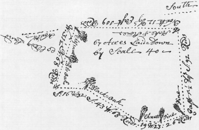
Laid out by the subscribers to Harvard Colledge sixty seven Acres of Land scituate in the Northerly Part of Townshend, beginning at a Chessnutt Tree in the Line of the School-land and Running West 31½ degrees North 32 Rods to a Black-Oak-Tree which is the most South-easterly corner of the land formerly laid out to said Harvard Colledg, and then by said land 36 Rodds to a Stake and Stones in the line of said Colledgland, which stake and stones is a corner of Abial Boyntons Fourth Division, Then by said Boyntons land S. 16 degrees W. 32 Rodds to a Black-Oak, Then S.43 degrees W. 68 Rodds to a Chessnutt, Then 19 degrees W. 23 Rodds to a Pitch-Pine which is a corner of said Boyntons Fourth Division, and his Meadow-lott, then W.42 degrees S. 26 Rodds by the Meadow-lotts to another Line, and from thence by common Land E. 5½ degrees S. 92 Rodds to a stake and stones at the corner of the School Land, from hence N.12 degrees E.109 Rodds by the School land to the corner first described. Allowance is made in this Lott for a Way Through the same when the Town shall think it Necessary.
Surveyed June the 13th 1739 John Stevens Surveyor.
|
William Lawrance |
|
|
|
Jasher Wyman |
Committee |
|
|
Amos Whitney |
Cambridge July 10 1739
Mr. Steward
Sir
Please to pay to Capt. William Lawrence of Groton four and forty shillings and 6d.
per Edward Holyoke, President
To Andrew Bordman, Steward
|
surveyors charge |
0–15–0 |
|
Making the Plan |
0– 3–0 |
|
and Recording |
0– 2–6 |
|
2 Committee Men |
1– 4–0 |
|
£2– 4–6 |
Lands Papers, Miscellaneous, 1. 44. There is a sketch-map at the top of the document.
1 Henry Gibbs (A.B. 1685) was the author of The Certain Blessedness of All Those Whose Sins Are Forgiven … Boston, 1721.
2 Judah Monis was baptized on March 27, 1722.
3 This may possibly refer to a controversy over support of two churches in Water-town, with Colman supporting Henry Gibbs (noted above). See Clayton H. Chapman, Life and Influence of Rev. Benjamin Colman, D.D., 1673–1747 (thesis, Boston University School of Theology, 1946–1947), p. 213 n.
4 Reverend Daniel Williams (d. 1716); see No. 162 for extract from his Will and No. 244 for further references by Hollis to it.
5 Reverend William Harris (1675?–1740); he was a trustee of Daniel Williams’s foundations.
6 Josiah Willard (A.B. 1698) was Secretary of the Province at this time.
7 Colman and John Jeffries were married to daughters of Thomas Clark.
8 There follows “An Extract from an Old Book of Records of the Overseers”. This is the same as preceding No. 33, and is not reprinted here.
9 May be translated: I have done these things, another has borne the honors. Thus we not for ourselves—.
10 This is a reference to College Book II, which was destroyed in the fire of 1764. Sever put quotation marks at the beginning of each line.
11 Leverett prepared a draft charter in 1723, but it was never presented. Parts of this letter relating to the proposed charter are quoted in Quincy, History, i. 258, 434; see also Hoffmann, Commonwealth College, pp. 443–450, and S. E. Morison, Three Centuries of Harvard, p. 72.
12 Benjamin Colman, Moses a Witness to our Lord and Saviour Jesus Christ … Before the Baptism of Judah Monis … Boston, 1722.
13 Judah Monis, “Three Discourses Written by Mr. Monis Himself, The Truth, the whole Truth, and, Nothing but the Truth,” Boston, 1722. Issued with Benjamin Colman’s piece, as above.
14 Thomas Burnet, The Theory of the Earth. The Two First Books, Concerning the Deluge, and Concerning Paradise. The 1723 Catalogus lists the third edition, London, 1697.
15 Over the next few years Hollis gave a number of books to the College; a few have been mentioned already. An attempt has been made to identify authors and titles, where possible. However, if an author’s last name only is given, or if a title of a voluminous author is listed in abbreviated fashion, further identification has, for the most part, not been provided. Long titles are abbreviated here, and it is noted if the title is listed in the printed Harvard Library catalogs, which start in 1723.
16 The Herbal by Parkinson and Burnet’s work have been mentioned in earlier letters.
17 Thomas Goodwin (1600–1680) wrote at least two expositions on Ephesians.
18 Nathaniel Grew (1641–1712), Cosmologia Sacra or, A Discourse of the Universe … London, 1701. Listed in the Supplement to the 1723 Catalogus.
19 Joseph Pyke, An Impartial View of the Principal Difficulties that Affect the Trinitarian … London, 1721.
20 John Goffe, Jesus Christ, the Very God … London, 1722.
21 John Guyse (1680–1761), Jesus Christ, God-Man, London, 1719, and The Holy Spirit a Divine Person … London, 1720.
22 John Gale (1680–1721), Reflections on Mr. Walls History of Infant Baptism, London, 1711. Listed, but without author, in the Supplement to the 1723 Catalogus. Many of these authors were Independent or Baptist ministers. Some of the titles were intended for individuals, and so are not to be found in the Library Catalogs.
23 The portrait, painted by Joseph Highmore, was lost in the burning of Harvard Hall in 1764. An engraving by Pelham exists; it shows Hollis at a table, reading a letter from John Leverett. After the fire, Hollis’s grandnephew sent a replacement, a portrait by Cipriana; the Corporation then commissioned Copley to make a likeness, based on the Cipriana portrait. In this, the letter shown is from Hollis to Leverett. See Laura M. Huntsinger, Harvard Portraits (Cambridge, 1936), and Early Science at Harvard, an account of an exhibit at the Fogg Museum, 1969, prepared by Louise Todd Ambler.
24 Benjamin Wadsworth, the future President of the College.
25 Edmund Quincy (A.B. 1722).
26 Reverend Henry Gibbs (A.B. 1685) died in 1723; for copy of this extract see CSM Publications, XVI. 852.
27 Capt. Ephraim Flynt also died in 1723; for copy of this extract see CSM Publications, XVI. 840–841.
28 Thomas Danforth, Deputy Governor and College Treasurer, died in 1699; however, it was not until 1724 that the Corporation officially learned of this bequest, from Francis Foxcroft, Executor. See CSM Publications, XV. XCV, and XVI. 515.
29 Mrs. Anne Mills died in 1725; for copy of this extract see CSM Publications, XVI. 841.
30 See No. 266 for identification of these authors.
31 Mrs. Susanna Condy, mother of Jeremiah (A.B. 1726); John Callender (A.B. 1723) and Samuel Mather (A.B. 1723) were also recipients of Hollis aid.
32 Timothy Cutler (A.B. 1701). See the following letter (No. 266) for further reference to Cutler, and a note about him.
33 This apparently refers to Increase Mather and Judah Monis.
34 Benjamin Colman, Practical Discourses upon the Parable of the Ten Virgins, London, 1707.
35 Timothy Cutler (A.B. 1701). At the Yale Commencement of 1722 Cutler, who had been appointed Rector in 1719, made the startling announcement that he planned to seek orders in the Church of England. His remarks to Hollis, as detailed here, are quoted in Quincy, History, i. 365. See Sibley, Sketches (Shipton), v. 49–55.
36 John Nesbit died on October 22, 1727.
37 Samuel Shute (1662–1742) came to Boston as Governor in 1716; he returned to England in 1723, and his commission was vacated in 1727.
38 John Owen (1616–1683) was a prolific writer on religious subjects; his name has been mentioned before. A volume of his Sermons and Tracts (London, 1721) appears in the Supplement to the 1723 Catalogus.
39 Sir Peter King (1669–1734) became Lord Chancellor in 1724/25. His work on the Apostles Creed was published in 1702, and that on the Primitive Church in 1691, with another edition in 1712. Both titles appear, without author, in the Supplement to the 1723 Catalogus.
40 James Peirce (1674–1726). His Vindication of the Dissenters (London, 1717) appears in the Supplement to the 1723 Catalogus.
41 David Clarkson (1622–1686); his work on Primitive Episcopacy appeared in London in 1688, and that on Liturgies in 1689. Both titles are in the Supplement to the 1723 Catalogus.
42 Probably John Collinges (1623–1690).
43 Joseph Morris, a Baptist minister; a second edition of his Sermon on the Death of Reverend R. Gould was issued in London in 1723.
44 John Hancock, Water the Best Cure for Febrifugum Magnum or Common Fevers … London, 1722, with further editions in 1723.
45 Wigglesworth was made a Fellow of the Corporation in 1723.
46 Samuel Penhallow, merchant of Portsmouth, N. H., and his son, Benjamin (A.B. 1723). Benjamin died of smallpox, possibly on this voyage to England. See Sibley, Sketches (Shipton), VII. 247.
47 Mather Byles (A.B. 1725), grandson of Increase Mather. The other two students have been mentioned earlier.
48 Elisha Callender (A.B. 1710), minister of the Baptist Church in Boston. His nephew, John Callender (A.B. 1723), was for a time Baptist minister in Swansea. See Sibley, Sketches (Shipton), VII. 150–151.
49 John Shute, first Viscount Barrington (1678–1734); he was a friend of Locke and Watts, and a member of Jeremiah Hunt’s Church. He and Samuel Shute, the Governor, were brothers.
50 Jeremiah Hunt (1678–1744), Independent minister.
51 This probably refers to addresses to King George. The Corporation adopted one, at its meeting on February 5, 1722/23, the occasion being the discovery of a conspiracy against the royal family. See CSM Publications, XVI. 480–482. This was sent to Hollis and Newman for presentation, but was apparently not received, and the Corporation adapted it in 1727 for an address to the new King. The United Ministers of Boston also addressed the King in the spring of 1723.
52 Possibly Colman’s Two Sermons Preached.… March 5, 7725 … Boston, 1723; if so, they reached England promptly.
53 Daniel Browne (Yale 1714.).
54 Possibly John Checkley (d. 1754), who was characterized in this way.
55 Grey Neville, who died on April 24, 1723. He left money to Reverend Jeremiah Hunt to preach a sermon on his death, but stipulated that he not be mentioned by name.
56 Samuel Johnson, Yale Tutor, who became an Episcopalian with Cutler. Cutler’s English Doctorate of Divinity was the first awarded to a Harvard graduate.
57 The Committee report is part of No. 256, and is omitted here.
58 This is an error for 1723.
59 Reverend Edmund Calamy (1671–1732), biographical historian of nonconformity.
60 Samuel Shute, who had served as Governor since 1716, left Massachusetts at the beginning of 1723.
61 Two subsequent pages are meant to be inserted at this place.
62 The manuscript here returns to page 14 of the original.
63 Benjamin Colman, David’s Dying Charge … A Sermon Preached … the Day for the Annual Election of his Majesty’s Council. Boston, 1723. There may have been other Election sermons.
64 The Overseers’ vote against Wigglesworth’s becoming a Fellow was part of the Sever-Welsteed controversy. In a few months that was settled, the Corporation reelected Wigglesworth, and the Overseers concurred.
65 See note to No. 285 for information on the proposed Charter.
66 For an account of Leverett’s draft of a charter see note to No. 258 and CSM Publications, xv. lxii; the draft is printed in CSM Publications, xxv. 390–400, edited by Albert Matthews.
67 William Whiston (1667–1752), A New Theory of the Earth … London, 1696; there were later editions in 1708, 1722, and 1725. The 1722 edition is listed in the Supplement (continuation) to the 1723 Catalogus.
68 Charles Chauncy (A.B. 1721), also noted earlier.
69 Nathaniel Appleton (A.B. 1712), was minister at Cambridge and son-in-law of Henry Gibbs; the latter died on October 21, 1723.
70 The Corporation voted, on December 25, 1723, that 100 copies of the Library Catalogue be sent to England, 30 for Mr. Hollis, 30 to Mr. Neal, 12 to Mr. Newman, 12 to Mr. Agent Dummer, 6 to Governor Shute, 6 to John Chamberlayne, and 4 to Mr. Loyd. See CSM Publications, xvi. 503. The Catalogue was prepared by Joshua Gee (A.B. 1717).
71 Benjamin Colman, The Prophet’s Death Lamented and. Improved, in: a Sermon Preached … to the North Church … on the Lords Day after the Funeral of their … Pastor, Increase Mather, D.D…. Boston, 1723.
72 Josiah Willard (A.B. 1698), Secretary of the Province.
73 Elisha Cooke (A.B. 1698). Cooke was sent to London as a kind of agent extra-ordinary by the patriot party; Jeremiah Dummer (A.B. 1699), the regular agent, was not pleased. Cooke brought with him his son, Middlecott (A.B. 1723). See Sibley, Sketches (Shipton), iv. 353.
74 Doubtless the anonymous letter.
75 Probably John Gale (1680–1721), Baptist minister; see note to No. 259. His Sermons on Several Subjects (2 vols., London, 1724) are noted in the Supplement (continuation) to the 1723 Catalogus.
76 The Corporation originally planned to send 100 catalogues to Hollis; the 4 intended for Mr. Loyd were omitted; see No. 288 preceding. Most of the persons named by Hollis were relatives or Dissenting ministers.
77 John Chamberlayne, some of whose writings (as well as those of his father, Edward) had been given to the Harvard college Library, died on November 2, 1723.
78 In the margin: “E H”.
79 Reverend Thomas Bradbury (1677–1759), Congregational minister of London.
80 Anyone using the catalogue notes this difficulty; entries are grouped under letters, but not alphabetized further.
81 Probably John Perkins (A.B. 1695); See Sibley, Sketches (Shipton), iv. 265.
82 William Dummer, Lt. Governor, was Jeremiah’s brother. The latter’s efforts on behalf of Yale College are described in Sibley, Sketches (Shipton), iv. 462–464.
83 Probably Edward Wigglesworth, Sober Remarks on … A Modest Proof … Boston, 1724. Benjamin Wadsworth’s A Dialogue … about the Lord’s Suffer … also appeared in 1724.
84 Thomas (d. 1735), son of Thomas, Sr.’s brother, Nathaniel.
85 Humphrey Prideaux, The Old and New Testament Connected; the 1720 edition is listed in the Supplement (Continuation) to the 1723 Catalogus.
86 Laurence Eachard, Ecclesiastical History; the edition of London, 1721, is recorded in the Supplement (Continuation) to the 1723 Catalogus.
87 Samuel Sewall (A.B. 1671).
88 “Liberal” is substituted for “learned”, crossed out.
89 No more than three words, not easily decipherable, are inserted above the line.
90 Probably Samuel Hirst (A.B. 1723). See Sibley, Sketches (Shipton), vii. 191, where it is suggested that he went to England on graduation. He was a grandson of Judge Samuel Sewall, and he died at the early age of twenty-one.
91 Hull Abbot (A.B. 1720). He had received Hollis aid as a graduate student, and on February 5, 1724 was ordained the colleague of the Reverend Simon Bradstreet of Charlestown.
92 Wigglesworth’s salary was increased, and he was made a Fellow; see No. 303.
93 Hollis is here trying to obtain from his ministerial friends copies of their publications. Among those mentioned are John Evans (1680?–1730), William Harris (1675?–1740), and Isaac Watts (1674–1748).
94 Benjamin Robinson (1666–1724), Presbyterian minister, died on April 30.
95 Robert Ashurst was Governor of the above Company from 1719 to 1726.
96 An old word for taxes or assessments.
97 President Leverett died on May 3, 1724.
98 Mather Byles (A.B. 1725) suffered from consumption the last half of his College years; see Sibley, Sketches (Shipton), vii. 4.67. However, he lived until 1788.
99 The listing of the Joseph Hussey donation constitutes the next document, No. 306. Professor Wigglesworth was directed to write the Latin letter to Mr. Hussey; CSM Publications, xvi. 516.
100 For identification of these titles see note to No. 323.
101 Herewith a note on the volumes, in alphabetical order, with an indication as to whether they are listed in the Supplements to the 1723 Catalogus.
- Cheselden, William; this title (London, 1723) is noted in the Supplement (Continuation).
- Martin, Isaac, The Tryals and Sufferings … (London, 1723), noted in the Supplement (Continuation).
- Mather, Samuel, A Vindication of the Holy Bible … (London, 1723), noted in the Supplement (Continuation).
- Owen, John, Work of the Spirit in Prayer (London, 1682) and Meditations and. Discourses of the Glory of Christ … (London, 1696) are both listed in the Supplement (Continuation).
102 Samuel Chandler (1693–1766) was a nonconformist divine and bookseller. Books in this lot from John Hollis are listed alphabetically by author, with identification of author and title, where possible. In this and subsequent lists of books sent to the Harvard Library indication of listing in the printed supplements to the Catalogus of 1723 is noted thus: S, first Supplement; SC, Supplement (Continuation), to 1725; 1735S, Supplement, issued in 1735.
- Bayles, Pierre, Dictionnaire Historique et Critique … Troisième Édition, 4 vols., Rotterdam, 1720, SC. For later comment by Hollis on this title see No. 313.
- Bèze, Théodore de; this title is listed in SC as Testamentum, 1598, and has not been further identified.
- Cyprian, Saint, Bishop of Carthage, Opera, Recognita et Illustrata per Joannem Fell; the edition noted in SC is Amsterdam, 1700.
- Cotelerius, Joannes Baptista; not noted in Supplements to Catalogus; editions of his Works (Opera), in two volumes, were issued in 1672, 1698, and 1724.
- Eusebius, Pamphili, Ecclesiasticae Historiae, 3 vols., Cambridge, 1720, SC; Same, Evangelica Preparatio and Evangelica Demonstratio, Paris, 1628, SC.
- Grabe, Johann Ernst, Vetus Testamentum … Septuaginta, 1707.
- Gregory, Saint, Bishop of Neocaesarea, Thaumaturgi, Macarii … et Basilii … Paris, 1622, SC.
- Irenaeus, Saint, Bishop of Lyons, Contra Omnes Haereses … cum Notis Joan Ernesti Grabe, Oxford, 1702, SC.
- Mill, John, Testamentum Graecum cum Lectionibus Variantibus, Edit. 2, per Lud. Kusterum, Leipzig, 1723, SC.
- Spencer, John, Dean of Ely, De Legibus Hebraeorum, 2d ed., Gravenhage (S’), 1686, SC.
- Tertullian, Opera cum Annotationibus Integris … Nic. Rigalti, Lyon, 1675, SC.
- Tromm, Abraham, Concordantiae Graecae, 2 vols., Amsterdam, 1718, SC.
103 Possibly Thomas Cox (d. 1734), topographer and translator. The books in this lot are listed alphabetically in the same way as the lot above:
- Bochart, Samuel, Opera Omnia; Hoc Est, Phaleg, Chanaan et Hierozoicon … 4th ed., 3 vols., Leiden, 1712, SC.
- Browne, Simon, The Charge of Schism against the Dissenters Discharg’d, in Reply to a Tract of the Reverend Mr. Norris, London, 1710.
- Ellies-Dupin, Louis, A New History of Ecclesiastical Writers, translated by W. Wotton, 2d ed., 7 vols., London, 1693–1706, SC. A volume covering the seventeenth century (Oxford, 1725) is listed in 1735S.
- Henry, Matthew, A Brief Enquiry into the True Nature of Schism; there were editions in 1690 and 1719.
- Lightfoot, John, The Works of … 2 vols., London, 1684, SC.
- Locke, John, The Works of … , 2d ed., 3 vols., London, 1722, SC.
- Montfaucon, Bernard De, Antiquity Explained and Represented in Sculptures, Englished by David Humphreys, 5 vols., London, 1721–1722 (1725), SC.
- Moore, Honesty of Dissenters; not further identified.
- Pyle, Thomas, A Paraphrase: vols. 1–2, on Pentateuch, London, 1717; vols. 1–2, on Acts … London, 1715, SC.
- Vossius, Gerardus J., Opera, 6 vols., Amsterdam, 1695–1701, SC.
- Whitby, Daniel, Paraphrase and Comment on the New-Testament, 2 vols., London, 1718?, SC.
Moore, Henry, and Browne, being slight, were evidently not added to the Library.
104 The following listing gives additional identification of some of the authors and titles; arrangement is alphabetical. Abbreviations indicating listing in the printed Library catalogues are as before: S, first Supplement; SC, Supplement (Continuation), to 1725; 1735S, Supplement, 1725–1735.
- Alabaster, Gulielmus, Ecco Sponsus Venit, London, 1633, SC.
- Alfred, Henry, De Manducatione … Geneva, 1630; not further identified.
- Angelocrator, Daniel, known as Engelhart, Daniel, De Ratione Temforum et Rerum ab Initio Mundi Usq. ad Rudolphum II Rom. Imferatorem Libri Novem, Frankfurt, 1660, SC.
- Brownrigg, Ralph, Bishop of Exeter, Sixty-five Sermons, London, 1691, SC. Listed in the British Museum Catalogue as 2 vols., 1685.
- Chauncy, Isaac, An Essay to the Interpretation of the Angel Gabriel’s Prophesy Deliver’d by the Prophet Daniel … London, 1699, SC.
- Chemnitius, Martin, Loci Theologici … Frankfurt-am-Main and Wittenberg, 1690, SC. The British Museum Catalogue lists editions in 1604 and 1653.
- Corbet, John, Kingdom of God Among Men, London, 1679, SC.
- Crowe, William, Elenchus Seriptorum in Sacram Seripturam … London, 1672, SC.
- Damian, James, Synopsis Primi Seculi Societ. Jesu, Tournay, 1641, SC; not further identified.
- Dickson, David, Therapeutica Sacra, London, 1656, SC.
- Goodwin, Thomas, Fifth Volume of Discourses, London, 1704.
- Gray, Andrew, The Mystery of Faith Opened Up, Edinburgh, 1693, SC.
- Helvicus, Martin; see Klein below.
- Highmore, Nathaniel, Corporis Humani Disquisitio Anatomica, Gravenhage (S’), 1651, SC.
- Hughes, John, Essay on Christ’s Divinity, London, 1712, SC.
- Hussey, Joseph, A Warning from the Winds, London, 1704, SC; the other titles are not listed. This man is the donor of the collection.
- Jermyn, John; not further identified.
- Klein, Michael J., Hoc Est Diatribe de 70 Hebdomadibus Danielis, Gissen, 1624;
- Martin Helvicus presided over this dissertation. For another interpretation of Daniel see Chauncy above.
- La Haye, Jean de, Commentarii Literales et Conceptuales in Exodum … Paris. Bibliothèque Nationale Catalogue has date 1638.
- Lopez, R. P., Societ. Jesu, De Authoritate Scripturae, Seville, 1588, SC.
- Lycosthenis, Conrad, Apothegmatum … ,1594, SC; there was a 1574 edition in Lyon.
- Maccovii, Joh., Opuscula Philosophica, Amsterdam, 1660, SC.
- Marbury, Edward, A Brief Commentary … upon Obadiah … London, 1649.
- Margirus, Joannes, Physiologiae, Cambridge, 1642.
- Otes, Samuel, An Explanation of the … Epistle of Saint Jude, London, 1633, SC.
- Quistorp, Johan. Comment. Analiticus in utramque S. Apostoli Pauli ad Timotheum … Rostock, 1637, SC.
- Ray, John, The Ornithology of F. Willughby … London, 1678.
- Robinson, Benjamin, A Review of the Case of Liturgies and Their Imposition, in Answer to Mr. Bennet’s Brief History of Precomposed Set Forms of Prayer, London, 1710, S.
- Romei, Nicholas (so SC), Effigies Calvini Nova Centum Coloribus ad Vivum Expressa, Antwerp, 1622.
- Shepheard, Thomas. The first two titles are listed in SC; more correct titles would be: Theses Sabbatica or the Doctrine of the Sabbath; Certain Select Cases Resolved.
- Sibbes, Richard, The Saints Cordials … London, 1629, SC.
- Sibelius, Caspar, Commentarius in Psalmum 16, Amsterdam, 1635.
- Stapulensis, James, or d’Étaples, Jacques, or LeFevre, Jacobus Faber, Commentarii Initiatorii in Quatuor Evangelia … SC. The British Museum Catalogue gives the date as 1522.
- Stierius, Joannes, Praecepta Doctrinae Logicae … 1659, SC. The British Museum Catalogue has date of 1652.
- Streso, Casparus, Commentarius Practicus in Actorum Apostolicorum, Amsterdam, 1650, SC. Same, Condones Quaedam Miscellaneae, Amsterdam?, 1654, SC. The British Museum Catalogue has an edition issued at Gravenhage (S’), 1641.
- Taylor, Jeremiah, Bishop. These titles are grouped in SC as Prophecying, Prayer ex Tempore, Episcopacy, etc., London, 1647. The British Museum Catalogue lists Treatises of, 1–4, London, 1648.
- Tong, William, A Funeral Sermon Preached at Hackney … Death of Matthew Henry … London, 1716, SC. The British Museum Catalogue has date of 1714.
- Tully, Thomas, Dean of Ripon, Justisicatio Paulina, Oxford, 1674, SC.
- Viccars, John, Decupla in Psalmos, London, 1639, SC. The British Museum Catalogue has date of 1655.
105 Joseph Sewall (A.B. 1707) was chosen President by the Corporation on August 11, 1724, but the Old South Church, of which he was Pastor, declined to release him. Hollis evidently had advance information about the possibility of his selection. A house was built later for the new President.
106 See No. 305 for notice of a few books from Hollis, and a larger number from his brother, John.
107 The Reverends Appleton, Wadsworth, and Colman all preached sermons on Leverett’s death, and Tutor Welsteed gave the funeral address.
108 Noted in the Supplement (Continuation) to the 1723 Catalogus is Sermons on Various Subjects (2 vols., London, 1721), by Isaac Watts.
109 Samuel Mather (A.B. 1690), Congregational minister of Witney, England. His Memoirs of the Life of … Increase Mather … appeared anonymously in London in 1725. It is listed in the Supplement (Continuation) to the 1723 Catalogus, and is dated 1724.
110 Probably Reverend Thomas Bradbury, already noted. He took part in a pamphlet war, writing, among other titles, A Letter to John Barrington Shute, Esq. (1720).
111 William Bratde (A.B. 1680), Treasurer, 1713–1715.
112 Francis Foxcroft (A.B. 1712).
113 Thomas Foxcroft (A.B. 1714.).
114 John Sparhawk (A.B. 1724), a great-grandson of Thomas Danforth.
115 John Robinson.
116 John Hubbard.
117 William Paine; he rented the house given by H. Webb.
118 John Swan; see CSM Publications, xvi. 547, 610, 677.
119 Isaac Lobdell.
120 Samuel Moody (A.B. 1689); the Corporation on September 6, 1717, asked “Capt. Moodey” to make secure these lands; CSM Publications, xvi. 437.
121 Direction to sell this land was given by the Corporation in 1716; it was not accomplished until five years later; CSM Publications, xvi. 436, 457.
122 The list of books duplicate the invoice of Box No. 5, in No. 315 following, so it is not repeated here. They constitude the first 26 titles, or those given by William Wooly of Clapton in Hackey and Edward Leeds himself.
123 Hollis’s wife died on December 8; see his letter of January 6 to Colman.
124 According to the Supplement (Continuation) to the 1723 Catalogus the College Library contained Pier Bayle, Dictionaire Historique et Critique, 4. vols., Rotterdam, 1720. Hollis refers to this again in his letter of January 6 to Colman, and Quincy mentions it in his History, 1. 433.
125 Dr. Zabdiel Boylston, well known for his early inoculating of Bostonians against smallpox.
126 The Corporation chose Colman President on November 18, 1724, but he declined, feeling that his unpopularity with the Lower House would affect the College’s fortunes.
127 There were two early additions to the 1723 Catalogus; they were: Supplementum, numbering pages 100 to 102, and carrying titles to 1722; and Continuatio Supplementi numbering pages 103 to 112, and carrying entries to 1724.
128 Thomas Guy died on December 27, 1724; he founded Guy’s Hospital.
129 The students were: John Lovell (A.B. 1728), Jedidiah Jewett (A.B. 1726), and Daniel Brewer (A.B. 1727); the last-named was a great-grandson of President Chauncy.
130 See note to No. 312 about the French Dictionary.
131 Bernard De Montfaucon, Antiquity Explained and Represented in Sculptures, Englished by David Humphreys, 5 vols., London, 1721–1725; listed in the Supplement (Continuation) to the 1723 Catalogus, as London, 1721–1722.
132 Adam Winthrop (A.B. 1694); for his work with the Indians see Sibley, Sketches (Shipton), iv. 213.
133 See No. 300 for letter from Hollis to John Gunston.
134 This gift is noted further in No. 315.
135 The books are listed herewith alphabetically by author. Indications of entry in the printed catalogues of the Library are as before: S, first Supplement, SC, Supplement (Continuation), to 1725; 1735S, Supplement, 1725–1735.
- Assembly’s Confession of Faith … with the Larger and Shorter Catechisms, London, 1717, SC.
- Avery, Benjamin, contributor to Occasional Papers, 3 vols., London, 1716–1719, SC. This was the case where Hollis thought the author wanted to remain anonymous; he was also a donor of books.
- Bangor, Bishop of, Common Rights; not further identified.
- Barlow, Edward, An Exact Survey of the Tide, 2 vols., London, 1717, SC. There was a second edition in 1722.
- Barrow, Isaac, Works, 2 vols., London, 1722, SC. The British Museum Catalogue lists the 1722 edition as in 3 volumes.
- Bates, William, Works, 2d ed., 1723, SC.
- Baxter, Richard, The Practical Works … 4. vols., London, 1707, 1723 Catalogus. An abridgement of this work by E. Calamy in 2 volumes was published in London in 1713 (2d edition).
- Browne, Simon, Sermons on Several Subjects, London, 1722, SC.
- Burkitt, William, Expository Notes … on the New Testament, London, 1712, SC. There were several editions to 1724.
- Burnet, Gilbert, Bishop of Salisbury, A Discourse of the Pastoral Care, London, 1692, SC.
- Burnet, Thomas, A Essay upon Government or, The Natural Notions of Government Demonstrated … London, 1716, SC.
- Clarke, Samuel, The True Scripture Doctrine of the Holy Trinity, London, 1719, SC. The British Museum Catalogue lists an edition of 1713.
- Cocceius, Joannes, Summa Theologia ex Seripturis Repetita, Amsterdam, 1665, SC. The Bibliothèque Nationale lists an edition, Leiden, 1662.
- Collier, Jeremy, The Great Historical, Geographical, Genealogical, and Practical Dictionary. The British Museum Catalogue lists a second edition, in 2 volumes, London, 1701.
- Critical History of England, Ecclesiastical and Civil, London, 1724, SC. The British Museum Catalogue identifies as by John Oldmixon.
- Cromwell’s Life; probably The Life of Oliver Cromwell, by I. Kimber, London, 1724, SC. There were several editions.
- Davenant, John, Bishop of Salisbury (probable); SC lists De Praedestinatione et Reprobatione, Cambridge, 1650.
- Dickson, David, Therapeutica Sacra, London, 1656, SC.; also noted in No. 306.
- Disney, Daniel, The Portion of God’s People … London, 1715, SC.
- Doolittle, Thomas, A Complete Body of Practical Divinity, London, 1723, SC.
- Evans, John, Sermons on the Christian Temper, 2 vols., London, 1723, SC.
- Flavel, John, The Whole Works of …, 2 vols., London, 1716, SC.
- Gouge, Thomas, The Works of … London, 1706, SC.
- Greek and Roman Antiquities; these were sets by Graevius and Gronovius; they are noted in No. 305.
- Grosvenor, Benjamin, Health, an Essay on … London, 1716, SC. Same, Two Discourses; First, on the Name of Jesus; Second, the Temper of Jesus, London, 1724, SC.
- Gurnal, William, The Christian in Compleat Armour, London, 1699, SC. The first edition appeared in 1655.
- Guyse, John, Jesus Christ God-Man, or the Constitution of Christ’s Person, 3 vols., London, 1719–1724, SC.
- Hall, Joseph, Bishop, Contemplations on the Life of Jesus, London, 1679, SC.
- Harris, William, Practical Discourses on the Principal Representations of the Messiah Throughout the Old Testament, London, 1724, SC.
- Henry, Matthew, Expositions on the Bible, 6 vols., London, 1721 (?), SC. This author issued a number of Biblical Expositions.
- Hopkins, Ezekiel, Bishop of Raphoe and of Derry, Works, 3d ed., London, 1710, SC.
- How, John, The Works of …, 2 vols., London, 1724, SC and 1735S.
- Kidder, Richard, Bishop of Bath and Wells, A Commentary on the Five Books of Moses, 2 vols., London, 1694, SC.
- Manton, Thomas, Sermons on the 119th Psalm, London, 1681, SC. Same, Fifth Volume of Sermons, London, 1701, SC.
- Masters, Thomas, Instruction and Diligence the True Way to the Knowledge of the Scriptures, London, 1724. This was designated “for Mr. Callender”, and it does not appear in the Library Catalogue.
- Mather, Samuel, Memoirs of the Life of … Increase Mather, London, 1724, SC.
- Mir Wais, Muhammad (appears also as Niri-Weys or Mizeweis), The Persian Cromwell, London, 1724, SC.
- Muis, Simeon De, Commentarius in Omnes Psalmos …
- Potter, John, Archaeologia Graeca, or the Antiquities of Greece, 2 vols., Oxford, 1697–1699, SC.
- Ray, John, A Collection of English Proverbs … 2d ed., Cambridge, 1678, SC.
- Reynolds, John, Three Letters to the Deists, London, 1725, SC.
- Russian Catechism; probably The Russian Catechism, Composed and Published by Order of the Czar, Translated by J. T. Phillips, London, 1723.
- Sedgwick, Obadiah, The Bowels of Tender Mercy Sealed in the Everlasting Covenant … London, 1661, SC.
- Servetus, Michael, probably An Impartial History of Michael Servetus … London, 1724.
- Strothers, Edward, An Essay on Sickness and Health, London, 1725, SC.
- Tillotson, John, Archbishop of Canterbury, Works, 3 vols., London, 1720, 1722, SC. The British Museum Catalogue lists a three-volume edition in 1728.
- Varenius, Bernardus, Geographia Generalis, Cambridge, 1672, SC. The British Museum Catalogue lists a 1681 edition.
- Vertot, Aubert De (also known as Rene D’Aubeuf), The History of the Revolution That Haffened in the Government of the Roman Refublic … English’d by Mr. Ozell and Others, 3d ed., 2 vols., London, 1723–1724, SC.
- Watts, Isaac, Sermons on Various Subjects, 2 vols., London, 1723, SC.
- Wilkins, John, Bishop of Chester, A Discourse concerning the Gift of Prayer … also, Ecclesiastes, or, A Discourse concerning the Gift of Preaching … London, 1724, SC.
- Witsius, Herman, De Occonomia Foederum Dei cum Hominibus … Leeuwarden, 1677, SC.
- Wollaston, William, The Religion of Nature Delineated, London, 1725, SC.
- Wright, Samuel, A Treatise on the Religious Observance of the Lord’s Day, London, 1724, SC.
136 The Corporation voted acknowledgment to Mr. John Loyd for these works by Graevius and Grenovius, although he was apparently not the actual donor. CSM Publications, xvi. 521.
137 The Corporation asked Mr. Colman to thank “Mr. John Guise Minister of Hertford in Great Britain” for these copies of his works. CSM Publications, xvi. 520.
138 Thomas Cotton (1653–1730); see Quincy, History, i. 402 and 427–428. Cotton’s wife was a daughter of President Hoar.
139 These witnesses were: Tutor Prince (A.B. 1718) and Librarian Hancock (A.B. 1719).
140 The 1735 Supplement to the 1723 Catalogus lists the Histoire de L’Academie Royale Des Sciences, 1699–1718, 28 vols., Paris, 1718–1721, and 1719–1730, 12 vols., Paris, 1721–1732. Volumes to the number of 25 may have been received shortly after this letter was written.
141 Robert Boyle (1627–1691) founded the Boyle Lectures for Defence of Christianity against Unbelievers; the 1735 Catalogue Supplement notes lectures on his foundation by several Independent Divines.
142 James FitzGerald (A.B. 1723).
143 Joseph Marsh (A.B. 1728).
144 James Chandler (A.B. 1728), entered College from Andover.
145 Phillips (A.B. 1708) was minister of Andover.
146 Isaac Greenwood (A.B. 1721), who was to fill the Hollis Chair of Mathematics at Harvard.
147 Josiah Smith (A.B. 1725); for his father’s connection with Bermuda see Sibley, Sketches (Shipton), vii. 570.
148 Richard Solly, mentioned in earlier letters.
149 Cotton Mather (A.B. 1678); he died three years later, never realizing his wish to become Harvard’s President.
150 Could this be a hint of an idea which more than two centuries later developed into the New England Deposit Library?
151 Possibly Wadsworth’s It’s Honourable, not Shameful, to Suffer for Christ… Boston, 1725.
152 Johannes Georgius Graevius, Thesaurus Antiquitatum Romanarum, and Jacobus Gronovius, Thesaurus Graecarum Antiquitatum; both are listed in the Supplement (Continuation).
153 William Welsteed (A.B. 1716) was still a Tutor. Hollis may have referred to his father, also William, a prominent Boston merchant.
154 This phrase is in the same hand as Sewall’s signature.
155 Benjamin Wadsworth (A.B. 1690); minister of the First Church, Boston; he had served continuously on the Corporation of the College since 1712. He was a compromise candidate for the presidency, after both Joseph Sewall and Benjamin Colman declined.
156 John Shute, First Viscount Barrington, Miscellanea Sacra, 2 vols., London, 1725. This title is listed in the 1735 Catalogue Supplement, but without the author’s name.
157 Substituted for PS crossed out. The Dictionary of National Biography states that Benjamin Avery contributed to Occasional Papers, 3 vols., London, 1716–1719. The title is listed under Avery, with no first names, in the Supplement (Continuation) to the 1723 Catalogus.
158 In the end Reverend Thomas Cotton allocated £100 to augment the President’s salary and £300 for purchase of books. See CSM, Publications, xvi. 841–842, and Quincy, History, i. 401–403.
159 Nicholas Sever (A.B. 1701) was finally made a Fellow of the Corporation on September 13, 1725.
160 Jonathan Belcher (A.B. 1699), Boston merchant, and later Governor of both Massachusetts and New Jersey.
161 Colman tried to resign in 1728, but his resignation was not accepted. He finally left the Corporation at the end of 1729, but he continued as an Overseer by virtue of his position as minister of a Boston Church.
162 See note to No. 326.
163 Possibly Reverend Thomas Bradbury.
164 Joshua (not Joseph) Wood (A.B. 1727).
165 The Corporation voted acknowledgment of receipt of the type, to the value of £39, on April 4, 1726. See CSM Publications, xvi. 535.
166 Probably William Williams (A.B. 1705), minister of Weston. Another William Williams (A.B. 1683), minister of Hatfield, was still living.
167 Mary, daughter of John Gunston and second wife of Lord Mayor Sir Thomas Abny.
168 Samuel Gerrish and Bartholomew Green were both concerned with printing and distribution of the 1723 Catalogus.
169 Wigglesworth married Sarah Leverett, the late President’s daughter, on June 15, 1726.
170 John Eames (d. 1744), F.R.S., Dissenting tutor in the classics and in science.
171 Samuel Greenwood (A.B. 1709). Portions of this letter relating to Isaac Green-wood are quoted in Sibley, Sketches (Shipton), vi. 474.
172 William Cheselden, The Anatomy of the Humane Body, first published in 1713, with a second edition in 1722, and a third in 1726.
173 This was the bookseller-author-minister; see footnote to No. 305. The 1735 Catalogue-Supplement lists his Vindication of the Christian Religion (London, 1725), which was an answer to A. Collins.
174 Robert Ashurst, Governor of the Society for the Propagation of the Gospel in New England (the New England Company).
175 John Sheffield died on January 24, 1726.
176 The books included in this lot are:
Greene, John, Letters to the Author of the Discourse (A. Collins), London, 1726.
Selden, Johannis, Opera Omnia, London, 1726; this was noted in the 1735 Catalogue-Supplement.
I have not tried to identify the Life of Sir Thomas More or the Dissertation on Baptism.
177 Maker of iron.
178 Words, which appear to be “any Wast or Demolishment” are here crossed out.
179 On April 4, 1726 the Corporation voted that “Willard’s Lectures on the Assemblie’s Catechisme” (Samuel Willard, A Comfleat Body of Divinity in Two Hundred and Fifty Expository Lectures on the Assembly’s Shorter Catechism… Boston, 1726), “bound in the best manner”, be sent to Hollis as “a mite of acknowledgment”. CSM Publications, xvi. 536.
180 Probably Andrew Oliver (A.B. 1724.).
181 Ebenezer Turrell (A.B. 1721) married Jane Colman on August 11, 1726. Turrell later wrote a biography of his father-in-law.
182 Possibly Thomas Pierpont (A.B. 1721), who was a classmate of Greenwood’s.
183 Dr. John T. Desaguliers (1683–1744), natural philosopher.
184 Dr. Richard Mead (1673–1754), physician and book collector. On November 14, 1726 the Corporation voted that Mr. Colman should write a letter of thanks to Dr. Mead; see CSM Publications, xvi. 545.
185 A few lines of this letter are quoted in Sibley, Sketches (Shipton), vi. 474–475.
186 The new Governor of the Society was William Thompson.
187 Joseph Talcott, Governor of Connecticut from 1723 to 1741.
188 Probably Thomas Shelton, who published books on shorthand in the seventeenth century; he was a Puritan.
189 Daniel Dolings became a member of S.P.G.N.E. in 1709.
190 Joseph Mayhew (A.B. 1730). Hollis aid was not granted to him as a Freshman; see Sibley, Sketches (Shipton), viii. 730–731.
191 Experience Mayhew (M.A. 1723), Indian Converts … London, 1727.
192 Ebenezer Pemberton (A.B. 1691), Sermons and Discourses London, 1727.
193 Burnet, Thomas, Sermons at Mr. Boyle’s Lectures, 2 vols., London, 1726. The 1735 Catalogue-Supplement lists a number of Robert Boyle lectures by different persons.
194 Cotton Mather, Manuductio ad Ministerium … Directions for a Candidate of the Ministry … Boston, 1726.
195 Reverend Henry Harris, Assistant at King’s Chapel.
196 Reverend Samuel Myles (A.B. 1684), Minister of Kings’ Chapel, who later joined Cutler in his petitions about membership on the Overseers.
197 This should be Hobson throughout.
198 Samuel Penhallow, author of The History of the Wars of New-England with the Eastern Indians (Boston, 1726) died on December 2, 1726. His son, Benjamin (A.B. 1723) died of smallpox on a voyage to England in 1725.
199 Josiah Smith (A.B. 1725).
200 Joseph Hussey; for a list of his donation of books see No. 306.
201 John Ward (1676?–1758); he became a professor at Gresham in 1720. A later Thomas Hollis presented his portrait to the British Museum.
202 Possibly Richard Carr (1651–1706), who studied at Leyden and received an M.D. at Cambridge in 1686.
203 Joseph Standen, former Dissenting minister, then minister of Established Church at Speen, near Newbury.
204 Ebenezer Miller (A.B. 1722). Hollis’s later comment about his marriage is quoted in Sibley, Sketches (Shipton), vii. 95.
205 Probably Daniel Mayo (1672?–1733), a Presbyterian minister.
206 Reverend George Berkeley, Bishop of Cloyne (1685–1753); although interested in founding a college in Bermuda, he did present some books to Harvard, and was entertained at dinner in the Library in 1731.
207 Thomas Prince (A.B. 1707); this statement is quoted in Quincy, History, i. 528.
208 William Pennoyer’s bequest of funds for a scholarship came to the College in 1670.
209 The word “that”, in this and the following clause, has been written over “yet”, crossed out.
210 The witnesses were all related to Hollis.
211 I Kings, 12, 7: And they spake unto him, saying, If thou wilt be a servant unto this people this day, and wilt serve them, and answer them, and speak good words to them, they will be thy servants for ever.
212 “N.E. in …” these letters have been torn off and are added above.
213 David Parsons (A.B. 1729). Hollis recalled an earlier Joseph. These lines are quoted in Sibley, Sketches (Shipton), viii. 611.
214 Professor Greenwood was directed in 1728 to exhibit a catalogue of the apparatus received from Hollis; see CSM Publications, xvi. 570.
215 Josiah Smith (A.B. 1725); he and his father moved the family to the vicinity of Charleston, South Carolina, early in 1726/27; see Sibley Sketches (Shipton), vii. 571.
216 Abraham Hill (d. 1746).
217 Gershom Swan (d. 1752).
218 Wadsworth House, which is still standing, was sufficiently finished by November, 1726, that the President and his family could move in.
219 John Callender (A.B. 1723); this paragraph is quoted in Sibley, Sketches (Shipton), vii. 150.
220 In 1727 Timothy Cutler (A.B. 1701), minister of Christ Church, Boston, applied for membership on the Board of Overseers. This was denied, and the resulting controversy will be met with again in this volume.
221 William Harris succeeded William Tong, Presbyterian divine, who died on March 21, 1727.
222 Probably John Gale (1680–1721), Sermons Preached upon Several Subjects, 2d ed., London, 1726.
223 Several words are here crossed out and in the line below.
224 Edmund Calamy, Continuation of the Account of the Ministers … Who Were Ejected, and Silenced after the Restoration, 2 vols., London, 1727. Same, An Abridgement of Mr. Baxter’s History of His Life and Times, 2d ed., 2 vols., London, 1713.
225 Nathaniel Lardner (1684–1768), The Credibility of the Gospel History, 2 vols., London, 1727. Lardner married Daniel Neal’s sister, Elizabeth.
226 Quincy prints a good portion of the address (History, 1. 383–384), and states that it was adapted from an address prepared for an earlier occasion. He also quotes (p. 385) from this letter of Hollis about the quaintness of the address.
227 Isaac Greenwood (A.B. 1721) was elected Professor by the Corporation May 12, 1727; confirmed by the Overseers, May 25, 1727; and was installed February 13, 1728.
228 See note 8, No. 329.
229 John Simson (1668?–1740), controversial Scottish theologian; his account of his difficulties with the Assembly was published as Continuations, Edinburgh, 1727–1729.
230 In the following list the few abbreviated first names have been expanded.
231 John Avery (A.B. 1759) was the first Secretary of the Commonwealth of Massachusetts.
232 Christopher Bridge (A.B. 1733).
233 Thomas Tufts (A.B. 1732).
234 Samuel Danforth (A.B. 1715); this assignment of money to him is noted in Sibley, Sketches (Shipton), vi. 81.
235 A draft of an address to King George II was read at a Corporation meeting on September 7, 1727; see CSM Publications, xv. 555–557, where the text is also printed. It is also discussed, and parts quoted, in Quincy, History, i. 382–385.
236 Belcher Hancock (A.B. 1727).
237 Solomon Prentice (A.B. 1727); Thomas Prentice (A.B. 1726) was a Hopkins Scholar in 1728–1729.
238 Joshua Wood (A.B. 1727).
239 This could be either Stephen or William Fessenden, cousins, both graduates in 1737, and both residents of Cambridge in their youth.
240 Ammi Ruhamah Cutter (A.B. 1725).
241 Penn Townsend died in 1727, and Cotton Mather in 1728.
242 This was Elisha Callender (A.B. 1710); see Sibley, Sketches (Shipton), v. 514, where it is stated that Callender attended two meetings of the Overseers.
243 Matthew Sutcliffe: a title in English, A Treatise of Ecclesiastical Discipline was issued in London in 1591.
244 Mary Saltonstall was the widow of Gurdon Saltonstall; a copy of this extract is in CSM Publications, xvi. 845.
245 Samuel Browne (d. 1731); a copy of this extract is in CSM Publications, xvi. 846–847.
246 Dorothy Saltonstall, wife of Nathaniel Saltonstall; previously married to John Frizell, who died in 1723.
247 Hollis wrote to President Wadsworth on September 18, 1728; the letter has not been located. See No. 97 for an extract from it, relating to Robert Thorner’s bequest. Hollis also wrote to Colman on February 12, 1728/29; the letter is in the Colman Papers at the Massachusetts Historical Society. In it, Hollis writes of the Governor’s salary disputes, sends a Bible to James Stone (A.B. 1724), minister of Holliston, and mentions a visit from Messrs. Sewall and Arnold, of New Haven. He says he has written to Byles (Mather, A.B. 1725), and is glad the young man has regained his strength, but that he needs humility. He notes letters from Thomas Foxcroft (A.B. 1714), Samuel Mather (A.B. 1723), and Edward Wigglesworth, who sent a copy of a sermon of his brother, Samuel (A.B. 1707). He also acknowledges receipts of Colman’s essay on family worship; this was doubtless An Argument for and. Persuasive unto the Great and Important Duty of Family Worship, Boston, 1728.
248 Joshua Oldfield died on November 8, 1729.
249 Sarah Leverett Wigglesworth died on November 9, 1727, and on September 10, 1729, he married Rebecca, the daughter of Deacon Joseph Coolidge of Cambridge.
250 Joseph Dodson’s Twelve Discourses … was published in London in 1728.
251 The William Burgis Plan of Boston was issued in 1729; the John Bonner Map (1722) was also reissued in 1729.
252 William Burnet was Governor of Massachusetts in 1728 and 1729.
253 Jonathan Belcher (A.B. 1699) was appointed Governor on November 27, 1729. His son, Andrew (A.B. 1724.) was in England with him at this time.
254 Wigglesworth’s marriage is noted in No. 365. Isaac Greenwood married Sarah Clark on July 31, 1729.
255 John Asty died on January 20, 1729/30. Hollis has mentioned Joshua Oldfield, Edmund Calamy, Thomas Bradbury previously.
256 Samuel Chandler and John Guyse, authors whose works Hollis had sent to the College Library.
257 John Oldmixon, History of England during the Reign of the Royal House of Stuart, London, 1730; noticed in 1735 Catalogue-Supplement.
258 In error for Purrington.
259 Samuel Moody (A.B. 1689).
260 See the following item, No. 370.
261 Probably Benjamin Marston (A.B. 1715).
262 Thomas Danforth was President of the Province of Maine at this time.
263 Samuel Moody (A.B. 1689).
264 Higginson (A.B. 1717) served as Town Clerk of Salem, until his defeat in 1741. Sibley, Sketches (Shipton), vi. 196. Wadsworth’s wife, Ruth Bordman, was aunt to Higginson’s wife, of the same name.
265 See No. 87 for these instructions.
266 This sentence is added here: Blany’s deed says Purchase had a Patent from Council of Plymouth and Way’s deed says this Patent was to Way and Purchase. It appears not, that Blany had any power to sell.
267 Flynt’s cousin, Francis Willett, landowner and Judge in the Narragansett area. He was also known as Colonel, and a designation, which might be transcribed as “cor” or “coz”, is, when applied to him, given as “Col.”.
268 Thomas Hollis, Sr. died on January 22, 1730/31. Two of his last letters to Colman, not printed here, are in the Colman Papers, Massachusetts Historical Society. One, dated October 8, 1730, mentions a gift of books for the College Library from Dr. Watts. The other, dated October 22, 1730, notes with approval a letter from President Wadsworth, nominating four students for Hollis aid.
269 Colman’s sermon was: The Friend of Christ, and of His People. A Sermon Preached … upon the News of the Death of … Thomas Hollis, Esq … Boston, 1731. Wigglesworth’s tribute was: The Blessedness of the Dead … Preached at the Publick Lecture, Tuesday, April 6, 1731. In the Hall of Harvard-College … Upon the News of the Death of Thomas Hollis … Boston, 1731.
270 William Welsteed (A.B. 1716), minister of the New Brick Church, Boston, and former tutor.
271 Joseph Seccombe (A.B. 1731); he left to go to Maine as a missionary to the Indians; see Sibley, Sketches (Shipton), ix. 88.
272 Pepperell was appointed Chief Justice of York County Court by Governor Belcher.
273 In error for 4thly.
274 Benjamin Wadsworth.
275 See preceding number.
276 Andrew Oliver (A.B. 1724), later Lieutenant-Governor of the Colony. For a reference to his trip to England at this time see Sibley, Sketches (Shipton), vii. 384.
277 William Hamilton, Professor of Divinity and Principal of Edinburgh University, died November 12, 1732. The librarian of the Faculty of Divinity writes that he cannot locate any Wigglesworth letters there.
278 Mary Wigglesworth, born April 26, 1733.
279 Books mentioned, in alphabetical order, are as follows. Those listed in the catalogue supplement issued in 1735 are noted as 1735S.
- Allestree, Richard (1619–1681). Works, Oxford, 1704, 1735S. He is the attributed author of The Whole Duty of Man.
- Histoire de I’Academie Royale des Sciences, 40 vols., Paris, 1718–1730, 1735s. London Magazine for 1732 (probably the title referred to), 1735S.
- Newton, Isaac, Observations upon the Prophecies of Daniel, London, 1733, 1735S.
- Religious Ceremonies and Customs of the Several Nations of the World, 3 vols., London, 1735, 1735S. Either the date is wrong, or these represent later volumes in the series.
- Voyage by a French Missionary from Canada towards Missisipi; Not listed or identified further.
280 Stover: fodder, especially for winter.
281 The remaining material relating to Reynolds is in a different hand (probably Flynt’s), and in a different direction on the paper. It probably dates from 1735, since that is when Reynolds became interested in the property.
282 This postscript is on a slip of paper attached to the document.
283 This was the Society for Propagation of the Gospel in New England; in later years Andrew Oliver served as treasurer and again as secretary.
284 A copy of the vote of November 4, 1719 is in Lands, Miscellaneous, 1. 38. Two towns were authorized to be laid out (Lunenburg and Townsend), though they were not mentioned by name. In each, land amounting to 250 acres was set aside for the College. The document of the General Court is printed in Walter M. Davis, The Early Records of the Town of Lunenburg, Massachusetts, 1719–1764 (Fitchburg, 1896), pp. 7–8.
285 Andrew Bordman (A.B. 1737).
286 For a reference to Greenwood’s public lecture series during vacations see Sibley, Sketches (Shipton), vi. 477.
287 See No. 340 for this report.
288 Samuel Jones; see No. 413 for letter to him about surveying Townsend lands.
289 John Stephens, surveyor; see CSM Publications, xv. 291.
290 The dictionary defines Virginia fence, frequently met with in these Lands Papers, as a zigzag, or “worm” fence.
291 Substituted for “you desire”, crossed out.
292 In error for Bradstreet.
293 This ended the effort to collect on the Doddridge bequest. On April 6, 1737 the Corporation voted that the Treasurer find out what disbursements Messrs. Newman and Tallamy had made, in order that they might be paid. See CSM Publications, xvi. 654.
294 See No. 82 for Will of Owen Stockton.
295 John Quincy (A.B. 1708).
296 There is considerable abbreviation here, and an interlined phrase which is difficult to read; the figures “90 and 100” appear.
297 See No. 466 for a note on James MacSparran.
298 Cleaveland’s bond, not completed until September 12, 1740, is No. 467 following.
299 James MacSparran (1693–1757), Church of England missionary to Narragansett. He was a subject of concern to New England Congregationalists, especially at this time because he was claiming a right to land set aside for the use of the local (Dissenting) minister.
300 These were ministers of churches in Boston: Charles Chauncy (A.B. 1721) at First Church; William Cooper (A.B. 1712) at the Church in Brattle Square, Thomas Foxcroft (A.B. 1714), at First Church, Joshua Gee (A.B. 1717), at Second Church, and William Welsteed (A.B. 1716), at the New Brick Church; Hooper was probably William, an Anglican minister.
301 Samuel Holden, Governor of the Bank of England.
302 Probably Samuel Chandler, minister and bookseller, whom we have met before; a marginal note refers to: Dr. Chandler, a writer against Deists.
303 Thomas Prince (A.B. 1707) wrote An Answer … (1739) relating to the MacSparran affair.
304 Edmund Gibson, the same person to whom Rev. Cutler and others addressed their letter in 1727; see No. 350.
305 Joseph Torrey (A.B. 1728), as minister at South Kington, R. I., claimed the land which MacSparran wanted. Dissenting ministers in New England and London came to his defense. Parts of this letter are quoted in Sibley, Sketches (Shipton), vii. 542–543. The case was finally settled, in Torrey’s favor, in 1752.
306 Addington Davenport (A.B. 1719) became rector of Trinity Church in 1740. Commisary Roger Price had been his immediate superior.
307 Dr. Benjamin Avery was chairman of the Deputation of New England clergy in London; Allen himself was a member.
308 Eliakim Palmer (A.B. 1727), political agent and merchant of London, was also a member of the Deputation.
309 Lists of members of the Corporation at the dates given.
310 The words “more than one” are written over “a Plurality”, crossed out.
311 Should be £1705; in fact, there is a notation in pencil: “short last £100–1705”.
312 Jonathan Bowman (A.B. 1724.), minister of Dorchester, and thus a member of the Board of Overseers.
313 Philip Curtis (A.B. 1738), minister of Stoughtonham, now Sharon.
314 Samuel Dunbar (A.B. 1723), minister of the part of Stoughton which is now Canton. See No. 477 for his letter to President Holyoke about the matter.
315 Possibly Edmund March (A.B. 1722), who was living in Newbury at this time.
316 John Winthrop (A.B. 1732), who became Hollis Professor of Mathematics in 1738.
317 Larnham is written over Lardner, crossed out.
318 The remainder of this sentence and a following sentence are in shorthand.
319 Mr. Pain must be the unordained minister whom Bird helped, during an unauthorized leave from the College. See Sibley, Sketches (Shipton), xi. 359.
320 Probably John Brown (A.B. 1725), a minister of Newbury, who joined the New-Lights there. The others mentioned here were evidently also of the New-Light persuasion.
321 Crossed out: which unhappily miscarried or was lost, or at least nothing [was done] upon it.
322 This portion is on another page.
323 The brackets are in the original.
324 The ms here returns to the first page.
325 The ms here returns to the second page.
326 William Shirley; he was out of the Colony, in France and England, from 1749 to 1753.
327 There is also a page of shorthand, on which the words “This Petition be presented by the Treasurer and Dr. Sewall” appear.
328 William Parker (A.B. 1751); as an informer, he was degraded only five places.
329 Benjamin Marston (A.B. 1749).
330 John Wiswall (A.B. 1749); he may have admitted his part (Sibley, Sketches (Shipton), xii. 519), but he took his time about it.
331 John and William Williams (both A.B. 1751) roomed together in Massachusetts 2 during the year 1748–1749.
332 The earlier work of Andrew McFarland Davis is also useful but sketchy; see A Few Notes Concerning the Records of Harvard College and An Analysis of the Early Records of Harvard College, 1636–1750, Library of Harvard University, Bibliographical Contributions, Ser. II, No. 27 (Cambridge, 1888), and Ser, III, No. 50 (Cambridge, 1895)
333 This appendix originated in 1969 when, in studying the governance of early Harvard, it became imperative to trace the uses of Book I, to calendar the excerpts from Book II, and to establish the origins of Book III. The author wishes to acknowledge the interest of Robert W. Lovett and Walter M. Whitehill in seeing this part of that project published.
334 Harvard College Records, ed. Albert Matthews, Colonial Society of Massachusetts, Publications, xv–xvi (1925), 1. 224, 229m.
335 Harvard College Records, 1. 3, 6, 16–17, and see 172; Harvard College Records, ed. Samuel Eliot Morison et al., Colonial Society of Massachusetts, Publications, xxxi (1935), iii. 21.
336 See Harvard College Records, 1. xiv, xix; Davis, Analysis, p. 4; note inserted in College Book I (Houghton Library, Harvard University).
337 Albert Matthews, “Notes on the Harvard College Record s, 1636–1800,” Colonial Society of Massachusetts, Publications, xiv (1911–1913), 313.
338 Matthews, who transcribed Book I before it was last rebound, first suggested that it originated as “several quires,” but he illustrated the point only by repeating Davis’ earlier observation: the double paging of the early entries had caused Davis to suspect “two different manuscripts” or at least one manuscript used for different purposes (see Harvard College Records, 1. xv; Davis, Analysis, p. 4).
339 In this appendix, citations in parentheses refer to the pages of Book I as printed, while citations in brackets refer to the pages of the volume itself, as finally numbered by Davis (whose pagination is collated as series A in Harvard College Records, 1. xv–xvii).
340 See Samuel Eliot Morison, The Founding of Harvard College (Cambridge, 1935), pp. 282–283.
341 See Harvard College Records, III. 303.
342 See Harvard College Records, III. 325, 330, 338.
343 See the discussion of College Book III, below, v, 823–828.
344 See Samuel A. Green, “Remarks on a Manuscript Copy of the Laws of Harvard College [1655],” Massachusetts Historical Society, Proceedings, 2nd Ser., XI (1896–1897), 201.
345 Albert Matthews, “Introduction,” Harvard College Records, I. xiv.
346 Since the first 83 of Wadsworth’s 227 notations are in the inner rather than outer corner of the page (a detail pointed out by Davis in his Analysis, p. 3), it is possible that the President numbered the volume as originally bound, then unstitched it, and finally used the outer edge of its pages in the process of attaching them to the rest of what became College Book I, after which he finished his pagination.
347 Apparently after Wadsworth’s notations, a second pagination (collated as series B) included the first quire and was continued, with one slip, as far as [49].
348 Donation Book I (1773), quoted in Harvard College Records, i. xviii–xix.
349 Both Davis and Matthews listed alphabetically the entries in Wadsworth’ s index relating to College Book II (Notes, pp. 4–5; Harvard College Records, i. xix–xxii), and Harvard historians generally have relied upon particular extracts, but no one has combed through the sources ( including Tutor Henry Flynt’s Diary) and analyzed every reference to Book II in a systematic fashion.
350 See, for example, Samuel Eliot Morison’s remarks on the change to a four-year undergraduate program (Harvard College Records, iii. 283).
351 See John Leverett to [Benjamin Colman?], August 28, 1721, Ewer Papers (New England Historic-Genealogical Society), i. 59; Common Place Book (“Diary”) of Henry Flynt (Massachusetts Historic al Society), i. 345, 360; and Nicholas Sever, above, iv. 50, 51, 379, 380, and v. 421.
352 See Book II, pp. 18–19, 38 (below, v. 813, 817) Apparently attendance was not usually noted, but Wadsworth listed four instances where the Corporation and Overseers “met at ye same time,” Richards suggested a fifth, and several other joint meetings can be inferred (Wadsworth’s index, Harvard College Records, i. xx, and see John Richards, Treasurer’s Accounts, 1669–1693, Treasurer’s Papers [Harvard University Archives], pp. ii, 55a).
353 Donation Book I, quoted in Harvard College Records, i. xviii, and see xix.
354 See extracts from meetings on March 27, 1667; March 11, 1674/75; May 21, 1678; and June 11, 1685 (Harvard College Records, i. 48, 78, 232, 237). Exceptions are another order of June 11, 1685, written by Samuel Sewall, and an order of July 1, 1684, when Danforth was absent, in John Richards’ hand (above, iv. 151; Harvard College Records, I. 76). Both Davis and Matthews assumed that Danforth was chosen Clerk in 1654 (Notes, p. 4; Harvard College Records, i. lxxi); but he did not become a magistrate and hence Overseer until five years later (see William H. Whitmore, The Massachusetts Civil List for the Colonial and Provincial Periods, 1630–1774 [Albany, 1870], p. 23), though he may have unofficially attended meetings as Treasurer of the College.
It is possible that the first entries in Book II concerned certain proceedings relative to Dunster’s resignation on June 10, 1654, three days after the first regular meeting of the Overseers to be recorded in the volume. In 1742, Nathan Prince, a Harvard tutor, referred to the “Overseers Book, No.2. P. i” as well as to the records of the General Court after transcribing Dunster’s letter of resignation and the Court’s response to it. (Both documents are printed from other published sources in Samuel Eliot Morison, Harvard College in the Seventeenth Century, 2 vols. [Cambridge, 1936], i. 309–311.) Prince also indicated how the Overseers transmitted Dunster’s letter to the Court. (This matter was similarly noted in Harvard College Records, i. 186.) Finally, Prince quoted evidence of the Overseers’ efforts to have Dunster reconsider his position after June 10. In one sentence addressed to the President and two sentences perhaps taken from the record of a meeting that could have occurred at Commencement on August 8, the Overseers gave Dunster until “the middle of September” to disavow his “Lapse,” else they would “take Care for furnishing the College with another President.” Prince quotes these lines, which are not otherwise recorded, after citing Book II, but he provides no further reference. Indeed, he may still have been drawing, at least in part, on the opening page or two of Book II. [Nathan Prince], An Account of the Constitution and Government of Harvard-College … [Boston, 1742; 2nd ed., Boston, 1743], pp. 10–12. If one exception to the strict chronological order of entries in Book II was the record of Dunster’s resignation, another exception was the inventory of College property on December 10, 1654, noted after, not before, the meeting of March 19, 1654/55 (see below, v. 813).
355 Harvard College Records, i. clxix,n.
356 Clifford K. Shipton, “The Collections of the Harvard University Archives,” Harvard Library Bulletin, i (1947), 176.
357 Albert Matthews, “Introduction,” Harvard College Records, i. lxxi,n. To the same effect, see Davis, Analysis, p. 5.
358 Harvard College Records, i. 40, 71, 180m, 218, 250–251.
359 Morison, Harvard in Seventeenth Century, ii. 664, and Morison, Founding of Harvard, 329n; Josiah Quincy, The History of Harvard University, 2 vols. (Cambridge, 1840), i. 450 (apparently confusing Old and New Style dates of Danforth’s last entry); Harvard College Records, i, lxxi,n.
360 Harvard College Records, i. xxv,n; ii. 827–828. Compare Harvard College Records, i. lxxi,n, clxi; Margery Somers Foster, “Out of Smalle Beginings…”; An Economic History of Harvard College in the Puritan Period (1636 to 1712) (Cambridge, 1962), pp. 11, 205; and various official lists, such as [Dav W. Bailey, ed.], Historical Register of Harvard University, 1636–1936 (Cambridge, 1937), p. 70, which apparently assume that Danforth resigned as Steward when appointed interim Treasurer in 1682.
361 Edward Cranfield (Governor of New Hampshire) to Sir Leoline Jenkins (Secretary of State ), June 19, 1683, Morison, Harvard in Seventeenth Century, ii. 475; Edward Randolph to William Sancroft (Archbishop of Canterbury), August 2, 1686, Robert Noxon Toppan and Alfred Thomas Scrope Goodrick, eds., Edward Randolph …, 7 vols. (Boston, 1898–1909), iv. 109; Morison, Harvard in Seventeenth Century, ii. 479–480; The Diary of Samuel Sewall, 1674–1729, ed. M. Halsey Thomas, 2 vols. (New York, 1973). i. 143; Richards, Treasurer’s Accounts, p. 18; and John Bishop to Increase Mather, October 18, 1687, Mather Papers, ed. Chandler Robbins et al., Massachusetts Historical Society, Collections, 4th Ser., viii (1868 ), 315.
362 Harvard College Records, i. 282.
363 Davis pointed out the last of these details: “evidently of French manufacture,” the paper’s watermarks include a crown over a shield bearing the fleurs-de-lis, and a cross over the monogram “IHS” (Notes, p. 14; Analysis, p. 5)—but Harvard scribes would scarcely have noticed these displeasing symbols. For the original name of College Book III, see Leverett, Harvard College Records, ii. 837, and Flynt, Diary, i. 345.
364 Unfortunately, these matters are not noted by the book’s editor, who omitted the catch-words used for entries over one page and found on 47 of Danforth’s 84 pages. See College Book III (Houghton Library, Harvard University).
365 Harvard College Records, i. 217. All told, of nearly 84 printed pages, 34 are filled with extracts from the middle quires of Book I, about 21 are excerpts apparently drawn from Book II, another 21 are copies of records no longer extant, and the balance is drawn from official and testamentary documents.
366 Thus he omitted not only the Appendix of 1657 and President Hoar’s charter, the formula for student confessions, and items of business no longer relevant or interesting to him (such as the committee on John Harvard’s accounts or the Overseers’ decisions on June 7, 1654, except for the directive on debts to the Steward), but Colony grants after the first appropriation, early and particular accounts (Samuel Shepard’s, William Tyng’s, possibly a few of Dunster’s reports) and College laws that either had been superseded (the first student and Steward orders of 1642 and 1650) or were both lengthy and widely available in student copies (the code of 1655).
367 For example, he wrote “1681” for 1671, “Septemb. 8. 1675” for September 2, and “March. 1. 1677/8” for March 6—errors partly incorporated into the tables preceding Book III as printed (see or compare Harvard College Records, i. clxxii–clxxiii, clxxii,n–clxxiii,n, 64, 65, 196, 234, 236, and College Book II, p. 37 [above, v. 816]). Giving Hoar’s inauguration as “10.7.1672” rather than 10/10, o.s. (another slip that has troubled historians) occurred while condensing several pages into a single entry (see or compare Harvard College Records, i. 55, 56, 56n, 219, and College Book II, pp. 47–49 [above, v. 817]).
Several insertions are apparent (compare, for example, the Ward and Sedgwick items, Harvard College Records, i. 22, 24, 176); and other changes can be seen by collating Book III with other extant sources such as Book I or the Colony laws.
368 Harvard College Records, i. 212, 224. Thus the first of the two houses acquired from Boston merchants of the first generation is “now in the possession of” a certain lessee, while another renter “doth now dwell” in the second—both tenants for whom records exist in the eighteenth century (Harvard College Records, i. 198–199, and see references under Seth Perry and Enoch Greenleaf in the index).
Similarly, the benefactions of a mercantile family in Ipswich were used in 1661 for land on which “the Colledge now stands,” a phrase twice used by Danforth (Harvard College Records, i. 198, 212), creating “the most difficult crux” for editorial dating of Book III, and the most vexing problem in locating Harvard’s first building (Harvard College Records, i.lxxvi,n, and see lxxvi,n–lxxix,n). Morison avoided this antiquarian thicket, although by also assuming the contemporaneity of Book III he charged that Danforth had “misrepresented” the intent of the bequest involved. It seems more likely either that Danforth forgot the donor’s injunction against spending the money, or that an investment in real estate was not seen as a violation of the will. Morison, Harvard in Seventeenth Century, 1. 47n, and see 47.
But Morison joined his predecessors in construing Danforth’s reference to a particular bell “now hanging in the Turrett” as a gift for the first rather than second College building, despite the difficulty of fitting it into the chronology of early bells (see Morison, Founding of Harvard, p. 288; Harvard College Records, i. lxxvi,n, 200).
369 In recording the “Voluntary Contributions” toward building the second “Harvard College,” 1671–1684, Danforth largely copied the accounts completed by William Manning on May 29, 1682 (compare Harvard College Records, i. 222–223, and Morison, Harvard in Seventeenth Century, ii. 650–652).
370 Harvard College Records, i. 171, 175, 185, 199, 200, 209, 215, 217, 226.
371 On each of these points, the more plausible conclusion is suggested by a late rather than early dating of Book III. On the date of Eaton’s appointment, which various lists fix in 1637, compare the speculations in Morison, Founding of Harvard, pp. 199, 204, 208; on Shepard and the building committee, see Harvard College Records, i. lxxii, lxxii,n; and for data on the seventeenth-century seals, including the “Veritas” device so controversial in the nineteenth century, so tenuously connected with Danforth’s seal, and so brilliantly related to Puritan typology, in the twentieth century, see Morison, Founding of Harvard, pp. 328–332; Morison, Harvard in Seventeenth Century, i. 11, ii. 493; Samuel Eliot Morison, “Harvard Seals and Arms,” Harvard Graduates’ Magazine, xlii (1933–1934), 1–5; and Jesper Rosenmeier, “Veritas: The Sealing of the Promise,” Harvard Library Bulletin, xvi (1968), 26–37.
372 Thus he entered the Pennoyer accounts from 1685 to 1687 into Book I, and the College Stock on April 29, 1693, into Book III, the volume also used by another scribe for the College servant orders of 1686. See Harvard College Records, i. 81, 255–256, 259–262, 828, and subsequent meetings.
373 See Leverett to [Colman?], August 28, 1721, Ewer Papers.
374 This interpretation of Leverett’s entries in Book III is not conclusive, but certain details suggest it, and virtually preclude any other explanation. Of nearly fifty insertions in Danforth’s pages, fully half provide further information regarding the selection of individual Fellows, while another ten note the attendance at Corporation meetings. Furthermore, Leverett’s additional entries, on the period from March 17, 1683/84, to July 8, 1686, could not have been contemporaneous, assuming Danforth had not yet acquired the volume and considering Leverett’s selectivity in copying from Book I; nor could they even have been written during his tutorship (1684/85–1697), judging from the way they fit around his financial notes and are partly inscribed in the margin, like his earlier entries. Just as Danforth had no reason to begin Book III before the constitutional crisis of 1686, Leverett had no need to supplement the work before the Fellowship controversy of 1720–1723. Book III, with Leverett’s additions, was used in turn by his chief antagonist at the College; see Nicholas Sever’s large, folded sheet of excerpts from College Books I, III, and IV in the file of miscellaneous manuscripts dated 1670–1679 in the Massachusetts Historical Society.
375 Harvard College Records, i. 264.
376 See Harvard College Records, i. 305–306, 309–312.
377 Quincy, History of Harvard, i. 451, and see 461–462; on John Harvard’s gift, compare Morison, Founding of Harvard, pp. 221–223; Foster, Economic History of Harvard, p. 6.
378 Davis, Analysis, p. 5, and see p. 15. On Danforth’s perplexing entry and Davis’ earlier contradictory view, see above, v. 827n, and Harvard College Records, i. lxxix,n.